Note : Les descriptions sont présentées dans la langue officielle dans laquelle elles ont été soumises.
CA 02597412 2007-08-30
WO 2006/086763 PCT/US2006/004984
COMMUNITY INTERMODAL TRANSIT SYSTEMS.
BACKGROUND OF THE INVENTION
Community-based intermodal facilities, as now conceptualized, induce
large-scale pedestrian movements based upon the cumulative pedestrian
supportive characteristics of the urban habitat features (the pedestrian-
orientation thereof that wi11 hereinafter be referenced as "pedestrian-
oriented"
structures, building facades components, corridors, transit, hardscape,
landscape, or other elements of the urban built environment); increase
multimodal transportation system usage by use of innovative corridor, parking,
and community transit strategies, and other methods to induce large-scale
pedestrian intermodal access; and, stimulate economic, and community, and
personal development.
Through the use of pedestrian-oriented corridor and community transit
strategies, abundant shared-use, parking structures reduce traffic congestion,
frame the new pedestrian-oriented urban form, and reduce private developer
costs normally associated with parking requirements. Further, such intermodal
community development strategies can provide: more affordable housing and
business locations; economic growth for diverse business, social and
residential populations; and, a variety of enhanced education, health, and
quality of life opportunities.
CA 02597412 2007-08-30
WO 2006/086763 PCT/US2006/004984
2
Moreover, by using governmental transportation trust funds and other
public infrastructure financing techniques to develop such community-based,
pedestrian-oriented intermodal transportation solutions (parking, community
transit, and the public places that help to gather passengers in preparation
for
intermodal transfers) and reserving the use of private investor funds for a
variety of mixed-use projects that support economic development, the financial
burdens o n local governments related to such intermodal improvements are
reduced. This method to reduce traffic congestion and promote community
development helps to grow the local tax base and enables these community
and transportation improvements to be self-supporting.
These recommendations require a paradigm shift. Transportation trust
funds and other governmental funds used to build highways must be used to
develop a built environment that induce travelers to abandon their nearly
exclusive dependence on the single-occupant, private passenger automobile,
to use other modes of transportation as part of virtually every automotive
trip
(making every trip to some degree multimodal) and to productively interact
with community residents, visitors, and business, educational, and social
institutions in the new pedestrian-oriented urban and suburban centers along
major highway corridors and in the redeveloped city and town centers.
A premise of this invention is that world-class mobility and exceptional
economic growth can be more readily achieved through the development of
seamless multimodal transportation systems, not more road building; therefore
a prudent transportation policy would be to use available road building funds
to fully develop community-based, pedestrian-oriented intermodal facilities
and
related community and multimodal improvements. Development of such
community intermodal systems ("CIS") as herein described is a method to
achieve sustainable world-class mobility and exceptional economic growth by
CA 02597412 2007-08-30
WO 2006/086763 PCT/US2006/004984
3
the development of parking and pedestrian linkages between various modes
of transport (especially between cars and rail transit), as well as conditions
that will tend to improve the natural environment of the intermodal community
and the quality of life (i.e., intellectual growth, emotional well-being,
physical
health and capabilities) of the residents and frequent visitors to such
intermodal communities.
Transportation systems and community development in the best of
circumstances should represent the two sides of the same coin. The
community should provide for every need of each citizen and visitor and the
transportation system should provide high quality citizen and visitor access
to
those needs.
In the last fifty years, there has been a growing incompatibility
between the requirements of an automotive-based transportation system and
the urban community capacity to satisfy citizen and visitor needs. Traffic
congestion, air and water quality degradation, pedestrian and automotive
fatalities, slum and blight are but a few of the community problems that have
surfaced as road networks expand and lengthen to satisfy mobility demands.
Fortunately, transportation policy initiatives to support intermodal
improvements may provide a basis for mutually beneficial community and
transportation system enhancements. Like modern airport terminals, these
intermodal improvements should respond to both the need to park
automobiles near opportunities to board alternative transport modes and
provide for an environment where basic human needs are satisfied (places to
eat, read, talk and sit) until the next segment of a multimodal trip begins.
CA 02597412 2007-08-30
WO 2006/086763 PCT/US2006/004984
4
Like the best of communities, these needs should be provided not only
within the built environments, but also, in the out-of-doors public spaces
dispersed throughout the community and urban centers. These areas must be
protected from the harshness and discomfort of the natural elements, e.g., too
cold, too hot, too wet or humid, too bright or too dark by the structural
components of the built environment and therefore are functionally defined as
the habitable and desirable places in the spaces between building. Within
these public places, the distances actually walked should be mitigated and
flexible to provide exercise, but not exhaustion. On the other hand, the
dimensions of these urban and suburban centers need to be large enough to
accommodate the significant and varied development that support large-scale
pedestrian movements and multimodal access and usage.
This invention presents a fundamentally new way of assembling the
building blocks of an intermodal transportation system into sustainable high-
quality communities that provides a basis for world-class economic growth
throughout a wide diversity of the citizenry.
To understand the premises upon which the invention is based, it is
necessary to focus on both the macro-transportation systems and human-
scale community issues that are required for the development of creative,
successful, and historically inspired communities. Broadly speaking,
transportation systems in America are large capital investments that must
accommodate large numbers of private passenger automobiles and, in the
case of transportation systems using aircraft, transit or waterborne vessels,
large numbers of parked cars and pedestrian movements from parked cars to
and within intermodal terminal facilities.
CA 02597412 2007-08-30
WO 2006/086763 PCT/US2006/004984
5 In most developed and rapidly developing nations, everyone wants to
drive to their destination. In doing so, however, some very bad things can
happen. In America, hundreds of thousands of people suffer sudden
accidental death on congested highways (see: Mean Streets 2004 at:
http://www.transact.orq/library/reports html/ms2004/pdf/Final Mean Streets
2004 4.pdf); millions of people suffer with chronic illnesses due to stress,
air
pollution, and lack of physical exercise (see: Suburban Sprawl and Physical
and Mental Health at:
http://www. ncbi. n lm. nih. gov/entrez/q uery.fcg
i?cmd=Retrieve&db=PubMed&list
uids=15351221&dopt=Citation); and, the social behavior amongst Americans
looks less fraternal, and more aggressively adverse, with each passing year
(see: Fast Facts from Texas Department of Public Safety, Road Rage at:
http://www.txdps.state.tx.us/director staff/public information/Fast
facts/roadra
ge.pdf; Road Rage Becoming Commonplace: Survey at:
http://autonet.ca/Safet~/story.cfm?story=/Safety/2004/11/15/715913.html; and
Federal Motor Carrier Safety Administration Road Rage Survey reference at:
http://www.fmcsa.dot.gov/about/outreach/dsweek/survey.htm). Many similar
sources and observations c an be referenced for other car-dominated urban
communities around the world and it is expected that such road rage behavior
will become more recognized in all car-dominated communities absent the use
of the present invention in those world communities.
What should be readily understood is that the travel needs of a
speeding automobile (wide, smooth asphalt or concrete surfaces) are exactly
the opposite of the safe, comfortable, useful and interesting environments
that
humans respond to favorably. In short, the natural and best environment for
the automobile is inherently a risk and hazard to humans who are not
enclosed within the protective cocoon of their own automobile, otherwise
separated from the automotive traffic. Conversely, the typicai human habitats,
CA 02597412 2007-08-30
WO 2006/086763 PCT/US2006/004984
6
i.e., your living room, bedroom and office are not suitable for the operation
of
an automobile at typical design speeds, e.g., 30 to 60 miles per hour or more.
Modern architecture and community designs, however, assume the
automobile is welcome everywhere. It is precisely this lack of awareness that
moving cars and people don't mix very well, that causes most of the design
flaws of our built environment. Flaws that adversely impact all components of
our communities and that will hopefully be rectified by the methods described
below.
This does not mean that cars should not be used for many or even
most of the trips between the urban, suburban and rural environments. Nor
does it mean that car trips are no longer enjoyable and rewarding in very
specific car-friendly circumstances: non-congested traffic conditions;
interesting views of the natural and built environments that can be observed
from a moving vehicle; the comfort of lounge-like seating during air-
conditioned, smooth, and uninterrupted car trips; and, the entertainment, food
and beverages that can be consumed during such car trips.
As one of the world's major industry, automotive-based transportation
systems represent billions of dollars of investments in the movement, care,
and feeding of the car-driving public. Such automotive related investments,
however, can not be used as intended and do not provide the benefits
envisioned when chronic car traffic congestion destroys productivity and
mobility, fouls the air we breath, degrades the esthetics and physically
conditions of the natural environment, and helps to support the sedentary
lifestyle and obesity epidemic evident in America and other developed nations
of the world.
CA 02597412 2007-08-30
WO 2006/086763 PCT/US2006/004984
7
What this does mean, however, is that as more and more of our
streets and communities become congested with traffic, continued car use in
those congested areas is not cost effective or beneficial and alternative
modes
of transportation must be successfully encouraged. In traffic congested
communities, the air quality endangers health and urban blight threatens
safety and the community esthetics, not to mention the economic vitality of
the
urban a nd suburban centers. This a Iso means phase-out of car dominated
systems of movements from home-to-work-to-home and to social events and
the events of daily life in order to:
= reinforce a non-sedentary lifestyle;
= increase walking, running, and other exercise that is
anatomically appropriate for the healthy human condition and
that would not typically occur with the continuous availability of
car movements; and,
= reduce public health risks due to obesity, traffic injuries and
deaths, and diminished air quality.
When traffic congestion is a dominant factor of daily life, the
allurement and efficiencies of automotive movements are diminished d ue to
substantial loss of work and leisure time, a reducing of quality of life, and
increasingly dangerous driving conditions and, within a very short time period
(a decade or so), the community benefits of car movements can vanish.
In virtually all growing urban and suburban communities, a time comes
when more road building no longer is a cost effective means to reduce traffic
congestion. Limited right-of-way opportunities in already developed areas,
very high costs for right-of-way acquisitions in urban and suburban areas, and
significant business losses associated with the right-of-way acquired for road
expansion projects, collectively constrain the physical, financial, and public
CA 02597412 2007-08-30
WO 2006/086763 PCT/US2006/004984
8
support conditions necessary for recurring road building options. Not
withstanding diminished road building efforts, development continues and
traffic congestion exacerbates.
When road networks are build outward from the urban and suburban
center in more rural communities to avoid such road building and right-of-way
constraints, traffic congestion worsens as more cars driving longer distances,
traffic conditions leave fewer places to safely walk from one necessary
destination to another, and car movements become the only real option
notwithstanding the chronic traffic congestion, loss of mobility, and other
adverse, but related, effects to health, the economy, and the environment.
What it does mean is that continued road building is a counter
productive and self-defeating mobility strategy that creates adverse
conditions
that community intermodal system development can remedy. By development
of intermodally enhanced, pedestrian-oriented urban communities with very
significant and convenient, but mostly invisible, parking capacity, this
expansion of the roadway transportation system (highways and the
intermodally linked mixed-use pedestrian-oriented parking structures) will
accommodate more car traffic by diverting large numbers of cars from the
highways and local streets into mixed-use, pedestrian-oriented parking
structures and thereafter inducing the car occupants to leave their cars
behind
as they complete their d aily t rips u sing a variety of m odal options
(walking,
bicycles, transit, airplanes and water-borne vessels).
When such community-based intermodal facilities are provided within
the urban and suburban built environments, we would keep driving our cars,
but when the traffic congestion occurs, we would park, walk, and use transit
to
regain mobility, reducing energy demands, improving health, air quality, and
CA 02597412 2007-08-30
WO 2006/086763 PCT/US2006/004984
9
the economic conditions for each resident and visitor to such pedestrian-
oriented, parking enriched, and intermodal enhanced city and town centers
In any monolithic system, fundamental design flaws can lead to
systems failures with catastrophic consequences. While car only (or car
dominated) movements within the urban and suburban communities and
transportation systems, puts all residents and visitors at risk, a multimodal
transportation system, with efficient and robust pedestrian-oriented
intermodal
improvements, will make the entire community safe, secure, sustainable and
economically successful.
The question that needs to be responded to is specifically what type of
intermodal improvements to the transportation system would be good for both
the car-driving public in the frequently driven to cities and towns and still
support the larger community interests. Further, it must be determined how to
reorganize the urban and suburban centers to covert the build and natural
environmental conditions from traffic congested, dangerous, unhealthy,
unsightly and poor ("slum and blight conditions") into the sustainable, high
quality communities that represent the economic engines of a great nation.
CA 02597412 2007-08-30
WO 2006/086763 PCT/US2006/004984
5 SUMMARY OF THE INVENTION
A community intermodal transit system includes a city or town center; a
plurality of low speed mixed-mode corridors extending substantially radially
outwardly from said city center; a corresponding number of circumferentially
10 disposed parking structures located proximally to outer ends of the mixed-
mode corridors; and an outer transportation network including various modes
of transportation, each mode including a transfer point to at least one of
said
parking structures. Service roads are provided to the city or town center, as
are d irect p ublic links from t he p arking s tructures to airports a nd a s
eaport.
Low speed, low profile vehicles may operate on small gauge tracks upon said
corridors.
More specifically, the defining characteristics of a CIS include:
= car-free or nearly car-free city or town center for all or part of the
day, week, or month;
= semi-enclosed pedestrian, mixed-mode corridors, courtyards and
plazas within the city of town center that provide for use of
pedestrians, bicycles, and low speed community or other
pedestrian-compatible transit;
= special structural parking (with mixed-use liner buildings);
= community transit within a car-free center operating on mixed-
mode corridors to and from the parking structures and extended
outwardly there from for up to five miles or so on ergonomic
hybrid transit access corridors to link with other regionally
significant destinations and transportation modes;
= limited access roadway ramps to provide direct access from
highway to the CIS parking structures;
CA 02597412 2007-08-30
WO 2006/086763 PCT/US2006/004984
11
= elevated and below grade traffic aisles between parking
structures; and
= traffic-calmed streets to provide automotive access to the
parking structures to and from adjacent or nearby community
neighborhoods highways or a beltway.
It is an object of the invention to rehabilitate urban communities from
slum and blight conditions into centers for economic and human development.
To do so, one must accept the premise that cars moving faster than 15 miles
per hour should not be mixed with humans unprotected by a similar vehicle,
structured barrier or significant distance and that the best human habitats do
not have any cars in sight, i.e. quiet restaurant with family and friends,
inside
any major league baseball park, at a neighborhood swimming pool. Secondly,
one must determine how to manage the thousands of cars a day that arrive at
our urban and suburban centers so that they can bring, along with the other
modes of transportation, the people and goods necessary for the economic,
governmental, religious, educational, entertainment, nutritional, health care
and cultural activities of a complex and sustainable communities. Thirdly, the
city and town centers need to preserve most of their public spaces for people
to enjoy without adverse traffic impacts.
Given these apparently conflicting requirements, it is another object to
offer an alternative to car-based or car-dominant transportation systems and
the chronic traffic congestion and socio-economic problems they have created
for urban planners.
It is not an object to induce people to give up their automobiles for the
greater good. Rather, it is proposed rather that if one wants a sustainable,
economically vibrant and world-class community where citizens interact in
CA 02597412 2007-08-30
WO 2006/086763 PCT/US2006/004984
12
healthy, safe, and socially beneficial ways, one must eliminate car traffic
within
urban and suburban centers.
It is an object to find better ways to link cars and their parking spaces
with opportunities for large-scale pedestrian movements and many other
transportation modes, i.e., high speed rail, interregional and regional rail,
statewide intercity rail, commuter rail, regional and community transit
[narrow
gauge rail systems and/or small buses, vans, and community adapted rubber tire
vehicles, airplanes and other aircraft, ships, barges, ferries, water taxis,
water
buses, and other water-borne vessels, bicycles, pedestrian movements.
It is therefore further objects of the instant CIS improvements, and their
urban centers as taught herein, to:
= Hide automotives from sight by parking them in structures that
are hidden within mixed-use structures (residential, commercial
and retail uses);
= Position such mixed-use parking structures and other buildings
components of the intermodal community to form high-quality
corridors and public spaces supporting large-scale pedestrian
movements and community transit;
= Direct truck m ovements to shared-use f reight I oading d ocks or
schedule deliveries other then during the times when large-scale
pedestrian movements occur; and,
= Configure the built environment to facilitate large-scale
pedestrian-based intermodal transfers amongst m ultiple modes
of transportation.
The above and yet other objects and advantages of the present
invention will become a pparent in the hereinafter Brief Description of
CA 02597412 2007-08-30
WO 2006/086763 PCT/US2006/004984
13
the Drawings, Detailed Description of the Invention, and Claims
appended herewith.
CA 02597412 2007-08-30
WO 2006/086763 PCT/US2006/004984
14
BRIEF DESCRIPTION OF THE DRAWINGS
FIG. 1 is a conceptual view of a CIS.
FIGS. 2-4 are schematic view of a mixed-use pedestrian-oriented
parking garage structure of the type that surrounds the city or town center.
FIGS. 5-9 are views of an ergonomic hybrid transit access corridor
usable in the city or town center.
FIG. 10 is a view of low-profile, low speed transit vehicles usable within
an ergonomic corridor.
FIG. 11 is a view of a liner building typical section of a parking
structure.
FIG. 12-13 are views of an intermodal community including a rail
corridor, a limited access highway, and other adjacent communities.
FIG. 14 is a figure ground depiction of the built urban environment (in
gray), parking structure (in gray hatching) and pedestrian areas (in white)
within an intermodal community city or town center.
FIG. 15 is a view, related to Fig. 4, of an underground portion of a
corridor b etween the two h alves of a mixed-use pedestrian-oriented parking
structure.
CA 02597412 2007-08-30
WO 2006/086763 PCT/US2006/004984
5 Fig. 16 is a view, related to Fig. 3 of highway entrances and exits to
the parking structure via elevated highway ramps from limited access or other
highways and related liner buildings, mixed-mode corridors, hybrid transit
access corridors, traffic calmed streets, and sidewalks.
15
25
CA 02597412 2007-08-30
WO 2006/086763 PCT/US2006/004984
16
DETAlLED DESCRIPTION OF THE INVENTION
A community intermodal system (CIS) proposes a method of movement
that relies upon, within an urban or suburban community context, high quality
public spaces between buildings that are safe, comfortable, useful, and
interesting. The interaction of each a nd every component of the urban form
should be constructed and positioned to support large-scale pedestrian
movements and to further the principal CIS objective: to cause larger than
typical n umbers o f p eople t o walk I onger t han t ypical distances and a
ccess
transit or other modes of transportation as part of a multimodal trip
involving at
least one car-based trip segment.
While there have been numerous studies to support the calculation that
pedestrian movements are typically limited to one-quarter to one-half mile
distances (see: Walking Distances to and from Light-Rail Stations at:
hfitp://www.enhancements.org/trb/1538-003.pdf), little research or
observations
have b een u ndertaken o r p ublished o n the numbers o f pedestrians that w
ill
occupy public space based upon the specific affects on human behavior that
can be caused by the physical characteristics and architectural features (see:
Prolects for Public Spaces at: http:/Iwww.pps.org/info/aboutpps/). Nor has the
environmental conditions that maximize predictable pedestrian movements
(lengthen trips and increase numbers of people walking) been well
documented.
What CIS improvements provide are new and unique urban forms,
inclusive of a specific kind o f p ublic s pace, t hat w iil d raw into a n u
rbanized
area large numbers of automotive travelers (10,000 to 30,000 people
assuming 10,000 parking spaces), produce large-scale pedestrian movements
(80,000 to 215,000 pedestrian trip segments per square mile per day or more)
CA 02597412 2007-08-30
WO 2006/086763 PCT/US2006/004984
17
and cause substantial shifts from automotive to multimodal trips (30 percent
or
more). Once built, such an intermodal community or urban center would
provide a test bed to verify the methods to induce large-scale pedestrian
movements and the relationship between such large-scale pedestrian
movements, the pedestrian holding capacity or pedestrian-oriented corridors,
courtyards, and plazas and highly utilized multimodal transportation systems.
A conceptual view of a CIS is shown in FIG. 1.
The components of the CIS and the position of each component relative
to other CIS components are constructed to effectuate CIS objectives in
multiple ways. Each component and positioning of the component refines the
qualities of public space to produce predictable human behaviors within this
urban form that favor larger numbers of multimodal movements via: high
speed rail; interregional and regional rail; statewide intercity rail;
commuter rail;
regional and community transit; narrow gauge rail systems;, small buses,
vans, and other community adapted rubber tire vehicles; airplanes and other
aircraft; water-borne vessels, ships, barges, ferries, water taxis, water
buses;
bicycles; pedestrian movements; and, other modes. Large-scale pedestrian
movements (walking distances of one or more miles in concert with community
transit by many thousands of people) and substantial modal shifts arise as
predictable human behavior within this urban form.
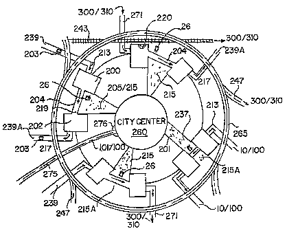
As may be noted in FIG. 1 and FIG. 12, the principal elements of the
CIS therefore include a city or town center 260 including the ergonomic hybrid
transit access corridor particularly for town and urban centers as taught in
my
U.S. Patent No. 6,561,727 BI (2003), circumferentially disposed parking
structures 200 and 202 of the type set forth in my PCT Application No.
PCT/US03/039804 entitled Mixed-Use Pedestrian-Oriented Parking Structure,
low speed mixed-mode pedestrian corridors 215 (more fully described below),
CA 02597412 2007-08-30
WO 2006/086763 PCT/US2006/004984
18
which include an outermost region 215A, that connects parking structures
200/202 to city or town center 260, feeder highways 247 that may include a
limited access or other highway beltway 265, parking structure entry and exit
highways 239 and 239A respectively, limited access highways 271 linked to
an airport 300 or seaport 310, a high speed or other rail I ink 243 linked to
airport 300 and/or seaport 310, and traffic-calmed delivery or s ervice roads
275 which approach the mixed-use pedestrian-oriented parking structures
200/202 and city or town 260, preferably as an ergonomic hybrid transit
access corridor 10/100 particularly for town and urban centers, including that
in my U.S. Patent No. 6,561,727 BI (2003). As may be noted, service road
275 ends at roundabout 276. Also shown in FIG. I are parking structure entry
ramp or entrance 213, elevated cross-over corridor 204 and parking exit 217.
Further shown are bicyclists 201, autos 203, pedestrians 205, and low speed
community transit vehicles 26 on mixed mode corridors 215.
Further shown in F(Gs. I and 12 is transfer point 220 for rail link 243,
said parking entry ramp 213 as associated with highway 239, said parking exit
217 as associated with highway 239A, and interstate highway CIS transfer
point 263 for interstate highway 267.
CIS improvements are constructed using three-story to eight-story
mixed-use buildings 40, 40a and 40b (see Figs. 6-9) that create spaces
functionally related to the human needs of the resident and visiting human
population during daily pedestrian or pedestrian-based multimodal trips from
private dwelling places to formalized business, educational, entertainment,
health and governmental settings, i.e., places to shop, to informally
socialize
and discuss community issues, to prepare for work or school.
CA 02597412 2007-08-30
WO 2006/086763 PCT/US2006/004984
19
Public spaces between buildings 40 are framed by the exterior of and
entrances or other opening to a series of mixed-use buildings that line the
perimeter of parking structures. Such liner buildings 210/212 are positioned
along wide sidewalks, pedestrian corridors 262, courtyards 264 and plazas
266, walkable and traffic-calmed streets 209 (see: Walkable Communities at:
http://www.walkable.org/index.htm and the history and type of measures that
describe Traffic Calming at http://www.trafficcalming.org/), and mixed-mode
corridors (see: John Zacharias, "The Amsterdam experiment in mixing
pedestrians, trams and bicycles" ITE Journal, vol. 69,no. 8, pages 22-28,
August 1999 available at http://www.ite.org/itejournal/index.asp.) designed to
accommodate a mix of pedestrian, bicycle and transit movements.
Specific structural components of liner buildings 210/212 (see Figs. 2-4)
and corridors 262 provide continuous open-air shelters, i.e., balconies,
arcades 241, awnings, roof overhangs, tree and other canopies, covered entry
features, courtyards and zaquanes, that protect pedestrians from the sun,
rain,
wind, heal and cold. This urban environment projects a high quality condition
that encourages active human lifestyles and related large-scale pedestrian
movements. See Pattern, Language at http://www.patternlanguage.com and
Nature of Order at: http://www.math.utsa.edu/-salingar/NatureofOrder.html).
Most parking is accommodated in specially designed parking structures
having entrances 213 that are circumscribed by said liner buildings 210/212.
Within the parking structures 200/202 (see Figs. 2-3), angled parking spaces
226 are positioned around a central elongated air/light atrium 228 and
parallel
parking spaces 227 are positioned along the outer edge of the parking
structure immediately adjacent the liner building doorways and hallways. The
parking spaces are positioned to facilitate one-directional aisles (12 to 18
feet
wide) and to be proximate to liner building businesses and residences within
CA 02597412 2007-08-30
WO 2006/086763 PCT/US2006/004984
5 the mixed-use liner building component and the destinations along the
adjacent mixed-mode corridors and traffic-calmed streets. Intermittent on-
street parallel parking spaces provide limited spaces for short term parking
opportunities (eight or so spaces per city block).
10 No or very limited surface parking lots (consisting of six or less parking
spaces). More particularly, as may be noted with reference to FIGS. 2-4,
parking deck 216 within first liner building 210 provides for parallel parking
227
at the perimeter thereof, this interrupted as necessary by pedestrian
corridors
262 (see Fig. 4), pedestrian bridges 208, and entrance platforms 211 to
15 provide a place for pedestrian access by residents, guests, business
employees, and their clients and by roadways, and preferably configured as
an e rgonomic hybrid transit access corridor particularly for town and urban
centers as is taught in my U.S. Patent No. 6,561,727 B1 (2003), vehicular
cross-over 204, and one-directional traffic aisles 207 for delivery services
to
20 access back doors 240 located at a perimeter wall 224 which comprises an
interface between parking portion 216 and first liner building 210. Further,
angled parking 226 surrounds said atrium 228 at the center of portion 216 of
first parking structure 200.
As may be noted in the embodiment of FIG. 2, direction of travel within
the garage is one way (see arrows 207) and allows for sufficient width (12 to
18 feet wide) and height (in a range of 14 to 18 feet high) for automobiles
and
delivery trucks. I ncorporated i nto t he s tructure m ay b e a c entral s
ervice or
loading docks 230 provided at a ground floor (see FIGs. 2-4). There is shown,
outwardly of the first liner building 210, a second liner building 212 (see
Fig.
3), arcades 241 and awnings, balconies, and roof overhangs which
peripherally surround said liner buildings 210/212.
CA 02597412 2007-08-30
WO 2006/086763 PCT/US2006/004984
21
Further shown in FIG. 2 are a buffer corridor 232 into which HVAC and
other environmental f acilities 2 33 may b e placed. With further r eference t
o
FIG. 3, the mixed-mode corridor 215 is preferably a ground level pedestrian-
oriented corridor situated between the mixed-use pedestrian-oriented parking
structure parts 200 and 202 that can accommodate pedestrians 205, bicyclists
201 and community transit vehicles 26.
Shown at FIG. 3 is the relationship between garage entry 213 of the
embodiment of FIG. 2 and garage exit 217, this inclusive of said vehicular
cross-over 204 which connects the respective portions of the garage. The
system thereof is shown in vertical axial cross-sectional view in FIG. 4 in
which
pedestrian bridge 208 and pedestrian corridor 262 may also be seen.
With reference to Figs. 3-4, the resultant parking structure promotes
pedestrian activity by providing a rear or back door access 240 to an
adjoining
liner building 210 and further provides interior pedestrian access corridors
214,
arcades 241 (see Fig. 4) and similar structures that protect pedestrians from
the adverse weather conditions, covered street crossing (beneath structures
that span the street between city blocks such as mixed-use cross-over 208) or
mixed mode corridors 215, traffic calmed streets (see Figs. 5-9), as is taught
in
my U.S. Patent No. 6,561,727 (2003), and mixed-use crossovers 208 and
pedestrian corridors 262 to provide pedestrian access between and through
the components of the mixed-use, pedestrian-oriented parking structure.
Said parking structure is designed to absorb traffic by efficiently
converting automotive trips into pedestrian movements that eliminate traffic
congestion and improve intermodel pedestrian access to transit and other
transportation modes and to frame public squares and pedestrian or mixed-
mode corridors and streets with horizontal components, as discussed in the
CA 02597412 2007-08-30
WO 2006/086763 PCT/US2006/004984
22
Ergonomic Hybrid Transit Access Corridor Particularly for Town and Urban
Centers of said U.S. Patent No. 6,561,727 BI (2003) 245. Within these public
spaces (plazas, courtyards, and corridors), small transit, parking shuttle and
local circulating vehicles help to more efficiently link parking facilities to
destinations within a one to four square mile area and with the mixed-use,
pedestrian-oriented parking structure, collectively, constitute a pedestrian-
oriented design and transit access system that will improve intermodel
movements within the urban community.
The above defines a better method to park automobiles within the
shroud of a 20 foot to 90 foot deep liner building (typically 60 feet or so
deep)
and to incorporate elements of interior design to produce a mixed-use,
pedestrian-oriented parking structure that positions parking spaces to better
provide access, air, light and security to customers, visitors and residents
of
mixed-use liner buildings.
Further shown in Figs. 2-3 is a one-directional driving corridor or
parking access isle 207 (see arrows of FIG. 3) to thereby provide an
opportunity to build a matched pair or more of parking structures with a third
floor vehicular cross-over 204 (see Fig. 4) to structurally integrate with a
second floor mixed-use crossover 208 for retail, restaurant or mixed-use
activities and to provide cover for mid-block, at grade pedestrian crossings
and
mixed-mode corridors 215 (see Fig. 4). The narrow width (approximately 90-
115 feet) allows for structural columns 218 to be moved to the perimeter of
the
parking structure or within said air/light well or atrium 228 to thereby avoid
shadowing within the parking structure and improve user safety. The narrow
characteristic of such structure also makes for an easier application of use
of
CA 02597412 2007-08-30
WO 2006/086763 PCT/US2006/004984
23
the liner building, given the space needs of retail, office and other
commercial
or residential uses and the typical dimensions of a city block.
Liner building sections (see FIG. 11 as one example) can be developed
through contracts with a single developer (using varied architectural firms to
design the sequence of distinctive and varied 10 to 30 to 50 feet long
building
fagade sections that face the pedestrian-oriented corridors) or through
incremental development of small, separate out-parcels (different owners,
architects and builders developing the distinct and varied liner building
sections as multiple individual buildings within and approximating the 60 feet
deep by 10 to 30 to 50 feet wide lot dimensions with no or minimal side yards)
that surround the parking structure and functionally connect the parking
spaces with the p edestrian-oriented corridors, plazas and community transit
services.
The specific building heights need to provide sufficient light and air to
the public realm to respond to all urban health and the multiple environmental
needs of the lushly vegetated public places e.g., human and compatible
animal and plant life. All components of these three dimensional spaces
should appeal to the five human senses (what we see, hear, smell, taste, and
feel) and should constitute the urban form of a "green corridor" that provides
a
sustainable environment for a variety of urban adapted wildlife and urban
compatible domestic animals. Because a continuous array of buildings at or
above 85 feet in height can create environmental problems within the corridor,
courtyard, plaza, pedestrian via, zaquan and other microclimates, buildings
sized down to three-story heights or occasional buildings above eight-story
heights for specific large scale uses should be placed within the urban form
where they add to and do not detract from these CIS objectives (see:
CA 02597412 2007-08-30
WO 2006/086763 PCT/US2006/004984
24
Microclimate and Downtown Open Space Activity available through;
http://eab.sagepub.com/cgi/content/abstract/33/2/296).
Within this pedestrian-oriented environment, large numbers of people
walk longer than typical distances because they enjoy the experience.
Architectural features vary every 10 to 30 to 50 feet based upon different
uses
and i ndependently conceived a rchitectural d esigns that a re o bservable
from
the public realm at close (30 feet or less), intermediate (30 feet to 300 feet
or
so) and greater distances (300 feet or more). These features must provide not
only visual interest, but also provide other sensory reinforcement
opportunities
(what one hears, smells, feels, and tastes).
In the traffic calmed streets (see FIGs. 13-14) of the type of the
Ergonomic Hybrid Transit Access Corridor Particularly for Town and Urban
Centers as is taught in U.S. Patent No. 6,561,727 B1, there are delivery and
service roads 275, and elevated ramps from the limited access highways 271,
positioned to link the cars and trucks from the limited access and feeder
other
highways 267 and 247 respectively with the mixed-use pedestrian-oriented
parking structure 200/202, the pedestrian corridors 262, mixed-mode corridors
215, courtyards 264, and plazas 266 to connect the car and truck occupants
(when they become pedestrians, bicyclists, and community transit users) with
the city or town center 260.
With reference to t he v iews of FIGS. 5 t o 9, t he instant e rgonomic
hybrid transit access corridor 10 or 100 may be seen to include a plurality of
x-
axis integral, y-axis corridor segments. Therein, as may be noted, each
corridor segment is characterized by a longitudinal or y-axis of indefinite
length, however limited by x-axis intersections 12 more fully addressed below.
It may, with reference to FIGS. 5 through 8, be appreciated that the instant
CA 02597412 2007-08-30
WO 2006/086763 PCT/US2006/004984
5 ergonomic hybrid transit access corridor is characterized by a preferably
centrally disposed bidirectional roadway consisting of lanes 14 and 15, each
having a width preferably of 9 to 12 feet, which may be preferably separated
by a roadway median 16 having a width of about 5 to about 20 feet. See
embodiment of FIG. 7. Provided outwardly of lanes 14 and 15 are parallel
10 parking segments 18, each having a width preferably of 8 to 9 feet.
In the elaborated embodiment of FIGs. 7 and 10, bicycle lane
segments 19, each having a width preferably of 4 to 5 feet, are provided
between roadway lanes 14a/15a and said parallel parking segments 18, 18a
15 and 18b In the rudimentary embodiment of FIGS. 5-6, bicycle lane segments
may be integrated or separately arranged from first greenscape segments 20
described below. In the alternative, the bicycle lane segments 19 can be
widened to 7 feet to accommod'ate intermittent use of the bicycle lane by
narrow gauge rail vehicles 26 as well as bicyclists 201 and that in such
20 instances, the narrow gauge rail tracks 24 may have an x-axis with in the
range of 30 to 40 inches and thereupon a moderate speed, e.g., 20 to 30
miles per hour, low profile, an electric, diesel hydraulic, steam, or other
propulsion system, tram, trolley, train, or like transit vehicles 26 having a
floor
28 (in the horizontal xy plane) situated as a level not exceeding about 20
25 inches above the plane of the bicycle lane 19.
Situated yet further symmetrically outwardly from parking segments
18 are said greenscape segments 20, having a width preferably of 3 to 6 feet
or more when other segments or other corridor features are incorporated
therein, which may include any of a variety of landscape and hardscape
treatments and which can be used to laterally move from one corridor segment
to another. Outwardly thereof are greenway transit segments 22, having a
width p referably of 15 to 4 0 feet, which g enerally i nclude n arrow g auge
rail
CA 02597412 2007-08-30
WO 2006/086763 PCT/US2006/004984
26
tracks 24, that is, tracks having an x-axis width in a range of 24 to 30
inches
and thereupon, a low speed, e.g., 5 to 10 miles per hour, low profile
preferably
electric, battery powered, tram, trolley, train or like transit vehicle 26
having a
floor 28 (in the horizontal xy plane) situated at a level not exceeding about
20
inches above the plane of the greenway transit segments 22.
It is to be appreciated that each of the greenway transit segments 22
are multi-use in character, that is, functional for purposes of pedestrian and
low speed bicycle or similar conveyance use both during periods when the
small transit vehicles 26 are not present and, at lateral sides of the small-
gauge rail tracks 24, when such transit vehicles 26 are upon the rail
component of the greenway transit segment 22.
Optionally disposed beneath each greenway transit segment 22 (see
FIGS. 6 and 7) is a multi-purpose underground utility conduit 30 as is taught
in
my U.S. Patent No. 6,167,916 B1 (2001) 30 which serves as a means of
unified utility delivery. As such, this multi-purpose underground utility
conduit
includes subconduits for electricity; drinking water, re-use water, sewer
lines and storm water drainage; natural or synthetic gas; telephone, cable
television, fiber optics, and other communication and data transmission
25 means; pneumatic tubes; security services; fire services; and low current
magnetic induction tracks for vehicular propulsion. In addition, utility
conduit 30
may be employed for storage, maintenance access, or transit power
equipment for the greenway transit segments 22.
With further reference to FIGS. 5 and 6, there are located, further
30 symmetrically outwardly from the greenway transit segment 22, second
greenspace segments 32 which, as in the case with first greenspace
segments 20, may include a variety of landscape and hardscape treatments
and which can be used to laterally move from one corridor segment to
CA 02597412 2007-08-30
WO 2006/086763 PCT/US2006/004984
27
another. Each of the greenspace segments 20 and 34 provide filtered sunlight
and shade tree coverage for an optimum foliage spread of such segments and
adjoined areas, as well as opportunities to install fountains and other
artistic or
architectural features to provide comfort and interest to the individuals
traveling within the corridor segments.
Symmetrically o utwardly beyond lateral s egments 32 are p edestrian
arcade-like segments 36, 36a and 36b having a width preferably in a range of
10 to 15 feet. The preferred xz plane cross-section of arcades 38 within
segments 36 is shown in FIGS. 6 and 7. Therein it may be appreciated that, in
a preferred embodiment, arcade 38 of segment 36, 36a or 36b is, in the xz
plane, enclosed on two or three sides by architectural structures 40a and 40b
which, at surface 42, provide for commercial stores and fronts thereof which
may include therein a variety of y-axis uses and attractions.
The number and length of the store fronts or architectural details of
surface 42 are designed to protect the pedestrian from the rain, wind, heat
and
cold, and to optimize pedestrian spacing and interest to urge the pedestrian
to
move continually forward along the y-axis toward a destination or transit
linkage 12. A maximum distance for such pedestrian movements are defined
in accordance with established psychological and medical criteria of how far a
pedestrian can comfortably walk, in the given climate where the greenway
transit system is located, before beginning to loose interest, perspire or
tire,
given the typical mental and physiological characteristics of individuals
moving
through the corridor segment.
Related to the time that it would typically take a consumer to walk
along a pedestrian arcade segment 36 between destinations or transit use
opportunities 12 is the periodicity of the schedule of community transit
vehicles
CA 02597412 2007-08-30
WO 2006/086763 PCT/US2006/004984
28
26, the various rail services such as said link 243, bus transit systems, and
other modal choices and a variety of end uses or refinements of the
architectural design details. Accordingly, the schedule of the transit
vehicles
26 as well as the land use itself and architectural design variations are a
function of typical physiologic and psychological considerations.
With reference to the top or xy plane view of FIG. 8, the lateral
relationship between the e ntire above defined integral corridor segments 10
may be seen. Therein, as may be appreciated, are shown said greenway and
enclosure ratios, which comprise two of the defining parameters of the present
system. More particularly, the greenway ratio is defined as the ratio of the x-
axis dimension of roadway 14/15, any roadway median, and parallel parking
segments to the entire x-axis dimension of the corridors 10 or 100 (see FIG.
7). This ratio, in the instant system, exhibits dimensions that will not
exceed
fifty percent. The enclosure ratio is defined as the ratio of the z-axis of
height
of t he architectural structures to the entire x-axis d imension of the
corridor.
This ratio in the instant system, at optimal dimensions, is at least thirty to
about fifty percent. For example, if the width of each vehicular lane is 10
feet
and the two lane roadway is therefore a width of 20 feet, the total x-axis
dimension of the corridor will be at least 40 feet. With two 8-foot wide
segments for parallel parking, the width of the corridor 10 or 100 would be 72
feet or greater. In such an example, the z-axis height of the architectural
structures would range from at least 24 feet to about 36 feet.
A four lane roadway 14 and 15 (see FIG. 7) includes parallel parking
segments 18 to produce a width of the corridor 10 or 100 of 112 feet or more
with a 15 foot roadway median between each two lane roadway sections, the
width of the corridor 10 or 100 would be 142 feet or more. The z-axis height
of
architectural structures 40 and 40a would range from about 37 feet to 56 feet
CA 02597412 2007-08-30
WO 2006/086763 PCT/US2006/004984
29
in the first instance and about 47 feet to 71 feet in the second instance.
Even
at a maximum highway lane width of 12 feet, the overall width of the corridor
would typically be at least two times the width of the roadway, the roadway
median and the parallel parking segment.
, Per FIGs. 9A/9B, it is noted that arcade 38 may be defined through the
use of arcades 38, balconies, porches, awnings, roof overhangs, zaquans,
pedestrian vias, and other pedestrian and bicycle related shelters. That is,
it is
noted that vertical surface 42 defines an xz plane interface between the
public
right of way a nd p rivate architectural structures s uch as structures 4 Oa
and
40b. These structures may be retrofitted to provide for arcades 38 or,
alternatively, lobbies, courtyards, zaquans, or pedestrian vias.
In Fig. 9A, it is to be appreciated that within greenway transit segment
22 and greenspace segments 20/32 may be seen bicycle lanes 19 or walking
trails. Also, all aspects of the corridor are provided with strategic
architectural
lighting for purposes of safety and aesthetics.
It is noted that said corridors 10 and 100 may comprise segments of
larger linear, bi-directional, uni-directional, or loop-like planning
configurations
within said city or town center 260.
In the pedestrian corridors 262 (see Figs. 4 and 13-14), the mixed-
mode corridor 215, the ergonomic hybrid transit access corridor 10/100 (see
Figs. 6-7) for town and urban centers as taught by my U.S. Patent No.
6,561,727 BI (2003), and traffic calmed streets 209 (see Fig. 13-14),
different
senses operate at different distances, causing each sense to act in sequence
to propel or redirect pedestrian movements in very predictable ways. What you
see at a distance, you can hear and smell at closer quarters. What you see,
CA 02597412 2007-08-30
WO 2006/086763 PCT/US2006/004984
5 hear and smell at close quarters, you can touch. What you see, hear, smell,
and touch, you can taste, but only with the direct oral contact with the
object or
entity to be tasted.
This d ifferential i n t he s ensory r eception distance f orms the b asis f
or
10 the pedestrian propulsion system and the steering capacity of CIS urban
forms
(pedestrian-oriented corridors, plazas, traffic-calmed streets) in conjunction
with large-scale pedestrian movements. With the use of a full range of human
scales and the fractal qualities in the urban built and naturally-occurring
structures and designs to excite visual interest at long, medium and short
15 distances and the variety of needs that can be satisfied within mixed-use
environments, pedestrian interest can be converted into a predictable and
fully
operational method of intermodal transport. (Saiingaros, The Future of Cities
[2006] at: hfitp:I/www.math.utsa.edu/sphere/salingar/futurecities.html, A
Theory
of Architecture [2006] at: http://www.math.utsa.edu/-
salinaar/architecture.html,
20 Principles of Urban Structure [2005] at: http://www.math.utsa.edu/
sphere/salingar/urbanstructure.hfiml, and Pavements as Embodiments of
Meaning for a Fractal Mind [2000] at: http://www.nexusiournal.com/Miki-Sali-
Yu.html.
25 In addition, the pedestrian corridors 208 and 262, the mixed-mode
corridors 215, the ergonomic hybrid transit access corridors 10/100
particularly for town and urban centers as is taught in my U.S. Patent No.
6,561,727 B1 (2003), outer plazas 215A, courtyards 264, traffic-calmed streets
209, and the adjacent built and landscape environment, provide comfortable
30 places to sit during both the walk and ride phases of typical multimodal
trips,
i.e., provides comfortable and well-lighted places to sit, eat, socialize,
protected from the natural elements. Doorways, windows, balconies and other
entry features (see FIG. 11) provide frequent openings to the liner buildings
CA 02597412 2007-08-30
WO 2006/086763 PCT/US2006/004984
31
210/212 from plazas 266, courtyards, mixed-mode corridors 215, sidewalks
and traffic-calmed streets 209. Zaquanes, pedestrian vias, and galleria or
shopping mall corridors transect city blocks to create short pedestrian blocks
(see: Jane Jacobs, The Death and Life of Great American Cities, 1961) and
pedestrian access to shops, restaurants, hotel lobbies, and residences within
the city block structures (see: Bernard Rudowsky, Streets are for People: A
primer for Americans, 1969). Places to sit and short blocks help to form a
healthy walking environment, without exhaustion.
Finally, the provision for ultra-low floor community transit vehicles 26
(see F IG. 10) allow for easy access from a ny sidewalk i nto a v ery human-
scale vehicles (seven feet wide by nine feet tall) that functionally represent
a
slow moving, pedestrian-benign bench on wheels that move generally toward
the many desired areas of the urban center. In such circumstances, the
opportunity to sit, rest, ride and walk provides for larger pedestrian
supportive
areas and longer pedestrian-oriented multimodal trips.
Cars 203 remain a dominant method of transport, but they are parked
in mixed-use pedestrian-oriented parking structures 200/202 surrounded by
liner buildings 210 (see FIGS. 1-4) that help form this consistently
reinforced
pedestrian-oriented urban form and habitat in the public space between
buildings. The pedestrian movements are much more visible and automobile
and truck traffic i s m uch less visible when compared to more typical urban
environments elsewhere in the world. Air quality is improved and pedestrian
safety is assured due to the very limited vehicular movements within these
urban centers.
All multimodal trip needs are addressed so that a significant pedestrian-
based m odel shifts to alternative modes o f t ransport (bike racks, clean a
nd
CA 02597412 2007-08-30
WO 2006/086763 PCT/US2006/004984
32
safe public wash rooms, lockers, phone and internet services, food and drink
outlets, way finding, mobility centers, abundant structured parking spaces,
seamless transportation services and modal transfers for individuais and
groups. As a result of the large-scale pedestrian movements, nearby mixed-
use pedestrian-oriented structured parking and high quality public places for
enhanced intermodal access, far larger numbers of the traveling public u se
public transport, automotive traffic congestion is reduced, and virtually all
automotive trips can become multimodal trips.
Such community intermodal systems assume an intermodal community
built environment that provides for all human needs, e.g., governmental,
religious, commercial, health, education, entertainment, cultural,
residential,
and employment. Further, it assumes that the transportation systems that
operate between and within the community intermodal system car-free centers
(see: Carfree.com at: http://www.carfree.com/ ) or other pedestrian-oriented
urban centers are safe, reliable, energy efficient, technologically advanced,
and environmentally benign and that they enhance the region's global
economic competitiveness, productivity, and quality of life. Finally, while
specific single purpose buildings, especially those with more than eight
floors,
will exist within the pedestrian-oriented urban center, their first three
fioors or
more will help to frame the high quaiity human habitat and provide for
specific
community needs within the CIS urban form, i.e., restaurants, retail goods and
services, health related, social and governmental services.
Further, within a city or town center 260, the CIS components are
themselves defined to specify that:
= The corridor, courtyard and plaza components (see FIGS. 5-9,
12-15). T hese assume wide pedestrian corridors 262 (30 feet
CA 02597412 2007-08-30
WO 2006/086763 PCT/US2006/004984
33
wide or more), wider mixed-mode corridors 215 (50 feet wide or
more), courtyards 264 (60 feet square or so) and larger plazas
266 of varying shapes and sizes (100 feet square or more) act
as gathering places for business, social and recreational
functions, i.e., market in the morning, lunch in the afternoon,
festivals at night; a partiai tree canopy p rovide shade from the
sun, open areas provide sunny places to sit or walk and water
features provide for human needs, interest and comfort (drinking
fountains, decorative fountains, water courses and water falls
provide cool places to sit, visually interesting places to be and
physically revitalizing environments) public art provides visual
interest and, when properly constructed and designed, places for
children to play; brick, stone or similar corridor and plaza
surfaces provide surfaces sufficiently rough enough so as to be
inconsistent with fast moving a nd dangerous automotive traffic
and consistent with p edestrian walking n eeds; grass a reas are
large enough to sit, run and play and provide for water recharge
and psychological linkages to our genetic past; continuous
building faces protect the pedestrian from the sun, rain, wind,
heat, and cold; elevated and covered entry structures associated
with pedestrian-oriented mid-block crossings provide platforms
for building and transit entries protected from any adjacent
automotive traffic and the weather; attractive and useful
landscape and hardscape provide color, shapes and smells
responsive to human needs and wants; mixed-use buildings
(See FIG. 11) open to the street at frequent intervals (doors,
balconies, and windows at 30 foot or more frequent intervals);
wider sidewalks or arcade-like segments 36 (15 feet wide or
more), courtyards 264, plazas 266, adjacent traffic calmed
CA 02597412 2007-08-30
WO 2006/086763 PCT/US2006/004984
34
streets 209, Ergonomic Hybrid Transit Access Corridor
Particularly for Town and Urban Centers as is taught in my U.S.
Patent No. 6,561,727 B1 (2003) 245, mixed-mode corridors 215,
and pedestrian vias, zaquanes, and gaileria and shopping maii
corridors (30 feet wide or more) provide a consistent, predictable
and safe pedestrian course through and to the city center;
narrowed automotive traffic lanes (10 feet wide or less) reduce
average traffic speeds, wider shared-use bicycle and community
transit traffic lanes traffic lanes (seven feet wide or so) improve
car-bicycle accident safety, and limited on-street parking
(configured as intermittent parallel parking on traffic-calmed
streets alternating with movable or stationary sidewalk bulb-outs
at each end of city blocks and at mid-block in coordination with
identifiable pedestrian-oriented street crossings) provide with
other traffic-calming techniques a safer mix of automotive,
community transit, pedestrian and bicycle movements outward of
the urban center; environmental street shutters that span the
distance between buildings from opposite sides of pedestrian-
oriented corridors above the third floor level are constructed of
sail cloth, shade cloth or similar materials and move or rotate
during the hours of the day and night to improve walking
conditions by deflecting wind and rain from or to the public
spaces below; calmed or no vehicular traffic for all or most of the
day, week, and year to induce more pedestrian movements and
reduce accidents between pedestrians and automotive traffics
and resulting injuries; and, liner building faces that do not form a
uniform plane reflecting the dimensional differences consistent
with independently designed building face segments every 10 to
30 to 50 feet or so.
CA 02597412 2007-08-30
WO 2006/086763 PCT/US2006/004984
5 = The structured parking components 200/202 assume that
parking structures (see FIGS. 1-4 and 12-16) are located at the
perimeter of the pedestrian-oriented d owntown or urban center
260; one-directional vehicular movement 207 within the parking
structure from access to exit points; parallel parking 207 a iong
10 the parking structure outer edge; angle parking 226 around a
central air/light atrium 228 that provides for landscape and
drainage areas; longer and more narrow parking designs than
are typical in urban setting today; mixed-use liner buildings
210/212 that surround the parking structure (10 to 30 to 50 feet
15 in width and 60 feet or so in depth); self-powered, handicapped
accessible elevator systems; and, elevated and below grade
traffic aisles 268 between parking structures.
= The community transit component (see FIGS. 9-10) assumes:
small, fixed guideway community transit 26 (seven feet wide by
20 nine feet tall) with an ultra-low vehicular floor (five inches from
the road surface or flush with the sidewalks) to improve access
at all places where the transit vehicle might stop; fixed rail and
"on demand" rubber tire community transit service between
downtown and urban center destinations beyond the length of a
25 comfortable walk (beyond a one-quarter mile distance) and
between modal access points, major community destinations, or
other CIS sites; sound notification vehicle arrival systems built
into the fabric of the community's music and sound systems so
that music played on the community transit vehicles interacts
30 with the music played at stationary locations where the
community transit vehicle typically stops creating a stereophonic
effect at such transit stops; and vehicles that quietly operate at
low speed (five to ten miles per hour) on mixed-modes corridors
CA 02597412 2007-08-30
WO 2006/086763 PCT/US2006/004984
36
within downtowns and urban centers and at higher speeds (ten
to t wenty-five m iles per hour) within wide (seven feet) shared-
use bicycle and community transit traffic lanes on traffic-calmed
streets outwardly for up to a five mile radius of the CIS.
= The car-free city or town center 260 (see FIGs. 1, 4 and 13-16)
assumes: the absence of a vehicular street grid at the downtown
or urban center 260; access to direct freight deliveries at specific
times of the day; convenient shared loading docks 230 for
nearby freight movement at any time of day; nearby parking
structures that keep car movements separate from the
pedestrians in the care-free center (by use of liner buildings and
elevated and below grade traffic aisles 268 between parking
structures); pavement surfaces of decorative stone, brick, or
similar surfaces that provide a pedestrian supportive pattern,
natural drainage, a brick, cobblestone or other mixed-mode
traffic-calmed streets 209 (see Fig. 16) that provides a rough ride
to rubber tire vehicles and ADA acceptable walking conditions;
extra efforts to make the building faces lively, unique,
memorable, and characterized by features that provide a
continuous protection to pedestrians from the natural elements,
e.g., the sun, rain, wind, heat, and cold, and to make the plazas
and courtyards areas comfortable as places to sit, rest, and
socialize, i.e., market in the morning, lunches in the afternoon,
festivals at night; smaller corridors that open to much larger
plaza areas; significant community buildings 40 positioned on the
perimeter of plazas 266 (places of worship, government, market
areas, health care, education, and entertainment facilities,
museums, major residential buildings or hotels and places of
employment); underground utilities that can be installed where
CA 02597412 2007-08-30
WO 2006/086763 PCT/US2006/004984
37
necessary in conduit beneath the sidewalks, pedestrian-oriented
mixed-mode corridors 215, shared-use bicycle and community
transit traffic lanes, and traffic-calmed streets 209: and, property
values will substantially increase in the car-free areas (at least
ten times the pre-CIS values) because people converse more
frequently and with greater civility, freight moves efficiently to
and from CIS destinations and beyond, the cultural, civic, and
family life of the citizens improves and the local economy grows.
= The limited access roadways 239 (see FIG. I and 14) assume
that: from existing or to be developed Interstate Highway
System, toll roads and other major roadway intersections,
access ramps are designed and built to give direct or nearly
direct access to the parking structures; and, such direct access
reduces congestion on the highway system by providing an
alternative to sitting in your car on the congested Interstate
Highway, toll road or major roadway segment, i.e., park and find
things to do, places to eat, people to see or entertainment within
the CIS; park and access other modes of transportation as a
pedestrian 205 that are timely alternatives for local, regional or
interregional destinations; park and visit friends, businesses at
nearby CIS sites.
= The elevated parking structure cross-over 204 (see Figs. 1 and
4) and below grade parking structure traffic aisles 268 (see Fig.
15) and at-grade traffic-calmed access streets assumes:
vehicular movement will generally occur from one parking
structure 200 to the next 202 along elevated or below grade
traffic aisles to minimize car/pedestrian conflicts in the car-free
center; and, when the elevated traffic aisles are routinely
positioned at the third level, mixed-use space can be constructed
CA 02597412 2007-08-30
WO 2006/086763 PCT/US2006/004984
38
underneath it (spanning the distance between parking structures
at the second level) to provide useful and interesting vistas,
additional structural components of the CIS and shelter from the
weather when pedestrians cross the street (at the ground floor
level) beneath this mixed-use and vehicular aisle street-spanning
structure.
The CIS design as described differs from currently conceived transit
oriented development (TOD) practices (see the materials, descriptions, and
references found at: http://www.vfipi.org/tdm/tdm45.htm) due to following CIS
attributes:
= an abundance of structured parking immediately accessible from
the interstate highway system 267), toll road or other major
roadways;
= liner buildings 210/212 that surround long and narrow parking
structures that are positioned and constructed to shape the
mixed-mode corridors, courtyards and plazas a nd to m aximize
pedestrian movements;
= a car-free center that would diminish or eliminate the traditional
street grid at the center where pedestrian-oriented corridors 262,
courtyards 264 and plazas 266 connect destinations (see Figs.
12-14);
= traffic-caimed streets that access the parking structures and
connect the CiS to other CIS, TOD, or significant community
destinations (one to five miles outward from the urban center) on
roadways constructed to provide for multimodal movements,
specifically including a continuous seven foot wide or so shared-
use lane for bicycle and narrow gauge rail or other community
CA 02597412 2007-08-30
WO 2006/086763 PCT/US2006/004984
39
transit vehicles and TOD sites at one mile or so frequencies
along the multimodal corridors; and
= community transit that moves to, from, and through the CIS and
the intermodal community's city or town center 260 to riearby
destinations.
Such CIS improvements (see F1Gs. I and 12-13) provide for sufficient
parking and density and intensity of use within a one-mile or so radius from
the
intermodal access points to assure the efficient and effective conversion of
substantial automotive trips (30 percent or more) into multimodal trips where
pedestrian, bicycle, transit, rail, waterborne and air transport movements
complete the automotive trip segments. As many modern airport terminals
provide easy access from automotive, transit or rail modes to the aircraft
point
of entry gates, such community-based, pedestrian-oriented intermodal
systems will provide seamless intermodal transfers for multiple modes and
increase rail, transit and intercity bus use, such as rail-to-parking-
structure
transfer 220, transfer 263 between interstate 267 and feeder highway 247.
At its core, the inventive intermodal and transit improvements aims to
convert automotive travelers to pedestrian, bicycle, and transit users while
encouraging private sector investments in community economic development,
i.e., liner buildings related to the parking structures and other building
projects
within t he C IS that p rovide places t o I ive, w ork, pray, m arket and s
ocialize.
Mixed-use liner buildings would be built upon land acquired in bulk to
construct
parking structures, sidewalks, the pedestrian-oriented mixed-mode corridors
and p lazas, a nd the traffic calmed streets. 0 nce s uch land has been m ade
available for the intermodal improvements, e.g., parking structures, mixed-
mode corridors, plazas, sidewalks and streets, the surplus lands can be sold
to the appropriate bidder for liner buildings or other community building uses
CA 02597412 2007-08-30
WO 2006/086763 PCT/US2006/004984
5 absent a private/public partnership to reserve such land for the property
owners who pursue with the affected local governments a cooperative
development strategy.
This transfer from automotive to alternative modes is in part
10 accomplished by: connecting the long and narrow parking structures directly
to
the interstate off-ramp to improve car access to parking spaces; and, by
keeping the walking distance as short as possible between the parked car and
liner building destinations (from 5 to 40 feet) or between the car and the
mixed-mode corridor 10/100 (from 70 to 100 feet) providing high quality
15 pedestrian and transit access to multiple community destinations. (See
FIGs.
12-14)
Other conditions that f avor parking to pedestrian to transit intermodal
transference are incorporated into: attractive and interesting architectural
20 designs; safe, comfortable, useful, and interesting activities that can be
undertaken along the mixed mode corridors, courtyards and plazas; and
beneficial social interaction that occurs in the pedestrian-oriented and
socially
conducive public spaces between the car and the desired destinations.
25 There are multiple transportation related funding strategies that can be
pursued to develop CIS improvements and multimodal transportation systems.
Regardless of the statutory funding provisions that are used, it is clear that
CIS
related funding requests, when properly pursued, will be productive when the
improvements are shown to serve a valid transportation purpose. While such
30 improvements will simultaneously provide support for community and
economic development goals and strategies, they will function as a highly
successful intermodal system of transportation improvements.
CA 02597412 2007-08-30
WO 2006/086763 PCT/US2006/004984
41
Other economic impacts to be explored relate to the real estate value
increases that can be expected when implementing pedestrian-oriented
strategies. Throughout the world, downtown redevelopment successes h ave
well established that the value return from thoughtful design and
architectural
variety when compared to similarly situated downtowns that allow lesser
design standards to prevail. It would be safe to postulate that a ten fold
property value change occurs between communities which insist upon the
good pedestrian-oriented community designs compared to those that allow
pedestrian-adverse good designs to prevail, given similar densities and modal
access.
With such economic impacts derived from pedestrian-oriented designs,
property owners are better positioned to partially self finance intermodal
projects that include CIS improvements and TOD communities and will be
stronger partners with government once planning and project commitments
and development agreements h ave been secured. F urther, shouid the sites
where the CIS is developed be located within a community redevelopment
district or similar governmental tax arrangements, then tax increment
financing
(TIF) and public bond financing, and other financial development plans add an
additional level of governmental, property taxed based, funding options.
In the development of successful CIS improvements and TOD
communities, care must be taken to organize the uses that are required for
daily pedestrian needs. In the hallmark work of Lewis M umfort, The City in
History: Its Oriqins Its Transformations, and Its Prospects (1961) (see:
http:/fwww.amazon.com/qplreader/O1 56180359/ref=sib dp pt/104-8867215-
2876748#reader-page), the essential city functions and building types are
identified and placed in their historic context. Summarizing his conclusions,
the
buildings and uses that need to be established with any sustainable
CA 02597412 2007-08-30
WO 2006/086763 PCT/US2006/004984
42
community, TOD or C1S can be identified. These functions and the buildings in
which they are housed are:
= Governmental buildings providing public services to the citizens
(courthouse, police and fire station, regulatory approvals, etc.).
= Religious buildings and faith-based or other family and child care
services.
= Marketplaces (especially food, flowers and local crafts) in public
plazas and courtyards, the buildings adjacent public plazas and
courtyards, the pedestrian-oriented mixed-mode corridors and
traffic-calmed streets.
= Hospitals, healthcare providers and therapeutic spa facilities.
= Education, recreation and parks facilities.
= Theatres and entertainment venues.
= Museums and cultural facilities.
= Residences.
+ Places of work such as commercial offices, businesses and a
variety of retail establishments that support urban life, i.e.,
restaurants, laundries and dry-cleaners, shoe repair shops,
newspaper stands, drug stores, fruit and vegetable markets,
bakeries, bicycle shops, candy stores, flower shops, tobacco
shops, coffee and donut shops, copy services, pet stores,
computer sales and services businesses, weight loss centers,
exercise and athletic facilities, bait and tackle shops, cell phone
stores, dentists, eye doctors, clothing stores, furniture outlets,
glass wear and kitchen supply stores, hardware stores, barbers
and hair salons, ice cream parlors, insurance and investment
services offices, banks, accounting services offices, law firms,
butchers, music stores, book stores, second-hand stores and
CA 02597412 2007-08-30
WO 2006/086763 PCT/US2006/004984
43
pawn shops, realtors, storage facilities, toy stores, mobility
centers, wine merchants.
Each and every use benefits economically from the large scale
pedestrian activity adjacent its location along the mixed-mode corridors,
plazas, courtyards, sidewalks, and traffic-calmed streets. The crowds, whether
they are residents, customers, or visitors just passing through, represent a
social life that is good for business and the social interchange of a
cooperative
working community.
While business owners and residents share the parking spaces that are
located behind each liner building, the use thereof is preferably is staggered
with different hours or shifts of work, residential occupancy and visitor,
traveler, or customer parking needs. Density that adds value to land use and
enhanced transit ridership is accomplished by both building heights (uniformly
three to eight story buildings with occasional taller buildings as approved by
City ordinance) and the reduced use of land for automobile transport.
Because the public spaces are well designed and represent public
living areas, residential units can be reduced in size as more life can be
enjoyed out of doors. Smaller units mean reduced housing costs even in high
land value communities. Fewer cars (the return of one and two car families
and the emergence of no car families or individuals) mean more disposable
income for housing, travel and cultural events.
Housing costs are further reduced because parking costs are shifted to
federal and state transportation funds and parking spaces are shared with
commercial/customer daytime users. When all of the development investment
is spent on residential and commercial structures (not on the road access to
CA 02597412 2007-08-30
WO 2006/086763 PCT/US2006/004984
44
parking improvements, the parking improvements or the land between
buildings used for parking), housing costs are reduced and even high value
properties become more affordable.
Simultaneously, community development can proceed without the use
of local governmental general revenues because CIS funding is provided
principally from federal and state transportation sources, from TIF funds,
public bond financing, and from other governmental and private sources,
augmented by HUD, SBA and other federai and state financing tools. In
addition, because of the conversion from automobile to pedestrian, bicycle,
and mass transit modalities, community health and vitality is substantially
enhanced. Further, these community environments improve the urban lifestyle
by incorporating educational resources, public art, the creative industries,
commercial, retail, a nd e ntertainment d istricts within the clean-and-safe,
24-
hour activity zones.
While there has been shown and described the preferred embodiment of
the instant invention it is to be appreciated that the invention may be
embodied
otherwise than is herein specifically shown and described and that, within
said
embodiment, certain changes may be made in the form and arrangement of the
parts without departing from the underlying ideas or principles of this
invention
as set forth herewith.