Note : Les descriptions sont présentées dans la langue officielle dans laquelle elles ont été soumises.
CA 02608558 2013-07-16
1
Phase ambiguity resolution method for a satellite-based
positioning system
The invention relates to a phase ambiguity resolution
method for a satellite-based positioning system and a
computer program product.
For position determination, global or satellite-based
positioning systems GNSS (e.g. GPS, GLONASS, GALILEO,
etc.) are currently being used for many applications
and will be in the future. For
this purpose, the
satellites of the space segment emit electromagnetic
radiation at a plurality of carrier frequencies. In
general, one or more codes which serve for the
transmission of data are superposed on these carrier
frequencies by modulation.
The electromagnetic radiation is detected by a receiver
and evaluated with regard to different variables for
position determination. Thus,
on the basis of the
transit times of the signals from a satellite to the
receiver, so-called pseudo-paths are determined, these
deviating from the true distance owing to various
influences, such as, for example, owing to the
difference between true system time and the respective
representations in the satellite and receiver clocks.
These pseudo-path measurements are based on the code
which is superposed on a carrier frequency by
modulation and contains data about the time of emission
of the signal by the satellite. The satellite signals
are transmitted at a plurality of carrier frequencies
which are designated, for example for the GPS system,
by L1 (154-10.23 -106 Hz), L2 (120-10.23.106 Hz) or L5
(115.10.23-106 Hz). In the
case of GALILEO, for
example, the corresponding frequencies are designated
as E1-L1-E2 and E5a (L5), E6 at (125.10.23-106 Hz) being
Mk 02608558 2013-07-16
2
available as a third signal. Other
frequencies can
likewise be measured in the case of GALILEO.
A further possibility for distance determination
consists in the use of carrier phase data of the
signals. The measurement of the phase shift is carried
out, the use of the carrier phases permitting a precise
position determination.
However, the disadvantage of
the phase measurements is that their distance is
determined only to a multiple of the wavelength used,
which is designated as phase ambiguity. If these phase
ambiguities were known, so-called phase paths as highly
accurate equivalents to the pseudo-paths would have
been available - based on the carrier phases. Phase
paths are obtained by multiplication of the
observations with the aid of the carrier phases in
cycles with the wavelength applicable in each case.
By utilising two frequencies, it was originally
intended to correct ionospheric transit time delays,
but special combination phases can also be generated by
linear combinations, such as, for example, ionosphere-
or geometry-free linear combinations. Such
linear
combinations, i.e. in general a summation of any
desired multiples of n elements xl to be combined, i.e.
X = Earx, (0)
with the associated positive or negative coefficients
and optionally additive terms independent of the
elements, may be generated for pseudo paths as well as
observations of the carrier phases, i.e. the phase
paths. For
this purpose, the corresponding
observations are multiplied by certain factors. For
generating a geometry- or ionosphere-free linear
CA 02608558 2013-07-16
3
combination, real-value factors are used. The
real-
value factors destroy the integral nature of the phase
ambiguity for the exact determination in an algorithm.
If integral factors are used in the linear
combinations, the integral nature is retained for the
determination within an algorithm.
The combination of carrier phases and pseudo-paths at
both wavelengths for resolving so-called "wide lanes"
was developed in the 1980s. A first,
civil GPS
receiver with pseudo-path measurement at both
frequencies was on the market at that time. This
receiver used the still unencrypted P-code, both at the
L1 frequency and at the L2 frequency. The
measured
pseudo-paths were substantially more accurate than
pseudo-path measurements with the aid of the C/A code
(300 m wavelength), owing to the shorter code
wavelength of about 30 metres. L1 and L2 pseudo-paths
as well as Ll and L2 carrier phase measurements were
recorded. In the
case of the "wide lanes", only
integral factors are used and hence the possibility of
the advantageous determination of integral phase
ambiguities is retained.
The principle of the combination of the observations of
two frequencies consists in the elimination of the
terms common to all observations, combinations of
oblique paths to the satellite, troposphere and the
like and of the dispersive, ionospheric term which has
a different sign for pseudo-paths and phase
measurements. While in general resolution is effected
only for the advantageous wide lane, the method can be
set up for any desired linear combinations of two
frequencies. It
should be noted here that the
resolution of the wide lanes between a station and a
satellite is possible only in theory.
Between the
frequencies, different clock errors in the satellite
CA 02608558 2013-07-16
4
and the receiver hinder this possibility. For
this
reason, a resolution can be effected only after the
formation of so-called double differences between two
satellites and two receivers or the introduction of the
respective clock differences.
This approach of using two frequencies and the
measurements of the coordinated carrier phases and
pseudo-paths combines the accuracy possible in
principle with the carrier phase with the determination
of the phase ambiguity, which is possible by the
pseudo-path measurement. The so-
called Melbourne-
Wubbena approach, in which phase and pseudo-path
measurement are combined in a system of equations to be
solved permits a direct resolution. Here, the carrier
phase measurements are stated as phase paths, i.e. in
metric units instead of cycles otherwise usually used -
the so-called phase path is obtained by multiplication
with the wavelength of the respective carrier phase.
Another approach is based on the modelling of the phase
paths for the two carrier frequencies according to
(1)
02 P + N222 + 6.02 ( 2 )
J2
and the pseudo-paths according to
R1
( 3 )
7-7 P 2 +
R2 ="- p+---õ + ep (4)
f2L = 2
CA 02608558 2013-07-16
where, with i = 1,2, (I), designates a phase path
coordinated with the i th carrier frequency, R,
designates the i th pseudo-path, p designates the
5 geometric path between satellite and receiving unit, in
particular including clock errors and non-dispersive
error terms, designates an ionospheric influence
ft
for the i th carrier frequency, N, designates a phase
ambiguity for the wavelength X, coordinated with the i
th carrier frequency, cc designates a noise term for
the phase path coordinated with i th carrier frequency
and ER, designates a noise term for the i th pseudo-
path. The solution of a corresponding system of
equations includes the determination of the phase
ambiguities N., or a linear combination G(N) = A+:EbX
1=n
of the phase ambiguities N, with a term A independent of
the phase ambiguities so that a corresponding position
determination is possible.
The direct, numerical combination of these four
observations permits the resolution of the ambiguities
of the difference between the two carrier phase
measurements. Under certain circumstances, the results
must be accumulated over a certain time in order to
permit a unique resolution, i.e. the mean value of the
calculated wide lanes is determined. This is because
the pseudo-path measurements are generally too
inaccurate. Another possibility consists in the use of
a Kalman filter in which the observations are modelled
in the simplest manner. Use of filters is explained,
for example, in Euler, Hans-Jurgen and Goad, Clyde C.,
"On optimal filtering of GPS dual frequency
observations without using orbit information", Bulletin
CA 02608558 2013-07-16
6
Geodesique (1991) 65:130-143.
All these methods constitute a method for pre-
processing the observations, i.e. the pseudo-paths and
phase paths, these generally being used for the
convergence of phase ambiguities. In
general, these
methods can be applied to raw undifferentiated
observations or all differences described in the
literature, such as double differences. If raw
observations or a small differentiation level are used
as the customary double difference between receivers
and satellites, phase ambiguities in a double
difference must be determined for a precise,
differential position determination, since these
integral values can be determined only in the double
difference. This is necessary owing to still existing
errors, for example satellite and receiver clock
errors. By the
combination of two carrier phase
measurements, which are expressed as phase paths in
equations (1) and (2), and the two pseudo-path
measurements in equations (3) and (4) with subsequent
double differentiation, the phase ambiguities can be
determined and specified for widelanes without
inclusion of the geometry, i.e. calculation of the
position of the satellites and of the receiver. Here,
the advantage of the widelane lies in this method.
There, and as long as two identical satellites at two
arbitrary locations are visible, the fixing can be
carried out without actual determination of only
locally correlating variables.
By using the two frequencies for the common derivation
of all phase paths and pseudo-paths, the achievable
accuracy is in principle limited to the two
frequencies. An
independent improvement or
optimization of phase path or pseudo-path measurement
cannot be performed. In
addition carrier frequencies
CA 02608558 2013-07-16
7
which are both coded and can be evaluated with respect
to their phases with required accuracy are always
required.
Owing to the observation types available in the system,
corresponding methods of the prior art are always based
on identical frequencies for pseudo-paths and phase
paths. With the advent of discussions on extended or
new satellite positioning systems and the greater
number of available measurement frequencies, further
methods were developed which in each case use pseudo-
paths and phase paths of the frequencies appropriate in
each case, i.e. always both these distance data.
A three-frequency method of the prior art is described,
for example, in Vollath et al., "Analysis of Three-
Carrier Ambiguity Resolution Technique for Precise
Relative Position in GNSS-2m, Navigation, Inst. of
Nav., vol. 46, no. 1, pages 13-23. In
this method,
observations of three frequencies with the indices 1, 2
and 4 are used simultaneously for pseudo-paths and
phase paths. The
approach aims at splitting into
geometry- and ionosphere-free multi-frequency solutions
but always uses both variables measured per carrier
frequency, i.e. pseudo-path and carrier phase.
US 2005/0080568 describes a method for resolving phase
ambiguities, in which three GPS frequencies are
likewise used. Here too pseudo-paths corresponding to
the respective phase observations are always used.
A similar approach with phase paths and pseudo-paths
based on identical frequencies is described in Jung et
al., "Optimization of Cascade Integer Resolution with
Three Civil Frequencies", Proceedings of the Inst. of
Nav., 19.09.2000.
CA 02608558 2013-07-16
8
The aspect of the present invention is to provide a
method for resolving phase ambiguities, as can be used,
for example, for a satellite-based positioning system,
which method permits a higher accuracy compared with
the prior art with short initialization times or
shorter initialization times for a specified accuracy.
A further aspect is to provide a method having high
flexibility and improved use of satellite signals, in
particular of space segments of different operators.
These aspects are achieved, according to the invention,
by the embodiments disclosed herein.
The invention relates to a phase ambiguity resolution
method for a satellite-based positioning system
according to Claim 1 and a corresponding computer
program product according to Claim 11.
The basis of the concept according to the invention is
that the phase ambiguity is resolved or determined by
not always measuring both pseudo-path and carrier phase
for all carrier frequencies which are present or can be
evaluated or using both said pseudo-path and said
carrier phase for the resolution. This is advantageous
under certain circumstances if, for example, a phase
without a modulated-on code is available or if a code
is superposed by modulation but is not available for a
pseudo-path measurement. The
non-use of a code for
pseudo-path measurement may also be desired, for
example owing to necessary licence costs. Furthermore,
pseudo-path measurements can be carried out more
accurately with the use of certain codes than with the
aid of other codes. Pseudo-paths and carrier phases of
selected carrier frequencies are used so that the
linkage of the two distance data with one another and
with the respective carrier frequency, which was
CA 02608558 2013-07-16
9
required to date, is abandoned. In
general
formulation, of N carrier frequencies with N 3,
i.e.
with at least one first, second and third carrier
frequency, with derivation of K pseudo-paths and L
carrier phases as M distance data with M = K + L, from
the received radiation, not more than M 2N-1
distance
data are therefore used.
In the case of three carrier frequencies, this means a
combination of two frequencies of the carrier phases
with at least one further frequency for the measured
pseudo-paths. One or both used for the determination
of the pseudo-path may differ from those used for the
carrier phase measurement.
This approach permits, for example, the realization of
various advantages:
= It is possible to carry out carrier phase
measurements for frequencies at which no pseudo-
paths are measured or at which pseudo-paths are
not measurable, for example since no coding is
present or this cannot be evaluated.
= Combination of pseudo-path measurements, the
inherent accuracy of measurement of which is
significantly higher as a result of the system,
can be effected.
=
Combination with pseudo-paths, the accuracy of
which is higher than at other frequencies owing to
smoothing with the aid of carrier phase
measurements, is possible. This
can have a
positive effect, for example, with regard to the
elimination of cycle errors. Thus, pseudo-
paths
can be smoothed with carrier phase measurements
CA 02608558 2013-07-16
which do not correspond to the carrier phases used
for resolving the system of equations.
Linear combination methods using two phase paths or
5 pseudo-paths are described in the prior art. The
linear combination can be used both explicitly, as
described, for example, in Wubbena, Gerhard, "GPS
Carrier Phases and Clock Modeling" in Groten, E. and
Strauss, R., "GPS-Techniques Applied to Geodesy and
10 Surveying" Springer Verlag, Heidleberg, ISBN
354050267X, 1988, or implicitly, i.e. in conjunction
with or after further steps, for example filtering, as
described in Euler, Hans-Jurgen and Goad, Clyde., "On
optimal filtering of GPS dual frequency observations
without using orbit information", Bulletin Geodesique
(1991) 65, pages 130-143.
With the modernisation of GPS, a third wavelength with
carrier phase and possibly also coding will be
available in the future. Explicit and implicit methods
can then be used according to the invention in
combinations of the first with the third or second with
the third carrier phase and the respective pseudo-path
measurements. The
new European satellite system
GALILEO will likewise emit signals at more than two
frequencies. Similar plans also exist for the Russian
GLONASS.
In order to be able to improve the accuracy of the
pseudo-path measurements, it is also possible to carry
out a smoothing of the pseudo-path. A
difference of
pseudo-path and phase path is used for this purpose:
R. = 2 N c o, R= (5)
J
CA 02608558 2013-07-16
11
where
+AlAre + 0,
J i
Ri = p + ¨Tc + Ri
As long as the carrier phase and hence the metric
equivalent, the phase path, are not disturbed by cycle
errors, the measurement noise of the difference and
hence of the pseudo-paths can be reduced by a simple
calculation of the mean. This
method is used, for
example, in the case of signal-frequency receivers,
i.e. carrier phase and pseudo-paths can only be
measured at the same frequency. However, the changes
in the ionosphere as a function of time and the
different signs of the influences for phase paths and
pseudo-paths caused by the dispersion constitute an
obstacle with respect to the length of the time
interval of averaging. Usually, an attempt is made to
filter for no longer than one minute.
In order nevertheless to achieve divergence-free
smoothing of pseudo-paths, it is possible according to
the invention to form any desired linear combinations
of carrier phase measurements, the changes of which
exactly correspond to the changes of pseudo-paths,
which means a reversal of the dispersion-related sign
of the ionospheric influence. None
of the carrier
phase frequencies used need agree with the frequency of
the pseudo-paths to be smoothed. Simple
differences
between the carrier phases and the pseudo-path then
substantially contain only the noise term of the
pseudo-paths. This
noise term can be averaged over
time, and a smoothed pseudo-path is obtained by back-
CA 02608558 2013-07-16
12
substitution.
By a suitable choice of factors for two phase paths, it
is possible to produce a linear combination whose
changes as a function of time correspond to the one
selected pseudo-path. For smoothing a pseudo-path, it
is possible, in the case of measurements of three or
more carrier frequencies, to form the modified phase
path with rotated sign of the ionospheric term from
carrier phases whose frequencies do not correspond to
the pseudo-path to be smoothed. This has an advantage
if the carrier phase with the same frequency as the
pseudo-path to be smoothed has a cycle error. In such
a case, the averaging would otherwise inevitably have
to be reinitialized.
The linear combination can be described, for example,
according to
/
EA* (6)
il
where 4), and 4), each designate a phase path coordinated
with a first or second carrier frequency, F(t11(1)2)
designates a linear combination of the phase paths,
G(N1,N2) designates a linear combination of the phase
ambiguities and ccoi* designates a noise term for the
linear combination.
The difference between linear combination and at least
one pseudo-path coordinated with the third or further
carrier frequency is calculated according to
CA 02608558 2013-07-16
13
R _ 1* ---- -G(N N )- e *6R
k 11 2 cbi k (7)
where R, is a pseudo-path of the third or further
carrier frequency and c,,,, is the coordinated noise term.
In contrast to the method described above, the time
interval for the smoothing can in principle be chosen
to be arbitrarily long since there are no time-
dependent variables on the right.
Suitable factors 7* and 6* for generating a phase
combination solution - for the phase measurements of a
first and of a second carrier frequency fl and f, - with
rotated signs for a pseudo-path which is coordinated
with a third carrier frequency f, can be formulated as
follows
. f22
Y = f 2 f 2
J 2 ¨ J 1
( 8 )
(r= J.;
f2 ,2
2 ¨ il
With
Orono =01Y. - 025. ( 9 )
and
CA 02608558 2013-07-16
14
fl
0 lono3 =4.2 0 lonol
.13
(10)
I f22 fi2 f22 fl2
22 N 2
0 lono3 = ¨ 4-2 1 f22 _ fi2 f32 f22 _ fi2 f32
. 1 3
it follows that the modified phase path for the third
carrier frequency is a linear combination of the phase
paths according to
03 = F(01502 A ¨ 010,703 ¨ 0101303 (11)
where this can be written out in full as follows:
f22 )
-72-A1N1 ./2 2
i I fi 2 f22 _ fi2 A2N2 f22
¨1;2
(12)
I F2 f2
f
_ _i_ ili NI J2 1 2 N2 ________
(
f32 1 f22 32 )
f2
2 _ fi2 f32 ' '2 f22 _ fi 2 f32
and
/ J-22
A' j
0, = p + ¨2 + AIN, ¨ AIN1 r2 _ .r2 A2N2 /22 ¨ fi2
f3 J2 J1
(13)
- ['VI ________ f22 f2
J1 2 v f22 fi2)
f22 _ fi2 f32 , ''.24 Y 2 ,c2 _ r2 /2
i 2 ./1 J 3
On the basis of equation (7), the following may
therefore be stated as a linear combination of the
phase ambiguities
CA 02608558 2013-07-16
2 2
G(No f:N2)--= +AIN, -AIN, f2 2 ' ¨ 4. 2 xr2 f2 ¨ A2" '
A' ¨ A2
f22 jr 2 f22 fi 2
¨11A 2 2 12 1- A2N2 2 2 2
f2 ¨ A f3 f 2 ¨ A f3
f2 f: f12
(14)
f22 ¨ f;2 f32
f22 4. 2 iv f22 fi 2
+ 22N2 ' ¨2¨ 2 f22 ¨ A2 f32
f22 ¨ fl 2
(f22 ___________________________ _ fi 2 f32
f2 c 2 f 2
f22 4. fi 2 f22 _ ft 2 f32
This expression has the intended basic independence of
time-related changes.
5
In an application expressed in concrete form by way of
example, the carrier frequencies f2 and f2 may
correspond to the GPS frequencies L1 and L2, and the
third carrier frequency f, may correspond to the GPS
10 frequency L5.
The phase ambiguity resolution method according to the
invention is described in more detail below, purely by
way of example, with reference to working examples
15 shown schematically in the drawing. Specifically,
Fig. 1 shows an explanatory diagram of the position
determination by means of a global
positioning system according to the prior
art;
Fig. 2 shows a schematic diagram of the position
determination with direct resolution of the
phase ambiguity by using two carrier
frequencies according to the prior art;
CA 02608558 2013-07-16
16
Fig. 3 shows
a schematic diagram of a first working
example of the method according to the
invention with three carrier frequencies and
Fig. 4 shows a schematic diagram of a second working
example of the method according to the
invention with four carrier frequencies.
Fig. 1 explains the position determination using a
global positioning system according to the prior art.
A receiving unit 1 for a global, satellite-based
positioning system receives the electromagnetic
radiation S emitted by satellites 2 as a transmitting
unit and evaluates the radiation S with regard to its
inherent properties, such as, for example, carrier
phases, and properties superposed by modulation, such
as, for example, a code. As a rule, lines of sight or
received signals of at least four satellites 2 are
required for a sufficiently accurate position
determination.
For correction of various errors or influences, such
as, for example, ionospheric delays or clock
differences between satellites 2 and receiving unit 1
at least two carrier frequencies are generally
evaluated with regard to two variables. Fig. 2
schematically shows such a use of two carrier
frequencies with direct resolution of the phase
ambiguity according to the prior art. Here, the
receiving unit 1 analyses the signals of a first
carrier frequency 3 and of a second carrier frequency 4
or their coordinated wavelengths. On the basis of the
superposed code, pseudo-paths 3a and 4a which are
coordinated with the respective carrier frequencies and
represent the distance from a receiving unit 1 to the
satellites 2 via a transit time determination can be
CA 02608558 2013-07-16
17
derived. However, this distance is still falsified by
clock errors. At the
same time, the phase shifts or
carrier phases 3b and 4b are determined for the two
carrier frequencies relative to an internal reference
signal. These
carrier phases 3b and 4b represent a
distance and are precise but still associated with a
phase ambiguity to be resolved, it being possible, by
double difference calculation, to dispense with an
actual determination of the distance for resolving this
phase ambiguity. From the combination of pseudo-paths
3a and 4a and phase paths coordinated with the carrier
phases 3b and 4b as a metric equivalent, or their
differences, the ambiguity can be directly resolved and
errors eliminated. In the prior art, in each case the
same two carrier frequencies, for example L1 and L2 in
the case of GPS, are used for phase measurement and
determination of the pseudo-paths.
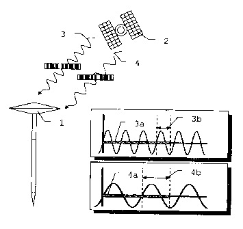
Fig. 3 shows a schematic diagram of a first working
example of the method according to the invention with a
third carrier frequency 5. In this example, the first
carrier frequency 3 and the third carrier frequency 5
now carry a coding, whereas the second carrier
frequency 4 is emitted without a code or the code
cannot or should not be used. According
to the
invention, all three carrier frequencies are now used
with regard to their inherent information. With
respect to the uncoded second carrier frequency 4 or
second carrier frequency 4 measured without coding, the
carrier phase 4b is measured. The third
carrier
frequency 5 on the other hand is analyzed with regard
to the pseudo-path 5a, whereas both pseudo-path 3a and
carrier phase 3b are derived and measured,
respectively, for the first carrier frequency 3. By
using a further carrier frequency, it is possible to
utilize carrier frequencies which are better suitable
also with regard to their physical conditions, for
CA 02608558 2013-07-16
18
example the frequency-dependent ionospheric delay, even
if they do not carry both data, i.e. phase and pseudo-
path. Thus, the flexibility in the choice of useable
carrier frequencies is increased via the method
according to the invention compared with the prior art.
The separability of phase and pseudo-path which is now
possible in principle permits an improvement of the
position determination. By
optimization of the
physical or algorithmic conditions, increased accuracy
can be achieved, for example by choosing a more precise
or smoothed pseudo-path.
Complete separation of phase and pseudo-paths in the
form of a second working example of the method
according to the invention with four carrier
frequencies is shown in Fig. 4. In
this example, the
satellite 2 emits radiation with four different carrier
frequencies. Here,
the first and second carrier
frequencies 3 and 4 are emitted without coding or
measured without coding and the third and fourth
carrier frequencies 5 and 6 are emitted with a code.
The measurement of carrier phases 3b and 4b is effected
for the short-wave and precise first and second carrier
frequencies 3 and 4, whereas a measurement of the
pseudo-paths 5a and 6a is carried out for the
comparatively low-frequency third and fourth carrier
frequencies 5 and 6. By means of the method according
to the invention, it is thus possible to carry out the
measurements in the frequency ranges which are
advantageous in each case.
Independently of this
development, however codings distributed over the
various carrier frequencies can also be evaluated in
any desired manner.
The carrier phase shown in the figures does not
physically correspond exactly to the measurement
actually carried out relative to a reference phase.
CA 02608558 2013-07-16
19
For reasons of clarity, the carrier phases and the
ambiguity term are related directly to the pseudo-path.
In addition, in spite of the chosen system-specific
examples, the method can in principle also be used
according to the invention for any desired generic
satellite-based positioning systems, such as, for
example, GPS, GALILEO or GLONASS. In
particular, the
designations "first" carrier frequency, "second"
carrier frequency, etc. are not necessarily identical
to designations such as L1, L2, etc. For example, the
"first" carrier frequency may also represent L5, the
"second" L1 and the "third" L2.
Furthermore, the
frequency sequences or series chosen purely by way of
example in the figures for the carrier frequencies are
not to be regarded as being limiting.