Note : Les descriptions sont présentées dans la langue officielle dans laquelle elles ont été soumises.
CA 02613605 2007-12-27
WO 2007/003367 PCT/EP2006/006371
METHOD AND APPARATUS FOR DETERMINING THE LOCATION OF A STATIONARY SATELLITE
RECEIVER
The invention refers to a location method and location
apparatus for determining the location of a stationary
satellite receiver having a stationary satellite antenna by
means of ranging packets within satellite payload signals.
Furthermore, the invention refers to a broadcasting method
and a broadcasting apparatus.
A ranging packet in the sense of the present invention is
any packet within a satellite payload signal having a
special PID and being used for ranging purposes.
US 6,864,838 B2 discloses a ranging system and method for
satellites by means of ranging packets within satellite
payload signals. The satellite payload signals are
modulated digital transport stream signals like a DVB-S
signal, wherein the ranging packets are inserted in these
satellite payload signals by way of a time stamp
information. In order to compensate the unknown delay of
the satellite payload signals in the decoding arrangement
of the downlink part it is suggested to use decoding
arrangements of identical structure both in the uplink part
and the downlink part. The corresponding ranging packets
are fed both in the uplink part and the downlink part
through these decoding arrangements before the time stamp
information within the ranging packets is processed by a
corresponding time measurement circuit. It has been found
that this structure provides a high accuracy for performing
CA 02613605 2007-12-27
WO 2007/003367 PCT/EP2006/006371
- 2 -
precise ranging operations with regard to satellites.
However, US 6,864,838 B2 does not disclose the location of
a stationary satellite receiver on earth.
The GPS (Global Positioning System) is a well known system
for providing any point on earth with accurate timing and
ranging information. The basic technique for determining
the GPS coordinates of a GPS receiver is based on a
trilateration solution having three satellites with known
positions. If the distances from each satellite to the
receiver are measured, then the unknown position of the
receiver can be determined. The trilateration solution
corresponds to the ideal case but in practice other
configurations are also applied in order to compensate
is measurement errors or to make use of other position
information available. For example, if the clock bias of
the receiver is unknown a quadrilateration configuration
can be used with four satellites visible from the receiver.
On the other hand, a bilateration configuration might be
applied if a precise local clock is available and if on the
other hand the geodetic reference model of the earth
surface is used as a further coordinate.
GPS receivers are well established and provide a precise
location method on earth. Nevertheless, the invention has
discovered that for some purposes a more simple receiver
instead of a GPS receiver is sufficient. These purposes
apply e.g. to cases where a stationary satellite receiver
has to be located on earth and where a real-time
measurement of the location is not required.
Therefore, it is an object of the invention to provide a
location method for a stationary satellite receiver which
is easy to implement without the need to change the
CA 02613605 2007-12-27
WO 2007/003367 PCT/EP2006/006371
- 3 -
existing system configuration, and to provide a
corresponding location apparatus.
This object is solved by a location method according to
claim 1, a location apparatus according to claim 13, a
broadcasting method according to claim 11 and a
broadcasting apparatus according to claim 20.
The location method according to the invention is a
location method for determining the location of a
stationary satellite receiver having a stationary satellite
antenna by means of ranging packets within satellite
payload signals, wherein said satellite payload signals are
transmitted from one or more earth stations at defined
earth station positions and are relayed from one or more
satellites at different geostationary orbital positions to
be received by the same stationary satellite antenna, said
geostationary orbital positions being controlled in
accordance with a satellite position information by the one
or more earth stations, wherein each ranging packet within
the corresponding satellite payload signal is related to a
time stamp information with regard to the point of time
when the ranging packet was transmitted from the
corresponding earth station, and wherein a plurality of the
ranging packets is detected by the stationary satellite
receiver in the received satellite payload signals, wherein
the relative time differences between the points of time of
detection of the corresponding ranging packets are measured
and wherein the measured relative time differences are
collected and are related to the defined earth station
positions, the time stamp information and the satellite
position information for estimating the location of the
stationary satellite receiver by means of a secondary
condition for resolving the redundancy of the measured
relative time differences.
CA 02613605 2007-12-27
WO 2007/003367 PCT/EP2006/006371
- 4 -
The location apparatus according to the invention is a
location apparatus for determining the location of a
stationary satellite receiver having a stationary satellite
antenna by means of ranging packets within satellite
payload signals, wherein said satellite payload signals are
transmitted from one or more earth stations at defined
earth station positions and are relayed from one or more
satellites at different geostationary orbital positions to
be received by the same stationary satellite antenna, said
geostationary orbital positions being controlled in
accordance with a satellite position information by the one
or more earth stations, comprising: an interface for
receiving time stamp information related to each ranging
packet within the corresponding satellite payload signal
with regard to the point of time when the ranging packet
was transmitted from the corresponding earth station, and
for receiving relative time differences measured in the
stationary satellite receiver between the points of time of
detection of the ranging packets received within said
satellite payload signals by the stationary satellite
receiver, and a location processor for collecting the
measured relative time differences and relating them to the
defined earth station positions, the time stamp information
and the satellite position information for estimating the
location of the stationary satellite receiver by means of a
secondary condition for resolving the redundancy of the
measured relative time differences.
The invention makes it possible to locate stationary
satellite receiver in a broadcast satellite system. Since
the birth of TV in 1923, the core principle of television
has not changed. The broadcast companies determine the
programme whereas the audience has no influence on it. But
a new emerging technique, called interactive TV (iTV)
CA 02613605 2007-12-27
WO 2007/003367 PCT/EP2006/006371
- 5 -
allows the user to manipulate the flow of the programme and
even to participate live in the actual broadcast. Those
systems use a terrestrial or satellite back-channel to send
user data back to providers of the interactive services.
Typical applications for iTV are interactive advertisement,
home shopping, video on demand (VoD) sports betting and
games.
The invention realises a cost-efficient localization
io structure in an existing satellite broadcast system with a
minimum of additional installations at the user side. In
contrast to a GPS system, which requires additional
hardware components in a commercial satellite TV receiver,
the invention proposes a method which makes use of the
i5 already existing stationary satellite antenna of the user.
The principle is to measure the time difference of arrival
of satellites at different geostationary orbital positions
but which are narrowly enough co-located so that the
downlink signals of the co-located satellites can still be
20 received by the same stationary satellite antenna of the
stationary satellite receiver. Nowadays, satellites are co-
located within a single geostationary orbital slot in order
to enable an optimum use of the available orbital slots and
of the limited frequency spectrum. To the users on ground,
25 the co-located satellites appear as a single satellite with
a large capacity. The interference between the co-located
satellites is avoided by making the satellites transmit
signals which are polarized orthogonal and/or which have a
different frequency spectrum.
Usually, the stationary satellite antenna for receiving
satellite payload signals from geostationary orbital
positions is a satellite dish having one low-noise block
downconverter (LNB) which is capable of receiving the
satellite payload signals from one geostationary orbital
CA 02613605 2007-12-27
WO 2007/003367 PCT/EP2006/006371
- 6 -
slot. The invention enables a resolution between these
geostationary orbital positions within one geostationary
orbital slot of as narrow as 0.10 or even below.
However, there are also satellite dishes available having
two or more LNBs installed at different focal points of the
dish so that satellite payload signals from different
geostationary orbital slots can be received. These
satellite dishes can also be used according to the
io invention providing a better resolution of the measured
relative time differences due to a larger spacing between
the geostationary orbital positions.
A further cognition of the invention is the fact that the
is relative time differences between the points of time of
detection of corresponding ranging packets of two satellite
payload signals deriving from different satellite positions
are measured. Hence, it is not necessary for the stationary
satellite receiver to know the absolute GPS time but it is
20 merely necessary to provide a precise and stable clock for
carrying out the measurement of said relative time
differences which are in the range of 200 ps, wherein the
duration of two consecutive detections of two ranging
packets in two different satellite payload signals is in
25 the order of 1 second due to the necessary switchover from
one satellite payload signal to the other satellite payload
signal. This makes it possible to refrain from expensive
time measurement equipment within the stationary satellite
receiver. Rather, between the measurements it is possible
30 to adjust the frequency of the local oscillator of the
stationary satellite receiver to a reference frequency
which can be extracted from the satellite payload signal.
Such a reference frequency is e.g. provided by the PCR
values of a MPEG data stream. A corresponding apparatus and
35 method for extracting such a reference frequency out of a
CA 02613605 2007-12-27
WO 2007/003367 PCT/EP2006/006371
- 7 -
satellite payload signal is e.g. disclosed in EP 1030464
Bl.
The measured relative time differences are collected for a
later estimation of the location of the stationary
satellite receiver. As soon as enough relative time
differences have been collected, the relative time
differences are related within a system of equations to the
other available information in the system which are the
defined earth station positions of the one or more earth
stations, the time stamp information with regard to the
point of time when each ranging packet was transmitted from
the corresponding earth station and the satellite position
information with regard to the corresponding satellite
positions from which the corresponding ranging packets were
relayed. The result is a system of equations which is
overdetermined but which can be solved by means of a
secondary condition for resolving the redundancy of the
measured relative time differences.
According to a further aspect of the invention the
satellite payload signals are DVB-S data streams
transmitted by the one or more earth stations. Hence, the
existing DVB-S front-end of the satellite receiver can be
used wherein at the same time the data bandwidth occupied
by the ranging packets is negligible small and does not
affect the conventional DVB-S data stream.
According to a further aspect of the invention the movement
of the one or more satellites is used to refer to different
geostationary orbital positions of the one or more
satellites. Thereby, in principle one satellite is
sufficient to provide all the necessary location
information at the satellite receiver. However, according
to a preferred aspect at least two satellites are co-
CA 02613605 2007-12-27
WO 2007/003367 PCT/EP2006/006371
- 8 -
located within a geostationary orbital slot by which the
information of one measurement of one relative time
difference can be provided at once. As soon as the position
of at least one of said two satellites changes, a further
measurement of another relative time difference can be
taken. The same applies to a configuration of more than two
satellites where it can be switched in a suitable manner
between the corresponding satellite payload signals to
achieve the needed measurements of the relative time
differences. Furthermore, in order to reduce one unknown
variable of the location of the stationary satellite
receiver the geodetic model of the earth can be used as a
further position information.
is The ranging packets can be identified by a packet sequence
information which is unambiguously related to the
corresponding defined earth station positions, the time
stamp information and the satellite position information.
According to a further aspect of the invention the
estimation of the location of the satellite receiver is
carried out in said satellite receiver for which purpose
the ranging packets carry the necessary time stamp
information and the necessary satellite position
information besides the packet sequence information.
According to another aspect of the invention one earth
station is provided, wherein the estimation of the location
of the satellite receiver is carried out in said earth
station. For this purpose the measured relative time
differences together with the corresponding packet sequence
information are returned from the stationary satellite
receiver to said earth station. In general, it goes without
saying that the estimation procedure of the location of the
satellite receiver is not bound to any specific location or
CA 02613605 2007-12-27
WO 2007/003367 PCT/EP2006/006371
- 9 -
position but can be carried out at any place which is
suitable for this purpose as soon as all the necessary
information has been transmitted to this place.
s According to a further aspect of the invention the
secondary condition for the estimation of the location of
the stationary satellite receiver is based on a least mean
squares algorithm. According to the invention, the amount
of the collected data will exceed the unknown variables so
that the resulting system of equations is overdetermined.
This redundancy can be resolved by the condition that the
error variation of the estimated solution with regard to
the single collected data should be minimized. The
corresponding solution can be found iteratively by a
recursive algorithm feeding consecutively new data to the
algorithm or can be found for one data block of collected
data by solving the resulting system of equations.
According to a further aspect of the invention, reference
values are used for improving the location estimation of
the stationary satellite receiver, wherein said reference
values are provided by one or more reference receiver
having known positions and receiving the satellite payload
signals.
A reference receiver, which can either be positioned within
the ground station or somewhere else, allows to measure
either reception time of the ranging packets in case the
reference receiver is connected to a GPS time- and
frequency source, or to measure the time difference of two
consecutive ranging packets in case the reference receiver
is only provided with a free running oscillator. The
principle is to compare these measurement results with a
theoretical value, which can be obtained based on the known
positions of the corresponding earth station, the
CA 02613605 2007-12-27
WO 2007/003367 PCT/EP2006/006371
- 10 -
corresponding satellite and the reference receiver itself.
The delays which are compensated in this way are for
example delays in the ground station which are still
unknown, unknown delays in the satellite transponders etc.
As already mentioned above, the invention makes it possible
to provide location based services in an interactive TV
environment.
Hence, another method according to the invention is a
broadcasting method for broadcasting a plurality of
satellite payload signals from an earth station via at
least one satellite to a plurality of stationary satellite
receiver, wherein the payloads of each satellite payload
signal are controlled in accordance with the location of
each of said plurality of stationary satellite receiver
determined by a location method as described above.
Furthermore, another apparatus according to the invention
is a broadcasting apparatus for broadcasting a plurality of
satellite payload signals from an earth station via at
least one satellite to a plurality of stationary satellite
receiver, wherein the payloads of each satellite payload
signal are controlled in accordance with the location of
each of said plurality of stationary satellite receiver
determined by a location apparatus as described above.
The payloads of each satellite payload signal can be
controlled in accordance with the location of the
stationary satellite receiver by a corresponding marker
which is introduced in the payloads at the earth station
before transmitting the payloads. Although the payloads are
broadcast so that all payloads can be received by all
stationary satellite receivers, a filter can be provided in
each stationary satellite receiver which allows to select a
CA 02613605 2007-12-27
WO 2007/003367 PCT/EP2006/006371
- 11 -
subset of the received payloads depending on the marker and
thus depending on the estimated location.
Another possibility is to provide the at least one
satellite with a plurality of spot beam antennas, wherein
the corresponding marker, which is introduced in the
payloads at the earth station before transmitting the
payloads, allows the at least one satellite to switch a
subset of the received payloads to one of the spot beam
io antennas depending on the marker and thus depending on the
estimated location.
Eventually, it is also possible to have a combination of a
spot beam configuration and the filtering at the stationary
satellite receiver.
The invention will now be described by way of an example
and with reference to the accompanying drawings in which
Fig. 1 shows the uplink part of a satellite broadcast
system according to the invention,
Fig. 2 shows a schematic of the measurement board of a
stationary satellite receiver according to the
invention,
Fig. 3 shows a satellite broadcast system for
determining the location of a stationary
satellite receiver according to the invention,
Fig. 4 shows a first type of a reference receiver for
improving the location estimation according to
the invention,
CA 02613605 2007-12-27
WO 2007/003367 PCT/EP2006/006371
- 12 -
Fig. 5 shows a second type of a reference receiver for
improving the location estimation according to
the invention, and
Fig. 6 shows a third type of a reference receiver for
improving the location estimation according to
the invention.
Fig. 1 shows the uplink part of a satellite broadcast
system according to the invention. The task of the uplink
part is to provide as an uplink satellite payload signals
and to insert ranging packets in said satellite payload
signals. Besides being able to cope with unidirectional
satellite payload signals, the satellite could also include
capabilities to perform bidirectional communications. This
is of particular interest when dealing with interactive TV
(iTV) which is an application of the present invention.
The satellite payload signals could for example be of the
type of a DVB-S satellite payload signal. Each ranging
packet has a packet sequence information and is related to
a time stamp information and a satellite position
information. If the location estimation takes place in the
stationary satellite receiver, the packet sequence
information, the time stamp information and the satellite
position information are carried with the ranging packets.
If, on the other hand, the location estimation takes place
in the earth station, it is sufficient that each ranging
packet carries only the packet sequence information which
is related to the corresponding time stamp information and
the satellite position information stored in the earth
station.
The packet sequence information corresponds to the
continuity counter of the usual DVB-S satellite payload
CA 02613605 2007-12-27
WO 2007/003367 PCT/EP2006/006371
- 13 -
signal but is extended such that the packet sequence
information remains unambiguous without reaching its
maximum value within one procedure of position estimation
of a specific stationary satellite receiver.
The time stamp information provides for each ranging packet
a time stamp which corresponds to the moment of time when
the ranging packet was transmitted from the uplink station.
io The satellite position information corresponds to the
position of the satellite to which a ranging packet is sent
at the moment of time when the ranging packet was
transmitted from the uplink station. This satellite
position information is available in the corresponding
i.5 earth station which controls the position of the satellite.
The ranging packets to be inserted are generated by the
ranging packet generator 101 and are sent to the ranging
information insertion 102, where the payload of the ranging
20 packet is manipulated. Hence, at the ranging information
insertion 102 the packet sequence information for the
corresponding packet is inserted. Furthermore, the time
stamp information of the previous ranging packet is also
available in the ranging information insertion 102 and is
25 inserted in the present ranging packet. If more than one
satellite is involved in the measurements, all available
time stamp information of the previous ranging packets
which were sent in parallel to the corresponding satellites
are inserted in the present ranging packet so that the
30 stationary satellite receiver is free of choosing one of
these time stamp information which is necessary for the
location estimation.
The ranging packet modified in this way is sent to the MUX
35 matrix 103. The MUX matrix 103 combines different data
CA 02613605 2007-12-27
WO 2007/003367 PCT/EP2006/006371
- 14 -
sources and merges them in one satellite payload signal.
After the uplink equipment consisting of uplink 104 and
uplink 105 the satellite payload signals are split in the
splitters 114 and 115. The satellite payload signals 116,
117 are transmitted via the antennas 110, 111 to the
satellites 112, 113, whereas the satellite payload signals
118, 119 are converted from the transmission frequency to a
lower intermediate frequency by the block down converter
106, 107 and are fed to the transmission time measurement
io systems 108, 109.
The transmission time measurement systems 108, 109 allow to
measure the moment of time when a ranging packet has
already passed the MUX matrix, so that the stochastically
produced delays of the MUX matrix are not taken into
account by this measurement. Although the actual moment of
time when a ranging packet leaves the uplink equipment
cannot be measured by the transmission time measurement
systems 108, 109, the time stamp information provided by
the transmission time measurement systems 108, 109 still
can be used for determining the relative time differences
of two satellite payload signals as long as the delays of
the splitters 114, 115 and the block down converters 106,
107 are nearly identical.
As soon as the transmission time of one packet has been
determined by one of the transmission time measurement
systems 108, 109, the corresponding time stamp information
will be inserted in a subsequent ranging packet, since the
present packet has already left the uplink part.
Even though the previous description referred to one earth
station only, it should be mentioned that more than one
earth station can be employed according to the invention.
In this case, a time- and frequency-synchronisation has to
CA 02613605 2007-12-27
WO 2007/003367 PCT/EP2006/006371
- 15 -
be performed between the individual earth stations. In any
case it is necessary to know the precise position of the
earth station on earth.
The position of the satellites is also controlled by the
earth station, e.g. by sending corresponding satellite
position information via the earth stations to the
satellites.
Fig. 2 shows a schematic of the measurement board of a
stationary satellite receiver according to the invention.
The measurement board 201 is controlling the DVB-S receiver
202, is monitoring the digital output stream (satellite
payload signal) and is communicating with the PC via a
serial port 203.
For economical reasons the measurement board is not time
synchronized with a GPS clock. However, the received DVB-S
data stream of the satellite payload signals allows to
control a free running oscillator which drives the counter
204 of the measurement board such that only a time offset
with respect to the GPS clock is present. For this purpose,
consecutive incoming ranging packets having a time stamp
information or the clock reference of the DVB-S payload
packets are used as time reference. Knowing the time in-
between two ranging packets and the change of the free
running oscillator within this time, it is possible to
estimate the average frequency for,[n] over this time.
Because of the time offset between the counter 204 and the
GPS clock, it is not possible to compute the range to a
satellite directly. However, the relative time difference
between the points of time of detection of the
corresponding time stamp information or of the
corresponding packet sequence information in two satellite
CA 02613605 2007-12-27
WO 2007/003367 PCT/EP2006/006371
- 16 -
payload signals deriving from two different satellite
positions can be computed in which case this time offset is
eliminated.
s The counter 204 is triggered by the packet identifier (PID)
filter 205, checking satellite payload signals for ranging
packets with the right PID. Those ranging packets are
latched into the FIFO 206.
For determining the relative time difference between two
ranging packets, two satellite payload signals have to be
received. However, because the receiver 202 has just one
tuner, it is not possible to receive two satellite payload
signals simultaneously. Therefore, the relative time
difference can only be measured of two consecutive ranging
packets after having switched to the other satellite
payload signal. Assuming that the system - especially the
satellite positions - has not changed in between, the
results will, however, be the same.
Therefore, in order to perform a measurement, a ranging
packet is received from a first satellite, and then the
receiver is changed to receive a ranging packet from the
second satellite. This change is performed periodically
after a certain number of ranging packets.
In principle, there is a loss of accuracy caused by the
inherent stochastic delays of the receiver, by the movement
of the satellites and by the error of the frequency
estimation.
The errors induced by the stochastic delay of the receiver
can be reduced by an averaging effect when applying the
algorithm for estimating the location of the receiver.
Knowing the movement of the satellites, it is furthermore
CA 02613605 2007-12-27
WO 2007/003367 PCT/EP2006/006371
- 17 -
possible to correct the error caused by the movement of the
satellites during the post processing.
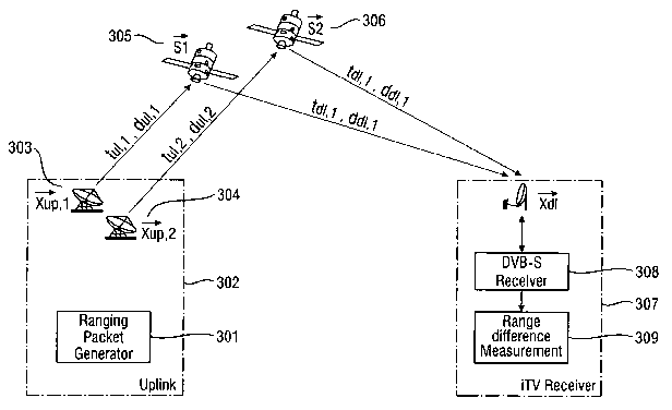
Fig. 3 shows a satellite broadcast system for determining
the location of a stationary satellite receiver according
to the invention. The ranging packet generator 301 within
the uplink 302 provides DVB-S ranging packets with a
certain PID. Those ranging packets are inserted into the
DVB-S satellite payload signal, as explained in the
description relating to Fig. 1, and transmitted via the
earth stations 303 and 304 to the satellites 305 and 306.
In order to be in line of sight from the iTV receiver 307
(stationary satellite receiver) without the need of
is performing re-adjustments of the latter, the satellites
have to be co-located within the same geostationary orbital
position, i.e. be positioned within the same station
keeping box.
The ranging packets are relayed by the satellites and are
sent to a stationary satellite receiver 307. The satellite
receiver 307 consists of a down-converter (like LNB/Mono-
block), a DVB-S receiver 308 delivering the satellite
payload signal and the range difference measurement 309.
The range difference measurement 309 measures the ranging
packet arrival time (PAT) of the inserted ranging packets
and computes the range difference.
The difference of the distances of the two DVB-S satellite
links Opmeas can be calculated as follows. Using the notation
as given in Fig. 3, that is:
dõ1,1 distance on uplink path to satellite 1
dal,l distance on downlink path from satellite 1
du1,2 distance on uplink path to satellite 2
CA 02613605 2007-12-27
WO 2007/003367 PCT/EP2006/006371
- 18 -
ddl,2 distance on downlink path from satellite 2
Sl position of satellite Satl
S2 position of satellite Sat2
xdl downlink position
xõp uplink position
APmeas can be written as:
OPnieas-ddl,2 +dul,2 -(ddl,l +dul,l/-I'xdl -S2I+Ixup -S2I Odl -SI I + IXup -SI
I) (1)
wherein Apmeas is proportional to the measured relative time
difference, having the speed of light as the proportional
factor.
The technique used to estimate the relative time difference
is inserting ranging packets with a certain ID (PID), as
shown in Fig. 1, into the DVB-S satellite payload signal of
both satellite links and measuring the transmission and
reception time. Even though transmission and reception time
are not measured in the same time frame, i.e. an offset is
present, the relative time difference can be determined
with this information.
The use of DVB-S ranging packets allows to use the existing
link structures without the installation of additional
equipment at the receiver side and avoids the transmission
of additional signals like spread spectrum signals,
interfering with the main signal.
Existing receivers are mainly single feed systems pointing
to an exclusive geostationary orbital position. Usage of
co-located geosynchronous satellites allows the reception
of different satellites with said single feed antennas but
the resulting satellite geometry is poor.
CA 02613605 2007-12-27
WO 2007/003367 PCT/EP2006/006371
- 19 -
Equation 1 shows the non-linear relationship between the
range difference opmeas and the downlink position Xdl. This
equation can be linearised by using a tailor approximation
around an approximated reference point Xref:
X d i = X , . e j + .L (2)
The resulting linear equation for a single range difference
measurement is:
x r
0/~meas =C1~uR2 - L~uP,I + ej - S2 Xrej - Sl CTX ( 3)
Ixrej - S2I I xrej - Sl I
Xfej - S2 xrej - Sl
_ ' ~ = OPmeas= - duP,2 + duP,1 (4)
Ixrej - S2I Ixrej - Sl I
bi
Ai
To perform a triangulation of the terminal position, at
least 3 different measurements are needed. To reduce the
level of unknown variables, it is assumed that the user
terminal is on the surface of the earth and force the
position of the user terminal at a certain height over a
geodetic model of the earth. The used earth model is the
Geodetic Reference System 1980 (GSR80).
Even adding the height information, there is still a lack
of a third equation. To achieve a sufficient number of
equations, the movement of the geosynchronous satellites is
utilized to perform multiple measurements over time and to
realize different satellite constellations. However, due to
the minimal motion of the satellites it might be necessary
to apply observation periods up to several hours. The
CA 02613605 2007-12-27
WO 2007/003367 PCT/EP2006/006371
- 20 -
stopping criteria for this process is the convergence of
the estimated location of the stationary satellite receiver
within a predetermined boundary. This means, once the
estimated location does not change anymore significantly
from one measurement to the next measurement, the location
is considered to be sufficiently accurate.
These stopping criteria can also be calculated on the basis
of the single available values without the need of a
io running estimation of the location of the stationary
satellite receiver if just the noise levels of the single
values are known. The knowledge of the system and the noise
levels of the single values make it possible to predict the
uncertainty of the position estimation before actually
carrying out the estimation algorithm. If the predicted
uncertainty is sufficiently small, the collection of the
measurements can be stopped.
Furthermore, said prediction of the uncertainty of the
position estimation can also be used in order to find out
the optimal satellite constellation of the co-located
satellites with regard to the present measurement. Hence,
if there are more than two co-located satellites within one
single orbit slot, it is possible to choose always those
two satellites for measuring the relative time difference
which yield the lowest predicted uncertainty of the
position estimation.
Eventually, by using said prediction of the uncertainty of
the position estimation it is also possible to estimate in
advance the period of time which is necessary to collect
enough data for obtaining a position estimation within a
certain error boundary.
CA 02613605 2007-12-27
WO 2007/003367 PCT/EP2006/006371
- 21 -
Practical measurements have shown that the attainable
accuracy of the position estimation based on co-located
satellites within one station keeping box is about 1,5 km -
3,0 km.
The estimation of the position is based on several range
difference measurements, described in equation 4 and can be
combined in one system of equations:
A,
A,
d'x -(b, b2 ... bn-, bn ) r* -A ci'x = b (5)
An
A
This matrix equation is over determined and can be solved
in the meaning of minimum mean square error, using the
generalized pseudo inverse A of the visibility matrix A.
A-=CATAY'AT (6)
d"x=A-=b (7)
Finally, it should be noted, that the estimation of the
location could either be performed within the stationary
satellite receiver or within the earth station. In the
first case it is necessary to send the time stamp
information for each ranging packet together with the
satellite position information of the corresponding
satellite and the defined position of the earth station
with the ranging packet itself. This case is suitable for
receivers which have no return channel to the earth
station. However, additional processing power has to be
CA 02613605 2007-12-27
WO 2007/003367 PCT/EP2006/006371
- 22 -
provided in the corresponding receiver to perform the
necessary calculations.
In the second case it is sufficient that the packet
sequence information of each packet is related to the
corresponding time stamp information stored in the earth
station, wherein the measured relative time differences are
returned from the stationary receiver to the earth station.
Performing the position computation at the earth station
io reduces the necessary processing power at each stationary
receiver and enables a low-cost implementation of the
position estimation at each stationary receiver. It is
merely necessary to have a low-bit-rate return channel in
order to send the time-stamping information to the earth
is station where the satellite position information is known
and where then the resulting calculations can be carried
out.
While a method was given in the description of Fig. 1 by
20 which the so-called insertion time could be determined and
therefore taken account of in the subsequent estimation of
the location, some measurement inaccuracies are still
present within the system. Such measurement inaccuracies
could include delays in the ground station which are still
25 unknown, unknown delays in the satellite transponders,
errors depending on the measurement method (It was stated,
that the measurement using consecutive ranging packets
relies on the - often not applicable - assumption of
stationary satellites.), and errors in the satellite
30 positions - all factors which can hardly be taken care of
by considering only the insertion time.
To address this problem one or more reference receiver can
be added to the location determination system as described
CA 02613605 2007-12-27
WO 2007/003367 PCT/EP2006/006371
- 23 -
above. Each reference receiver will improve the resulting
accuracy and will also shorten the measurement period.
A reference receiver is a fixed installed receiver with
known position on earth. The reference receiver is
measuring constantly the range difference between the
different positions of a satellite and/or the positions of
different satellites. The fundamental idea is to compare
the time delay of arrival (TDOA) measured in this way with
io a theoretical value for the TDOA, which can be obtained
based on the known positions of the earth station(s), the
satellite(s) and the reference receiver.
By computing the difference between a theoretical model and
the measurements, a compensation value can be determined.
This compensation value can be employed when estimating the
location of the stationary satellite receiver. In this way
measurement inaccuracies contained in the compensation
value can be eliminated or at least reduced in further
location determinations. Due to this improvement in the
accuracy when estimating the location, the required number
of measurements will be reduced as well, i.e. the estimated
location converges faster towards the actual location.
As soon as the position information of each satellite
receiver is known (at the satellite receiver, at the earth
station, or at both locations) there are various
possibilities to enhance the features of the overall
broadcasting system. In the following, some of these
possibilities and applications are described by way of
example.
- Continuous monitoring of the alignment of the satellite
dish
CA 02613605 2007-12-27
WO 2007/003367 PCT/EP2006/006371
- 24 -
If the position of the satellite receiver is known to the
receiver itself it is possible for the receiver to
calculate the optimum alignment angle to the corresponding
satellite. By means of corresponding sensors the actual
alignment angle can be monitored and can be compared with
the desired alignment angle. During setup or in case of an
external impact the actual alignment angle can be corrected
to reach again the desired alignment angle.
- Enhanced conditional access and enhanced authentication
Some pay-TV channels require a login of the user which
means that the user is registered at the earth station. The
knowledge of the user's position enables to check if the
is user is at the right position during login. If the position
is not the registered position the login can be denied.
- Market research
The known positions of the satellite receivers can be used
to obtain spatial information of the audience which is
spectating currently the TV content.
- Location based services in TV or interactive TV
It is possible to provide a regional broadcast of the TV
content such that only users in predetermined regions are
able to receive the corresponding TV content. This offers a
vast variety of new applications like regional
advertisement, regional news, or automatic language
selection. It is possible to perform a local right
management for TV content which depends on a set of
specified countries, like the rights to broadcast a
football game. The invention makes it possible to suppress
the reception of the TV content in regions for which no
CA 02613605 2007-12-27
WO 2007/003367 PCT/EP2006/006371
- 25 -
rights are obtained with regard to the corresponding
content. Other applications are locally restricted services
for such TV content which is allowed only in specific
countries like sport bets or gambling. For interactive TV
it is possible to provide chat rooms with people nearby or
to provide a selection of local shops where online shopping
can be performed.
The technical realisation of the location based services is
io already well-known. For example, a spot beam configuration
can be used, local PID filtering can be applied or a
combination of both is possible.
For a spot beam configuration it is necessary to have a
i5 satellite transponder with multiple spot-beams or to have
multiple satellites with inter-satellite links. The earth
station knows the position of each satellite receiver and
decides the routing of the content according to the
position of each receiver. The DVB-transport stream of each
20 payload contains information as to which spot beam the
payload has to be sent on the downlink. The satellite
transponder switches then the received payloads of the
uplink to the various spot beams depending on this
information. All spot beams which have a footprint covering
25 a specific satellite receiver can transmit payloads to said
satellite receiver. However, said satellite receiver is not
able to receive payloads of other spot beams.
Another possibility is to apply local PID filtering within
30 each satellite receiver. For this purpose, each satellite
receiver has a filter which filters only those payloads
from the downlink which correspond to the regional key of
said satellite receiver. The key depends on the location of
the satellite receiver and may be stored permanently in the
35 satellite receiver by the system during installation and
CA 02613605 2007-12-27
WO 2007/003367 PCT/EP2006/006371
- 26 -
setup. For example, the footprint of the satellite can be
divided into geographic sectors. Each satellite receiver
has also the information available about these sectors and
decides according to the own position in which sector it is
situated. When transmitting a TV content, each payload
contains information as in which sector the payload is
allowed to be received and the satellite receiver has a
filter which filters only those payloads from the downlink
which correspond to the sector of the receiver.
The regional keys with the corresponding local information
are also known to the earth station which supplies each
payload of the uplink with the suitable key for location
based services. It is also possible that the regional key
within the satellite receiver is updated by the earth
station before a new transmission is started. For this
purpose each satellite receiver is addressable by a unique
ID, wherein the earth station sends a clearance signal with
the corresponding key before transmitting the content. The
clearance signal could also be an encryption code so that
the satellite receiver can perform a decryption of the
signal.
Fig. 4 to Fig. 6 show three different types of reference
receivers for improving the location estimation according
to the invention. These differ in the installation costs,
the resulting accuracy and the necessary efforts.
Fig. 4 shows a first type of a reference receiver for
improving the location estimation according to the
invention. This type of the reference receiver 420 is
performing real range measurements for both satellites 412
and 413 using a reception time measurement system 421 that
is synchronized to the transmission time measurement
systems 408 and 409 of the earth station 422.
CA 02613605 2007-12-27
WO 2007/003367 PCT/EP2006/006371
- 27 -
The setup of the reference receiver 420 consists of a
standard dish with a LNB 423, a power splitter 424, a
reception time measurement system 421, and a PC 425.
The IF signal from the LNB 423 is supplied via the power
splitter 424 to both ranging receivers (RR1, RR2) of the
reception time measurement system 421.
The reception time measurement system 421 uses the same
time- and frequency source 426 as the ground station 422 to
measure the reception time of the ranging packets generated
by the ranging packet generation 401 at the uplink station
422. Therefore, the reference receiver 420 can be
is positioned directly at the earth station 422. The PC 425 is
collecting the data of the reference receiver 420 and the
timestamp information of the uplink station 422.
Knowing the uplink time and the reception time, it is
possible to compute the range and the range difference to
both satellites 412 and 413. Considering the known
positions of the satellites 412 and 413, it is possible to
compute the difference between the measured range
difference and the theoretical range difference.
By measuring the uplink and the reception time, it is
possible to compute the distance to both satellites 412 and
413 and the respective range difference very accurately. By
comparing these measurements with a theoretical model, the
compensation value caused by the various factors as
mentioned above can be determined. It is also possible to
check the satellite ephemeris and its interpolation.
Fig. 5 shows a second type of a reference receiver for
improving the location estimation according to the
CA 02613605 2007-12-27
WO 2007/003367 PCT/EP2006/006371
- 28 -
invention. This type is using a separate GPS time and
frequency source 501 to apply pseudo range measurements for
both satellites 502 and 503 or for two positions of one
satellite. Due to the separate GPS time and frequency
source 501 there is no need to position the reference
receiver within the ground station. However, the resulting
accuracy is not as high as that of the first type according
to Fig. 4, because there are synchronization errors between
the clock at the uplink station and this local reference
io receiver.
A measurement board 504 as described with reference to Fig.
2 is used to extract the uplink timestamps out of the
ranging packets once the signal passed through the
receiver, in this case a DVB-s receiver 505.
The reference receiver consists of standard dish with a LNB
506, a power splitter 507, a reception time measurement
system 508, a GPS time- and frequency source 501, a DVB-S
receiver 505, a measurement board 504 and a PC 509.
The L-Band signal of the LNB 506 is distributed via a power
splitter 507 to both ranging receivers of the reception
time measurement system 508 and to a receiver 505 with a
measurement board 504. A GPS time- and frequency source 501
delivers the time and frequency reference for the reception
time measurement system 508 and a PC 509 is collecting all
the data.
The ranging receivers are measuring the reception time of
the ranging packets, generated by the ranging packet
generation at the uplink side. The DVB-S receiver 505 with
measurement board 504 is receiving the ranging packets and
reads out the uplink time stamp information in the payload
CA 02613605 2007-12-27
WO 2007/003367 PCT/EP2006/006371
- 29 -
of the ranging packets, inserted by the ranging packet
generation at the uplink side.
Even though the uplink time and the reception time have
been measured with unsynchronized clocks, a pseudo range to
both satellites 502 and 503 and a pseudo range difference
can be calculated. Noticeably, the resulting accuracy of
the system is still quite good.
By comparing the results with the theoretical model of the
system, again a compensation value can be determined.
Eventually, the satellite ephemeris and its interpolation
can be verified.
is Fig. 6 shows a third type of a reference receiver for
improving the location estimation according to the
invention. This type is using a DVB-S receiver 601 with a
measurement board 602, to measure the pseudo range
difference of both satellites 603 and 604 or two positions
of one satellite. A measurement board 602 as described with
reference to Fig. 2 is employed for this purpose.
This reference receiver is using the same techniques, as
the stationary satellite receiver according to the
invention. It is measuring the time difference of two
consecutive ranging packets with its internal free running
clock within the measurement board 602. The uplink time of
the ranging packets is extracted from the payload of the
ranging packets, in order to compute the pseudo range
difference.
It was mentioned before, that the accuracy of such a system
is limited, due to the stochastic delays in the reference
receiver and the time discretization noise. However, an
improvement of the measurement results can be achieved, by
CA 02613605 2007-12-27
WO 2007/003367 PCT/EP2006/006371
- 30 -
considering a longer measurement period and using a more
stable oscillator.
This reference receiver consists of a standard dish with
s LNB 605, a DVB-S receiver 601 with measurement board 602, a
stable oscillator (XCO) 606 and a PC 607.
Compared to the first and second types of the reference
receiver, the accuracy when determining the compensation
io value is lower. However, this approach represents a cheaper
method to obtain a compensation factor at all. The third
type of reference receiver can be positioned at any known
location.