Note : Les descriptions sont présentées dans la langue officielle dans laquelle elles ont été soumises.
CA 02613800 2007!12-05
202182 PEL
2007-03-01
TITLE
SUBSURFACE IMAGING RADAR
TECHNICAL FIELD
The invention relates to a subsurface imaging radar device comprising a
transmitting unit and a receiving unit, the transmitting unit being arranged
to
transmit a first radio wave signal in a lobe towards a selected ground area at
a selected elevation angle 0 to the ground area. The invention also refers to
a method for a subsurface imaging radar device.
BACKGROUND ART
In the arid and open areas of many current conflicts burying objects is a
commonplace element of military tactics. The rationale is that this is often
the
single way of concealing them, and very simple to do in e.g. sandy terrain.
These objects can be mines, concealed weapons or tunnels and bunkers.
Correspondingly there is a strong requirement for efficient means of detecting
these types of buried objects.
The circumstances and purposes for buried object detection vary. Still
surveillance capacity linked to a high probability of detection is a general
concern. For instance a military transport en route along a road must posses
a possibility to detect the mines which may harm it when traveling at some
reasonable speed. In contrast after a peace treaty there is very strong
requirement for efficient demining requiring all mines to be found and
deactivated. They may be spread over large areas, and not always in a
fashion which is well controlled. In this case there is no real time demand
though the surveillance task is often so large that surveillance capacity must
be large. Searching for concealed weapons, is often delimited to certain
areas and may not have any immediate real time requirement. However
there may be a strong pressure to obtain results within definite deadlines so
surveillance capacity is a concern in this case too.
CA 02613800 2007-12-05
2
An emerging application area is the restoration of former military storage and
training areas to civilian land use. The areas can be severely polluted by
unexploded ordonance, and harmful waste. The location of waste deposits
may have been forgotten through the dramatic organizational changes in e.g.
Eastern Europe.
When surveillance requirements are large the use of handheld mine
detection devices would be inefficient. Also self-moving detection devices
depending on magnetostatic or electrostatic effects (thus measuring the
ground permeability or dielectricity constant) have low surveillance capacity.
The reason is that static fields decline at short ranges, calling for careful
and
slow movements in the detection process. In contrast, radar is based on
electromagnetic radiation. Since range attenuation of electromagnetic
radiation is smaller than that of electrostatic fields, radar seems to be the
principle to be preferred for large coverage subsurface object detection.
Subsurface objects may be small, and their signatures very weak. Therefore
a detection device must sense only a small portion of the ground where the
disturbance of the ground due to the presence of an object will be relatively
noticeable. A problem with radar operating at larger surveillance ranges is
therefore how to obtain sufficient resolution, isolating small volumes of the
ground. The principle of synthetic aperture radar, SAR, is a well-known
method to obtain high 2-dimensional resolution of the ground surface.
A Synthetic Aperture Radar, SAR, can be used from the ground and from the
air. An airborne SAR produces two-dimensional images perpendicular to the
aircraft path of flight. One dimension in the image is called range (or cross
track) and is a measure of the "line-of-sight" distance from the radar to the
target. Range measurement and resolution are achieved in synthetic
aperture radar in the same manner as most other radars: Range is
determined by precisely measuring the time from transmission of a pulse to
receiving the echo from a target and, in the simplest SAR, range resolution is
CA 02613800 2007-12-05
3
determined by the transmitted pulse width, i.e. narrow pulses yield fine range
resolution.
The other dimension is called azimuth (or along track) and is perpendicular to
range over the ground surface. It is the ability of SAR to produce relatively
fine azimuth resolution that differentiates it from other radars. To obtain
fine
azimuth resolution, a physically large antenna is needed to focus the
transmitted and received energy into a sharp beam. The sharpness of the
beam defines the azimuth resolution. Similarly, optical systems, such as
telescopes, require large apertures (mirrors or lenses which are analogous to
the radar antenna) to obtain fine imaging resolution. Since SARs are much
lower in frequency than optical systems, even moderate SAR resolutions
require an antenna physically larger than can be practically carried by an
airborne platform: antenna lengths several hundred meters long are often
required. However, airborne radar could collect data while flying this
distance
and then process the data as if it came from a physically long antenna. The
distance the aircraft flies in synthesizing the antenna is known as the
synthetic aperture. A narrow synthetic beamwidth results from the relatively
long synthetic aperture, which yields finer resolution than is possible from a
smaller physical antenna.
While this section attempts to provide an intuitive understanding, SARs are
not as simple as described above. For even moderate azimuth resolutions, a
target's range to each location on the synthetic aperture changes along the
synthetic aperture. In SAR the energy reflected from the target must be
"mathematically focused" to compensate for the range dependence across
the aperture prior to image formation. When the aperture is large the SAR
can give resolution near the radar wavelength which gives a sensitive focus
and objects will vanish in the SAR image unless properly focused.
However, the previously known SAR cannot be used for underground
detection since the electromagnetic energy cannot penetrate the ground
sufficiently, but is reflected over the surface.
CA 02613800 2007-12-05
4
Hence, there remains a need for an improved radar that can be used for
underground imaging.
DISCLOSURE OF INVENTION
The invention relates to a subsurface imaging radar device comprising a
transmitting unit and a receiving unit. The transmitting unit being arranged
to
transmit a first radio wave signal in a lobe towards a selected ground area at
a selected elevation angle 0 close to a horizontal plane in the ground area so
that a significant part of the energy in a vertically polarized signal, with
reference to the ground, is trapped in a surface wave mode which is
successively tapped by refraction into the ground area. Here the ground area
is so small that the curvature of the earth can be disregarded so that the
ground area can be approximated with a horizontal plane.
It is advantageous if at least 10 % of the energy of the first signal is
refracted
into the ground area, since the radar device according to the invention has
been proven to perform well for when at least 10 % of the energy of the first
signal is refracted into the ground area. As an example, experiments have
shown that the radar device according to the invention with an inclination
angle 0=1 relative the ground area has a energy refraction of 25% into the
ground of the first signal.
The optimal angle 0 is the so called Brewster angle which will be explained
further below. According to the above, the radar device is not limited to the
Brewster angle, but the radar device may be used in a range comprising the
Brewster angle. However, at the Brewster angle 100% of the energy in the
first signal is refracted into the ground.
The transmitting unit is arranged to transmit the first signal as a signal
being
polarized, with reference to the ground, so that the majority of the energy of
the first signal is refracted into the ground. The transmitting unit is
arranged
to transmit the first signal with a wavelength being longer than the size of
selected objects above the surface, but short enough for detection of
CA 02613800 2007-12-05
selected objects being subsurface. The transmitting unit is arranged to
transmit the first signal with a high fractional bandwidth being more than 10%
of the centre frequency of the first signal for high range resolution. The
radar
device is a wavelength resolution limited synthetic aperture radar having an
5 azimuth resolution close to or identical to the wavelength of the first
signal in
order to obtain high azimuth resolution.
In one embodiment of the invention, the bandwidth is more than 10% of the
centre frequency of the first signal for high range resolution when the
frequency is above 200Mhz.
In another embodiment of the invention, the bandwidth is more than 25% of
the centre frequency of the first signal for high range resolution when the
frequency is between 50Mhz and 200Mhz.
The receiving unit is arranged to receive a second signal being the reflected
first signal from the selected ground area.
The radar device is advantageously a synthetic aperture radar, SAR, but with
the difference from prior art that the SAR according to the present invention
is a wavelength resolution limited synthetic aperture radar for obtaining
different images on different dielectric depth under the ground surface giving
a three dimensional imaging of the ground area. The SAR according to the
invention operates at the wavelength limit, i.e. at the diffraction limit. The
technology of diffraction limited SAR for an ultimate azimuth resolution, i.e.
close to the wavelength of the first signal, is known in the so called
CARABAS device and method described in SE 456117, SE 468184 and SE
511952. The documents teaches that if the radar device operates with an
azimuth resolution close to the wavelength, a short depth of field is achieved
which can be used for three dimensional imaging. This method used together
with the claimed features give the desired subsurface imaging.
The SAR according to the present invention does not use horizontally
polarized signals, but the transmitting unit is arranged to transmit the first
CA 02613800 2007-12-05
6
signal as a signal being polarized essentially perpendicular to the ground
area, i.e. vertically polarized.
A vertically polarized signal can be achieved by use of a transmitting antenna
being mounted onto a ground vehicle or an aircraft. In the latter case the
aircraft may fly at an angle to the ground, i.e. when flying up or down, which
gives that the transmitting antenna will transmit a polarized signal being not
exactly polarized perpendicular to the ground but plus or minus a few
degrees from the 900. The function of the radar device will then be lessened,
but the radar device will sti!l be in operation.
As mentioned before the elevation angle 0 with respect to the ground area
shall be in an angular interval comprising the Brewster angle, and most
preferably close to or exactly the Brewster angle. The angle 8 can deviate
somewhat from the Brewster angle since the differences between vertical
and horizontal polarization, with regard to refraction, are present in a
fairly
large angular interval around the Brewster angle. The largest difference
between vertical and horizontal polarization is for an elevation angle 6 in an
interval between 0 and 40 and is most evident for an angle A in an interval
between 0 and 20 .
The use of SAR is conducted by low level of flight which gives small
depression angels, i.e. low inclination giving small elevation angles, the use
of vertical polarization is a requirement to achieve illumination both on the
actual ground surface (rather than at some fraction of the wavelength above
the surface) and to obtain refraction into the ground. The Brewster angle
incidence is maximizing the surface/subsurface target response with respect
to that from objects elevated from the ground.
As been stated above the radar device may be mounted onto an aircraft. The
radar device then may comprise a transceiver comprising the transmitter and
the receiver. The transmitter may comprise a transmit antenna with a vertical
CA 02613800 2007-12-05
7
extension of less than half the wavelength of the transmitted first signal
since
the inventive radar device allows for a short enough rang e.
Regarding surface wave propagation, it was concluded above that for finite
soil conductivity, launching a vertically polarized signal with an electric
field
inclined at the Brewster angle led to a refraction process creating a surface
wave signal tapped by continuous refraction into the ground, but without any
reflection component. This conclusion is significant for the practical
difficulty
of housing a low frequency vertically polarized antenna onboard an airborne
SAR platform. It is not required that the transmit antenna has a vertical
extension of more than half the wavelength, which in our case is about 1
meter. However even this length would be a concern for a small airborne
system, mounted on e.g. an UAV. The fact that the radar signal can be a
surface wave after refraction can be used to realize subsurface imaging radar
by a bi-static arrangement. In such an arrangement the transmitting antenna
can be close to the ground and launch a surface wave.
In another embodiment, the transmit antenna is mounted onto a ground
vehicle moving at moderate speed in the X-direction. Being mounted on a
vehicle the transmit antenna can be inclined at the Brewster angle and
verticaNy extended a few meters to make the radiated beam vertically narrow
and conversion of the radiated energy into a surface wave efficient. The
receiving antenna can be smaller than the transmit antenna and can have a
vertical extension less than half a wavelength and can thus be easily
installed
on an aircraft such as an unmanned aerial vehicle, UAV or a helicopter. The
aircraft and thus the receiver would then, in a typical application, travel in
a
zigzag fashion above the transmitting ground vehicle, spanning the synthetic
aperture by the amplitude of the zigzag motion. The aircraft has a higher
speed than the ground which allows for zigzag motion. The aircraft flies in
straight lines with as sharp turns as possible.
The present invention can be summarized by use of a diffraction limited SAR
giving large integration angle and a short depth of field which gives that
CA 02613800 2007-12-05
. , . ,
8
energy from underground targets is focused independently at different depths
to enable 3d imaging. The radar device according to the invention should be
implemented by considering the following parameters:
1. Choice of the appropriate illumination geometry, i.e. elevation angle 8.
2. The appropriate use of low frequency diffraction limited SAR
processing to obtain 3D imaging
3. Choice of an appropriately low radar frequency. Experimentally is has
been shown that frequencies in the ranges from 100 - 200 MHz
performs well.
The low frequency gives that ground surface becomes smooth compared to
the wavelength. A part of the signal then propagates along the surface and a
part of the signal penetrates into the ground at a steep angle and with much
shorter wavelength which gives that underground, subsurface, targets
several times smaller than the wavelength can be detected by the radar
If a high frequency was to be used the ground surface would appear chaotic
compared to the wavelength. The signal would reflect off the ground surface
in all directions. These signals tend to blind the radar to underground
responses and should therefore not be used.
Below is a table for different ground materials. The table is not exhaustive
but
merely poses different examples.
Brewster angle Penetration Depth Surface Range
Wetsoil 100 3.4m 112m
Dry soil 17 6 m 998 m
Sand 100 26 m 850 m
CA 02613800 2007-12-05
9
The index of refraction for ground is important since the kspace is divided by
the index of refraction for calculating ~ground. A typical value for an index
of
refraction for ground is 5.
Optical Flatness: Grass, small boulders, etc. gives that the Root Mean
Square, RMS, height must be less than for example ?,space/8. kspace is the
wavelength in air.
Small target sensitivity: kground/2 > 0.2m gives a wavelength kspace of 2m
which allows for an RMS ground roughness of 0.25m and subsurface targets
> 0.2m. )~ground is the wavelength in the ground.
The subsurface objects about 0.2m are strong reflectors since they are
resonant with the incoming radiation. Furthermore, the subsurface targets are
often metallic objects being better reflectors than the less dense
surroundings.
BRIEF DESCRIPTION OF DRAWINGS
The invention will below be described in connection to a number of drawings,
wherein:
Figure 1 schematically shows a flight path of a flying object comprising the
radar device according to the invention;
Figures 2a and 2b schematically show a comparison between a horizontally
polarized beam and a vertically polarized beam;
Figure 3 schematically shows a diagram of a transmission coefficient as a
function of depression angle for horizontal (fully drawn line) and vertical
(dotted line) polarization;
Figure 4 schematically shows a covered surface (white area) by bistatic
arrangement according to the invention;
CA 02613800 2007-12-05
Figure 5 schematically shows a geometric mapping of events, and wherein.
Figure 6 schematically shows the radar according to the invention used in a
combination of a ground vehicle and an air vehicle.
EMBODIMENT(S) OF THE INVENTION
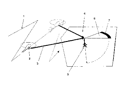
5 Figure 1 schematically shows a flight path 1 of an aircraft 2 comprising the
radar device according to the invention. The aircraft 2 may be a helicopter or
an aeroplane or any other suitable flying object that can carry a radar
equipment according to the invention. Figure 1 shows that a radar transmitter
transmits a vertically polarized beam 3 towards a selected ground area 4
10 while flying in a zigzag pattern.
Figure 1 show the principal of the system where an underground target 5
gives a target response on the surface 6 of the ground area 4 in the form of a
semicircle 7. At each instant of the SAR registration the response from the
target mixes with other reflections at the same electrical range. Figure 1
indicates that due to a large integration angle and a shallow depression angle
the target energy can be refocused to enable 3d imaging.
Figures 2a and 2b schematically show a comparison between a horizontally
polarized beam H-pol and a vertically polarized beam V-pol.
Figure 2a shows that the horizontally polarized beam H-pol is reflected
essentially in its entirety. The horizontally polarized beam H-pol must be
inclined with an elevation angle 8 being steeper than 400 or all transmitted
energy will go into surface reflection, see figure 3.
Figure 2b shows that for a vertically polarized beam V-pol at an elevation
angle 0 being the Brewster angle, the illumination geometry can be
configured so that the entire signal is launched into the ground by
refraction,
see figure 3. This process is supported by a ground wave component if the
surface is conductive.
CA 02613800 2007-12-05
11
Figure 3 schematically shows a diagram of a transmission coefficient as a
function of depression angle for horizontal polarization (fully drawn line)
and
vertical polarization (dotted line). The strong requirement for vertically
polarized radiation when the imaging angle, i.e. the elevation angle 0,
becomes shallow is evident in view of figure 3. Figure 3 shows that the
elevation angle 0 can deviate somewhat from the Brewster angle since the
differences between vertical and horizontal polarization, with regard to
refraction, are present in a fairly large angular interval around the Brewster
angle. The largest difference between vertical and horizontal polarization is
for an angle 0 in an interval between 0 and 400 and is most evident for an
angle 9 in an interval between 0 and 20 . Hence a suitable angle is in a
range of plus minus 5-100 about the Brewster angle. This shallow depression
angle is an indication that the radar device should be placed close to the
ground for short range operation.
Figure 4 schematically shows a covered surface (white area) by bistatic
arrangement depicted in figure 6. The hashed area is imaged by a single leg
B in the zigzag receiver movement. During the receiver motion along B the
transmitter moves along A. The resulting phase center movement is along C.
R is the average maximum range for transmitter and receiver. It will be set
by the maximum range for which surface wave propagation can be expected
for radar illumination.
Example: B: 20 m/s; A: 4 m/s ; C: 240 m; W: 107 m
Figure 5 schematically shows a geometric mapping of events. Rectangular
surveillance rate is determined by the "waist" created by the triangular
coverage regions from two adjacent receiver legs. Indeed the half the width
tt'12 is the distance from the path of the transmitting vehicle to the waist
point.
Figure 6 schematically shows the radar device according to the invention
used in a combination of a ground vehicle 8 and an aircraft 2. In figure 6 it
is
CA 02613800 2007-12-05
12
shown that the transmitter comprises a transmitting antenna 9 being mounted
onto the ground vehicle 8. The transmitting antenna 9 transmits a vertically
polarized first signal (beam 3 in figure 1) in the form of a lobe 10 towards a
selected ground area 4 in front of the ground vehicle 8. The transmitting
antenna 9 is preferably inclined towards the ground at a Brewster angle
being dependent on the index of refraction of the ground. The aircraft 2 flies
in a zigzag pattern 1 in order to enhance the synthetic aperture of the
previously described SAR. The aircraft 2 comprises the receiver comprising a
receiving antenna (not shown) for receiving information in a second lobe 11.
The received lobe 11 is transformed into a second signal being used for
further signal processing when producing a subsurface image.
The following text is to be read in connection to all figures 1-6.
The principle of diffraction limited synthetic aperture radar is a known
method
to obtain high 2-dimensional resolution of the ground surface. However, the
method has to be changed according to the invention for it to work for
subsurface imaging. In order to make it useful it requires a radar
configuration with the direction of radiation fairly close to the plane of the
ground so as to resolve the ground surface. The depth of a subsurface object
will be revealed by short depth of focus of diffraction limited SAR, just as
in
microscopy.
Basic to the refraction of radiation into the ground is Snell's law of
refraction
cosBo = ncosB (1.1)
(where the angle is with respect to the ground, which is assumed to be
horizontal). Snell's law is complemented by the Fresnel equations for the
reflection coefficient p. For vertical/horizontal polarization (of the
electric
field) one has respectively
CA 02613800 2007-12-05
13
2
nsinBo -sine
pV n sin Bo + sin B
nsinB-sin9p 2
PH nsin9+sinBp (1.2)
The sum of transmission and reflection coefficients are unity.
A typical index of refraction for ground may be n= 5, from which the
transmission coefficient is shown in Figure 3. The angle for which the
transmission coefficient is unity for a vertically polarized signal is called
the
Brewster angle. For the Brewster angle one has according to (1.1) and (1.2)
cos Bp sin Bp = cos 9 sin B
0 ~ 2 - Bp ~ tan 9p =1/n
(1.2)
It is evident from the diagram in figure 3 that for a near vertical depression
angle transmission and reflection coefficients are of the same magnitude.
Thus for radiation vertically impingent on the ground there will be about 50%
power loss. There will be an equally strong loss for the signal reflected by a
subsurface object when again passing the ground air interface, viz. there will
an overall loss of 75%. For a ground probing radar with antenna directly
above the ground these figures may be acceptable since the ground
response can be discriminated by pulse compression. For a standoff radar
looking down on the ground from height, the ground response cannot be
discriminated due to the curved nature of the wavefront, hitting the ground
surface at the fringes at the same time as the center is at the desired depth.
Such a radar configuration will therefore not be very useful.
As mentioned SAR relies on shallow depression angles and will thus be
highly ineffective for subsurface probing if horizontally polarized. As seen
from the diagram the situation will be different for a vertically polarized
signal.
Indeed if the Brewster angle is used as angle of depression, all power will be
CA 02613800 2007-12-05
14
refracted into the ground. Reciprocity - applicable at least to the degree
that
ground is lossless will guarantee that a signal will not be refracted by the
ground surface when backscattered from a subsurface target.
Radar wavelength A must be chosen by two conditions:
1. It must be short enough to put the underground objects to be
detected above the Rayleigh region with respect to the
wavelength inside ground (objects to be detected should have
a linear dimension of at least A/2 n)
2. It must be large enough not to reduce severely the field
impingent on top of the ground by shadowing effects caused
by ground roughness (ground roughness should have a linear
characteristic dimension of not more thanA/g ).
For instance, for flat open fields Az2"' may be a suitable choice of
wavelength. This assumes that grass, small boulders and the like to be
generally of less than 0.3 m extension
Propagating into the surface wavelength is shortened by the refraction index
n, i.e. around five times for n=5. Thus 2 m wavelength would be resonant to
an underground object of 0.2 m extension
Zenneck Surface Wave:
Wave propagation along a ground surface at the Brewster angle is peculiar
and deserve a detailed treatment in order that a more definite suggestion on
a radar design can be given. As it turns out the propagation effects are
closely related to electromagnetic surface waves in the sense of Zenneck. As
soon as the dielectric has some degree of conductivity wave propagation at
the Brewster angle will support a surface wave, with the precise property that
it does not give rise to any reflected wave. In the case of a truly lossless
CA 02613800 2007-12-05
ground medium, the surface component will be absent and a reflectionless
refraction process occur.
Consider a half space z:!~ 0 with conductivity K and permittivity E, and
assume z' 0 to be vacuum with zero conductivity and permittivity Co,
5 Assume the entire space to be non-magnetic with permeability 'Uo. The
question which will be illuminated here is whether there exist radiation
bounded to the x, 1' -plane, viz. with no free radiation component in either
the
z or the - z direction.
We shall assume propagation in the x, Z-plane, viz. with a magnetic field with
10 the one non-vanishing component Hy (x' Z) . There can be two electric
components EX (x, Z) and E_ (x, Z). The non-vanishing parts of time separated
Maxwell equations reads for z:5 0
azEX - ~Ez= -iwpoHy
- a H y=(x + i ws)Ex
az
a Hy = (x + iws)Ez
(2.1)
15 which implies
az a
~2 Hy +~2 Hy =itoPo(ac+im)Hy
(2.2)
This supports a solution for z:5 0
Hy =bexp( w2 -k2z-iwx) (2.3)
where
CA 02613800 2007-12-05
16
k2 = -iWf.co(K +iws) (2.4)
Because the solution should be a wave bounded to and propagating along
the plane z= 0, it must decay for z-> -011 so Re w2 - k 2> 0. For z> 0 we
get in a corresponding fashion
Hy = bo expl - wo2 - ko2 z- iwox I
ko2 = wZPoEo (2.5)
Notice that ko is real and in fact the wavenumber of the time separated
Maxwell equation. We are however not free to stipulate that this wavenumber
represents a plane wave. The wave must decay for z~ oO so
2 _ 2
Re wo ko > 0
Note that k is the wavenumber of the subsurface part of
the same wave. ko can assume any value and knowing the material
constants K, E, -co, and Po, we may compute k from this value. w and wo
will be determined from boundary conditions.
The electric fields are determined from (2.1). For z:5 0
__ 1 a _iP oa
EX K+ i r~e az Hy k r.~2 az Hy
E _ 1 aH --ito,uo aH
Z K+iQ)6 ax y k2 ax y(2.6)
and thus
w2 -k2
EX =imf.cp k2 bexp( w2 -k2z-iwx)
EZ =-wpo w k2 bexp w2 -kzz-iwx~
(2.7)
CA 02613800 2007-12-05
17
For z> 0
_ _ 1 a ir.~,uo a
EX iwe az Hy = k02 az Hy
a
1 a iw 0 H
EZ H _ _
y k 2 ~
iws ax y (2.8)
Thus
2 z
2k bo exp( l - w 2 -k 2z-iwoxl
I
EX =-iw 0 w ko \ J
EZ =-rv,u w2 bo exp(- w 2 -ko2z-iw x~
ko
(2.9)
Boundary conditions are that the tangential field components should be
continuous in the transition z--> 5. Thus
H y - component :
bo exp(- iwox) = b exp(- iwx)
EX - component :
Iwo 2 -k 2 w2 _k2
- iwpo k 2 bo exp(- iwox) = i~vu0 k 2 b exp(- iwx) (2.10)
It follows that b= bo; w= w and
CA 02613800 2007-12-05
18
w2 -ko2 wZ -k2
k0 2 k2
w2 -ko 2 _ w2 -k2
k0 4 k4
w2 = ko2k2 =:> w kok
=
k2 +ko2 k2 +ko2 (2.11)
It follows moreover that
w2 -k2 = ik2
k2 +ko2
wZ - k
0 2 iko2
k2 +ko2 (2.12)
since opposite signs of the root must be chosen according to (2.11).
Inserting (2.11), (2.12) in (2.3) and (2.5) we have
Hy = b exp - ik(kox - kz) <--= z< 0
Vk2+ko2
Hy =bexp-iko(kx-kaz) <-- z > 0
k 2 + ko2 (2.13)
When k and ko are real and positive (as indeed will be seen to be
approximately the case), (2.13) represents wave propagation directed along
a wave vector (ko,-k) for z:5 0 and a wave vector (k,-ko ) for z> 0. Both
directions are into the fourth quadrant in the x, z-plane.
The electric field amplitudes for z:5 0 become according to (2.7)
CA 02613800 2007-12-05
19
Ex -WPo b exp - ik(kox = kz)
k2 +k 2 k2 +k02
E _ -r~,u ko bex- ik(kox - kz)
Z k 2+ k02 k p k 2+ k 2 (2.14)
It is seen that (Ex , EZ ) 9 (k ,-k) oc (1, ko /k) =(ko,-k) = 0 viz. the
electric field (as
well as the magnetic field) are orthogonal to the direction of propagation.
For z> 0,(2.9) implies
Ex = -wP0 bexp-iko(kx-koz)
k2 +k 2 k2 +ko2
E -w~' k bexp -ik (kx-koz)
Z - k2 +k 2 ko k2 + k02
(2.15)
Again it is seen that (Ex , EZ )= (k,-ko ) a (1, k/k )= (k,-ko ) = 0
Let us substitute wavenumbers for the frequency and the material constants..
We have
r~n x 0)
k=- l-i-;k =-
c t08 c
k2 +ko2 = wn 1+ 1-i K
c n 2 ws (2.16)
where the speed of light c=1I-Vrp c and the index of refraction n- c
have been introduced. It wili be convenient to enhance interpretability
further
by introducing the vacuum wavelength of the radiation according to
CA 02613800 2007-12-05
o'/ c = 2,7 /A
. Moreover rather than conductivity the concept of critical
wavelength Ac (the wavelength for which attenuation is shorter than the
wavelength) is introduced according to
K _1;w -2~c=>
wcs ~
K 21Ic K A
-_-~-_-
s Ac wE Ac (2.17)
5 Thus
k-2;rn 1-i~ ;ko= ~
c k2+ko2 =2;m A. n 2 'Z'c (2.18)
The magnetic field amplitudes may thus be re-expressed
X -n 1-i A ?
Hy = b exp- i27r A A' i G z< 0
1+ 1 -i11
n2 AC
~ x 1 z
1-i-----
H y= b exp- i 2Tr A nA - z> 0
1 + 1 - i ~
n2 ~~ (2.17)
From which the electric field amplitudes readily follows.
10 Let us consider the case that K= 0, viz. 'lc
~~0
CA 02613800 2007-12-05
21
x z
--n-
Hy =bexp-i27r A A <-- zSO
F+n
x 1 z
Hy = bexp-i2;r n G z> 0
F+n (2
.18)
Evidently, in this case
2;r I 2;r n
kz ;kZ=- z<0
~ 1+n2 A 1+n2
21r I 2;r 1
kX=- ;kz=- z>0
A 1+n2 A n l+n2 (219)
One finds that above or under ground the solution constitutes plane waves
with wavenumbers
kx2+k22 = 27r GzSO
I k x2+k2-27rI Gz>0
A n (2.20)
Propagation occurs at an angle of elevation 8= tan-1 kZ /kX i.e. at an angle
B= tan-I 1/n for z> 0 and at an angle 9= tan-' n for z< 0. Snell's law of
diffraction is satisfied, as is evident from the agreement of the kx
wavenumber components above and under ground.
CA 02613800 2007-12-05
22
Material constants for some types of ground are
n AC
Dry soil 3,2 11 m
Wet soil 5,5 33 m
Sand 3,2 83 m
Sea water 8,8 0,26 m
Since n 1 in all cases, one may write approximately
Hy =bexp-i21r X-n 1-i~A z Gz<0
c
Hy = bexp-i27r x- I I z z> 0
A n A
11 1-i-
AC (2.21)
One finds is that up to this approximation the Zenneck wave is not attenuated
in thex-direction. This result is not dependent on the conductivity but on the
magnitude of the refraction index.
For wavelengths not more than a few meters AlAc will be small in which case
one may by Taylor expansion write
Hy =bexp7rn~ exp-i27c~~-n~~Gz<0
c Hy = bexp- n~ exp-i27r(-A nA) G z > 0
c (2.22)
Again the Zenneck wave is seen to be plane wave character obeying Snell's
law of refraction, albeit it will be attenuated in the z -direction. Since n
I
CA 02613800 2007-12-05
23
the propagation occurs at shallow depression angles above ground. The so-
called Brewster angle is the angle of a perfect dielectric at which no
reflection
occurs against a horizontal surface for vertically polarized radiation. It is
given by
BBrewster = tan-1 kZ = tan-1 I
kx Z>0 n (2.23)
It is thus seen that as '~~'~~ ~ 0, the Zenneck wave becomes a plane wave
totally refracted into the ground or (by the reciprocity theorem) a plane wave
emerging oUt of the ground without reflection at the boundary.
Assuming AIA, # 0 and n< oO, the Zenneck wave will be seen to be
attenuated in the X-direction as well. One finds the lowest order imaginary
component in the denominator of the exponents of (2.17)
1+ 1-i ~ 1+ 1
n 2 2n2 1-i -
/TC
1-i I 1+ 1 +i "
~.C 2n2 2n2~~ (2.24)
Hence instead of (2.21)
~ ~ z< 0
Hy bexpir n~ - 2Aexp-i2;r(A x nA
~ n ~
Hy = bexp;r - n~ - 2~ exp-i27r~~ n ~1 G z > 0
c n C J
(2.25)
We thereby obtain four interesting parameters of the Zenneck ground wave
ta"' llviz. the wave tilt n , the characteristic penetration depth '~~ ~n ,
the
CA 02613800 2007-12-05
24
characteristic vacuum extension nAc and the characteristic propagation
range n2Ac. For the materials above - but for sea water - the approximation
A Ac will be applicable and we obtain
tan-I 1/n Ac/n nAc n2Ac
Dry soil 100 3,4 m 35 m 112 m
Wet soil 17 6,0 m 181 m 998 m
Sand 100 26 m 266 m 850 m
The analysis makes the physical interpretation of the Zenneck wave plain. It
can be summarized as follows. At the Brewster angle a wave incident on the
ground along a certain line of propagation will have no reflection component,
if there is a perfect impedance matching, so the wave will become totally
refracted into the ground, with the propagation line bending according to
Snell's law of refraction. However, according to the boundary conditions, the
electric field component diminishes in the refraction process, see equations
(2.14) and (2.15). The electromagnetic power flux (the Poynting vector) will
thus diminish abruptly along the electromagnetic line of propagation when it
hits the ground surface. The energy balance can not be saved unless the
remaining power is a source for a spreading of the incident wave to larger X-
values over the ground surface. The power of the incident wave will thus
decline exponentially with growing x-values.
Subsurface Imaging Radar Design:
Based on the preceding theoretical results general radar design aspects for
subsurface imaging radar may be given.
CA 02613800 2007-12-05
The candidate subsurface target is conceived to be of metal and with an
extension of at least A/n ;::z0.2 m. It will provide a total although maybe
diffuse scattering of the incident radar signal. The natural subsurface
clutter
elements such as stones and tree roots, will have refractive properties
similar
5 to the soil itself. Natural ground in homogeneities will also - mostly -
occur at
smaller length scales than those of true targets. For these reasons
subsurface clutter should provide weaker backscattering than true targets.
For this effect to be useful for false alarm rejection, radar resolution must
be
so high that the isolated scattering elements, be they targets or clutter,
would
10 normally be isolated within the resolution elements, thus avoiding speckle
effects. Hence radar resolution close to radar wavelength must be achieved.
Assuming stationarity of subsurface targets, the SAR principle is suitable to
attain this high resolution. By the same reasoning as for ordinary SAR, the
entire subsurface volume may be conceived as a reflecting continuous
15 medium, for which each point P scatters independently and in all directions
with intensity f(P) assessed by the SAR imaging procedure
T
.f (P)= JF(rQ1p,tt
-T (3.1)
Here F(r,t) is the pulse compressed radar signal whereas rGP is the "radar"
range (range in vacuum corresponding to the delay of the radar return) from
20 the current platform position Qt to the point P in the radar scene.
For subsurface scatterers, only backscattering directions within an angle
sin-' (1/n) around the ground normal will be refracted through the ground/air
interface and give rise to radar returns. Also, the scattered signal from
below
the ground is reduced by reflection, passing through the ground surface.
CA 02613800 2007-12-05
26
As seen in Figure 3, the subsurface reflection losses are very much affected
by polarization. This is of particular significance in the present large
surveillance rate application, where depression angle must be small. At the
depression angels typical for SAR the use of vertical polarization seems a
requirement to achieve illumination both on the actual ground surface (rather
than at some fraction of the wavelength above the surface) and to obtain
refraction into the ground. Brewster angle incidence is maximizing the
surface/subsurface target response with respect to that from objects elevated
from the ground. For horizontal polarization 2-way reflection losses are seen
to amount to 20 dB attenuation of the backscattered surface/subsurface
signal at Brewster angle incidence.
As mentioned, clutter false alarms must be removed in the radar detection
process. This can be done by any or a combination of three well-known
strategies for SAR target detection:
1) Thresholding the image intensity to exihibit only alarms of a certain
strength
2) Group detection, e.g. scanning the image for regular or indicative patterns
of alarms. A mine field can be a typical case for group detection.
3) Change detection, comparing images over the same area registred a time
apart. Surveying roads are typical applications"
A challenge in subsurface SAR imaging is that the region to be imaged is 3-
dimensional whereas range gating and SAR focusing only provides 2-
dimensional clutter rejection. As now will be analyzed - SAR imaging at
diffraction or wavelength resolution has the property of short depth of field,
which can resolve 3-dimensional ambiguities.
The defocusing of SAR images may be modeled sufficiently well by
assuming an infinite index of refraction. Thus shallow depression angle SAR,
propagates radar signals in (essentially) the horizontal plane to a point on
top
CA 02613800 2007-12-05
27
of the underground target at which point propagation becomes vertical down
to the target. Let the underground target be positioned at P=(x, y,-z) aiong
the x- axis and let the SAR path be along the y- axis, viz. Qt =(0, vt,0) The
"radar" range from any point Y on the SAR path to the subsurface target will
be
r= x2+(y-vt)2+nz (3.2)
For short SAR apertures close to y= 0, one may substitute (3.2) for its first
order approximation
r = x + (y - vt)2 + nz
2x (3.3)
Thus the SAR imaging principle will attribute equal image amplitude to any
pair of image points P - (x y,-z) and P=(x - nSz, y,-z +&z) Hence there will
be no means of discrimination between subsurface and surface responses. A
sensitivity to the parameter z will however appear for larger SAR apertures.
Indeed carrying out the integral (3.1) for a point P=(x - n&z, y,-z +&z)
displaced from the actual target positionP' =(X, y,-z), the integral will
start to
decorrelate if the radar range difference rQP -rQ~p' becomes larger than a
quarter of a wavelength. For half a wavelength difference decorrelation will
be complete, viz. the target response will not spread to an image point
displaced by the corresponding amount. Based on these observations, we
obtain
Sr = x& + n8z = n8z x2 +(y - vt)2 - x
x2 +(.y-vt)2 ~X2 +(y-vt)2
2 2
n y - vt~_~.x
~2 x 2 n(vT)
(3.4)
CA 02613800 2007-12-05
28
Since wavelength resolution imaging requires z74 vT one finds a depth of
field & = Aln. With the cited values A ~~ 2 m and n~ 5 one finds '5Z = 0.4 m.
The corresponding results for a finite index of refraction would give more
complex formulas but no significant differences as regards depth of field.
3-dimensional discrimination capability could alternatively be obtained by a
richer radar raw data set than that of a conventional SAR. For instance, the
directivity achieved by a vertically extended SAR antenna can in principle
provide 3-dimensional resolution and thus discrimination between surface
and subsurface responses. The non-resolvable 3-dimensional surrounding of
any subsurface target will contain the vegetation layer above ground and any
other subsurface responses down to the penetration depth of the signal. The
vegetation layer and the penetration depth are seldom more than a few
meters, however. In view of the required meter-size wavelength and the
standoff distances required for large surveillance, one must therefore
conclude that this requirement on vertical antenna resolution is much too
severe to be achievable only by real antenna resolution operating at.
To summarize, the most important aspects on successful subsurface irriaging
radar seem to be 1) vertical polarization and 2) wavelength resolution to
obtain a short depth of field and 3) proper wavelength choice. The use of an
exact Brewster angle is not so important since the differences between
vertical and horizontal polarization are present in a fairly large angular
interval around the Brewster angle.
It was concluded above that for finite soil conductivity, launching a
vertically
polarized signal with an electric field inclined at the Brewster angle led to
a
refraction process creating a surface wave signal tapped by continuous
refraction into the ground, but without any reflection component. This
conclusion is significant for the practical difficulty of housing a low
frequency
vertically polarized antenna onboard an airborne SAR platform. For the short
ranges considered, transmit power will be fairly small, so for an airborne
CA 02613800 2007-12-05
29
radar it is not required that the transmit antenna has a vertical extension of
more than half the wavelength, i.e. in our case of around 1 meter. However
even this length would be a concern for a small airborne system, mounted on
e.g. an UAV. The fact that the radar signal can be a surface wave can be
used to realize subsurface imaging radar by a bistatic arrangement. In such
an arrangement the transmitting antenna can be close to the ground and
launch a surface wave.
The transmit antenna would typically be mounted on a ground vehicle moving
at moderate speed in the x-direction. Being mounted on a vehicle the
transmit antenna can be inclined at the Brewster angle and vertically
extended a few meters to make the radiated beam vertically narrow and
conversion of the radiated energy into a surface wave efficient. The receiving
antenna can have a vertical extension less than half a wavelength and thus
easily be installed on a UAV or helicopter. The receiving platform would
travel in a zigzag fashion above the transmitting ground vehicle, spanning the
synthetic aperture by the amplitude of the zigzag motion.
The SAR surface resolution formula is
A.4=0BxA' x c
2 2B (3.5)
Where Ae is integration angle and B is bandwidth. Given a center
wavelength ~c ~-- 2 m, a bandwidth of 100 MHz providing 1.5 m range
resolution c12B seems attainable. This resolution should be matched by a
similar azimuth resolution A8Ac /2. Thus AB ~ 600.
The SAR aperture length refers to the motion of the phase center, which for a
bistatic arrangement is half the amplitude of the actual distance traveled by
the receiving platform. Given that characteristic surface propagation ranges
may vary from 100 to 1000 meters, one would expect a radar range of 200 m
CA 02613800 2007-12-05
to be practical in most application, i.e. even if the characteristic range for
surface wave propagation is 100m.
The area covered by the zigzag receiver motion is depicted in Figure 2.
Denote the length of the phase center motion for a single leg by B, whereas
5 A is the amplitude of the leg. Thus
B= A a= tan -1 vX ~ vx
2cos2a vy ~ vy
(3.6)
where vx is the velocity component of the receiver in the X-direction as well
as the ground velocity of the transmitter. One may assume v" << vy . For the
triangular (hashed) area imaged by a single leg one obtain the following
10 requirement for the zigzag amplitude
3
sin( 3+ 2a~ sin
C~
R B
2R
1 + 2Ta (3.7)
The rectangular strip that can be inscribed into the covered (irregular) area
is
really the useful part of the imaged area. Its width W is therefore of
interest.
We get from Figure 3
sin~ 2)r - 2a
3 sin2a
B X
- 9 ~
sin sin -
(3 2a
3
R-X B W
-+
15 2 2 cos 2a (3.8)
Again considering a first order approximation in a
CA 02613800 2007-12-05
31
NF3 - 2a 2a
2B X
~+2a ~3-
2(R-X) B+W (3.9)
Thus
W=2R-B-~Ba~
W=R 1-~a
(3.10)
For instance, if "x = 20 m/s (cruise speed of helicopter UAV) and ''y 2 m/s
one has a= 0.1. Then A= 297 m and W =154 m according to (3.7) and
(3.10) respectively. Area coverage rate is 2 m/s x 154 m = 307 sqm/s.
Given the depth of field - 0.4 m - the height of the underground pixel
volumes should be no larger than 0.2 m. For 5 m penetration depth the
ground should thus be sliced into 25 subsurface layers, each processed with
parameters adjusted for a corresponding electric depth nz. With 1.5 m
surface resolution the horizontal pixel dimensions may be 0.5 m x 0.5m. A
one leg aperture is flown in 297 m / 20 m/s = 15 s. During this time the total
number of pixels processed wilt be 25 x 297/2 x 154 / 4 = 1.3X10⁶. The pixel
output rate is about 150 kpixel/s. Given 64 bit complex amplitude format the
data output rate is thus 9.8 Mbit/s - a tolerably low number.
There are a number of important practical concerns for this type of radar.
Foremost there is the choice of waveform, which is a critical subject due to
the large bandwidth required and the short operating range. One possible
mode of operation is by waveform generation by an impulse device (e.g. an
avalanche diode), with transmit duration equal to the reciprocal of the
bandwidth. These devices typically produce mean power in the regime
required for ground probing radar GPR. For SAR the extended integration
CA 02613800 2007-12-05
32
time balances the spreading of radiated energy over a much larger area, so
power requirement would be similar to those of GPR. Thus impulse
waveforms may be possible waveform candidates. Still impulse waveforms
require digitization at least at 200 MHz, which rate is essentially too high
for
data transfer for subsequent signal processing.
As a remedy, stepped frequency waveforms are useful. They require step
bandwidth so large as to allow sufficiently short pulses for the short
operating
range. However 15 m long pulses may be quite acceptable from an operating
point of view, allowing 10 MHz step bandwidth, viz. 10 frequency steps
across the radar bandwidth. Impulse devices may be used also for stepped
frequency operation but will for 10 steps spill 90% of the power outside the
received band. For power efficient operation fast transmit/receive switching
of a linear transmitter must be attained, viz. switching a 200 MHz carrier
with
switching times of the order 50 ns.
The second practical concern is that of reducing motion uncertainties in the
SAR configuration. Both the motion of the transmitting ground platform
relative to the ground and the relative motion between airborne receiving and
transmitting ground platform must be known. For SAR image formation the
accuracy of knowledge of the motion must be within some fraction of the
wavelength - say an RMS value of 0.3 m.
The fact that the ground platform has contact with the ground makes a
precise determination of its movement on the ground possible by several
methods, e.g. laser movement detection techniques. The relative motion
between the ground and airborne platforms is simpler to asses than an
absolute motion. This is particularly so, since the distance between the
platforms is not very great. One option is carrier differential GPS, by which
the required high relative accuracy possibly may be attainable. Other options
also exist, e.g. beam riding devices where the airborne platform may sense
the deviation from a linear flight path laid out by a laser ray from the
ground
platform.