Note : Les descriptions sont présentées dans la langue officielle dans laquelle elles ont été soumises.
CA 02636235 2008-07-03
WO 2007/077169
PCT/EP2006/070174
1
ACTIVE DEVICE FOR THE RECEPTION AND THE EMISSION OF
ELECTROMAGNETIC WAVES
The present invention relates to an active device
for the reception and the emission of electromagnetic
waves, especially for carrying out measurements by means
of localisation systems, such as the synthetic aperture
radar system.
BACKGROUND OF THE INVENTION
Localisation systems are known such as radar that
permit objects to be detected, measured and localised by
sending electromagnetic waves.
The radar system sends bursts of electromagnetic
waves by means of an antenna and is capable of picking up,
either by the same antenna or by an additional antenna,
the echo or reflection of the waves caused by the presence
of the objects.
As is now known, with a synthetic aperture radar
it is possible to generate images of terrestrial surfaces
in which, basically, the position of one point is a
function of the distance between the platform on which the
radar is mounted (for example, a satellite) and said point
situated on the ground.
The information provided by a radar is useful for
measuring movements of the soil or of buildings by means
of techniques called radar interferometry correlation. In
order to be able to study with precision the movement of a
particular point of an image, it is essential that said
measurement point be a reflective point that remains
permanent over time, that is, one that does not change
with time. Thus if, for example, said point is the surface
of the roof of a house, that house cannot be altered
(demolished, or changed by adding a further storey).
CA 02636235 2008-07-03
WO 2007/077169
PCT/EP2006/070174
2
Often, however, it is necessary to study earth
movements in zones that do not remain stable over time,
such as wooded zones, snow-covered zones or sea zones
(petroleum extraction zones), in which it is difficult to
find features or structures useful to serve as stable
reflecting points. In order to be able to have measuring
points in such zones it is necessary to have artificial
reflecting points such as the so-called passive reflectors
(trihedral, dihedral or specular "corner reflectors") and
the so-called active reflectors ("active transponder").
Corner reflectors are passive electromagnetic wave
receiving and re-emitting devices that comprise metallic
trihedrals that act as mirrors to the waves coming from
the radar. Such corner reflectors present the disadvantage
that they must be situated in zones where they cannot be
covered by vegetation or snow, since they need a sight-
line on the radar both for receiving the signal and for
reflecting it.
The classic active devices for receiving and re-
emitting electromagnetic waves have a receiving antenna
that receives the signal coming from the radar and,
usually, also an additional emitting antenna that resends
said signal. Said systems also present the disadvantage
that they need to have a sight-line on the radar in order
to receive the signal and allow it to be re-emitted (it
should be taken into account that the signal that comes
from a radar situated on a satellite cannot be amplified
to improve its reception, since said satellite is at an
altitude of 800 km).
In any of the devices cited, reception and re-
emission of the electromagnetic signal from a radar is
impossible in zones close to the poles or subject to high
snowfall, since in those zones the receiving and emitting
points are always covered in snow. And with the devices
cited, in order to ensure reception and re-emission of the
CA 02636235 2014-02-19
'
3
signal in wooded zones it is essential to fell trees. Thus, it
is not economically or environmentally viable in such zones to
calculate earth movements by processing radar images
(interferometry).
DESCRIPTION OF THE INVENTION
The objective of the present invention is to resolve the
disadvantages mentioned by developing an active device for the
reception and the emission of electromagnetic waves,
especially for carrying out measurements by means of
localisation systems, that enables the creation of artificial
measuring points that are retained over time, in an easy,
simple, low-cost and environmentally viable way.
In accordance with this objective, the device of the
present invention comprises a receiving antenna that receives
the electromagnetic signal coming from said localisation
system and at least one emitting antenna that resends said
signal to said localisation system, and is characterised in
that said device includes a plurality of said emitting
antennae connected to at least one receiving antenna, in such
a way that said emitting antennae receive the electromagnetic
signal coming from said at least one receiving antenna, being
each one of said emitting antennae the ones which resend the
signal to said localisation system.
In accordance with an aspect of the invention, there is
provided an active device for the reception and the emission
of an electromagnetic signal (2) for measuring movements of
particular points of a terrestrial surface by means of a
localisation system (3), said active device comprising:
CA 02636235 2014-02-19
3a
at least one receiving antenna (6) which receives
the electromagnetic signal (2) coming from said
localisation system (3); and
a plurality of emitting antennae (8), connected to
said at least one receiving antenna, that resend
said electromagnetic signal (2) to said localisation
system (3),
wherein said plurality of emitting antennae (8) are
connected to said at least one receiving antenna (6)
in such a way that each of said plurality of
emitting antennae (8) receives the electromagnetic
signal (2) coming from each of said at least one
receiving antenna (6),
wherein each of said plurality of emitting
antennae (8) resends the electromagnetic signal (2)
to said localisation system (3), and
wherein a location of each of said plurality of
emitting antennae corresponds to a particular point
of the terrestrial surface.
In the present invention, localisation system will be
preferably taken to mean a system capable of sending out and
of picking up electromagnetic waves that permits points to be
detected, distances measured and/or objects located, such as a
synthetic aperture radar, an altimetric radar or a fixed
radar.
Preferably, said electromagnetic waves will be high-
frequency waves (microwaves).
CA 02636235 2008-07-03
WO 2007/077169
PCT/EP2006/070174
4
Surprisingly, the device of the present invention
presents the advantages that are described below in
relation with the devices of the state of the art.
On the one hand, it offers the possibility of
creating artificial measuring points that are retained
over time easily, at low cost and simply, whether it be in
wooded zones, snow-covered zones or at sea.
This is due to the fact that, in the device of the
invention, the emitting antennae are physically separated
from the receiving antenna, that is, the signal from the
radar is received on the land surface only by the
receiving antenna, while that same signal is sent back by
the plurality of emitting antennae connected to the
receiving antenna. Thanks to these characteristics, the
emitting antennae do not receive the signal but only send
it, for which reason they do not need to be placed in
zones visible to the radar. Moreover, if said emitting
antennae have sufficient power, they can even be placed
beneath the snow or under trees.
Unlike the devices of the state of the art, in the
device of the present invention the points on which the
emitting antennae are situated are the only ones that act
as reflecting points or measuring points of the
localisation system. The site at which the receiving
antenna is located does not therefore constitute a
measurement point of the system. Thanks to this, the
receiving antenna can be situated in a zone that ensures
high visibility of the radar (the positioning of this
antenna does not affect the quality of the measurements)
and said antenna can at the same time be protected from
inclement weather, for example by means of a small roof.
Another important advantage of the device of the
present invention lies in the fact that it offers greater
measurement precision.
Indeed, the device can have a single receiving
CA 02636235 2008-07-03
WO 2007/077169
PCT/EP2006/070174
antenna for receiving the signal from radar. It is
therefore a centralised reception device that carries out
multiple emission of the signal by means of the plurality
of emitting antennae connected to the receiving antenna.
5 Said centralised reception offers the advantage that it
permits sources of error related with reception to be
eliminated.
As is known, in localisation systems that use
radar, the position of a point is in function of the
distance between the radar and said point. Taking into
account that the speed of propagation of an
electromagnetic wave in space is equal to the speed of
light, measurement of the distance between the radar and
said point is based on calculating the outward and return
time of the electromagnetic wave from the radar to the
aforesaid reflector point. Atmospheric disturbances such
as changes of temperature can mean that the time elapsed
between reception and re-emission of the signal is not
uniform for all the measuring points.
However, in the device of the present invention,
unlike the devices of state of the art, as there is only
one receiving antenna connected to the emitting antennae,
the variability in the measurements due to the different
reception times of the signal caused, for example, by
atmospheric disturbances, is eliminated, thereby providing
greater measurement precision.
According to a preferred embodiment of the device
of the present invention, the localisation system
comprises a radar mounted on a platform, preferably a
satellite, said radar being of the type capable of
generating images and recording on said images the signals
emitted by each one of the emitting antennae of the
device. According to the same preferred embodiment, the
emitting antennae are mounted on the surface of a
structure or element that moves, with each one of said
CA 02636235 2008-07-03
WO 2007/077169
PCT/EP2006/070174
6
antennae constituting a data measurement point.
The preferred embodiment described enables use of
the device of the present invention to measure
deformations of land or buildings by means of techniques
called radar interferometry correlation (processing of
radar images).
With the device of the invention, the calculation
of earth movements by interferometry radar techniques is
possible and economically and environmentally viable in
any type of zone, since, as we have remarked, it permits
the creation of artificial measuring points that are
retained over time, whether in wooded zones or snow-
covered zones.
Preferably, the device of the present invention
includes means of amplification of the power of the signal
coming from said at least one receiving antenna. Thanks to
this it is possible to ensure that the signal resent by
the emitting antennae returns to the radar. In particular,
said means of amplification are very useful when the
emitting antennae are covered by abundant snow or dense
vegetation.
Advantageously, the connection between said at
least one receiving antenna and said emitting antennae is
wireless.
Also preferably, the device of the invention
includes means of control of the time elapsed between
reception of the signal by said at least one receiving
antenna and emission of the signal by each one of the
emitting antennae of said device. Thanks to this, it is
possible to delay and/or advance the emission of the
signal, in such a way that the echoes from the emitters
installed at a fixed geographical position can be recorded
virtually on points of a radar image that do not
correspond with the geographical location of the emitters
zone.
CA 02636235 2008-07-03
WO 2007/077169
PCT/EP2006/070174
7
Advantageously, the device of the invention
includes a plurality of receiving antennae connected to
the plurality of emitting antennae.
The existence of various receiving antennae
connected to a single group of emitting antennae means
that, by delaying and advancing the emission of the
signal, the echoes or waves transmitted by said emitting
antennae can be recorded virtually in images coming from
adjacent trajectories of the radar. The frequency of
delivery of information is thus greater than that obtained
with the devices of the state of the art for a given set
of measuring points (emitting antennae), since a single
pass of the satellite through the zone of the emitters
provides a larger number of measurements.
Also advantageously, the control means of the
device include means to defer the sending of the signal
coming from the at least one receiving antenna to the
emitting antennae connected to said receiving antenna.
In this way, the device of the invention can
guarantee the confidentiality of certain measuring points,
because by delaying the sending of the signal to the
emitting antennae, the echoes or waves transmitted from
said emitting antennae can be recorded virtually on an
image whose points do not correspond with the exact
geographical localisation of the emitting antennae or
measuring points.
Also advantageously, the control means of the
device include means to individually defer emission of the
signal from at least one of said emitting antennae
connected to said receiving antenna.
It is thus possible to achieve an increase in the
apparent resolution of the radar. For example, in zones
where the measuring points (emitting antennae) are
situated every 2 metres (a distance shorter than the
typical 10-metre resolution offered by a radar of the
CA 02636235 2008-07-03
WO 2007/077169
PCT/EP2006/070174
8
ENVISAT type), the reading of the echoes or waves
reflected by the emitting antennae is recorded jointly,
which prevents their individual analysis. In such zones it
is very useful to defer emission of the signal from the
emitters in order to be able to simulate a grid of
measuring points separated by at least 10 metres, which is
the resolution offered by the radar.
Optionally, the device of the present invention
includes means for coding the signal coming from said at
least one receiving antenna, said means acting before
emission of the signal by means of said emitting antennae.
The aforesaid coding allows the sending of coded
artificial echoes over the emitters that can only be read
if decoded by a specific program.
Alternatively, the device of the present
invention can include means for coding information from a
source external to said localisation system, means for
transmitting said coded information to said plurality of
emitting antennae, and means for controlling the mode of
emission of the signal from the emitting antennae in
function of said coded information.
Thanks to this, during emission of the signal,
information can also be sent about the meteorological
conditions, or, for example, information coming from
geographical information systems, which can be left
recorded in coded form on the radar image.
BRIEF DESCRIPTION OF THE DRAWINGS
For a better understanding of the matters outlined
herein some drawings are attached which, schematically and
solely by way of non-restrictive example, show practical
cases of embodiment.
In said drawings,
Figures la and lb show an installation of devices
CA 02636235 2008-07-03
WO 2007/077169
PCT/EP2006/070174
9
of the state of the art in a wooded zone.
Figure 2 shows a plan view of a preferred
embodiment of the device of the present invention.
Figure 3 shows a side view of the device of the
Figure 1.
Figure 4 shows a schematic view of an embodiment
of the device that includes three reception antennae
connected to a sole set of emitting antennae.
Figures 5, 6 and 7 show three radar images of
adjacent trajectories on which the measuring points
corresponding to the emitting antennae of the device are
shown recorded.
DESCRIPTION OF PREFERRED EMBODIMENTS
Figure la shows an installation of devices 1 of
the state of the art that has been implemented in a wooded
zone. Each one of said devices 1 includes a receiving
antenna and an emitting antenna of electromagnetic waves
2.
The devices 1 shown present the disadvantage that
the receiving antenna must have a sight-line on the
satellite that includes the radar 3 in order to be able to
pick up and resend the waves 2. Thus, as Figure lb shows,
in order to ensure reception and emission of the signal 2
in a wooded zone it is essential to fell the trees that
obstruct the line of sight between the radar 3 and the
receiving antennae.
In addition to being expensive, the felling of
trees is also environmentally inappropriate, so that in
practice the installation of devices 1 in wooded zones is
not very viable. The same is true when the installation
must be carried out in zones that are normally snow-
covered, since this likewise blocks the sight-line on the
radar 3.
CA 02636235 2008-07-03
WO 2007/077169
PCT/EP2006/070174
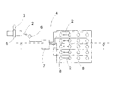
Figure 2 shows a plan view of a preferred
embodiment of the device 4 of the present invention
installed in a heavy-petroleum extraction zone. In the
embodiment described, the device 4 comprises a synthetic
5 aperture radar 3 capable of generating images (SAR
system). Said radar 3 is mounted on a single satellite 5
or a cluster of satellites 5.
The technical characteristics of the SAR radars
that can be used in the present invention are as follows:
10 = Wavelength K,X,C,L, in the embodiment, C.
= Distance Off nadir: 1-1,000 km, in the
embodiment 180-670 km.
= Angle of incidence 5-80, in the embodiment 15-
45.
= Resolution from 0.1 to 20 metres, in the
embodiment 10 metres.
= Polarisation HH, VV, HV, VH and all combinations
of the foregoing, in the embodiment, HH or VV.
= Cycle: from 1 to 50 days, in the embodiment 35
days.
The device 4 includes a receiving antenna 6, a
control centre 7 connected to an electrical power source
and a plurality of emitting antennae 8 set on the ground
between the trees 9 and connected to said receiving
antenna 6 through said control centre 7. Each of said
antennae 8 corresponds to a data measurement point.
The technical characteristics of the receiving and
emitting antennae that can be used in the present
invention are as follows:
Receiving antenna:
= Band K,X,C,L, in the embodiment C.
= Multi-incidence, in the embodiment 15-45.
= Multi-polarisation, in the embodiment H or V.
Emitting antenna:
= Wavelength K,X,C,L, preferably X,C, in the
CA 02636235 2008-07-03
WO 2007/077169
PCT/EP2006/070174
11
embodiment C.
= Omnidirectional
= Power up to 1 kW or more, in the embodiment 10
watts.
= Polarisation H,V, in the embodiment H or V.
= Size: between 20 cm and 2 m, in the embodiment
50 cm.
In the embodiment described, the device is used to
measure the deformations to which the land is subject in
petroleum extraction. A technique called radar
interferometry correlation is used for this purpose, in
which each one of said emitting antennae 8 corresponds to
a point from which its relative deformation will be
measured. In short, the idea is to monitor a petroleum
extraction zone situated in a wooded zone of boreal type
covering an area of 1 km2 and for which it has been
calculated that 20 measuring points are necessary.
There follows a description of the mode of
operation of the device 4.
The device 4 receives the signal 2 through the
receiving antenna 6, and the control centre 7 then gives
the order to the emitters 8 for them to emit the signal 2
towards the satellite 5. Emission of the signal 2 is
carried out consecutively following the direction of
advance of the satellite 5. The passing of the satellite 5
over the device 4 supplies an image on which are recorded
the echoes or waves 2 reflected by the emitting antennae
8. A study of the phases of said reflected echoes or waves
2 will permit measurement of the relative movement on the
ground of the emitting antennae 8 (measuring points).
In the embodiment described, the control centre 7
of the device 4 includes power amplification and coding
means of the signal 2 coming from the receiving antenna 6.
This power amplification ensures correct re-emission of
the signal 2 in zones where the vegetation is very thick,
CA 02636235 2008-07-03
WO 2007/077169
PCT/EP2006/070174
12
while the coding enables the sending of coded radar echoes
or waves 2 that are only visible on radar image if they
are decoded.
Coding of the signal 2 prior to its re-emission is
useful for ensuring the confidentiality of the
measurements taken. However, the device 4 also permits the
confidentiality of the measurements taken to be ensured
simply by deferring the sending of the signal 2 coming
from the receiving antenna 6. Indeed, the control centre 7
may optionally send an order to the set of emitters 8 so
that the signal 2 is sent out with a certain delay. In
this way, the reflected radar echoes or waves 2 are
recorded virtually on a radar image whose points do not
correspond with the exact geographical localisation of the
enclave in which the emitters 8 are situated.
Figure 4 shows a schematic view of an embodiment
of the device 4 that includes three receiving antennae 6
connected to a sole plurality of emitting antennae 8.
As noted in the description of the invention, the
addition of supplementary receiving antennae 6 has the
advantage of permitting the frequency of delivery of
information to be increased, since the radar echoes or
waves 2 reflected by the same group of emitters 8 can be
recorded on various images with trajectories adjacent to
the radar 3. This means that in practice the number of
measurements made by the same emitters 8 situated in a
specific geographical zone can be increased, without
having to wait for the satellite 5 to make the complete
trajectory of its orbit to pass again over the zone of the
emitters 8. For example, in the case of a radar satellite
with a nominal orbit of 35 days (ENVISAT), the use of
supplementary receiving antennae can achieve an image
every 3 days instead of every 35 days.
There follows an outline of the operation of
Figure 4.
CA 02636235 2008-07-03
WO 2007/077169
PCT/EP2006/070174
13
In the embodiment of Figure 4, the signal 2 from
the radar 3 arrives from the left, so that the first
receiving antenna that picks up the signal 2 is the
reference antenna 6a. At the time when the antenna 6a
picks up the signal 2, the satellite 5 has not yet crossed
the geographical zone in which the emitters 8 are
situated. So, if the aim is for the radar echoes from said
emitters 8 to be recorded (virtually, of course) on the
radar image 10a, which corresponds to the geographical
location of the antenna 6a, it is essential that the
control centre 7 orders the emitters 8 to emit a certain
time in advance.
The second receiving antenna that picks up the
signal 2 is the antenna referenced 6b. In this case, the
radar echoes from the emitters 8 will be recorded on the
radar image 10b, which is the image of the geographical
zone in which said emitters 8 really are located.
The last antenna that will pick up the signal 2 is
the antenna referenced 6c. By the time the antenna 6c
picks up the signal 2, the satellite 5 has already crossed
the geographical zone where the emitters 8 are situated.
So, if the wish is for the radar echoes from said emitters
8 to be recorded (virtually) on the radar image 10c, which
corresponds to the geographical location of the antenna
6c, it is essential that the control centre 7 orders the
emission of the signal 2 with a certain delay.
Figures 5, 6 and 7 show the three radar images
10a, 10b and 10c, corresponding to the three adjacent
trajectories of the satellite 5. As noted above, each of
said images 10a, 10b and 10c show the recorded radar
echoes or waves 2 reflected by the emitters 8 of the
device 4. In such a way, a higher frequency of
measurements is obtained with a single pass of the
satellite 5 over the emitters 8 zone.
The control centre 7 of the device 4 can also be
CA 02636235 2008-07-03
WO 2007/077169
PCT/EP2006/070174
14
used to increase the apparent resolution of the satellite
5. Thus, in zones where it is of interest to have a high
density of measuring points it results that the radar 3 of
the satellite 5 takes the readings mixed instead of
individually. In these zones it will be useful to defer
the emission of each one of the emitters 8 individually in
order to be able to simulate a grid of measuring points at
least 10 metres apart, which is the resolution the radar 3
habitually offers. In any case, the individual emission
delay for each one of the emitters 8 will always be
calculated in such a way as to permit easy reading of the
results on the radar image in function of the resolution
of the satellite 5. The centralised reception system of
the present invention has the advantage of enormously
facilitating the aforesaid operation of individually
delaying the emission, since a single control centre 7 is
used to carry it out.
Another advantage of the device 4 of the present
invention is the fact that the control centre 7 can also
code information coming from outside the radar 3, such as
information from geographical information systems, or
meteorological information. In these cases the emission
mode of the signal 2 from the emitters 8 is modified in
function of the coded information, so that a single radar
image includes both information from the device 4 itself
and external information.