Note : Les descriptions sont présentées dans la langue officielle dans laquelle elles ont été soumises.
CA 02646666 2008-09-19
WO 2007/118136
PCT/US2007/066043
'METHOD FOR CREATING ASTRATIGRAPHIC MODEL USING
PSUEDOCORBS CREATED FROM BOREHOLE IMAGES
TECHNICAL FIELD
The present inventionrelates generally to stratigraphic modeling of
subterranean
reservoirs, and mote particular; to a Method for establishing fine-scale
stratigraphic
correlation and reservoir: continuity using .a combination of cores and
borehole images
obtained from nearby wellboreS.
BACKGROUND OF TLE-INVENT:10N
For appropriate development of a reservoirmOdel of .a .hydrocarbon reservoirs
detailed
stratigraphic models and information are required to predict The character of
the
reservoir between wellbords. Regular wirelinelogs from the Wellbores
donotprovide.
sufficient-detail, Conventional cores provide the. necessarydetail, but are
limited in.
extent and are very expensive. Previous, work on stratigraphic interpretation
from,
borehole iinageshas been restricted to one-Well-at-a-firtieefferts-and hasnot
been
carefully calibrated to cores.
There...is:a need for kt. method for creating amore detailed StratigraPhic
model which
relies upon borehole. images and core information Obtained:from wellbores
which are
located neat one another ma field.
SUMMARY OF THE INVENTION
A method for creating a stratigraphic model is provided. A conventional core
is
obtained from a Wellborn The.wellbore includes an interval of stratigraphic
interest
which includes a cored interval from which the cure-WEIS obtained. The core is
examined .and -a graphic core description is developed from thaexamination.
Wireline data is obtainedfrom the:interval of stratigraphic interest.. The
Wireline data
includes a borehole image and,. preferably, a suite of well logs. The wit-
chile data is
CA 02646666 2014-04-30
processed into an interpretable borehole image, The detailed graphic core
description
is compared with a portion of the borehole image corresponding to the cored
interval
to create a catalogue of geologic image facies. The entire borehole image is
compared
with the catalogue of geologic image facies to create a preliminary pseudocore
for the
interval of stratigraphiciaterest. Next, the interpretable borehole image and
the
preliminary pseudocore are compared to create a master pseudocore.
Second wireline data is obtained from a second wellbore and covers a second
interval
of stratigraphic interest. The second wireline data includes a second borehole
image
and, preferably, a suite of well logs. The second wireline data is processed
into a
second interpretable borehole image. This second borehole image is compared to
the
catalogue of geologic image facies to create a second preliminary pseudocore
for the
second interval of stratigraphic interest. The second interpretable borehole
image is
examined with the second preliminary pseudocore and a second master pseudocore
is
created. The first and second master pseudocores are then correlated between
the
wellbores to create a stratigraphic model. Optionally, a reservoir model may
be built
from the stratigraphic model.
According to another aspect, there is provided a method for creating a
stratigraphic
model comprising the steps of:
a) obtaining a core from a wellbore, the wellbore having an interval of
stratigraphic interest including a cored interval from which the core
was obtained;
b) creating a graphic core description from the core;
c) obtaining wireline data, including a borehole image, over an interval of
stratigraphic interest which contains the cored interval;
d) processing the wireline data into an interpretable borehole image;
e) creating a catalogue of geologic image facies based on the
detailed
graphic core description with a portion of the borehole image
corresponding to the cored interval;
obtaining a preliminary pseudocore for the interval of stratigraphic
interest, the preliminary pseudocore based on the borehole image and
the catalogue of geologic image facies;
2
CA 02646666 2014-04-30
obtaining a master pseudocore interpretation based on the borehole
image and the preliminary pseudocore;
h) obtaining a second wireline data from a second wellbore covering a
second interval of stratigraphic interest, the second wireline data
including a second borehole image;
i) processing the second wireline data into a second interpretable
borehole image;
obtaining a second preliminary pseudocore for the second interval of
stratigraphic interest, the second preliminary pseudocore based on the
second borehole image and the catalogue of geologic image facies;
k) obtaining a second master pseudocore based on the second
interpretable borehole image and the second preliminary pseudocore;
and
I) correlating between the first and second master pseudocores
of the
wellbores to create a stratigraphic model.
According to a further aspect, there is provided a method for creating a
detailed
stratigraphic interpretation for an uncored wellbore comprising:
a) obtaining a core from a wellbore, the wellbore having an interval of
stratigraphic interest including a cored interval from which the core
was obtained;
b) creating a graphic core description from the core, obtaining wireline
data, including a borehole image, over an interval of stratigraphic
interest which contains the cored interval;
d) processing the wireline data into an interpretable borehole
image;
e) creating a catalogue of geologic image facies by comparing the
detailed graphic core description with a portion of the borehole image
corresponding to the cored interval;
obtaining a preliminary pseudocore for the interval of stratigraphic
interest, the preliminary pseudocore created by comparing the borehole
image to the catalogue of geologic image facies;
g) obtaining a master pseudocore interpretation created by
examining the
2a
CA 02646666 2014-04-30
interpretable borehole image and the preliminary pseudocore;
h) obtaining a second wireline data from a second uncored
wellbore
covering a second interval of stratigraphic interest, the second wireline
data including a second borehole image;
i) processing the second wireline data into a second interpretable
borehole image;
obtaining a second preliminary pseudocore for the second interval of
stratigraphic interest, the second preliminary pseudocore created by
comparing the second borehole image to the catalogue of geologic
image facies; and
k) obtaining a second master pseudocore for the uncored wellbore,
the
second master pseudocore created by examining the second
interpretable borehole image and the second preliminary pseudocore
1) creating stratigraphic information based in part from the core
of the
other wellbore.
It is an object to provide a method for establishing fine-scale stratigraphic
correlation
and reservoir continuity using a combination of cores and borehole image data
from a
plurality of nearby wellbores.
It is another object to provide a method for creating a detailed stratigraphic
interpretation of a wellbore without cores by assigning geologic image facies
derived
from a different wellbore.
BRIEF DESCRIPTION OF THE DRAWINGS
These and other objects, features and advantages of the present invention will
become
better understood with regard to the following description, pending claims and
accompanying drawings where:
2b
CA 02646666 2008-09-19
WO 2007/118136
PCT/US2007/066043
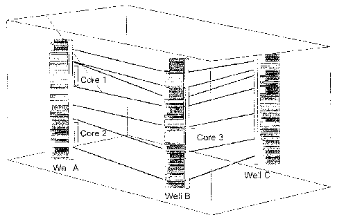
FIG. I is a schematic illustrationof.a.3-dimensional 'reservoir model made in
accordance with the present: invention which has three exemplary pseudocores
which
are correlated between Wellbores to create a stratigraphic model;
5- FIG. 2 is a. flowchart of a preferred embodiment of a method used in
constructing the
stratigraphie model of FIG. I;
FIG. 3A: shows a cores split into four segments, and FIG. 3B illustrates a
continuous.
detailed graphic core description of the core;
FIGS. 4A and 4B, respectively, show original traces from witeline. data and a
segment
of an interpretable borehole image MIMI was made from the wireline data;.
FIG. 5 shows exemplary geologic image facies A, B, and C generated from a
graphic
15. core description and a borehole image; and
FIG. 6 depicts the conversion of a borehole image into a graphic geologic
description.
referred to as a "pseudocore".
DETAILED DESCRIPTION OF THE INVENTION
The present invention provides arnethod for creating a stratigraphic model
from
borehole image data.and one or more cores,. Subsequently, a reservoir model
may be
made from the stratigraphicmodel.
FIQ..1 shows a 3-dimensional reservoir model which contains wellbores A, B,
and C.
Geologic interpretations or "master pseudocores" are shown adjacent each of
the
wellbores. The master psuedecores are based upon borehole images calibrated
across
one or more cored intervals. The three cores are associated with cored
intervals in the
wellbores. Connecting lines illustrate the correlation of reservoir zones or
facies
between pairs of weIlbores.
3
CA 02646666 2008-09-19
WO 2007/118136
PCT/US2007/066043
FIG. 2 is a flowchart which describes the steps taken in an exemplary method
of
constructing a stratigraphic model First, a core is obtained in step 110 from
a cored
interval within a wellbare. The core is examined and a detailed graphic core
description is created in step 120. Wireline data is then obtained in step 130
over an
interval of stratigraphic interest of the wellbore which also contains the
cored interval.
The cored interval is generally much smaller in length than the overall
interval of
stratigraphic interest of the wellbore for which additional stratigraphic
information is
sought. The wireline data includes a borehole image. This wireline data is
then
processed in step 140 into an interpretable borehole image.
The detailed graphic core description is compared with the portion of the
interpretable
borehole image which corresponds to the cored interval. Subsequently, a
catalogue of
geologic image facies is created in step 150. This catalogue of geologic image
fades
is then compared against the borehole image in step 160 to create a
preliminary
pseudocore for the interval of stratigraphic interest. A workstation is
preferably used
in step 170 to interactively examine the interpretable borehole image and the
preliminary pseudocore for the interval of stratigraphic interest to create a
master
pseudocore.
Second wireline data is obtained in step 180 from a second wellbore which
covers a
second interval of stratigraphic interest. The second wireline data includes a
second
borehole image. The second wireline data is processed into a second
interpretable
borehole image in step 190. The second borehole image is compared in step 200
with
the catalogue of geologic image facies to create a second preliminary
pseudocore for
the second interval of stratigraphic interest. The second interpretable
borehole image
is examined in step 210, preferably interactively with a computer workstation,
to
create a second master pseudocore for the second interval of stratigraphic
interest.
The master pseudocores are correlated between the wellbores to create a
stratigraphic
model in step 220. This stratigraphic model may then be used in building a
reservoir
model in step 230.
Optionally, more than one core may be used in developing an enhanced catalogue
of
geologic image fades. Detailed graphic core descriptions for these additional
cores
4
CA 02646666 2008-09-19
WO 2007/118136
PCT/US2007/066043
are compared with corresponding portions of interpretable borehole images to
create
the enhanced catalogue of geologic image facies. Again, this enhanced
catalogue of
geologic image facies is compared against borehole images to create
preliminary
pseudocores. The additional cores may come from first wellbore, the second
wellbore, or both. The above method may be extended such that a correlation is
done
between a number of wellbores in constructing the stratigraphic model. The
stratigraphic model is preferably a 3-dimensional model as is the reservoir
model.
However, the present method may also be useful in constructing 2-dimensional
models.
The aforementioned steps in constructing the stratigraphic model shall now be
described in greater detail.
Step 110: Obtaining Cores
Cores are taken from one or more intervals of interest in at least one of the
wellbores
A, B or C. Referring to Fla 1, two spaced apart cores and cored intervals are
shown
in wellbore A and a third core is shown in wellbore, B. in this example, no
cores are
taken from wellbore C. Core information from wellbores A and B can be
extrapolated to wellbore C, as will be described below. Corresponding to each
of the
coresis.a cored interval in the respective.wellbore from which the core was
obtained.
It is possible to utilize this method with only one core. However, more
preferably,
cores would be taken from each of the wellbores, Further, ideally one core
would be
taken from each reservoir zone in each wellbore. Typically, the cores are of
100-200
feet in length and 4-6 inches in diameter. As mentioned above, the cores
contribute to
creating the overall catalogue of geologic image facies..
5
CA 02646666 2008-09-19
WO 2007/118136
PCT/US2007/066043
Step 120: Examining Cote(s) and Creatitg Detailed Graphic Core
Descriptions
The core from step 110 is examined and a detailed graphic core description is
developed. FIG. 3A shows four adjacent and distinct segments of a core.
Typically,
each of the segments is approximately three feet in length. FIG. 3B
illustrates:a
continuous detailed graphic core description corresponding to the four
segments of
core. The graphic core description consists of a graphic s.ummary of physical
characteristics of the core. By way of example, and not limitation, these
characteristics may include lithology, grain size, physical structures and
other
attributes of the core. The process of creating a detailed graphic Core
description from
an interval of core is, well known to those skilled in the art of examining
geologic data
from Wells and will not be described in further detail.
Step 130: Obtaining Wireline Data Including Borehole Image Data
Wireline data is next, obtained for the welibore over an interval of
stratigraphic
interest. This interval of stratigraphic interest contains the smaller cored
interval from
which the core was extracted. Typically, these intervals of stratigraphic
interest are of
approximately 1000 to 5000 feet in length, Accordingly, this interval of
interoSOS:
20: many times the length of the cored interval.
Wireline data is obtained by running a wireline tool down the wellbore of
interest:
The Wireline data obtained may include, by way of example and not limitation,
borehole image data and 41 least a minimal suite of conventional well logs
(gamma
:25: ray, density, sonic, neutron, caliper, porosity, etc). This data is
preferably gathered in
digital format. A preferred image tool is Oil Based Micro Imager (0BMI)Tm
commercially available from Sehlumberger information Solutions of Houston,
Tekas,
Those skilled in the art will appreciate that other types of imaging may be
used as.
well with the present invention.
30.
6
CA 02646666 2008-09-19
WO 2007/118136
PCT/US2007/066043
Step 140: Processing Wireline Data into Interpretable Borehole Images
The wireline data, including the borehole image data of step 130, is
preferably
processed into a digital tile containing an interpretable borehole image
covering the
interval of stratigraphic interest. FIG. 4A shows a short segment, five
feet of a
much longer interval of borehole image data. This data is displayed as traces
in FIG.
4A. FIG. 4B shows these traces converted to an interpretable borehole image.
This
conversion is readily performed by commercially available software, such as
RecailTM
software available from PetrisTechnology, Inc. of Houston, Texas. Alternative
commercial software to create interpretable borehole images is available from
vendors
such as Schlumberger, Crocker Data Processing, TerraSciences and Techsia.
Preferably, the image of the entire interval of stratigrapbic interest is
contained within
a single data file. Although less preferred, the interval could be contained
on multiple
adjacent data files,
Step 145: (Optional) Plotting the Interpretable Borehole Images
Although not shown on the flowchart of FIG. 2, the digital file of the
interpretable
borehole image of step 140 is preferably plotted along side conventional well
log data
onto a long continuous piece of paper to create a plot of interpretable
borehole images
for the interval of sttatigraphic interest in the wellbore. It has been found
that
examination using the long continuous piece of paper is advantageous over
using a
computer workstation when examining the interpretable borehole image or
images.
Step 150: Creating a catalogue of Geologic thine Facies-,
The detailed graphic core.description of step 120 is compared to the plot of
the
interpretable borehole image of step 140 for the same depth interval as the
cored
interval of step 110. Key features and attributes are identified in the
interpretable
borehole imagd. Non-limiting examples of features and attributes may include
bedding, layering, image color, dipping or inclined surfaces, etc.
7
CA 02646666 2008-09-19
WO 2007/118136
PCT/US2007/066043
As a result, definitions of geologic image facies are created in the
interpretable
borehole image for the cored interval. For the purposes of this specification,
the term
"geologic image facies" shall refer to a geologic-classification of intervals
from
interpretable borehole image into categories (facies). These categories are
based on
attributes including image color, image texture and patterns, physical
structures and
other features visible in interpretable borehole images,
Referring to Ha 5, intervals 1-7 are identified from the graphic core
description.
Segments of the borehole image that correspond to these intervals 1-7, are
defined as
geologic image facies A, B, and C. For example, facies A is massive sandstone
and
occurs in intervals 1, 3 and 7. Facies B is shale and occurs in intervals 2, 4
and 6.
Facies=C is bedded sandstone and occurs in interval 5. Consequently, a
catalogue of
geologic image facies is defined to translate image character into geologic
interpretation.
Step 160: Assigning Geologic Image Facies in the Remainder of the
Interval of
Stratigraphic Interest
Referring to FIG. 6; a borehole image is shown on the left. Geologic image
facies are
assigned to the entire interval of interest of the borehole image using the
catalogue
established in step 150. For example, the top interval is shale and is
assigned facies B.
The next interval is assigned with facies C and so on. A graphical
representation of
the entire succession of geologic image facies is created using geologic
patterns to
represent each image facies. This graphical representation is referred to as a
preliminary "pseudocore" and is shown on the right side in Fla 6.
Step 170: Creating a Master Pseudocore Interpretation
The interpretable borehole image from step 140, for the entire of interval of
stratigraphic interest, is interactively examined using a computer workstation
with
commercially available image viewing software, such as Petris Recall. This
step
preferably includes interactively changing the vertical scale and dynamic
color scaling
of the images to emphasis subtle features. Furthermore, the software is
ideally used to
8
CA 02646666 2008-09-19
WO 2007/118136
PCT/US2007/066043
measure and record dipping bed surfaces and to identify faults and other
structural
features. Subsequently, the geologic description of the borehole images
(pseudocore)
of the entire interval of interest in the cored well in 160 is updated with
the additional
analysis to create a master pseudocore for all intervals of interest in the
wellbore.
Step 180: Obtaining Second Wireline Data
Wire! inc data is obtained from a second -wellbore covering a second interval
of
stratigraphic interest. This second wireline data again includes a borehole
image, and
preferably, a suite of conventional well logs as described in step 1.30.
Step 190: Processing Second Wireline Data
This second wireline data is then processed into a second interpretable
borehole
image. The second wireline data may or may not include a portion corresponding
to a
cored interval. If a core and core interval are available, this core and cored
interval
are available to enhance the catalogue of geologic image facies..
Step 200: Creating a second preliminary pseudocore
The second borehole image is compared to the existing catalogue of geologic
image
facies. As a result, a second preliminary pseudocore is created for the second
interval
of stratigraphic interest.
Step 210: Creating a Second Master Pseudocore
The second interpretable borehole image is interactively examined and compared
with
the second preliminary pseudocore. As a result, a .second master pseudocore is
developed for the second interval of stratigraphic interest. This second
master
pseudocore is created in a manner similar to that described above with respect
to step
170.
9
CA 02646666 2008-09-19
WO 2007/118136
PCT/US2007/066043
Step 220: Correlatina the Master Pseudocores from the Wellbores to
Create a. 3t
Dimensional Stratigraphic Model
Referring again to FIG, 1, zones of similar Character in the master
pseudocores are
correlated between wellbOres. This correlation is accomplished by recognizing
facies
or groups of facies that occur in the same vertical order in adjacent Wells.
As a simple
example, a series of facies A-C-B in one wellbore may be correlated with a
similar
set of fades. A-C-B in another Wellbore. Of course, actual geology is
typically much
more complex. However, the basic principles of correlating corresponding
Stratigraphie intervals are still applied. The geologic character represented
in the
psuedocores enables more precise stratigraphic correlation than is possible
using:
conventional wirehne log data without interpreted borehole images.
Stp2: Building a Reservoir Model from the Stratirraphic Model:
Subsequently, from the stiatigraphic Model or interpretation of step 220, a
reservoir
model may be eonstructed. This is accomplished by utilizing the correlated
zones of
similar character from step 220 as input for constructing 3-D reservoir bodies
using
commercially available software. This software may include GOCAD:, or PETREL
by
Schlumberger Geoquest.
In the event that additional cores are available, these cotes may be used to
further
define or improve the detailed comparisons of core character to interpretable
borehole
images perfOnned in step 160. These improved detailed comparisons can be
applied
to all intervals of interest in the master pseudoeore interpretations of step
200.
While in the foregoing specification this invention has been described in
relation to
certain preferred embodiments thereof; and many details have been set forth
for
purpose of illustration, it will be apparent to thosei:skilled in the art that
the invention
:30 is Susceptible to alteration and that certain Other details described
herein ca n vary
considerably without departing from the basic principles of the invention,