Note : Les descriptions sont présentées dans la langue officielle dans laquelle elles ont été soumises.
CA 02646830 2008-09-26
WO 2008/002126 PCT/NL2006/050146
1
Navigation device and method
for providing warnings for a speed trap
TECHNICAL FIELD
The present invention relates to a navigation device for providing warnings
when a detection point of a speed trap is approached. The invention further
relates to a
vehicle comprising such a navigation device and a method for providing
warnings
when a detection point of a speed trap is approached. Also, the present
invention relates
to a computer program and a data carrier.
STATE OF THE ART
Prior art navigation devices based on GPS (Global Positioning System) are well
known and are widely employed as in-car navigation systems. Such a GPS based
navigation device relates to a computing device which in a functional
connection to an
external (or internal) GPS receiver is capable of determining its global
position.
Moreover, the computing device is capable of determining a route between start
and
destination addresses, which can be input by a user of the computing device.
Typically,
the computing device is enabled by software for computing a "best" or
"optimum"
route between the start and destination address locations from a map database.
A "best"
or "optimum" route is determined on the basis of predetermined criteria and
need not
necessarily be the fastest or shortest route.
The navigation device may typically be mounted on the dashboard of a vehicle,
but may also be formed as part of an on-board computer of the vehicle or car
radio. The
navigation device may also be (part of) a hand-held system, such as a PDA or
telephone.
By using positional information derived from the GPS receiver, the computing
device can determine at regular intervals its position and can display the
current
position of the vehicle to the user. The navigation device may also comprise
memory
units for storing map data and a display for displaying a selected portion of
the map
data.
Also, it can provide instructions how to navigate the determined route by
appropriate navigation directions displayed on the display and/or generated as
audible
signals from a speaker (e.g. `turn left in 100 m'). Graphics depicting the
actions to be
CA 02646830 2008-09-26
WO 2008/002126 PCT/NL2006/050146
2
accomplished (e.g. a left arrow indicating a left turn ahead) can be displayed
in a status
bar and also be superimposed upon the applicable junctions/turnings etc. in
the map
itself.
It is known to enable in-car navigation systems to allow the driver, whilst
driving
in a car along a route calculated by the navigation system, to initiate a
route re-
calculation. This is useful where the vehicle is faced with construction work
or heavy
congestion.
It is also known to enable a user to choose the kind of route calculation
algorithm
deployed by the navigation device, selecting for example from a`Normal' mode
and a
`Fast' mode (which calculates the route in the shortest time, but does not
explore as
many alternative routes as the Normal mode).
It is also known to allow a route to be calculated with user defined criteria;
for
example, the user may prefer a scenic route to be calculated by the device.
The device
software would then calculate various routes and weigh more favourably those
that
include along their route the highest number of points of interest (known as
POIs)
tagged as being for example of scenic beauty.
According to EP 1.266.238 navigation devices comprising a speed trap detection
and warning system arranged to warn a driver about dangers, including speed
traps, are
known. Such a navigation device may comprise storage means configured to store
location data defining locations for a plurality of speed traps. A current
position of the
navigation device is compares to these locations and, depending on the
outcome, a user
may be alerted. Such speed traps may for instance be a point-to-point speed
trap.
It is an object of the invention to provide an improved speed trap warning
system.
SHORT DESCRIPTION
According to an aspect there is provided a navigation device for providing
warnings when a detection point of a speed trap is approached, the navigation
device
comprising a processor unit and a memory unit, the processor unit being
arranged to
communicate with the memory unit and to receive positional information from a
positioning device, the memory unit being arranged to comprise a speed trap
database,
comprising at least one detection point of a location of a speed trap, where
the
navigation device is further arranged to provide a warning when one of the at
least one
detection point is approached, characterised in that the memory unit is
further arranged
CA 02646830 2008-09-26
WO 2008/002126 PCT/NL2006/050146
3
to comprise at least a further detection point associated with at least one of
the stored
detection points, the further detection point and the associated detection
point both
relate to a same point to point speed trap, where the navigation device is
further
arranged to provide a warning when the further detection point is approached
or has
been passed. Such a navigation device provides a user with accurate
information about
point to point speed traps.
According to an embodiment, the navigation device is arranged to
- provide a warning that is a general speed trap warning when the detection
point is
approached in case no further detection point is associated with the detection
point that
is approached,
- provide a warning that is a first point to point warning in case the further
detection
point is associated with the detection point that is approached, and
- provide a warning that is a second point to point warning in case the
further detection
point is approached or has been passed. According to such an embodiment, the
navigation device provides different warnings for different situations, which
is
advantageous for a user.
According to an embodiment, the navigation device comprises a display, and
the warning may be a visual warning provided via the display or the navigation
device
comprises a speaker, and the warning may be an audible warning provided via
the
speaker, or the warning may be a combination of a visual and an audible
warning.
According to an embodiment, the navigation device is arranged to provide
speeding warnings in between the detection point and the further detection
point, if the
navigation device detects that a speed of the navigation device exceeds a
threshold
speed value, the threshold speed value being stored in the memory unit and
being
associated with a road segment in between the detection point and the further
detection
point. Such a navigation device provides additional information to a user
informing the
user about possible violation of the applicable speed limit. The speed may be
determined based on received positional information from the positioning
device.
According to an embodiment, the navigation device is arranged to provide a
speeding warning if a current speed of the navigation device exceeds the
threshold
speed value or may be arranged to provide a speeding warning if an average
speed of
the navigation device exceeds the threshold speed value. The average speed may
be
computed from the first detection point to the current position.
CA 02646830 2008-09-26
WO 2008/002126 PCT/NL2006/050146
4
According to an embodiment, the navigation device is arranged to compute an
advisory speed. This advisory speed may advise the user what speed to obey in
order to
prevent leaving the point to point speed trap controlled area to soon.
According to a further aspect there is provided a vehicle, comprising a
navigation device according to the above.
According to a further aspect there is provided a method for providing
warnings
when a detection point of a speed trap is approached, the method comprising:
- providing a speed trap database, comprising at least one detection point of
a
location of a speed trap,
- providing a warning when one of the at least one detection point is
approached, characterised by
- providing at least one further detection point associated with at least one
of the
stored detection points, the further detection point and the associated
detection point
both relating to a same point to point speed trap,
- providing a warning when the further detection point is approached or has
been passed.
According to a further aspect there is provided a computer program that, when
loaded on a computer arrangement, is arranged to perform the method described
above.
According to a further aspect there is provided a data carrier, comprising a
computer program according to the computer program described above.
SHORT DESCRIPTION OF THE DRAWINGS
Embodiments of the invention will now be described, by way of example only,
with reference to the accompanying schematic drawings in which corresponding
reference symbols indicate corresponding parts, and in which:
- Figure 1 schematically depicts a schematic block diagram of a navigation
device,
- Figure 2 schematically depicts a schematic view of a navigation device,
- Figure 3 schematically depicts a point to point speed trap,
- Fig. 4 schematically depicts a flow diagram according to an embodiment, and
- Fig. 5 schematically depicts a flow diagram according to an embodiment.
CA 02646830 2008-09-26
WO 2008/002126 PCT/NL2006/050146
DETAILED DESCRIPTION
Figure 1 shows a schematic block diagram of an embodiment of a navigation
device 10, comprising a processor unit 11 for performing arithmetical
operations. The
processor unit 11 is arranged to communicate with memory units that store
instructions
5 and data, such as a hard disk 12, a Read Only Memory (ROM) 13, Electrically
Erasable
Programmable Read Only Memory (EEPROM) 14 and a Random Access Memory
(RAM) 15. The memory units may comprise map data. This map data may be two
dimensional map data (latitude and longitude), but may also comprise a third
dimension
(height). The map data may further comprise additional information such as
information about petrol/gas stations, points of interest. The map data may
also
comprise information about the shape of buildings and objects along the road.
The processor unit 11 may also be arranged to communicate with one or more
input devices, such as a keyboard 16 and a mouse 17. The keyboard 16 may for
instance be a virtual keyboard, provided on a display 18, being a touch
screen. The
processor unit 11 may further be arranged to communicate with one or more
output
devices, such as a display 18, a speaker 29 and one or more reading units 19
to read for
instance floppy disks 20 or CD ROM's 21. The display 18 could be a
conventional
computer display (e.g. LCD) or could be a projection type display, such as the
head up
type display used to project instrumentation data onto a car windscreen or
windshield.
The display 18 may also be a display arranged to function as a touch screen,
which
allows the user to input instructions and/or information by touching the
display 18 with
his finger.
The speaker 29 may be formed as part of the navigation device 10. In case the
navigation device 10 is used as an in-car navigation device, the navigation
device 10
may use speakers of the car radio, the board computer and the like.
The processor unit 11 may further be arranged to communicate with a
positioning
device 23, such as a GPS receiver, that provides information about the
position of the
navigation device 10. According to this embodiment, the positioning device 23
is a
GPS based positioning device 23. However, it will be understood that the
navigation
device 10 may implement any kind of positioning sensing technology and is not
limited
to GPS. It can hence be implemented using other kinds of GNSS (global
navigation
satellite system) such as the European Galileo system. Equally, it is not
limited to
satellite based location/velocity systems but can equally be deployed using
ground-
CA 02646830 2008-09-26
WO 2008/002126 PCT/NL2006/050146
6
based beacons or any other kind of system that enables the device to determine
its
geographical location.
However, it should be understood that there may be provided more and/or other
memory units, input devices and read devices known to persons skilled in the
art.
Moreover, one or more of them may be physically located remote from the
processor
unit 11, if required. The processor unit 11 is shown as one box, however, it
may
comprise several processing units functioning in parallel or controlled by one
main
processor that may be located remote from one another, as is known to persons
skilled
in the art.
The navigation device 10 is shown as a computer system, but can be any signal
processing system with analog and/or digital and/or software technology
arranged to
perform the functions discussed here. It will be understood that although the
navigation
device 10 is shown in Fig. 1 as a plurality of components, the navigation
device 10 may
be formed as a single device.
The navigation device 10 may use navigation software, such as navigation
software from TomTom B.V. called Navigator. Navigator software may run on a
touch
screen (i.e. stylus controlled) Pocket PC powered PDA device, such as the
Compaq
iPaq, as well as devices that have an integral GPS receiver 23. The combined
PDA and
GPS receiver system is designed to be used as an in-vehicle navigation system.
The
embodiments may also be implemented in any other arrangement of navigation
device
10, such as one with an integral GPS receiver/computer/display, or a device
designed
for non-vehicle use (e.g. for walkers) or vehicles other than cars (e.g.
aircraft).
Figure 2 depicts a navigation device 10 as described above.
Navigator software, when running on the navigation device 10, causes a
navigation device 10 to display a normal navigation mode screen at the display
18, as
shown in Fig. 2. This view may provide driving instructions using a
combination of
text, symbols, voice guidance and a moving map. Key user interface elements
are the
following: a 3-D map occupies most of the screen. It is noted that the map may
also be
shown as a 2-D map.
The map shows the position of the navigation device 10 and its immediate
surroundings, rotated in such a way that the direction in which the navigation
device 10
is moving is always "up". Running across the bottom quarter of the screen may
be a
status bar 2. The current location of the navigation device 10 (as the
navigation device
CA 02646830 2008-09-26
WO 2008/002126 PCT/NL2006/050146
7
itself determines using conventional GPS location finding) and its orientation
(as
inferred from its direction of travel) is depicted by a position arrow 3. A
route 4
calculated by the device (using route calculation algorithms stored in memory
units 12,
13, 14, 15 as applied to map data stored in a map database in memory units 12-
15) is
5 shown as darkened path. On the route 4, all major actions (e.g. turning
corners,
crossroads, roundabouts etc.) are schematically depicted by arrows 5
overlaying the
route 4. The status bar 2 also includes at its left hand side a schematic icon
depicting
the next action 6 (here, a right turn). The status bar 2 also shows the
distance to the
next action (i.e. the right turn - here the distance is 190 meters) as
extracted from a
10 database of the entire route calculated by the device (i.e. a list of all
roads and related
actions defining the route to be taken). Status bar 2 also shows the name of
the current
road 8, the estimated time before arrival 9 (here 35 minutes), the actual
estimated
arrival time 22 (4.50pm) and the distance to the destination 26 (31.6Km). The
status bar
2 may further show additional information, such as GPS signal strength in a
mobile-
phone style signal strength indicator.
As already mentioned above, the navigation device may comprise input devices,
such as a touch screen, that allows the users to call up a navigation menu
(not shown).
From this menu, other navigation functions can be initiated or controlled.
Allowing
navigation functions to be selected from a menu screen that is itself very
readily called
up (e.g. one step away from the map display to the menu screen) greatly
simplifies the
user interaction and makes it faster and easier. The navigation menu includes
the option
for the user to input a destination.
The actual physical structure of the navigation device 10 itself may be
fundamentally no different from any conventional handheld computer, other than
the
integral GPS receiver 23 or a GPS data feed from an external GPS receiver.
Hence,
memory units 12- 15 store the route calculation algorithms, map database and
user
interface software; a processor unit 12 interprets and processes user input
(e.g. using a
touch screen to input the start and destination addresses and all other
control inputs)
and deploys the route calculation algorithms to calculate the optimal route.
`Optimal'
may refer to criteria such as shortest time or shortest distance, or some
other user-
related factors.
More specifically, the user inputs his start position and required destination
into
the navigation software running on the navigation device 10, using the input
devices
CA 02646830 2008-09-26
WO 2008/002126 PCT/NL2006/050146
8
provided, such as a touch screen 18, keyboard 16 etc.. The user then selects
the manner
in which a travel route is calculated: various modes are offered, such as
a`fast' mode
that calculates the route very rapidly, but the route might not be the
shortest; a`full'
mode that looks at all possible routes and locates the shortest, but takes
longer to
calculate etc. Other options are possible, with a user defining a route that
is scenic -
e.g. passes the most POI (points of interest) marked as views of outstanding
beauty, or
passes the most POIs of possible interest to children or uses the fewest
junctions etc.
The navigation device 10 may further comprise an input-output device 25 that
allows the navigation device to communicate with remote systems, such as other
navigation devices 10, personal computers, servers etc., via network 27. The
network
27 may be any type of network 27, such as a LAN, WAN, Blue tooth, internet,
intranet
and the like. The communication may b wired or wireless. A wireless
communication
link may for instance use RF-signals (radio frequency) and a RF-network.
Roads themselves are described in the map database that is part of navigation
software (or is otherwise accessed by it) running on the navigation device 10
as lines -
i.e. vectors (e.g. start point, end point, direction for a road, with an
entire road being
made up of many hundreds of such sections, each uniquely defined by start
point/end
point direction parameters). A map is then a set of such road vectors, plus
points of
interest (POIs), plus road names, plus other geographic features like park
boundaries,
river boundaries etc, all of which are defined in terms of vectors. All map
features (e.g.
road vectors, POIs etc.) are defined in a co-ordinate system that corresponds
or relates
to the GPS co-ordinate system, enabling a device's position as determined
through a
GPS system to be located onto the relevant road shown in a map.
Route calculation uses complex algorithms that are part of the navigation
software. The algorithms are applied to score large numbers of potential
different
routes. The navigation software then evaluates them against the user defined
criteria
(or device defaults), such as a full mode scan, with scenic route, past
museums, and no
speed camera. The route which best meets the defined criteria is then
calculated by the
processor unit 11 and then stored in a database in the memory units 12- 15 as
a
sequence of vectors, road names and actions to be done at vector end-points
(e.g.
corresponding to pre-determined distances along each road of the route, such
as after
100 meters, turn left into street x).
CA 02646830 2008-09-26
WO 2008/002126 PCT/NL2006/050146
9
As already mentioned above, the memory units 12 - 15 may comprise map data.
The map data may comprise additional information such as information about
petrol/gas stations, points of interest. The map data may also comprise
information
about the location of speed traps, such as point to point speed traps.
Point to point speed trap
A point to point speed trap PP is a speed trap comprising a first detection
point
Pl and a second detection point P2, as schematically depicted in Fig. 3. These
points
may also be referred to in this text as detection point Pl and further
detection point P2,
respectively.
The distance X between the first detection point Pl and the second detection
point P2 is known, for instance 3500 meters. The point to point speed trap PP
is
arranged to detect a vehicle V driving past the first detection point Pl . All
kinds of
techniques may be used to detect vehicle V driving past the first detection
point Pl.
Vehicle V may for instance be detected using electromagnetic sensors (not
shown)
being provided in the road. If vehicle V is detected, a first camera CAl
positioned at
the first detection point Pl is caused to take a picture of the vehicle V, for
instance of
the number plate of the vehicle V.
The point to point speed trap PP may further comprise a processing unit 90.
The
processing unit 90 may be any type of computer system, for instance comprising
an
input device 91, a memory unit 92 and a processor 93. The processor 93 is
arranged to
communicate with the memory unit 92 and the input device 91.
The picture taken by first camera CAl at the first detection point Pl is
transmitted to memory unit 92 via input device 91. The picture taken by the
first
camera CAl may be transmitted to the processing unit 90 using any kind of
technique,
such a simple wire, but also via any kind of network, for instance a wired or
wireless
network. Also stored in memory unit 92 is a time tl at which the picture is
taken, e.g.
10h30 and 23 seconds.
Vehicle V is detected in a similar way when it drives past the second
detection
point P2. Again, camera CA2, being positioned at the second detection point
P2, is
caused to take a picture of the vehicle. The picture taken at the second
detection point
P2 is stored in the memory unit 92 of the processing unit 90 together with a
time t2 at
which the picture is taken, e.g. 10h32 and 10 seconds.
CA 02646830 2008-09-26
WO 2008/002126 PCT/NL2006/050146
Of course many vehicles may drive past the point to point speed trap PP every
minute. Therefore, all pictures stored in memory unit 92 are analyzed and, for
instance
based on the number plates, pictures showing the same vehicle at the first and
second
detection point Pl and P2 are grouped together.
5 Next, the processor 93 computes an average speed of vehicle V in between the
first and second detection point Pl, P2 based on the time values of tl and t2
of the first
and second picture showing the same vehicle V, and the known distance X
between the
first and second detection point Pl, P2. In this case the average speed of
vehicle V is:
10 v = X_ 3500m = 32 7m / s= 117 8km / h
average t2 - tl 107s
~ ~ ~
as 10h32 and 10 seconds minus 10h30 and 23 seconds equals 107 seconds.
Next, this computed vaverage may be compared with a threshold speed value
stored in
memory unit 92. The threshold speed value may correspond with a maximum speed
for
the road segment in between detection point Pl and detection point P2. For
instance, in
case the maximum speed for that road segment is 100 km/h, the threshold speed
value
may be 100 km/h or 103 km/h. In case vaverage > vthreshola, the owner of
vehicle V may be
fined.
According to the prior art, speed trap warning systems provide a warning when
a user approaches a speed trap. Such a warning is generated in case the
navigation
detects that the navigation device 10 approaches a speed trap, locations of
which are
stored in a database accessible by the navigation device 10. Most of the speed
traps are
single standalone systems. For such standalone speed traps it is sufficient to
provide a
warning indicating that a speed trap is approached. The driver may slow down
his/her
vehicle and won't get a fine or ticket afterwards.
In a point to point speed trap the average speed is calculated in between the
first
and second detection point Pl, P2. So if the user speeds up his/her vehicle
after having
passed by the detection point Pl, like described above, he/she risks getting
fined for
driving too fast, because the average speed between the first and second
detection point
Pl, P2 was too high.
Embodiment 1
According to an embodiment, the memory units 12- 15 of the navigation device
10 may be arranged to comprise information about the position of a point to
point speed
CA 02646830 2008-09-26
WO 2008/002126 PCT/NL2006/050146
11
trap PP, i.e. information about a first detection point Pl at a first location
Ll and a
second detection point P2 at a second location L2. Also, information may be
stored
indicating that first and second detection points Pl, P2 are associated with
each other,
being part of the same speed trap, i.e. a point to point speed trap PP.
The navigation device 10 may be arranged to provide a user with a first
warning
or information signal when the user approaches the first detection point Pl.
The
warning or information signal may tell the user that he/she is entering a
point to point
speed trap controlled area.
This first warning may be a distinct sound or spoken message played over
speaker 29, and/or a visual warning, such as an icon displayed at display 18.
The navigation device 10 may further be arranged to provide a user with a
second warning or information signal when the user has passed the second
detection
point P2. The warning or information signal may tell the user that he/she has
left the
point to point speed trap controlled area.
Again, this second warning may be a distinct sound or spoken message played
over speaker 29, and/or a visual warning, such as an icon displayed at display
18.
According to a variant, for instance in case the first warning is at least a
visual
warning, the first warning may be displayed until the navigation device 10 has
left the
point to point speed trap controlled area. In that case, the second warning is
in fact
given by no longer providing the first warning.
This feature helps the user to prevent getting a fine or legal penalty because
of
the fact that he/she did not know that he/she was speeding up in a point to
point
controlled area of the road. Also, this helps to increases traffic safety in
such a zone by
constantly informing drivers about it.
According to this embodiment, the navigation device 10 provides a warning that
a point to point speed trap controlled area is entered and thus, that the user
shouldn't
speed up his/her vehicle after having passed the first detection point Pl.
By storing a first detection point Pl and a second detection point P2 a user
may
be given accurate information about the location of a point to point speed
trap PP. The
user may be given a warning when a point to point speed trap is approached, so
when
the first point Pl of the point to point speed trap PP is approached, but also
when the
point to point speed trap PP is exited, i.e. when the second detection point
P2 has been
CA 02646830 2008-09-26
WO 2008/002126 PCT/NL2006/050146
12
passed. Based on this embodiment, the user knows exactly if he/she is in or
outside the
point to point speed trap controlled area.
According to the prior art, as cited above, current navigation devices 10 give
a
warning when a user approaches a speed trap, such as a point to point speed
trap.
However, no indication is provided what type of speed trap is approached and
no
warning is given when the area controlled by the point to point speed trap is
left.
Based on this embodiment, the user will know that he/she should not speed up
his vehicle when having passed the first detection point Pl, and that he/she
should obey
the applicable maximum speed value, until he/she has left the point to point
controlled
area, so when he/she is given a warning or information signal informing that
the point
to point controlled area has been left.
Based on this embodiment, the memory units 12 - 15 of the navigation device
10 may be arranged to store a speed trap database that is improved over the
prior art.
The speed trap database does not only store first detection points Pl with
locations of
speed traps, but may also store second detection points P2 associated with at
least one
of the stored first detection points Pl, indicating that the first detection
point Pl refers
to a point to point speed trap which ends on the second detection point P2.
The memory units 12 - 15 may for instance comprise the following
information:
speed trap First detection point Second detection point
database P1 P2
1 Xl, Y1 -
2 X2, Y2 X2,2; Y2,2
3 X3, Y3 -
4 X4, Y4 X4,2; Y4,2
5 X5,1'5 -
According to this example, the speed trap database comprises five entries. A
first speed trap is located at a first location Xi, Y1, where X; and Y;
represent the
coordinates of the ith speed trap. It will be understood that many ways of
indicating the
location of a speed trap may be used and that X;, Y; is just an example of
such a
CA 02646830 2008-09-26
WO 2008/002126 PCT/NL2006/050146
13
representation. The first speed trap may be any type of speed trap, such as a
laser speed
trap, a radar speed trap and the like.
The second speed trap stored in the speed trap database refers to a point to
point
speed trap. This may be concluded because next to a first location Xz, Y2,
also a second
location Xz,z, Yz,z associated with the first location Xz, Y2 is stored. The
first location
X2, Yz represent the first detection point P1 of the point to point speed trap
PP, and the
second location Xz,z, Yz,z represents the second detection point P2 of the
point to point
speed trap PP.
According to this example, in general, the first location X;, Y; represent the
first
detection point Pl of the point to point speed trap PP, and the second
location X,,2, Yi,2
represents the second detection point P2 of the point to point speed trap PP.
So, additional information is added to the speed trap database indicating that
a
particular speed trap is a point to point speed trap. The software may be
arranged to
read this information and provide a warning informing the user the a point to
point
controlled area is entered or will be entered shortly and also inform him when
the users
has left or is about to leave the point to point controlled area.
Flow diagram embodiment 1
According to this embodiment the navigation device 10 may be arranged to
execute the actions as presented below and depicted in a flow diagram in Fig.
4.
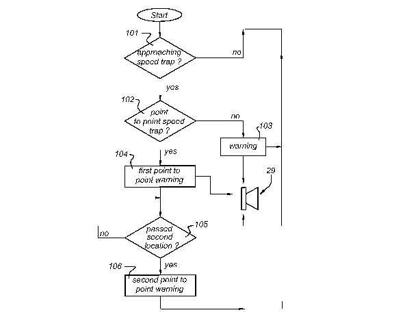
In a first action 101, the navigation device 10 may be arranged to determine
whether or not a speed trap is approached. This may be done in many ways, as
will be
understood by a skilled person. When determining whether or not a speed trap
is
approached the navigation device 10 may take into account the distance to the
speed
traps stored in the speed trap database, the direction of travel of the
navigation device
10, the direction in which the speed trap is orientated, the road segment the
speed trap
is located on, the road segment the navigation device 10 is traveling on etc.,
as will al
be understood by a skilled person. It will be understood that additional
information may
be stored in the speed trap database to allow such an assessment according to
action
101. For executing action 101 the navigation device 10 may use information
from the
speed trap database stored in memory units 12 - 15 and the positioning device
23, as
schematically depicted in Fig. 4.
CA 02646830 2008-09-26
WO 2008/002126 PCT/NL2006/050146
14
In case no speed trap is approached, the navigation device 10 may repeat
action
101. In case a speed trap is approached, the navigation device 10 may
determine what
type of speed trap is approached in an action 102. This may be done by reading
out
information about the type of speed trap from the speed trap database stored
in memory
12 - 15. According to the example provided above, this is done by checking if
a second
location X,,z, Y,,z is stored in the speed trap database stored in memory 12 -
15
associated with the first location X;, Y; of the speed trap that is being
approached.
In case the speed trap that is being approached is not a point to point speed
trap,
the navigation device 10 may continue with executing action 103, in which a
warning is
generated, for instance a general speed trap warning. This warning may be any
type of
warning, for instance an audible warning provided via speaker 29.
In case the speed trap being approached is a point to point speed trap, the
navigation device 10 may continue with executing action 104 in which a first
point to
point warning is generated. This warning may be any type of warning, for
instance an
audible warning provided via speaker 29. The first point tot point warning may
be
different from the warning generated in action 103, to inform the user that a
point to
point speed trap is being approached, so the user may adapt his/her driving
behavior
based on this.
Once the point to point warning is generated, the navigation device 10
continues
with executing action 105, in which it is determined if the navigation device
10 has
passed the second location X,,z, Y,,z being associated with the first location
X;, Y; of the
speed trap. As long as the second location X,,z, Y,,z has not been passed, the
navigation
device repeats action 105.
Once the second location X,,z, Y,,z has been passed, the navigation device 10
provides a second point to point warning. Again, this second point to point
warning
may be any type of warning, for instance an audible warning provided via
speaker 29.
The second point tot point warning may be different from the warning generated
in
action 103 and from the first point to point warning generated in action 104,
to inform
the user that the point to point controlled area has been left, so the user
may adapt
his/her driving behavior based on this.
The first point to point warning may be a spoken message, telling the user:
`You
are about to enter a point to point controlled area of the road', while the
second point
to point warning may be another warning, for instance telling the user `You
have left
CA 02646830 2008-09-26
WO 2008/002126 PCT/NL2006/050146
the point to point controlled area'. The first and second point to point
warnings may
also be two distinct sounds or tunes.
Of course, all warnings may also be visual warnings being provided via display
18, or a combination of a visible and audible warning.
5 The navigation device 10 may also be arranged to provide a`permanent'
warning constantly notifying the user that he/she is in a speed controlled
area. For
instance, in case the warning is a visual warning displayed via display 18,
the warning
may continuously being displayed until the second location X,,z, Y,,z has been
passed.
The second point to point warning may therefore simply be stopping providing
the first
10 point to point warning.
Embodiment 2
According to a second embodiment, the navigation device 10 may further be
15 arranged to provide speeding warnings in between the first detection point
Pl and the
second detection point P2, if the navigation device 10 detects that the user
is speeding,
i.e. violates the speed limit applicable for that particular road segment.
For instance, speeding warnings may be generated if the speed of the
navigation
device 10 (i.e. the vehicle), for instance determined based on information
received
using the positioning device 23, exceeds a threshold speed value stored in the
memory
unit 12 - 15 of the navigation device 10.
According to an other example, speeding warnings may be generated if the
average speed of the navigation device 10 (i.e. the vehicle), for instance
determined
based on information received using the positioning device 23, exceeds a
threshold
speed value stored in the navigation device 10.
In both examples, the threshold speed value stored in the memory unit 12 - 15
may correspond with a maximum speed for the road segment in between detection
point Pl and detection point P2. For instance, in case the maximum speed for
the road
segment is 100 km/h, the threshold speed value may be 100 km/h or 103 km/h.
According to the first example, the navigation device 10 constantly checks the
current velocity of the vehicle by comparing successive measurements of the
positioning device 23, as is usually constantly done in a navigation device
10. When
the velocity as determined exceeds a threshold speed value associated with the
road
segment and stored in the memory unit 12 - 15, a speeding warning may be
provided.
CA 02646830 2008-09-26
WO 2008/002126 PCT/NL2006/050146
16
According to the second example, the average velocity of the navigation device
in between the first and second detection points of the point to point speed
trap PP is
determined and compared with the threshold speed value. In order to do this,
the
navigation device 10 may be arranged to compute the average speed of the
navigation
5 device 10 at least at certain positions or constantly within the point to
point speed trap
controlled area and compares this average speed with the threshold speed value
associated with the road segment and stored in the memory unit 12 - 15.
So, after entering the point to point speed trap controlled area the
navigation
device 10 may be arranged to start calculating the average speed of the
navigation
10 device 10 in between the first detection point and the current position.
The navigation
device 10 may periodically provide speeding warnings if the average speed
exceeds the
threshold speed value.
It will be understood that also a combination of the two examples given above
may be employed, i.e. the navigation device 10 may be arranged to determine
both the
current speed as the average speed of the navigation device 10 and compare
these with
a threshold speed value. If one of the current /average speed is higher than
the threshold
speed value, the navigation device 10 may periodically give a speeding
warning.
Such a speeding warning may be a distinct sound or spoken message played over
speaker 29, and/or a visual warning, such as an icon displayed at display 18.
In case the
speeding warning is a spoken speeding warning, the spoken warning may for
instance
be: `You are still in point to point controlled area and you are driving too
fast' or `You
are still in point to point controlled area and you are driving too fast. The
speed limit
in this area is 100 km/h. '
Average speed indication
The speeding warnings may be a current speed indication or an average speed
indication and may be given periodically during the whole point to point
controlled
area. The period of the speeding warnings may be 5 to 20 seconds depending on
how
much the speed limit is exceeded, using a so called adaptive scheme. The
average
speed indication may also be given constantly, i.e. may be updated for each
new
position received from the positioning device 23.
For example, if the driver drives much too fast then the warnings may be
provided early within the point to point controlled area, to give the driver
time to
CA 02646830 2008-09-26
WO 2008/002126 PCT/NL2006/050146
17
correct the total average speed. If on the other hand the driver is speeding a
little, then
there is no need to annoy with the warnings too frequently or to early within
the point
to point controlled area.
The navigation device 10 may be arranged to display an average speed
indication, informing the user of the average speed from the first detection
point Pl to
the current position in between the first detection point Pl and the second
detection
point P2. Such an average speed indication may be computed by continuously
computing the average speed so far, using the time at which the first
detection point has
been passed, the location of the first detection point Pl, the current time
and the current
position as input. The average speed indication may be updated every second or
so.
In combination with the average speed indication a target average speed may be
displayed, for instance being the speed limit for the point to point
controlled area or the
threshold speed value associated with the point to point controlled area.
Also, in combination with the average speed indication, an advisory speed
v,,dv
may be displayed, informing the driver of an advised speed. When the point to
point is
entered, this advisory speed v,,dv may be the speed limit for the point to
point controlled
area or the threshold speed value vth .eshola associated with the point to
point controlled
area. However, during the travel from the first detection point Pl and the
second point
P2, the advisory speed v,,dv may change, as a result of the driving behavior
so far.
For instance, in case the navigation device 10 detects that it is half way the
point
to point controlled area, and the average speed so far exceeds the threshold
speed value
vthreshola, the advisory speed v,,dv is chosen such, that in case the user
follows the
advisory speed v,,dv, the average speed vaverage at the end of the point to
point controlled
area does not exceed the threshold speed value vthreshola.
The advisory speed v,,dv may be computed by first computing an advisory time
t~,dõ at which the navigation device 10 is to pass the second detection point
P2 may be
computed:
tadv = t, + x
Vthreshold
CA 02646830 2008-09-26
WO 2008/002126 PCT/NL2006/050146
18
where tl is the time of passing the first detection point Pl, X is the
distance
between the first and second detection point Pl, P2 and vth .eshola is the
threshold speed
value associated with the particular point to point speed trap.
The advisory speed v,,dv may be computed:
- L2 - Lcurrent
vadv ~
tadv - tcurrent
where t.dõ > te,,YYent and where L,,,YYent is the current location of the
navigation
device as for instance measured by the positioning device 23, L2 the location
of the
second detection point P2, tC1Yent the current time. In case tadv < tcurrent,
the speed of the
navigation device 10 is relatively slow. In order to prevent a negative
advisory speed
vadv, no further warnings are needed if tadv < t,.,,YYent.
Of course, all warnings and indications may also be provided as an audible
message via speaker 29.
In case the user is driving extremely slow or fast compared to the threshold
speed vthreshola, the advisory speed vadv may be very high or very low
respectively. In
order to prevent an advisory speed to be provided that is in conflict with the
law, the
vadv,sorymay be compared with an upper and/or lower speed limit for the
advisory
speed. The upper speed limit may be the same as the speed limit or threshold
speed and
the lower speed limit may correspond to the minimum allowable speed according
to the
law. This check may be part of action 107.
The advisory speed may be provided to the user by an advisory speed
indication, that may be passive or silent, for instance an icon in the corner
of the
display 18.
Flow diagram embodiment 2
Fig. 5 schematically depicts a flow diagram according to the second
embodiment. Fig. 5 is similar to Fig. 4, except for the fact that in between
action 104
and 105 an extra action 107 is provided.
Once action 104 is completed, the navigation device 10 may start a speeding
warning procedure. As explained above, this speeding warning procedure may
CA 02646830 2008-09-26
WO 2008/002126 PCT/NL2006/050146
19
comprise comparing the current speed to a threshold speed value and/or
comparing the
average speed to a threshold speed value.
Further embodiments
According to a further embodiment, a navigation device 10 is provided for
providing warnings when a detection point of a speed trap is approached,
the navigation device 10 comprising a processor unit 11 and a memory unit 12 -
15, the processor unit 11 being arranged to communicate with the memory units
12 -
and to receive positional information from a positioning device 23,
10 the memory unit 12 - 15 being arranged to comprise a speed trap database,
comprising at least one detection point Pl of a location of a speed trap,
where the navigation device 10 is further arranged to provide a warning when
one of the at least one detection point Pl is approached,
wherein navigation device 10 is arranged to provide speeding warnings from the
15 detection point Pl, if the navigation device 10 detects that a speed of the
navigation
device 10 exceeds a threshold speed value, the threshold speed value being
stored in the
memory unit 12 - 15.
Such a navigation device 10 provides speeding warnings when in a controlled
area. Also, the navigation device 10 may be arranged to first check if the
speed trap is a
point to point speed trap.
According to a variant, the speed is determined based on received positional
information from the positioning device 23.
According to a variant, the navigation device is arranged to provide a
speeding
warning if a current speed of the navigation device 10 exceeds the threshold
speed
value.
According to a variant, the navigation device 10 is arranged to provide a
speeding warning if an average speed of the navigation device 10 exceeds the
threshold
speed value. The average speed may be computed from the first detection point
to the
current position.
According to a variant, the navigation device 10 is arranged to compute an
advisory speed v,,dv. This advisory speed may advise the user what speed to
obey in
order to prevent leaving the point to point speed trap controlled area to
soon.
CA 02646830 2008-09-26
WO 2008/002126 PCT/NL2006/050146
According to a variant, the memory unit 12 - 15 is further arranged to
comprise
at least a further detection point P2 associated with at least one of the
stored detection
points Pl, the detection point Pl and the further detection point P2 both
relate to a same
point to point speed trap, where the navigation device 10 is further arranged
to stop
5 providing speeding warnings when the further detection point P2 is
approached or has
been passed. The navigation device may further be arranged to provide a
warning when
the further detection point P2 is approached or has been passed.
The embodiments described above may be used in all kinds of navigation device
10 10, such as portable, hand-held, built-in navigation device 10. Of course,
the
embodiments may also be used in a built-in board computer of a vehicle, or as
part of a
car radio system.
While specific embodiments of the invention have been described above, it
will be appreciated that the invention may be practiced otherwise than as
described. For
15 example, the invention may take the form of a computer program containing
one or
more sequences of machine-readable instructions describing a method as
disclosed
above, or a data storage medium (e.g. semiconductor memory, magnetic or
optical
disk) having such a computer program stored therein. It will be understood by
a skilled
person that all software components may also be formed as hardware components.
20 The descriptions above are intended to be illustrative, not limiting. Thus,
it will
be apparent to one skilled in the art that modifications may be made to the
invention as
described without departing from the scope of the claims set out below.