Note : Les descriptions sont présentées dans la langue officielle dans laquelle elles ont été soumises.
CA 02652627 2008-11-18
WO 2007/135671 PCT/IL2007/000608
Methods and Systems for Conv.nunicating and Displaying Points-Of-
Interest
FIELD AND BACKGROUND OF TBE INVENTION
The present invention relates to tracking systems and, in particular, it
concerns methods for displaying point-of-interest coordinate locations in
perspective images and for coordinate-based information transfer between
perspective images on different platforms.
By way of introduction, it is known to employ image processing to
identify and/or designate points of interest (or regions) in a wide range of
different applications. Examples include, but are not limited to,
identification
and treatment of diseased areas of crops, early identification and
extinguishing
of forest fires and image-processing-based navigation aids. In each of these
cases, it is conuiion for a point-of-interest ("PØ1.") to be identified in a
first
perspective view, for example from an aerial survey of crops or a specialized
airborne fire detection system. It is then desirable to identify the same
P.O.I. as
viewed from another platform, or from the same platform relocated at a new
viewpoint, for example, a crop-duster or fire-extinguishing aircraft. The
present
invention addresses the transfer of the P.O.I. information in a compact but
precise format to the second (or displaced) platform.
The present invention relies upon techniques of image registration
between images viewed at different viewing angles. These techniques per se
are well known in the art and will not be dealt with here in detail.
CA 02652627 2008-11-18
WO 2007/135671 PCT/IL2007/000608
Israeli Patent No. 111069 to Sroka et al., hereby incorporated by
reference for all purposes as if fully set forth herein, describes a method
and
system for marking object images acquired at high zooming by an airborne
imaging device on a reference image having a wide field of view of the scene.
This document does not address the question of information transfer between
different platforms.
When image-based tracking systems are used on multiple platforms,
information transfer between the platforms is complicated by the different
viewing directions of the separate platforms. Even when a point-of-interest,
or
point-of-interest-related information, is identified in the context of images
acquired from a first platform, this information cannot readily be used to
identify the point-of-interest or update the point-of-interest-related
information
in the context of images acquired from another platform.
U.S. Patent Application Publication No. 2002/0196248 to Kraus et al.,
hereby incorporated by reference for all purposes as if fully set forth
herein,
partially addresses this problem. Specifically, it describes a method for
sharing
visual information between a number of command and control ("C&C") units.
Although point-of-interest designation is performed in the context of a
perspective image, presentation of the information to other users is done in
the
context of a reference map. This renders it very difficult for the user to
integrate the available inforrnation with the real-time image interface.
In the context of head-up displays ("HUDs") and hehnet-mounted
displays ("IIMIDs"), it is laiown to present various symbols and other
2
CA 02652627 2008-11-18
WO 2007/135671 PCT/IL2007/000608
information spatially superimposed over corresponding objects in a scene
viewed directly by a pilot. In some cases, position information for the
symbols
may be derived on the basis of the aircraft position as indicated by an
inertial
navigation system ("INS") and/or global position system ("GPS"). The
resolution of such systems is in the order of degrees, and is hugely inferior
to
the resolution which can be achieved by image correlation in high-resolution
optical imaging systems.
There is therefore a need for methods for displaying point-of-interest
coordinate locations in perspective images and for coordinate-based
information transfer between perspective images on different platforms.
SUIy84ARY OF THE INVENTION
The present invention is a method for displaying point-of-interest
coordinate locations in perspective images and for coordinate-based
information transfer between perspective images on different platforms.
According to the teachings of the present invention there is provided, a
method for indicating, within a display of an arbitrary perspective view input
from an imaging device, a location based upon a coordinate within a shared
reference image, the method comprising: (a) providing a shared reference
image of a region overlapping at least part of the field of view of the
perspective view, the shared reference image having a defmed coordinate
system; (b) correlating the perspective view with the shared reference image
so
as to generate a mapping between the perspective view and the shared
3
CA 02652627 2008-11-18
WO 2007/135671 PCT/IL2007/000608
reference image; (c) employing the mapping to derive a location of a given
coordinate of the shared reference image within the perspective view; and
(d) indicating the location on the display.
According to a further features of the present invention, in a case where
the location of the given coordinate of the shared reference image lies
outside
the perspective view, there is indicated on the display a direction of angular
displacement of the imaging device required to bring the location within the
perspective view.
According to a fl.u-ther features of the present invention, there is
indicated a magnitude of angular displacement of the imaging device required
to bring the location within the perspective view.
According to a further features of the present invention, in a case where
the location of the given coordinate of the shared reference image lies
outside
the perspective view, the imaging sensor is automatically re-aligned to bring
the location within the perspective view.
According to a further features of the present invention, the coordinate
of the shared reference image is a location of crops requiring treatment.
According to a fiuther features of the present invention, the coordinate
of the shared reference image is a location of a forest fire.
According to a further features of the present invention, the coordinate
of the shared reference image is a location of a landing point for landing an
airbome platforn carrying the imaging device.
4
CA 02652627 2008-11-18
WO 2007/135671 PCT/IL2007/000608
According to a further features of the present invention, the correlating
includes: (a) correlating the perspective view with a reference view having a
field of view wider than the perspective view so as to generate a first
mapping
transformation; and (b) correlating the reference view with the shared
reference
image so as to generate a second mapping transformation.
According to a further features of the present invention, the coordinate
system is a geographical coordinate system.
There is also provided, according to the teachings of the present
invention, a method for transferring information between two users viewing a
common region of interest from different viewing directions, each user viewing
the region of interest as a perspective view derived from an image sensor and
presented on a display, the method comprising: (a) for each user: (i)
providing
a shared reference image of a region overlapping at least part of the field of
view of the perspective view, the shared reference image having a defined
coordinate system, and (ii) correlating the perspective view with the shared
reference image so as to generate a mapping between the perspective view and
the shared reference image; (b) inputting from the first user a location
within
the first user's perspective view designated as a point-of-interest location;
(c) processing the input location, by use of the first user's mapping, to
derive a
coordinate in the shared reference image corresponding to the point-of-
interest
location; (d) processing the coordinate, by use of the second user's mapping,
to
derive a location of the coordinate within the second user's perspective view;
and (e) indicating the point-of-interest location on the second user's
display.
5
CA 02652627 2008-11-18
WO 2007/135671 PCT/IL2007/000608
According to a further features of the present invention, the correlating
iilcludes: (a) correlating the perspective view with a reference view having a
field of view wider than the perspective view so as to generate a first
mapping
transformation; and (b) correlating the reference view with the shared
reference
image so as to generate a second mapping transformation.
According to a fiu-ther features of the present invention: (a) a second
user inputs a location within the second user's perspective view designated as
a
second point-of-interest location; (b) the input location is processed, by use
of
the second user's mapping, to derive a coordinate in the shared reference
image
corresponding to the second point-of-interest location; (c) the coordinate is
processed, by use of the first user's mapping, to derive a location of the
coordinate within the first user's perspective view; and (d) the point-of-
interest
location is indicated on the first user's display.
According to a further features of the present invention, the processing
the input location is performed using a processing system at a first location,
and
wherein the processing the coordinate is performed using a processing system
at a second location, the method further comprising transmitting the
coordinate
from the first location to a second location;
According to a further features of the present invention, the transmitting
is performed wirelessly.
According to a further features of the present invention, the transmitting
includes transmitting additional information relating to a point-of-interest
at the
point-of-interest locatioii..
6
CA 02652627 2008-11-18
WO 2007/135671 PCT/IL2007/000608
According to a further features of the present invention, the coordinate
system is a geographical coordinate system.
There is also provided, according to the teachings of the present
invention, a system for indicating a location based upon a coordinate defined
relative to a shared reference image, the system comprising: (a) an imaging
sensor; (b) a display; (c) a display driver for receiving images from the
image
sensor and displaying the images on the display; (d) a data storage device for
storing data corresponding to a shared reference image of a region at least
partially overlapping a field of view of the image sensor, the shared
reference
image having a defined coordinate system; and (e) a processing system
associated with the imaging sensor, the data storage device and the display
driver, the processing system being configured for: (i) correlating a
perspective
view generated by the imaging sensor with the shared reference image so as to
generate a mapping between the perspective view and the shared reference
image; (ii) employing the mapping to derive a location of a given coordinate
of
the shared reference image within the perspective view; and (iii) actuating
the
display driver to indicate the location in the context of the images on the
display.
According to a further features of the present invention, there is also
provided a communication interface associated with the processing system and
configured for receiving the coordinates from a point-of-interest designating
source.
7
CA 02652627 2008-11-18
WO 2007/135671 PCT/IL2007/000608
According to a further features of the present invention, the imaging
sensor has a given operative field of view, and wherein the processing system
is configured for correlating the perspective view with the shared reference
image by: (a) correlating the perspective view with a reference view having a
field of view wider than the given operative field of view so as to generate a
first mapping transformation; and (b) correlating the reference view with the
shared reference image so as to generate a second mapping transformation.
According to a ftu-ther features of the present invention, there is also
provided an input device associated with the display driver for user
designation
of a point-of-interest location within the perspective view.
According to a further features of the present invention, the processing
system is further configured for employing the mapping to derive a coordinate
in the shared reference image corresponding to a point-of-interest location
designated by use of the input device.
According to a further features of the present invention, there is also
provided an imaging sensor controller configured for controlling at least a
direction of regard of the imaging sensor, wherein the processing system is
further configured to activate the imaging sensor controller such that, in a
case
where the location of the given coordinate lies outside the field of view of
the
imaging sensor, the imaging sensor controller automatically re-aligns the
imaging sensor to bring the location within the field of view.
There is also provided, according to the teachings of the present
invention, a method for providing a point-of-interest direction vector to an
8
CA 02652627 2008-11-18
WO 2007/135671 PCT/IL2007/000608
automated system, the method comprising: (a) providing an imaging sensor
mounted in known geometric relation to at least part of the automated system;
(b) deriving from the imagirig sensor a perspective view; (c) providing a
shared
reference image of a region at least partially overlapping a field of view of
the
perspective view, the shared reference image being associated with a defined
coordinate system; (d) correlating the perspective view with the shared
reference image so as to generate a mapping between the shared reference
image and the perspective view; (e) employing the mapping to derive a location
of a point-of-interest coordinate from the shared reference image within the
perspective view; and (f) providing to the automated system a point-of-
interest
direction vector indicative of a direction from the at least part of the
automated
system to the point-of-interest.
According to a further features of the present invention, the automated
system includes a helmet wom by a user, -,vherein the image sensor is provided
mounted on the helmet.
According to a further features of the present invention, the automated
system further includes a head-up display, the method further comprising
displaying a symbol visible to a user aligned with the point-of-interest
direction
vector.
According to a further features of the present invention, the head-up
display is implemented as a helmet-mounted display.
According to a fi.u-fl.ler features of the present invention, in a case where
the location of the given coordinate in the shared reference image lies
outside
9
CA 02652627 2008-11-18
WO 2007/135671 PCT/IL2007/000608
the perspective view, there is indicated on the head-up display a direction of
angular displacement of the imaging device required to bring the location
within the perspective view.
According to a further features of the present invention, there is
indicated on the head-up display a magnitude of angular displacement of the
imaging device required to bring the location within the perspective view.
According to a further features of the present invention, the automated
system includes an optical sight, the method further comprising displaying a
symbol visible to a user aligned with the point-of-interest direction vector.
According to a further features of the present invention, the automated
system includes a head-up display, the method further comprising displaying a
symbol visible to a user aligned with the point-of-interest direction vector.
According to a further features of the present invention, the automated
system includes a hehnet-mounted display, the metliod further comprising
displaying a symbol visible to a user aligned with the point-of-interest
direction
vector.
According to a fiuther features of the present invention, the automated
system includes an aimable device, the method further comprising
automatically aligning the aimable device with the point-of-interest direction
vector.
According to a further features of the present invention, the automated
system includes a navigatable device, the method further comprising
CA 02652627 2008-11-18
WO 2007/135671 PCT/IL2007/000608
employing the point-of-interest direction vector to navigate the navigatable
device to the point-of-interest.
According to a further features of the present invention, the automated
system includes an inertial navigation system, the method further comprising
employing the point-of-interest direction vector to correct errors of the
inertial
navigation system.
According to a fixrther features of the present invention, the automated
system includes an imaging sensor controller configured for controlling a
direction of regard of at least the imaging sensor, the method further
comprising, in a case where the location of the given coordinate in the shared
reference image lies outside the field of view of the imaging sensor,
activating
the imaging sensor controller to automatically re-align the imaging sensor to
bring the location within the field of view.
There is also provided, according to the teachings of the present
invention, an apparatus for providing a point-of-interest direction vector to
an
automated system, the point-of-interest being designated by a coordinate in a
shared reference image, the apparatus comprising: (a) an imaging sensor
mounted in known geometric relation to at least part of the automated system;
(b) a data storage device for storing data corresponding to a shared reference
image of a region at least partially overlapping a field of view of the image
sensor, the shared reference image having a defmed coordinate system; (c) an
input arrangement for inputting coordinates in the shared reference image of
the point-of-interest; and (d) a processing system associated with the imaging
11
CA 02652627 2008-11-18
WO 2007/135671 PCT/IL2007/000608
sensor, the data storage device, the input arrangement and the automated
system, the processing system being configured for: (i) correlating a
perspective view generated by the imaging sensor with the shared reference
image so as to generate a mapping between the perspective view and the shared
reference image; (ii) employing the mapping to derive a location of an input
coordinate from the shared reference image within the perspective view; and
(iii) providing to the automated system a point-of-interest direction vector
indicative of a direction from the at least part of the automated system to
the
point-of-interest.
According to a further features of the present invention, the automated
system includes a helmet worn by a user, wherein the image sensor is mounted
on the helmet.
According to a fiutb.er features of the present invention, the automated
systein further includes a head-up display, the automated system being
coiifigured to provide a symbol visible to a user aligned with the point-of-
interest direction vector.
According to a further features of the present invention, the head-up
display is implemented as a helmet-mounted display.
According to a further features of the present invention, the automated
system includes an optical sight, the automated system being configured to
provide a symbol visible to a user aligned with the point-of-interest
direction
vector.
12
CA 02652627 2008-11-18
WO 2007/135671 PCT/IL2007/000608
According to a further features of the present invention, the automated
system includes a head-up display, the automated system being configured to
provide a symbol visible to a user aligned with the point-of-interest
direction
vector.
According to a further features of the present invention, the automated
system includes a helmet-mounted display, the automated system being
configured to provide a symbol visible to a user aligned with the point-of-
interest direction vector.
According to a further features of the present invention, the automated
system includes an aimable device, the automated system being configured to
automatically align the aimable device with the point-of-interest direction
vector.
According to a further features of the present invention, the automated
system includes a navigatable device, the automated system being configured
to employ the point-of-interest direction vector to navigate the navigatable
device to the point-of-interest.
According to a further features of the present invention, the automated
system includes an inertial navigation system, automated system being
configured to employ the point-of-interest direction vector to correct errors
of
the inertial navigation system.
According to a further features of the present invention, there is also
provided an imaging sensor controller configured for controlling a direction
of
regard of at least the imaging sensor, wherein the processing system is
further
13
CA 02652627 2008-11-18
WO 2007/135671 PCT/IL2007/000608
configured to act-uate the imaging sensor controller such that, in a case
where
the location of the given coordinate in the shared reference image lies
outside
the field of view of the imaging sensor, the imaging sensor controller
automatically re-aligns the imaging sensor to bring the location within the
field
of view.
BRIEF DESCRIl'TION OF THE DRAWINGS
The invention is herein described, by way of example only, with
reference to the accompanying drawings, wherein:
FIG. 1 is a schematic representation of a system, constructed and
operative according to the teachings of the present invention, for providing
coordinate-based information transfer between platforms viewing objects in
different perspective views and displaying the information in the context of
the
different perspective views;
FIG. 2 is a schematic set of perspective and orthogonal views for two
users illustrating the principles of the method of information transfer
according
to the present invention;
FIG. 3 is a flow diagram illustrating the steps of an implementation of
the method of Figure 2;
FIG. 4 is a schematic representation of a two-step implementation of a
correlation calculation from the method of Figure 3;
FIG. 5 is a simplified unidirectional implementation of the method of
Figure 3;
14
CA 02652627 2008-11-18
WO 2007/135671 PCT/IL2007/000608
FIG. 6A is a schematic representation of a first application of the present
invention for providing image-derived point-of-interest direction vectors to
an
automated system based on point-of-interest coordinate information, wherein
the point-of-interest direction is indicated to a user on a head-up display;
FIG. 6B is a schematic representation of a second application of the
present invention for providing image-derived point-of-interest direction
vectors to an automated system based on point-of-interest coordinate
information, wherein the point-of-interest direction is used for automatically
aiming an aimable device at the point-of-interest;
FIG. 6C is a schematic representation of a third application of the
present invention for providing image-derived point-of-interest direction
vectors to an automated system based on point-of-interest coordinate
information, wherein the point-of-interest direction is used for navigating a
navigatable device to the point-of-interest; and
FIG. 7 is a flow diagram illustrating the operation and corresponding
methods of the applications of Figures 6A-6C.
DESCRIPTION OF THE PREFERRED EMBODIMENTS
The present invention is a method for displaying point-of-interest
coordinate locations in perspective images and for coordinate-based
information transfer between perspective images on different platforms.
CA 02652627 2008-11-18
WO 2007/135671 PCT/IL2007/000608
The principles and operation of methods according to the present
invention may be better understood with reference to the drawings and the
accompanying description.
Referring now to the drawings, Figures 1-4 illustrate a system and
corresponding method according to the teachings of the present invention for
transferring information between two users viewing a common region of
interest from different viewing directions, either simultaneously or
sequentially. The system and method of the present invention are applicable to
a wide range of civilian and military applications. By way of non-limiting
examples, the invention may be used to advantage in applications of screening
fields and orchards for disease-affected or infested crops or trees, and for
screening large areas of woodlands for forest fires. In either case, special
detection equipment may be used initially on an airborne or otherwise elevated
platform, and the point-of-interest locations thus identified can then be used
for
precise visual cuing of crop-dusting or fire-extinguishing aircraft which
carry
simple imaging systems without sophisticated detection equipment. Details of
these and other applications will be better understood by one ordinarily
skilled
in the art on the basis of the following detailed description.
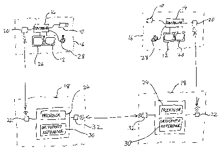
The typical structural features of the system are shown in Figure 1. Each
user views an image of the region of interest derived from an image sensor 10
and presented on a display 12 by a controller unit 14. In the case of mobile
platforms 16, the images are generally relayed to a corresponding command
and control ("C&C") unit 18, for example via wireless transceivers 20 and 22,
16
CA 02652627 2008-11-18
WO 2007/135671 PCT/IL2007/000608
for processing by a processor system 24. Controller unit 14 typically operates
an optical zoom of image sensor 10 for selectively generating views with
relatively wide field of view (FOV) and relatively narrow FOV. A"frozen"
wide angle view is optionally displayed on a second display 26, preferably
with
a frame indicating the region of the zoomed view currently being displayed on
display 12 to facilitate user orientation. A similar system and various
additional
preferred features for operation of the system are described in the
aforementioned Israeli Patent No. 111069.
Each user is also preferably provided with an input device 28 for
designating a point of interest or "target" location in the perspective view
shown on display 12. Each C&C unit 18 is also provided with reference data 30
corresponding to a shared reference image of a region overlapping at least
part
of the field of view of the perspective view of image sensor 10. The shared
reference image is "shared" in the sense that it is available to each C&C unit
and has a defmed coordinate system which forms the basis for a concise
communication format between the platforms. In certain preferred examples,
the coordinate system is a geographical coordinate system, typically
corresponding to the standard longitude-latitude or "north-south" coordinate
system defined globally across the surface of the Earth. Finally in structural
terms, the C&C units 18 are preferably in communication via a wireless data
communication system, such as a data-link system, represented by transceivers
32.
17
CA 02652627 2008-11-18
WO 2007/135671 PCT/IL2007/000608
Figure 2 illustrates the relationship between the at least two, and
typically three, images/views used by each platform-C&C subsystem.
Specifically, there are shown a real-time detailed narrow FOV perspective
image 40a, a frozen wide-angle perspective image 42a and a shared reference
image 44a. The right side of Figure 2 shows corresponding views 40b, 42b and
44b for a second platform-C&C subsystem. It will be immediately apparent
that, although views 40a and 40b show several common objects, the objects are
viewed at different angles and appear in different parts of the view. As a
result,
a user of the first subsystem would not generally be able to convey accurately
to the user of the second subsystem the position of any designated point-of-
interest.
The method of the present invention as illustrated in Figure 3 addresses
this problem as follows. Firstly, for each subsystem, the perspective view
40a,
40b is correlated with the corresponding shared reference image 44a, 44b,
respectively, so as to generate a mapping between them (step 50). The mapping
is an invertible transformation, typically in the form of a matrix of
conversion
coefficients, which can be used to map any point on the perspective view to a
corresponding point on the shared reference image and, in its inverted form,
vice versa. The techniques for correlating photographic images with differing
viewing directions are known iui the art, and are described directly and by
reference to other documents in the aforementioned U.S. Patent Application
Publication No. 2002/019624$. In the case of a real-time image from an image
18
CA 02652627 2008-11-18
WO 2007/135671 PCT/IL2007/000608
sensor 10, the mapping is dynamically changing and requires updating or
recalculating at intervals depending upon the rate at which the image changes.
The first user then inputs a location within his perspective view 40a
designated as a point-of-interest location 46 (step 52). This point-of-
interest
location 46, defined relative to the view 40a, is transmitted to processing
system 24 which derives, by use of the first user's mapping, a coordinate
corresponding to the point-of-interest location, marked as 46 in the
orthogonal
view 44a of Figure 3 (step 54). Optionally, in the case that the users are
associated with separate C&C units, this coordinate is then transmitted,
preferably wirelessly, from the first C&C unit to at least a second C&C unit
at
another location (step 56). Clearly, in the case where both users are
associated
with the same C&C unit, this transmission is usually unnecessary. The
processing system 24 of the second C&C unit then derives, by use of the
second user's inverted mapping, a location of the coordinate within the second
user's perspective view 40b (step 58) and transmits this position to
controller
14 for display as point-of-interest location 46 in the context of the second
user's display 40b (step 60). In most preferred implementations, this process
is
fully bi-directional, allowing each user to both designate point-of-interest
locations which are made visually available to other users and to receive
visual
indications of point-of-interest locations designated by other users.
It will be appreciated that this method offers profound advantages. First
and foremost, it allows sharing of information between users viewing objects
from different vantage points in an intuitive and precise manner. Furthermore,
19
CA 02652627 2008-11-18
WO 2007/135671 PCT/IL2007/000608
communication between the C&C units is extremely concise, requiring only a
set of coordinates to specify location, optionally accompanied by other
textual
information to identify the nature of the point-of-interest or specify
associated
information. The same transmitted information can be used by multiple
platforms with different viewing directions, allowing each image display to
indicate clearly and precisely the point-of-interest position within the
corresponding perspective view. These and other advantages of the present
invention will be further understood from the detailed description below.
Before proceeding further, it will be useful to defme certain terminology
as used herein in the description and claims. Firstly, the word "perspective"
is
used herein to refer to any non-orthogonal viewing direction. Thus, when two
views are described as "different perspective views", it is unplied that they
have non-coincident viewing directions.
In a further issue of terminology, reference is made herein in the
description and claims to an shared reference image which is a photographic
representation of the region of interest. The shared reference image is
"shared"
in the sense that it is available to each C&C unit and has a commonly defined
coordinate system which forms the basis for a concise communication format
between the platforms. In certain preferred examples, the coordinate system is
a geographical coordinate system, typically corresponding to the standard
longitude-latita.de or "north-south" coordinate system defined globally across
the surface of the Earth.
CA 02652627 2008-11-18
WO 2007/135671 PCT/IL2007/000608
The term "photographic representation" is used herein to refer to a real
or simulated image which simulates the properties of an image generated by a
corresponding type of image sensor. Thus, the photographic representation
typically approximates to an aerial photograph taken at visible wavelengths.
In
certain cases, a shared reference image approximating to a thermal aerial
photograph may be used. The different platforms may employ different types
of imaging sensors, and the photographic representation need not be of the
same image type. Thus, the present invention may be used for designating a
point-of-interest position identified in a visible wavelength image and then
displaying the point-of-interest position in the context of a thermal image,
or
the reverse.
The term "platform" is used herein in the description and claims to refer
to any platform from which a perspective view of a region of interest can be
obtained. It should be noted that the present invention is not limited to
airborne
platforms, and can equally be used where some or all of the image sensors are
located on other platforms such as observation towers or look-out points. It
should also be noted that the platform need not be a manned platform. In the
case of an unmanned platform, such as an unmanned aerial vehicle ("UAV"),
the user displays and input device are typically located at the corresponding
C&C unit.
According to a ftu-ther optional feature, if the current field of view of the
zoomed-in image sensor image does not include the point-of-interest location,
the system provides cues to the user or otherwise assists in identifying the
21
CA 02652627 2008-11-18
WO 2007/135671 PCT/IL2007/000608
required point-of-interest. In a simple implementation, the controller 14 may
be
configured to generate an arrow indicative of a direction, and optionally
angular displacement, in which the camera must be deflected in order to bring
the point-of-interest location into view. Additionally, or altematively,
controller 14 may be automatically, or manually, actuated to redirect and/or
zoom-out the image sensor so as to bring the point-of-interest location into
the
field of view.
As mentioned earlier, preferred configurations of a system for
implementing the present invention typically employ a frozen wide-angle
image in addition to the zoomed-in current image. This wide-angle image is
often necessary to provide sufficient data for reliable correlation with the
shared reference image. As a result, certain preferred implementations of the
present invention perform the correlation step 50 as a two-step correlation as
illustrated in Figure 4. Specifically, the narrow FOV image 40a is correlated
with the wide FOV image 42a to generate a first mapping transformation TI,
and the wide FOV image 42a is correlated with the shared reference image 44a
to generate a second mapping transformation T2. In this case, the reverse
transformation to generate a location within the image from an input
coordinate
will also be a two-step transformation.
While this two-step correlation is believed to be the preferred
implenientation for high resolution applications, it should be noted that a
single-step correlation is also within the scope of the invention.
Specifically,
for many applications, the resolution of the wide FOV image, optionally
22
CA 02652627 2008-11-18
WO 2007/135671 PCT/IL2007/000608
magnified for display to the user by digital zoom techniques, may provide
sufficient resolution for point-of-interest desi.gnation while simultaneously
containing sufficient features for direct correlation with the orthogonal
reference.
Parenthetically, it should be noted that the point-of-interest location may
designate an object whi.ch is either indiscernible or does not appear at all
in one
or both of the frozen wide FOV image and the shared reference image. For
example, in the images shown in Figure 2, the point-of-interest location 46
designates the current position of a vehicle on fire which was not present in
the
10, frozen view 42a or in the orthogonal reference 44a. So long as sufficient
content remains similar between the images to allow effective correlation of
the
images, this does not interfere with implementation of the method of the
present invention.
It should be noted that correlation step 50 does not have to be done for
all users prior to designation. In fact, as mentioned earlier, the correlation
"step" is typically a continuously performed process which maintains
correlation between a real-time image and the reference shared reference
image. If the correlation is kept updated at all times, only the
transformation
calculations need be performed during conversion between perspective and
coordinate frames of reference. As a result, the transfer of information
between
platforms can be achieved almost instantly in real-time.
In some cases, the point-of-interest location data may be used by a
system which was not in visual contact with the point-of-interest at the time
the
23
CA 02652627 2008-11-18
WO 2007/135671 PCT/IL2007/000608
point-of-interest was designated. One example of such an application would be
in aerial firefighting where advanced airborn.e thermal detection equipment
may be used for early identification of a center of a forest fire before it
could be
identified by video imaging and/or for planning of a strategy to prevent
spread
of the fire. Other firefighting aircraft carrying relatively simple imaging
systems may then be dispatched to try to implement the strategy and control
the
fire. In this context, an exact coordinate location established by the
detection
equipment can be designated on the video display of the firefighting aircraft
by
the method of the present invention to facilitate rapid and precise
identification
of the point-of-interest location.
Referring now to Figure 5, it should be noted that a simplified
unidirectional implementation of the method of the present invention may be
used in any circumstances where a point-of-interest location is known in
coordinate form from any source. The simplified iinplementation requires the
same correlation 50 of the perspective iniage from each platform to the shared
reference image as discussed above. Then, after input of the point-of-interest
coordinates (step 70), the inverse mapping and display steps 58 and 60 are
performed as above.
Referring now additionally to Figures 6 and 7, it should be noted that the
present invention is not limited to displaying points-of-interest in the
context of
an image. The ability to process point-of-interest coordinates using image
correlation to accurately locate a point-of-interest in an arbitrary
perspective
image may be used to advantage to provide a point-of-interest direction vector
24
CA 02652627 2008-11-18
WO 2007/135671 PCT/IL2007/000608
in various automated applications even where no image is displayed to a user.
A number of non-limiting examples will now be discussed with reference to
Figures 6A-6C and 7.
Referring first to Figure 6A, this shows a case of a helmet system
enhanced according to the teachings of the present invention. Specifically,
there is shown a helmet 80 which supports a small forward-looking camera 82
for visible or IR wavelengths. According to the teachings of the present
invention, the images from camera 82 are downloaded to a suitable processing
system (such as the C&C unit 18 of Figure 1) and are processed to derive the
correlation mapping for the current perspective view (step 90 in Figure 7).
Using this mapping, a point-of-interest coordinate (input at step 92) is
converted to a position within the field of view of camera 82 (step 94) and
hence, according to the predefined camera geometry, to a point-of-interest
direction vector indicative of the viewing direction of the point-of-interest
relative to the helmet (step 96). The point-of-interest is then preferably
indicated to the user as a symbol displayed by a head-up display (HUD)
superimposed upon the user's direct view of the real scene (step 98). Most
preferably, the HUD is a helmet-mounted display (I-EVM) 84 (Figure 6A).
Parenthetically, it should be noted that the camera 82 of these automated
system examples may either be in fixed geometrical relation to at least part
of
the automated system, or may be gimbaled or otherwise mobile so long as there
is a suitable measurement system for determining the geometrical relationship
between the current camera FOV parameters and the relevant part of the
CA 02652627 2008-11-18
WO 2007/135671 PCT/IL2007/000608
automated system. By way of example, if a helmet position tracking system is
used, the point-of-interest direction relative to a moving platform on which
the
helmet user is traveling can also be deduced. This allows display of the point-
of-interest on a cockpit-mounted HUD.
Turning now to Figure 6B, this illustrates a fiarther group of applications
in which the automated system includes an aim.able device, in this case, a
fire
extinguishing hose 100 directed by an actuation system 102. The system is
enhanced by a video camera 104 and an associated electronic controller 106
which handles the downlink/uplink communication and controls actuation
system 102. Here too, the operation proceeds according to steps 90-96 of
Figure 7 and, at step 108, the system aims the aimable system, e.g., the fire
hose, at the point-of-interest.
Turning fmally to Figure 6C, this illustrates a still further group of
applications in which the automated systeni hicludes a navigatable device, in
this case, a passenger aircraft 110. The device has a video or thermal camera
112 and the other necessary components of the system of the present invention
as described above (not shown), as well as a navigation system (not shown). In
this case, the operation proceeds according to steps 90-96 of Figure 7 and, at
step 114, the navigatable device employs the point-of-interest direction
vector,
in this case designating a desired touch-down point 116 (Figure 6C) for
landing, for navigating the navigatable device to the point-of-interest. In
this
example, the system may optionally function as a high-resolution short-range
supplement to a GPS-based or inertial navigation system (INS), providing
26
CA 02652627 2008-11-18
WO 2007/135671 PCT/IL2007/000608
high-precision autopilot fiuictionality capable of a fully automated landing
with
sub-meter precision. Clearly, this application is not limited to passenger
aircraft, and is equally applicable to unmanned air vehicles (UAV's), and
unpowered airborne devices such as gliders.
According to a further supplementary, or alternative, feature, the system
and method of the present invention may be used to provide reference data for
correcting errors of an INS. Specifically, a precise point-of-interest
direction
vector towards a point of known coordinates can be compared with the
corresponding vector as would be predicted by the INS motion data and a
correction calculated. In practice, this is best implemented using a Kalman
filter arrangement as is known to those skilled in the art of transfer
alignment
of inertial systems.
It will be appreciated that the above descriptions are intended only to
serve as examples, and that many other embodiments are possible within the
scope of the present invention as defmed in the appended claims.
27