Note : Les descriptions sont présentées dans la langue officielle dans laquelle elles ont été soumises.
CA 02669555 2009-05-28
WO 2008/056267 PCT/IB2007/004318
SYSTEM AND METHOD FOR DETERMING SEISMIC EVENT LOCATION
Gillaume B. Bergery
CROSS REFERENCE TO RELATED APPLICATIONS
[0001] Under 35 U.S.C. 119(e), this application claims the benefit of U.S.
Provisional Application No. 60/865,300, filed 11/10/2006, the entire
disclosure of
which is incorporated herein by reference.
BACKGROUND OF THE INVENTION
1. Field of the Invention
[0002] The teachings herein relate to the monitoring of seismic events and, in
particular, to the determination of a location for seismic events.
2. Description of the Related Art
[0003] Subterranean formations may be monitored using one or more seismic
receivers. The receivers may be geophones placed at the surface or submerged
in
wells or on the ocean floor. Also, the receivers may be hydrophones placed in
those
same locations, but sensitive to only certain types of waves. The receivers
placed in
wells may be shallow (usually above the formation of interest) or deep
(usually at or
below the formation of interest). Seismic receivers may be sensitive to
seismic waves
along a certain axis or those traveling on any axis. Likewise, the receivers
may be
sensitive to only certain types of seismic waves, or several types. Those
sensitive to
certain axis of travel, called directional receivers, may be coupled with
other
directional receivers. For example, a directional receiver may be coupled with
two
other directional receivers in a set of three orthogonal receivers which
collect
information about the waves in three dimensions. This three-dimensional
information
may be rotated mathematically through the use of trigonometric functions in
order to
derive information as to wave travel in the x-axis, y- axis, and z-axis
relative to
gravity. Alternatively, mathematical rotation may provide translation of the
data
relative to a wellbore, a cardinal direction, or any other reference point.
[00041 Microseismic monitoring concerns passively monitoring a fonnation for
seismic events which are very small. Such events may include the seismic
effects
generated in a formation by fracturing, depletion, flooding, treatment, fault
movement,
1
CA 02669555 2009-05-28
WO 2008/056267 PCT/1B2007/004318
collapse, water brealcthrough, compaction or other similar subterranean
interventions
or effects. One of the main problems with microseismic monitoring, as with
other
forms of seismic monitoring, is that of noise. With microseismic events,
however, the
problem is emphasized because the signal strength is generally very small.
This
means, in turn, that a small amount of noise which would not cause any
significant
effect as to a regular, active seismic survey causes a significant degradation
of the
signal to noise ratio in the microseismic survey.
[0005] The geology of the microseismic environinent is also of interest.
Different
geological layers are composed of different materials which transmit seismic
waves at
different velocities. It will be appreciated that when a source occurs in a
high-
velocity layer, its transmission through to a lower-velocity layer will cause
attenuation,
as much of the wave energy is reflected back into the high-velocity layer.
[0006] Microseismic surveys include receiving data from a receiver, locating
data
which exceeds some threshold, and analyzing those over-threshold data in order
to
determine information about certain events. Data which does not meet the
threshold
is discarded or simply not recorded as noise data.
[0007] What are needed are systems and methods for location of inicroseisrnic
events,
such as systems and methods that permit automatic location of those events by
a joint
analysis of data from a plurality of receivers.
SUMMARY OF THE INVENTION
[0008] Disclosed is a method for locating a seismic event. The method includes
processing seismic data from at least one seismic receiver to validate a
potential
seismic event, computing a signal travel time between at least one node in an
area of
interest and the at least one seismic receiver, adjusting the seismic data
according to
the signal travel time, and identifying a location of the seismic event based
on the
adjusted seismic data.
[0009] Also disclosed is a system for locating a seismic event. The system
includes a
collector providing seismic data from a plurality of seismic receivers to a
processor
for processing the data signals. Processing includes processing the seismic
data to
validate a potential seismic event, adjusting the seismic data from at least
one of the
2
CA 02669555 2009-05-28
WO 2008/056267 PCT/IB2007/004318
plurality of seismic receivers according to a signal travel time between at
least one
node in an area of interest and the at least one of the plurality of seismic
receivers, and
identifying a location of a seismic event based on the adjusted seismic data.
[0010] Further disclosed is a system for locating a seismic event. The system
includes a collector for receiving seismic data from a plurality of seismic
receivers
and providing the seismic data to a processor. The processor implements a
method
including processing the seismic data to validate a potential seismic event,
defming an
area of interest, defining at least one node in the area of interest,
computing a signal
travel time between the at least one node and at least one of the plurality of
seismic
receivers, adjusting the seismic data for the at least one node according to
the travel
time, and identifying a location of the seismic event based on the adjusted
seismic
data.
BRIEF DESCRIPTION OF THE DRAWINGS
[0011] The subject matter which is regarded as the invention is particularly
pointed
out and distinctly claimed in the claims at the conclusion of the
specification. The
foregoing and other objects, features, and advantages of the invention are
apparent
from the following detailed description talcen in conjunction with the
accompanying
drawings in which:
FIG. 1 is an illustration of a seismic network;
FIG. 2 illustrates an embodiment of a collection machine;
FIG. 3 is a flowchart illustrating exeinplary aspects of a method of
monitoring
seismic events;
FIG. 4 depicts an exemplary interface for automated display of location
information; and
FIG. 5 depicts an exemplary field map for automated display of location
information.
DETAILED DESCRIPTION OF THE INVENTION
[0012] Subterranean formations are of interest for a variety of reasons. Such
formations may be used for the production of hydrocarbons, the storage of
hydrocarbons or other substances, mining operations or a variety of other
uses. One
3
CA 02669555 2009-05-28
WO 2008/056267 PCT/IB2007/004318
method used to obtain information regarding subterranean formations is to use
acoustic or seismic waves to interrogate the formation. Seismic waves may be
generated into the formation and the resulting reflected waves received and
analyzed
in order to provide information about the geology of the formation. Such
interrogations are referred to as active seismic siuveys.
[0013] Microseismic monitoring concerns passively monitoring a formation for
seismic events which are very small. In passive monitoring, the formation is
not
interrogated, per se, but seismic receivers are placed to receive directly any
seismic
waves generated by events occurring within the formation. Such events may
include
the seismic effects generated in a formation by fracturing, depletion,
flooding,
treatment, fault movement, collapse, water brealcthrough, compaction or other
similar
subterranean interventions or effects. This additional information about these
events
may be very usefiil in order to enhance the use of the formation or provide
additional
safety measures in certain situations. For example, it is common in the
hydrocarbon
production industry to fracture or "frac" a formation. During this operation,
fluid and
propant is pumped down a well at high pressure in order to generate additional
fracturing within a zone of the well. The propant is pumped into these
fractures and
maintains them after the pressure is removed. Monitoring the seismic waves
generated during and immediately after a frac operation can provide critical
information about the operation, such as the direction and extent of the
fractures being
generated.
[0014] In yet another exemplary application, mi.croseismic monitoring may be
used to
provide long-term monitoring for subterranean storage facilities and
formations from
which hydrocarbons or water is being produced. Under certain conditions, the
integrity of these formations may become compromised, causing collapse. Such
collapses may pose a safety concern for those on the surface, as entire
sections of
ground may fall into the collapse. However, often certain characteristic small
seismic
waves may precede such failures, permitting remedial measures to delay the
collapse
and ultimately warn of the impending collapse to allow for isolation of any
dangerous
areas from personnel.
[0015] Systems and methods are described for monitoring seismic events, and
for
determining the locations of seismic events. The systems and methods may
provide
4
CA 02669555 2009-05-28
WO 2008/056267 PCT/IB2007/004318
for automatic location of those events. In some embodiments, seismic data may
be
analyzed as a set, with several receivers providing data for ajoint analysis.
Data is
collected from a receiver and related to data collected from other receivers
in order to
derive additional information about the formation.
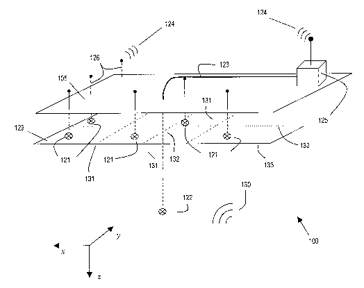
[0016] Referring to FIG. 1, in some embodiments, one or more subterranean
formations are monitored using a networlt 100 of seismic receivers. The
networlc 100
includes a plurality of seismic receivers 121 and 122, each of which are
adapted for
operation to receive seismic waves 130 generated by seismic activity and
generate
seismic trace data representing the waves 130 and indicative of the seismic
activity.
Each receiver 121, 122 may be a geophone (as shown in FIG. 1) and/or a
hydrophone
placed at a surface 105, and may be submerged in wells or on the ocean floor.
Eacli
receiver 121, 122 may be an analog or digital receiver. Other types of seismic
receivers known now or in the future may also be used. Receivers 121, 122 may
be
placed in shallow wells (for example, above the formation of interest),'deep
wells (for
example, at or below the formation of interest) or at the surface 105. The
receivers
121, 122 may be sensitive to seismic waves along a certain axis or those
traveling on
any axis. Likewise, the receivers 121, 122 may be sensitive to only certain
types of
seismic waves, or several types. Those receivers 121, 122 sensitive to a
certain axis
of travel, called directional receivers, may be coupled with other directional
receivers
121, 122. For example, multiple directional receivers 121, 122 may be coupled
together in a set of three orthogonal receivers which collect information
about the
waves 130 in three dimensions. This three-dimensional information may be
rotated
mathematically through the use of trigonometric functions in order to derive
information as to wave travel in the x-, y-, and z-axis relative to gravity.
Alternatively,
mathematical rotation may provide translation of the data relative to a
wellbore, a
cardinal direction, or any other reference point.
[0017] In one embodiment, the plurality of receivers 121, 122 includes a
plurality of
shallow well receivers 121. The plurality of receivers 121, 122 may optionally
include one or more deep well receivers 122 (only one is shown in FIG. 1). The
shallow well receivers 121 may be disposed at depths that are smaller than the
depths
at which the deep well receivers 122 are disposed. FIG. 1 shows the networlc
100 as
including a plurality of shallow well receivers 121 and a single deep well
receiver 122.
5
CA 02669555 2009-05-28
WO 2008/056267 PCT/IB2007/004318
However, any number of deep well receivers 122 or shallow well receivers 121
may
be included in the network 100.
[0018] For illustration purposes, a virtual grid 129 is depicted in FIG. 1,
and may be
generated, for example by a collection machine 125 or other processor, to
identify and
define an area of interest. Such a virtual grid 129 may be provided for any
number of
receiver locations, and may include any combination of shallow well receivers
121
and deep well receivers 122 at various depths and locations. Although the grid
129
encompasses the locations of each receiver 121 in the embodiment shown in FIG.
1,
one or more receivers 121 may be located outside of the grid 129.
[0019] In one embodiment, the receivers 121, 122 may be connected in
commLmication with the collection machine 125 by a direct connection 123, such
as a
wired connection or a fiber connection, or by a wireless connection 124. In
the
embodiment shown in FIG. 1, the deep well receiver 122 is connected to the
collection machine by a direct connection 123, such as a wired connection. The
plurality of shallow well receivers 121 is connected to the collection machine
125 via
a wireless connection 124. The wireless connection 124 may be provided for by
an
antenna 126 (and other suitable wireless equipment) for generation of a
wireless
communications signal. The illustration of FIG. 1 is non-liiniting and merely
exemplary of one embodiment of the microseismic networlc 100. For example, any
number of shallow well receivers 121 and deep well receivers 122 may be
included in
the networlc 100. Furthermore, the collection machine 125 may be connected to
the
plurality of receivers 121, 122 by any combination of connections, inchtded
direct or
wired connections and wireless connections.
[0020] The seismic waves of interest for microseismic monitoring are generally
of
very small amplitude. As small amounts of noise will affect the signal to
noise ratio
of the received signals greatly, it is advantageous to place the receivers
121, 122 in an
area where noise is minimized. In one embodiment, the receivers 121, 122
should be
placed as close to the source as possible. Such a placement maximizes the
signal to
noise ratio appreciated from the receiver. However, as the location of the
sources is
unlcnown at the onset, such a placement may not be feasible or possible.
Additionally,
the location of the sources of interest may generally be deep; placement
nearby may
be prohibitively costly, particularly for a large network. Though receivers
121,122
6
CA 02669555 2009-05-28
WO 2008/056267 PCT/IB2007/004318
may be placed at the surface 105 or undersea, one embodiment places the
receivers
beneath the weather layer. The weather layer is the geological layer Lmder
which the
effects of climatological changes (wind, rain, temperature, hLunidity, etc.)
are not
detectable.
[0021] Each receiver 121, 122 is adapted to detect seismic signals, for
exaznple in the
form of seismic or acoustic waves 130, and generate a stream of seismic trace
data
indicative of the waves 130. Trace data may include data regarding seismic
events
and data that is considered noise. Each stream of trace data includes a
plurality of
data points generated by a respective receiver 121, 122 during a selected
duration of
time or time window. The plurality of data points from a single receiver 121,
122
over the selected duration of time or time window is referred to as a"trace .
These
data points may also be referred to as a "trace data stream". In one
embodiment, each
of the plurality of data points represents an amplitude of the wave 130
received by the
receiver 121, 122 at a certain time in the time window.
[0022] The networlc 100 used to detect the seismic signals may include any
ni.unber of
receivers 121, 122, and can be quite large. In one embodiment, each receiver
location
may record data from multiple receivers. For example, multiple receivers 121,
122
may be placed in a single location so that data may be recorded from multiple
receivers 121, 122, Thus, the terms "receiver" and "receiver location" may
analogously denote a location that may generate one or more traces. In another
example, receivers 121, 122 that are sensitive to x-axis, y-axis, or z-axis
directions
may be disposed in a single location to record seismic events or activity. In
such an
example, three or more traces may be generated from each single location.
Monitoring of an entire network, which may consist of tens or hundreds of
sensing
locations, may generate a large number of traces.
[0023] In one embodiment, the plurality of receivers 121, 122, or airy subset
thereof,
are placed at substantially the same depth and/or are placed within a geology
having a
uniform velocity model. For example, as shown in FIG. 1, the shallow well
receivers
121 are all placed at substantially the same depth. However, in an alternative
embodiment, receivers 121, 122 having a variety of depths or within disparate
velocity models may be used, with the data ultimately collected being
corrected for
such features. It will be understood that, though a"receiver" may be referred
to in the
7
CA 02669555 2009-05-28
WO 2008/056267 PCT/IB2007/004318
singular, it may include one or more actual seismic sensors. For example, a
receiver
121, 122 may include three component receivers.
[0024] Tn one embodiment, the receivers 121, 122 include permanent sensors,
cemented in place in wells without casing. In alternate embodiments, however,
the
receivers 121, 122 may be placed within cased wells, placed at the surface 105
in a
temporary manner or otherwise located by other methods lmown now or in the
future.
[0025] The location of each receiver 121, 122 may be lrnown and may be
recorded in
advance. In one embodiment, the locations of each receiver 121, 122 may fonn a
grid,
such as a grid of uniformly spaced receiver locations. In a.nother embodiment,
the
locations may form a square grid, triangular grid or hexagonal grid. Any
configuration of locations may be utilized, as desired by the user and/or
based on the
environment. Accordingly, any configuration of the set of receivers 121, 122
may be
used. Information from multiple receivers 121, 122 (for example, three of the
receivers 121) may be triangulated in order to estimate the location of a
seismic event.
[0026] Each receiver 121, 122 may be equipped with transmission equipment to
communicate ultimately to the collection machine 125 or other processing
inachine.
Any of several different transmission media and methods may be used to connect
any
combination of receivers 121, 122 in communication with the collection machine
125.
Examples of such connections may include wired, fiber optic or wireless
connections.
Other examples may also include direct, indirect or networlced connections
between
the receivers 121, 122 and the collection machine 125.
[00271 Referring to FIG. 2, the plurality of receivers 121, 122 may be
connected to at
least one collector, which may be a collection machine 125 or other device or
system
adapted to receive seisniic traces from one or more of the plurality of
receivers 121,
122. In one embodiment, the collector may include one or more collection
machines
125 or other devices. The collector may be adapted to receive real-time or
near real-
time data.
[0028] The collection machine 125 may include a computer system having a
storage
medium. In one embodiment, the collection machine 125 may include, without
limitation, at least one power supply 205, an input / output bus 210, a
processor 215, a
memory device or system 220, a cloclc 225 or other time measurement device,
and
8
CA 02669555 2009-05-28
WO 2008/056267 PCT/IB2007/004318
other components (not shown) such as an input device and an output device. The
power supply 205 may be incorporated in a housing along with other components
of
the collection machine 125, or may be connected remotely such as by a wired
connection. Other components may be included as deemed suitable, such as
additional processors and/or displays for providing and/or displaying seismic
data.
[0029] FIG. 3 illustrates a method 300 for monitoring seismic events and
determining
locations of seismic events, which may be utilized in, but is not limited to,
microseismic passive monitoring. The method 300 includes one or more stages
305,
310, 315, 320, 325 and 330. The method 300 is described herein in conjunction
with
the plurality of receivers 121, 122, although the method may be perfonned in
conjunction with any number and configuration of receivers. The method 300 may
be
performed by the collection machine 125 and/or any other processor, which may
be
associated with the collection machine 125 and/or one or more of the phirality
of
receivers 121, 122.
[0030] In a first stage 305, traces are received from one or more of the
plurality of
receivers 121, 122. In one embodiment, each trace is collected by the
collection
machine 125. For example, the collection machine 125 collects traces from at
least
three receivers 121. The traces collected from the receivers may include real-
time or
near real-time data.
[0031] In one embodiment, the method 300 may be performed in response-to
receiving seismic data by the collection machine 125 or other processor. For
example,
the collection machine 125 may be adapted to automatically initiate the method
300 in
response to a triggering event. An example of a triggering event may include
the
reception of a seismic signal having a magnitude greater than a selected
threshold
inagnitude. The collection machine 125 may automatically process the seismic
data
in real-time or near real-time, such as by the method 300. The collection
machine (or
other processor) may thus provide real-time or near real-time location
information as
a seismic event is occurring.
[0032] In a second stage 310, the traces are processed, for exainple by the
collection
machine 125, for a potential event location to deterxnine if a valid potential
event
occurred at that location.
9
s: a CA 02669555 2009-05-28
WO 2008/056267 PCT/IB2007/004318
[0033] In one embodiment, a wavelet transform may be provided to validate the
potential event by recognizing an actual seismic event. A mother wavelet may
be
provided that has been extracted from a seismic signal recorded at the
receiver
location that corresponds to a known actual seismic or microseismic event.
Wavelet
processing allows the system to identify and/or classify seismic events.
[0034] Use of the wavelet transform allows for the discarding of signals that
exceed
the selected threshold magnitude, but otherwise are not indicative of seismic
events.
For example, noise generated by human surface activity or other sources may
generate signals that exceed the selected threshold magnitude and thus may
trigger the
method 300. Initiation of the method 300 solely based on the threshold may not
be
sensitive to different types of signals that exceed the threshold, as
initiation may be
triggered as soon as the signal is energetic enough. Processing to validate
the traces
(e.g., based on the wavelet transform) allows for the discarding of traces
representing
lrnown sources of noise, and thus reduces the risk of false alann.
[0035] In one embodiment, the processing may include processing data from
multiple receivers in relation to a potential event location to determine
whether the
potential location is valid. For example, if an intermediate receiver between
the
potential event location and a subject receiver did not detect an event, then
there was
no event at the potential event location. Either the event occuiTed at a
different
location or the event is the result of an error in the system.
[0036] If the potential event appears valid and for a valid location within
the field of
interest, the collection machine 125 begins a beam forming process to
automatically
locate the location of the event. The process is based upon the calculation of
an
energy level after a time-shift of the traces at one or more receivers and a
summation
of the resulting traces.
[0037] The following naming and numbering convention is provided to ilhistrate
the
method 300 described herein. The naming and number convention provided is
arbitrarily chosen, and is provided for explanation only.
[0038] "Rn" corresponds to a specific receiver number in the plurality of
receivers, at
a given location at the surface or downhole in a wellbore, such as wellbore
125. For
example, each of the receivers 121 may correspond to Rl, R2, R3 ... Rn,
respectively.
~ .;
CA 02669555 2009-05-28
WO 2008/056267 PCT/IB2007/004318
"Trace,,,(t)" corresponds to each of a plurality of data points in a specific
trace in a
specific time window. "Ep,.,(t)" corresponds to a trace generated by a
receiver having
a corresponding receiver number, which may be computed from multiple traces
(tracem(t)). In one embodiment, tracen,(t) and ER,,(t) represent the amplitude
or energy
level of a waveform for each of the plurality of data points in the tiune
window.
`Fp,,(t)" corresponds to a time-shifted trace. "NodeX" corresponds to each of
the
ph.irality of nodes, such as nodes 131. "E,(t) corresponds to a node trace,
and "E,"
corresponds to a node energy value for each node,
[0039] In a third stage 315, an area of interest is defined, which may include
an area
around one or more of the plurality of receivers 121 that detected the event.
The area
of interest is divided into an array of nodes. Each node may represent a
probability
location, i.e., a probability that a seismic event has occurred at the
location of the
node. In one embodiment, as shown in FIG. 1, the area of interest is defined
by the
grid 129. The grid 129 may be bounded by boundary lines 133 and further
divided by
grid lines 132. In this embodiment, nodes 131 are formed by the intersections
between the boundary lines 133, intersections between the grid lines 132,
and/or
intersections between the grid lines 132 and the boundary lines 133.
[0040] In a fourth stage 320, a travel time from each receiver 121 to the
node,t is
computed with reference to the geologic model. Calculation of travel time may,
for
example, be computed using a pre-determined signal velocity based on a
geologic
model and distances between the node, and each receiver 121.
[0041] In one embodiment, calculation of travel time asstunes a uniform
geologic
model, but does not require such uniformity. If the geologic model is non-
uniform,
the non-uniformity may be taken into account as the different geologic models
are
computed in the travel time calculation. In another embodiment, the receivers
121 are
initially placed in a configuration that permits iuli.form geologic model
treatment.
Similarly, the receivers 121 may be initially placed in a configuration that
may
improve or optimize the method 300 by taking into account the non-uniformity
of the
model. Such a placement may be provided, for example, in order to obtain a
similar
waveform on the different receivers 121 for a particular target zone and/or in
order to
improve the location accuracy.
11
CA 02669555 2009-05-28
WO 2008/056267 PCT/IB2007/004318
[0042] In a fifth stage 325, each of the traces for the receivers 121 is
adjusted for each
of the array of nodes according to the travel time. In one embodiment, each of
the
traces (tracem(t)) or (Ep,,(t)) for the receivers 121 used in conjunction with
the nodeX
location is time-shifted to match the travel time to the node,t. A time-
shifted trace
(Fp,,(t)) may be calculated for each receiver 121.
[0043] The traces (tracem(t)) may be processed to produce a single trace
(ER,,(t)) for a
location of each receiver 121. In the event that a receiver location includes
multiple
receivers or sensors, the traces (trace,n(t)) from each receiver or sensor may
be.
summed together to form the single resultant trace (Ep.,(t)). The trace
(trace,,,(t)) may
be a single trace or multiple traces from a single receiver location. In one
embodiment, for a receiver location that generates only one trace, the trace
(tracem(t))
may be equivalent to the resultant trace (ERõ(t)).
[0044] For example, the trace (tracem(t)) may either be the trace of one
particular axis
of the receiver or traces corresponding to multiple axes, such as orthogonal
x, y and z
axes. In one embodiment, three-dimensional information from a respective
receiver
121 may be mathematically rotated in tlie direction of the nodeX and the trace
(tracen,(t)) corresponding to the longitudinal direction between the
respective receiver
and the nodex may be selected as the "trace" for the respective receiver.
[0045] In one embodiment, the resultant trace (ERõ(t)) may be calculated using
the
following equation (Equation 1):
(1) ER,(t) = sqrt [tracei(t)2 + . . . traceri,(t)z].
[0046] In this embodiment, the resultant trace (ERõ(t)) for each receiver 121
is
calculated by calculating a square root of the sum of the square of each
tracen,(t)
received for a respective receiver 121 in a selected time window.
[0047] In one example, the resultant trace (ERõ(t)) is calculated from the
traces
(trace,,,(t)) generated by a multi-dimensional receiver, such as a receiver
121 that
generates traces in three orthogonal dimensions x, y and z. These traces may
be
represented as trace,,(t), tracey(t) and traceZ(t). Calculation of the
resultant trace
(ER~,(t)) may be represented by the equation (Equation 2):
12
CA 02669555 2009-05-28
WO 2008/056267 PCT/IB2007/004318
(2) ER,(t) = sqrt [traceX(t)Z + tracey(t)Z + traceZ(t)z].
[0048] In this equation, trace,,(t) is the trace of a first horizontal axis,
tracey(t) is the
trace of a second horizontal axis, and traceZ(t) is the trace of a vertical
axis.
[0049] ln one embodiment, each tracen,(t) and/or resultant trace (E.Rõ(t)) may
be
calculated using methods that include statistical analysis, data fitting, -and
data
modeling. Examples of statistical analysis include calculation of a summation,
an
average, a variailce, a standard deviation, t-distribution, a confidence
interval, and
others. Examples of data fitting include various regression methods, such as
linear
regression, least squares, segmented regression, hierarchal linear modeling,
and others.
Examples of data modeling include direct seismic modeling, indirect seismic
modeling, and otliers.
[0050] In one embodiment, the time-shifted traces (FR,(t)) from the receivers
121 are
sumuYed or staclced to determ.ine a node trace (EX(t)) corresponding to the
nodex.
[0051] The node trace (EX(t)) may be calculated from any number of time-
shifted
traces (FR,,(t)). Such a calculation may be represented by the equation
(Equation 3):
(3) E,
.,(t) = [FR1(t) + . . . Fxõ(t)]
[0052] This equation represents a sum of the time-shifted traces (FRõ(t)) from
a
plurality of receivers (Rn). The plurality includes a first time-shifted trace
from a first
receiver, represented by "FRI (t)", and additional time-shifted trace(s) from
any
number of additional receivers, represented by "FRn(t)' . The number of
additional
time-shifted traces (FR,,(t)) is potentially infinite and limited only by the
ability to
process and present reliable data. In one embodiment, only the traces which
have
been selected by the wavelet process as really containing a signal related to
a seismic
event are used for the calculation of the node trace.
[0053] A node energy level (E,t) for nodeX may then be calculated from the
time-
shifted traces (ERn(t)). In one embodiment, the node energy level(E,,) is
calculated
based on the node trace (E,,(t)) and/or the time-shifted traces (FRõ(t)).
[0054] The node energy level (EX) may be calculated, for example, by
normalizing the
values of the time-shifted traces (FR,,(t)) to achieve a scale value, such as
a scale value
13
CA 02669555 2009-05-28
WO 2008/056267 PCT/IB2007/004318
having a maximum of one (1). Normalization may be achieved by a method
including, for example, division of the time-shifted traces (FR,(t)) by the
standard
deviation.
[0055] In one embodiment, the node energy level (E,t) may be calculated using
the
equation (Equation 4):
(4) (E,) = f E,(t)Z dt
[0056] In this equation, the boundary of the integral corresponds to the
boundaries of
a selected time window. This equation may represent an energy level
corresponding
to the node,,.
[0057] In another embodiment, the node energy level (EX) may be calculated
using
the equation (Equation 5):
(5) (E,) = (1/N) ~ f EX(t)z dt / [ f FRl(t)Z dt + . . . f FRõ(t)Z dt]
[0058] In this equation, N represents the number of receivers 121 or receiver
locations used with the respective node,t. The boundary of the integrals in
this
equation correspond to the boundaries of a selected time window.
[0059] The above Equations 4 and 5 yield equivalent values in terms of
probability,
however the value yielded by Equation 5 is normalized and may have a value
between
zero (0) and one (1). Higher values, including values that are close to and
approaching one (1), may indicate seismically active zones (e.g., zones that
emit a lot
of noise) and/or seismic events and may be an indicator of the consistency of
the
signal on the different receivers 121 used for calculating the node trace
E,,(t). In one
embodiment, these values can be related to a quality parameter (or confidence
parameter) of the location.
[0060] The method for calculating the node energy level (E") is not limited.
The node
energy level (E,) may be calculated by detenn.ining the energy level of the
stacked
node trace (EX(t)) by any other suitable methods lcnown now or in the future.
14
CA 02669555 2009-05-28
WO 2008/056267 PCT/IB2007/004318
[0061] Stages 320 and 325 define an iterative process that is undertaken for
each node.
Thus, stages 320 and 325 are repeated for each node, so that each node may be
assigned an energy level(EX).
[0062] In a sixth stage 330, the node energy levels (E,,) are compared, and
the node
witli the greatest node energy level (EX) is estimated to be the location of
the event. In
one embodiment, in the case that the event actually occurs outside of the
field of
interest, the greatest node energy level (Ex) may be located on the edge of
the field' of
interest. In such a case, the result (i.e., the greatest node energy level
(EX)) is tested to
see if the estimated location, i.e., node;, having the greatest energy level
(E,), is on the
edge of the field of interest. If so, the result is discarded and a different
field of
interest may be selected in order to properly estimate the location of the
event.
[0063] Referring to FIG. 4, in one embodiment, the results of the node energy
level
(E,) computation for each nodeX may be plotted on a graph at a representative
location
relative to the receivers 121. Values of Ex may be represented by varying
shades
and/or colors. For example, FIG. 4 shows a plot 400 of E,, values for a
plurality of
nodes, in relation to the receivers 121. In the current example, greater
values of E,
are shown as darker areas in an area of interest 405. In another example,
greater
values of E. may be represented by one color (red, for example), with lesser
values
represented by another color (blue, for example). In this way the results of
the
automatic location may be quiclcly appreciated by the system user. The
location of
the receivers 121 may be represented on the plot 400 (in the current example,
by a
circle), as well as the location 410 of greatest energy (in the ciurent
example, by a
star).
[0064] The result of the automatic location process may then additionally be
plotted
on a wider map 500 of the field being monitored, as shown for example in FIG.
5.
The locations of receivers 121 used in the method described herein (and shown
in
FIG. 4) are provided, in addition to the locations of additional receivers 521
on the
map 500.
[0065] In one embodiment, the system assumes a fixed depth for all receivers.
For
example, all of the receivers in the networlc 100 are shallow well receivers
121.
However, non-fixed depth networks of receivers may be used, and the depth may
be
CA 02669555 2009-05-28
WO 2008/056267 PCT/IB2007/004318
corrected according to known means. Accordingly, a deep well receiver 122 is
depicted to also illustrate aspects of other networlts 100.
[0066] In one embodiment, if at least three receiver locations are used in the
method
described herein, the location of the event may be computed within two
dimensions.
If at least four receiver locations are used and a three-dimensional area of
interest is
selected, the location of the event may be estimated in three dimensions.
[0067] In one embodiment, the method described herein is performed in real-
time or
near real-time, so as to immediately (for example, within approximately 60
seconds)
provide infornnation as to the location of events. "Real-time" data may refer
to data
transmitted to the collection machine upon or shortly after detection and/or
recordation by one or more receivers 121, 122. In this embodiment, the results
may
be achieved quickly enough to modify a frac process, remove personnel from a
dangerous area, or allow other interventions in time to save life, limb and
property.
[0068] In one embodiment, the location identified by the foregoing method is
considered the most probable point at which an event has occurred. In one
embodiment, the second-most-probable and other less likely locations are also
recorded, along with their energy strengths. The results of several automatic
location
processes may then be summed in order to select a location having an improved
probability of being the location of the event. In another einbodiunent, the
less-lilcely
locations are simply reported to the user as secondarily probable locations of
the event.
[0069] Additionally, at least one program storage device readable by a
machine,
tangibly embodying at least one program of instructions executable by the
machine to
perform the method 300 may be provided. In one embodiment, the method 300 is
performed by a processor or other processing machine such as collection
machine 125.
[0070] The systems and methods described herein provide various advantages
over
existing seismic monitoring systems. The systems and methods described herein
allow for accurate determination of seismic event locations, and also provide
seismic
event location information in a very timely manner, so that interventions may
be
undertaken immediately as suggested by the events.
16
CA 02669555 2009-05-28
WO 2008/056267 PCT/IB2007/004318
[0071] In support of the teachings herein, various analysis components may be
used,
including digital and/or analog systems. The devices, systems and methods
described
herein may be implemented in software, firmware, hardware or any combination
thereof. The devices may have components such as a processor, storage media,
memory, input, output, communications linlc (wired, wireless, pulsed mud,
optical or
other), user interfaces, software programs, signal processors (digital or
analog) and
other such components (such as resistors, capacitors, inductors and others) to
provide
for operation and analyses of the devices and methods disclosed herein in any
of
several manners well-appreciated in the art. It is considered that these
teachings may
be, but need not be, implemented in conjunction with a set of computer
executable
instructions stored on a computer readable medium, including memory (ROMs,
RAMs), optical (CD-ROMs), or magnetic (disks, hard drives), or any other type
that
when executed causes a computer to implement the method of the present
invention.
These instructions may provide for equipment operation, control, data
collection and
analysis and other functions deemed relevant by a system designer, owner, user
or
other such personnel, in addition to the functions described in this
disclosure. The
computer executable instructions may be included as part of a computer system
or
provided separately.
[0072] Further, various other components may be included and called upon for
providing for aspects of the teachings herein. For example, a pump, piston,
power
supply (e.g., at least one of a generator, a remote supply and a battery),
motive force
(such as a translational force, propulsional force or a rotational force),
magnet,
electromagnet, sensor, electrode, transmitter, receiver, transceiver, antenna,
controller,
optical unit, electrical unit or electromechanical unit may be included in
support of the
various aspects discussed herein or in support of other functions beyond this
disclosure.
[0073] One slcilled in the art will recognize that the various components or
technologies may provide certain necessary or beneficial fiutictionality or
features.
Accordingly, these functions and features as may be needed in support of the
appended claims and variations thereof, are recognized as being inherently
included
as a part of the teachings herein and a part of the invention disclosed.
17
CA 02669555 2009-05-28
WO 2008/056267 PCT/IB2007/004318
[0074] While the invention has been described with reference to exemplary
embodiments, it will be understood that various changes may be made and
equivalents may be substituted for elements thereof without departing from the
scope
of the invention. In addition, many modifications will be appreciated by those
skilled
in the art to adapt a particular instrument, situation or material to the
teachings of the
invention without departing from the essential scope thereof. Therefore, it is
intended
that the invention not be limited to the particular embodiment disclosed as
the best
mode contemplated for carrying out this invention, but that the invention will
include
all embodiments falling within the scope of the appended claims.
18