Note : Les descriptions sont présentées dans la langue officielle dans laquelle elles ont été soumises.
CA 02673474 2009-06-19
WO 2008/127612 PCT/US2008/004623
SYSTEM AND METHOD FOR MARINE SEISMIC SURVEYING
CROSS-REFERENCES TO RELATED APPLICATIONS Not Applicable
FEDERALLY SPONSORED RESEARCH OR DEVELOPMENT Not Applicable
SEQUENCE LISTING, TABLE, OR COMPUTER LISTING Not Applicable
BACKGROUND OF THE INVENTION
1. Field of the Invention
[0001] This invention relates generally to the field of geophysical
prospecting and
particularly to the field of marine seismic surveying.
2. Description of the Related Art
[0002] In the oil and gas industry, geophysical prospecting is commonly
used to aid in
the search for and evaluation of subterranean formations. Geophysical
prospecting
techniques yield knowledge of the subsurface structure of the earth, which is
useful for
finding and extracting valuable mineral resources, particularly hydrocarbon
deposits such as
oil and natural gas. A well-known technique of geophysical prospecting is a
seismic survey.
In a land-based seismic survey, a seismic signal is generated on or near the
earth's surface
and then travels downwardly into the subsurface of the earth. In a marine
seismic survey, the
seismic signal may also travel downwardly through a body of water overlying
the subsurface
of the earth. Seismic energy sources are used to generate the seismic signal
which, after
propagating into the earth, is at least partially reflected by subsurface
seismic reflectors.
Such seismic reflectors typically are interfaces between subterranean
formations having
different elastic properties, specifically wave velocity and rock density,
which lead to
differences in elastic impedance at the interfaces. The reflections are
detected by seismic
sensors at or near the surface of the earth, in an overlying body of water, or
at known depths
in boreholes. The resulting seismic data are recorded and processed to yield
information
1
CA 02673474 2009-06-19
WO 2008/127612 PCT/US2008/004623
relating to the geologic structure and properties of the subterranean
formations and their
potential hydrocarbon content.
[0003] Appropriate energy sources may include explosives or vibrators on
land and air
guns or marine vibrators in water. Appropriate types of seismic sensors may
include particle
velocity sensors in land surveys and water pressure sensors in marine surveys.
Particle
velocity sensors are commonly know in the art as geophones and water pressure
sensors are
commonly know in the art as hydrophones. Both seismic sources and seismic
sensors may be
deployed by themselves or, more commonly, in arrays.
[0004] In a typical marine seismic survey, a seismic survey vessel travels
on the water
surface, typically at about 5 knots, and contains seismic acquisition
equipment, such as
navigation control, seismic source control and seismic sensor control
equipment, and
recording equipment. The seismic source control equipment causes a seismic
source towed
in the body of water by the seismic vessel to actuate at selected times.
Seismic streamers,
also called seismic cables, are elongate cable-like structures that are towed
by the seismic
survey vessel that tows the seismic source or by another seismic survey ship.
Typically, a
plurality of seismic streamers is towed behind a seismic vessel. The seismic
streamers
contain sensors to detect the reflected wavefields initiated by the seismic
source and reflected
from reflecting interfaces. Conventionally, the seismic streamers contain
pressure sensors
such as hydrophones, but seismic streamers have been proposed that contain
water particle
motion sensors such as geophones, in addition to hydrophones. The pressure
sensors and
particle velocity sensors may be deployed in close proximity, collocated in
pairs or pairs of
arrays along a seismic cable.
[0005] The pressure and particle motion sensors detect waves traveling
upward in the
water after reflection from the interfaces between subterranean formations.
These waves,
known as primary waves, contain the sought after information about the
structure of the
subterranean formations. The sensors also detect waves traveling downward in
the water
after reflection from the air-water interface at the water surface. These
waves are known
generally as secondary waves or "ghosts".
[0006] Both pressure and particle motion waves experience a reversal in
polarity at the
air-water interface. Thus, pressure sensors, which are omni-directional and
hence do not
distinguish directions, detect the reversal of phase polarity in ghost waves.
However, vertical
particle motion sensors, which are directional, do not detect a phase
reversal, since the up-and
down-going wavefield also have an opposite polarity due to a change in
direction and this
cancels the polarity change due to reflection at the water-air interface. This
polarity
2
CA 02673474 2015-05-19
difference in sensor detection of ghosts, between pressure and particle motion
sensors, can be
employed to substantially cancel the ghosts. Therefore, the proper combination
of the
pressure and particle motion sensor signals can be utilized to deghost marine
seismic data.
[0007] However, particle motion sensors, such as geophones and
accelerometers, are
much more susceptible to picking up unwanted noise from mechanical vibrations
in the
towed streamers than pressure sensors, such as hydrophones. Thus, the simple
combination of
particle motion and pressure sensor signals result in a low signal-to-noise
ratio because of the
extra noise in the particle motion sensor. This mechanical streamer noise is
typically more
evident in the lower frequencies, below 50 Hz.
[0008] Various solutions to the noise problem have been proposed. For
example, Albert
Berni, in his U.S. Patent No. 4,437,175, "Marine Seismic System", issued Mar.
13, 1984,
describes a system comprising a hydrophone and an integrated accelerometer in
a marine
seismic streamer. This patent proposes filtering the particle velocity signal
from the
integrated accelerometer to attenuate lower frequencies before combining with
the pressure
signal from a hydrophone for further processing. However, there has not been
any
commercial implementation of a streamer cable that utilizes both particle
motion and pressure
sensor.
[0009] Thus, a need exists for a system for marine seismic surveying that
includes a
particle motion sensor, such as a geophone, that is less susceptible to low
frequency noise.
Such a sensor would be useful for employment in conjunction with pressure
sensors, such as
hydrophones, in marine seismic streamers for attenuating mechanical streamer
noise to
improve signal-to-noise ratio.
BRIEF SUMMARY OF THE INVENTION
[0009.1] In one aspect of the invention there is provided a system for
marine seismic
surveying, comprising:
(a) a pressure sensor and a particle motion sensor collocated on a marine
seismic
streamer and configured to output pressure and particle motion signals,
respectively, in
response to receiving seismic reflections, wherein the particle motion sensor
has a resonance
frequency above 20 Hz; and
(b) a computer system configured to process digitized versions of the pressure
and
particle motion signals.
3
CA 02673474 2015-05-19
[0009.2] In a further aspect of the invention there is provided a method
for marine
seismic surveying, comprising:
a) towing at least one marine seismic streamer;
b) acquiring a pressure signal from at least one pressure sensor mounted in
the at
least one marine seismic streamer;
c) acquiring a particle motion signal from at least one particle motion sensor
mounted in the at least one marine seismic streamer and collocated with the at
least one pressure sensor,
d) wherein the at least one particle motion sensor has a resonance frequency
above 20 Hz; and
e) processing, at a computer system, digitized versions of the pressure and
particle motion signals.
[0010] In one embodiment, the invention is a system for marine seismic
surveying,
comprising: at least one marine seismic streamer; at least one pressure sensor
mounted in the
at least one marine seismic streamer; at least one particle motion sensor
mounted in the at
least one marine seismic streamer and collocated with the at least one
pressure sensor,
wherein the at least one particle motion sensor has a resonance frequency
above 20 Hz; and
computer means for combining pressure data from the at least one pressure
sensor and
particle motion data from the at least one particle motion sensor for further
processing.
[0011] In another embodiment, the invention is a method for marine seismic
surveying,
comprising: towing at least one marine seismic streamer; acquiring pressure
data from at least
one pressure sensor mounted in the at least one marine seismic streamer;
acquiring particle
motion data from at least one particle motion sensor mounted in the at least
one marine
seismic streamer and collocated with the at least one pressure sensor, wherein
the at least one
particle motion sensor has a resonance frequency above 20 Hz; and combining
the pressure
data and the particle motion data for further processing.
BRIEF DESCRIPTION OF THE DRAWINGS
[0012] The invention and its advantages may be more easily understood by
reference to the
following detailed description and the attached drawings, in which:
[0013] FIG. 1 is a graph of frequency response of a geophone according to the
present
invention;
[0014] FIG. 2 is a graph of frequency response of a standard geophone;
4
CA 02673474 2015-05-19
[0015] FIG. 3 is a graph of frequency response for an accelerometer and three
geophones
according to the present invention; and
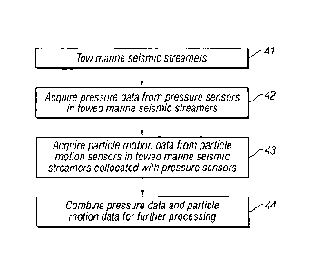
[0016] FIG. 4 is a flowchart illustrating the steps of an embodiment of the
method of the
invention for marine seismic surveying.
[0016.1] FIG. 5 is a schematic illustration of an embodiment of a system for
marine seismic
surveying.
[0017] While the invention will be described in connection with its preferred
embodiments, it
will be understood that the invention is not limited to these. On the
contrary, the invention is
intended to cover all alternatives, modifications, and equivalents that may be
included within
the scope of the invention, as defined by the appended claims.
DETAILED DESCRIPTION OF THE INVENTION
[0018] In one embodiment, the invention is a system for marine seismic
surveying. The
system according to the invention comprises towed marine seismic streamers
with pressure
sensors and particle motion sensors mounted collocated within the streamer.
The pressure
sensors are preferably hydrophones and the particle motion sensors are
preferably geophones.
The particle motion sensors are designed to have a resonance frequency above
20 Hz.
[0019] The system of the invention may be employed to record pressure data and
particle
motion data with the pressure and particle motion sensors, respectively. Then,
the pressure
data and the particle motion data may be combined, by conventional computer
means, as is
well known in the art of seismic data processing. Such computer means would
include, but
would not be restricted to, any appropriate combination or network of computer
processing
4a
CA 02673474 2009-06-19
WO 2008/127612 PCT/US2008/004623
elements including, but not limited to, hardware (processors of any type,
temporary and
permanent memory, and any other appropriate computer processing equipment),
software
(operating systems, application programs, mathematics program libraries, and
any other
appropriate software), connections (electrical, optical, wireless, or
otherwise), and peripherals
(input and output devices such as keyboards, pointing devices, and scanners,
display devices
such as monitors and printers, storage media such as disks and hard drives,
and any other
appropriate equipment).
[0020] Geophones are typically electromagnetic devices comprising at least
two
interacting elements, a coil and a magnet. The coil and the magnet are
included within a
geophone casing, which is, in turn, connected to the medium through which the
seismic
signals travel. One of the two elements, either the coil or the magnet, is
rigidly affixed to the
casing, while the other element is flexibly suspended from the casing. The
fixed element
then moves with the geophone casing, while the suspended element acts as an
inertial mass.
Thus, as the medium moves in response to the seismic signal transmitted
through it, the fixed
element moves integrally with the geophone casing and the medium. The
suspended element
tends to remain stationary while the casing moves up and down in response to
passing
seismic waves.
[0021] This relative axial movement between the coil and magnet induces an
electrical
current in the coil as the coil windings cut the lines of magnetic flux from
the magnet. The
electric current generated in the electric coil is proportional to the rate of
change of flux
through the coil and forms the geophone output signal, with the voltage being
proportional to
the velocity of the motion of the fixed element. Typically, the magnet moves
with the
geophone casing, while the coil acts as the inertial mass. The coil is
typically a solenoid coil,
an annular winding of electrical wire, and the magnet is typically a permanent
magnet. The
coil is suspended from the geophone casing by a spring system.
[0022] The combination of the suspended element and the spring system has a
resonance,
or natural, frequency which depends upon the inertial mass and the restoring
force of the
spring suspension. In a standard electromagnetic geophone, the resonance
frequency J.
depends upon the mass m of the suspended inertial element, whether coil or
magnet, and the
stiffness coefficient k of the spring as follows:
1 IT
(1)
27z- m
CA 02673474 2009-06-19
WO 2008/127612 PCT/US2008/004623
The spring constant k is the proportionality constant between force acting on
the spring and
elongation of the spring attributable to that force. The combination of the
suspended element
and the spring system can be designed so that the spring constant k and
inertial mass m give a
predetermined resonance frequency J. Conventionally, geophones with a
resonance
frequency./ around 10 Hz has been utilized. In the system of the invention,
geophones with a
resonance frequency fr above 20 Hz are employed. Thus, the spring constant k
and the
suspended inertial mass m of the geophone of the invention are selected such
that the
combination yields a resonance frequency/ above 20 Hz.
[0023] Additionally, damping of the suspended element is usually introduced
to equalize
the geophone's response across the frequencies above the resonance frequency.
The damping
may be obtained by including it as part of the suspension system by, for
example, employing
a damping resistor acting as a shunt across the electric coil or by immersing
the suspended
element in a viscous liquid. The damping is usually expressed as a damping
coefficient,
representing a fraction of the critical damping R, given by:
= 2../Tm ,
(2)
which represents the maximum amount of damping that will just eliminate the
oscillatory
response of the geophone. A damping coefficient in the range of approximately
0.5 to 0.7 is
typically employed. In all of the following examples, a damping coefficient of
0.6 is utilized.
[0024] When the frequency of the driving motion from the seismic signal is
above the
resonance frequency of the geophone, the displacement of the casing, relative
to the inertial
mass, is equal to and can be utilized as a direct measure of the driving
motion, i.e., the
seismic signal. Below the resonance frequency, the sensitivity of the geophone
falls off at a
rate of about -12 dB per octave. Thus, in the system of the invention, the
geophones
employed have a lower response to the signal and to noise at frequencies below
the resonant
frequency, and especially in the range of 1-10 Hz, than in the higher
frequencies. The lower
frequencies are just where noise from mechanical streamer vibration resides.
Thus,
geophones as employed in the invention will detect and record less of this
mechanical noise
than conventional geophones used in seismic exploration.
[0025] FIG. 1 shows the frequency response of a geophone which could be
employed in
the system of the invention. FIG. 1 shows the frequency response 11 of a
geophone
according to the present invention as a graph of sensitivity in dB versus
frequency in Hz.
6
CA 02673474 2009-06-19
WO 2008/127612 PCT/US2008/004623
This particular geophone in the example has a resonance frequency of 40 Hz,
which is above
20 Hz, as specified in the invention. However, geophones with other resonance
frequencies,
such as will be discussed below in reference to FIG. 3, could also be employed
in the system
of the invention.
[0026] For comparison, consider the response of a standard seismic geophone
having a
resonance frequency of 10 Hz. FIG. 2 shows the frequency response 21 of this
standard
geophone as a graph of sensitivity in dB versus frequency in Hz. For this
standard geophone,
there could be, for example, noise in the frequency response (indicated at
numeral 21) at 10
Hz (indicated at numeral 22) that is 60 dB stronger that the measured signal
from 50-100 Hz
(indicated at numeral 23). Harmonic distortion can also be anticipated at
multiples of the
noise frequencies. Because of this harmonic distortion, the dynamic range of
the digitized
output signal and the quality of the signal of interest will be limited.
[0027] The frequency response 11 of the geophone according to the
invention, shown in
FIG. 1, is reduced in the range of 1-10 Hz (indicated at numeral 12) by 20-
68dB, which will
have a beneficial effect on available dynamic range and harmonic distortion,
as compared to
a standard geophone. The slope of the frequency response 11 on the low
frequency
(indicated at numeral 12) end is normally about ¨12 dB per octave for a
geophone as in the
invention.
[0028] As discussed above, the geophone of the invention is designed
through
appropriate selection of the spring constant k and the suspended inertial mass
m so that the
combination yields a resonance frequency f. above 20 Hz. In particular
embodiments, the
resonance frequency is selected in the range of 30 to 50 Hz. FIG. 3 shows the
frequency
responses of three geophones according to the present invention with
representative
resonance frequencies of 30, 40, and 50 Hz. The graphs of frequency response,
indicated by
numerals 32, 33, and 34, correspond to resonance frequencies of 30, 40, and 50
Hz,
respectively. The geophone with a resonance frequency of 40 Hz (indicated by
numeral 33),
is the same as shown in FIG. 1.
[0029] In a geophone having a resonant frequency of 10 Hz, the detected low
frequency
noise will have an amplitude that is much higher than the amplitude of the
detected seismic
signal. If the full dynamic range of the detected signal plus noise of a 10 Hz
geophone is
digitized, the analog to digital converter (typically with 24 bit resolution)
will be
overwhelmed with the low frequency noise, with the actual seismic signal then
having a
lower resolution (and less precision) than would be the case if the noise were
not present in
the seismic signal. A further advantage is that a geophone with a resonant
frequency of 20
7
CA 02673474 2015-05-19
Hz or higher will have a more linear output, because it is not creating
harmonics of the low
frequency noise. For example, 10 Hz noise will create big 2nd, 3rd, and 4th
harmonics at 20
= Hz, 30 Hz and 40 Hz. For these reasons, it is highly advantageous to
utilize a geophone with
a higher resonant frequency, which acts as an analog filter to attenuate the
strong noise at low
frequencies before the seismic signal is digitized.
[0030] Any signal detected by a geophone in a marine seismic
streamer in the frequency
range below about 20 Hz can be expected to be primarily noise, and for that
reason the
geophone signal is typically filtered to eliminate frequencies below about 20
Hz before the
geophone signal is combined with the hydrophone signal as further described
herein. The
geophone phase and frequency response will typically be matched to that of the
hydrophone
signal before combination with the hydrophone signal for deghosting.
[0031] In one embodiment, the particle motion sensor of the
present invention is utilized
in a method for combining signals of a pressure sensor and a particle motion
sensor recorded
in a marine seismic streamer, as described in U.S. Patent Application
Publication No. US
2005/0195686 Al, of Svein Vaage et al., "System for Combining Signals of
Pressure Sensors
and Particle Motion Sensors in Marine Seismic Streamers", published Sep. 8,
2005. In this
embodiment, the recorded pressure sensor signal has a bandwidth comprising a
lower
frequency range and a higher frequency range, with the recorded signal of the
particle motion
sensor of the invention having a bandwidth comprising at least the higher
frequency range. A
particle motion sensor signal is calculated in the lower frequency range from
the recorded
pressure sensor signal, thereby generating a simulated particle motion sensor
signal in the
lower frequency range. The simulated particle motion sensor signal is merged
in the lower
frequency range with the recorded particle motion sensor signal in the higher
frequency range
to generate a merged particle motion sensor signal having substantially the
same bandwidth
as the bandwidth of the recorded pressure sensor signal. The recorded pressure
sensor signal
and the merged particle motion sensor signal are combined for further
processing.
[0032] An accelerometer can also be used in the invention as
the particle motion sensor
instead of a geophone. FIG. 3 shows the frequency response 31 of an
accelerometer
according to the present invention as a graph of sensitivity in dB versus
frequency in I-1z. If
the same sensitivity as with the geophones is desired at 50 Hz, the
attenuation at low
frequencies will be as in FIG. 3. The slope of the frequency response 31 for
the
accelerometer, when plotted in velocity, shows an attenuation of 6 dB per
octave at low
8
CA 02673474 2015-05-19
frequencies. This means that an attenuation of 15-34 dB is obtained for
frequencies in the
range of 1-10 Hz. Thus, employing an accelerometer could also be a possible
solution to the
problem of attenuating noise in the particle motion sensor at low frequencies,
but the
accelerometer will not attenuate noise as well as the geophones will.
[0033] In a
further embodiment, the particle motion sensor of the present invention is
mounted in a marine seismic streamer in the manner described in U.S. Patent
Application
Publication No. 2005/0194201 Al, by Rune Tenghamn and Andre Stenzel, "Particle
Motion
Sensor for Marine Seismic Sensor Streamers", published Sep. 8, 2005. In this
embodiment, a
marine seismic sensor system includes a sensor jacket adapted to be towed by a
seismic
vessel through a body of water. A plurality of particle motion sensors,
according to the
present invention, are suspended within the sensor jacket at spaced apart
locations along the
jacket. Each of the particle motion sensors is suspended in the jacket by at
least one biasing
device. The mass of each particle motion sensor and a force rate of each
biasing device are
selected such that a resonant frequency of the suspension of each sensor
within the sensor
jacket is within a selected frequency range. The reduction in mechanical
streamer noise from
employing the suspension mounting means for the particle motion sensor in this
reference
compliments and augments the reduction in noise from employing the particle
motion sensor
of the present invention.
[0034] This
beneficial response of the particle motion sensors of the invention provides
for a higher signal-to-noise ratio in the recorded particle motion data and
hence, in the
combined pressure and particle motion data. This improved signal resolution
will be
advantageous in any further data processing in which the combined pressure and
particle
motion data are utilized. For example, the pressure data and the particle
motion data may be
combined to generate separate up-going and down-going wavefield components,
which may
then be processed further, as is well known in the art of seismic data
processing. For
example, the up-going wavefield component may be utilized to provide deghosted
seismic
data and to attenuate other unwanted multiple wavefields in the recorded
seismic data.
[0035] In
another embodiment, the invention is a method for marine seismic surveying.
FIG. 4 shows a flowchart illustrating the steps of an embodiment of the method
of the
invention for marine seismic surveying.
[0036] In step
41, at least one marine seismic streamer is towed in a marine environment.
Typically, many marine seismic streamers would be towed during a marine
seismic survey.
[0037] In step 42, pressure data are acquired from at least one pressure
sensor mounted in
9
CA 02673474 2015-05-19
the at least one marine seismic streamer towed in step 41. Typically, many
pressure sensors
would be mounted within the many marine seismic streamers during a marine
seismic survey.
The pressure sensors may be mounted singly or in groups. The pressure sensors
would
typically comprise hydrophones.
[0038] In step 43, particle motion data are acquired from at least one
particle motion sensor
mounted in the at least one marine seismic streamer towed in step 41 and
collocated with the
at least one pressure sensor in step 42. The particle motion sensor is
designed according to
the present invention so that it has a resonance frequency above 20 Hz.
Typically, many
particle motion sensors would be mounted within the many marine seismic
streamers and
collocated with many pressure sensors during a marine seismic survey. The
particle motion
sensors may be mounted singly or in groups. The particle motion sensors would
typically
comprise geophones. In particular, a spring constant and a suspended inertial
mass of the
geophone are selected so that the combination yields the resonance frequency
above 20 Hz.
In an alternative embodiment, the particle motion sensors could comprise
accelerometers.
[0039] In step 44, the pressure data acquired in step 42 and the particle
motion data acquired
in step 43 are combined for further processing, as is well known in the art of
seismic data
processing. For example, the pressure and particle motion data may be combined
so as to
generate deghosted marine seismic data. Techniques for combining pressure data
and particle
motion data to generate deghosted marine seismic data are well known in the
art of marine
seismic data processing.
[0039.1] FIG. 5 shows a schematic illustration of one embodiment according to
this
disclosure. As shown, survey vessel 54 tows streamer 51 in a body of water.
Various devices
may also be included in or on streamer 51. For example, sensor pairs 53 may
each include a
collocated pressure sensor and particle motion sensor. Devices 52 may be any
suitable
devices. For example (and without limitation), each device 52 could include
any of the
following: individual sensors (e.g., pressure sensors, or particle motion
sensors, or other types
of sensors); collocated pairs of sensors (such as sensor pairs 53); arrays of
sensors; or any
other suitable type of device.
[0040] It should be understood that the preceding is merely a detailed
description of specific
embodiments of this invention and that numerous changes, modifications, and
alternatives to
the disclosed embodiments can be made in accordance with the disclosure here
without
departing from the scope of the invention. The preceding description,
therefore, is not meant
to limit the scope of the invention. Rather, the scope of the invention is to
be determined only
by the appended claims and their equivalents.