Note : Les descriptions sont présentées dans la langue officielle dans laquelle elles ont été soumises.
CA 02686699 2009-11-30
SELECTING AND ANNOTATING WELL LOGS
FIELD
[0001] The present description relates to the field of evaluating well logs
for geological analysis
and exploration and, in particular, to selecting and comparing well logs using
automated tools.
BACKGROUND
[0002] Geological and geophysical modeling tools allow a user to select a line
of wells (usually
referred to as a Cross-section) and then to mark characteristics or pick
formation TOPS. These
modeling tools are used by the energy and natural resource conservation and
development
enterprises to characterize wells and make predictions about available
reserves.
[0003] Without automated tools, earth scientists start with a paper well log
and pin it to a board.
The well log shows measurements of the well charted along its depth. A paper
well log is
printed on a long roll of paper with several different parameters charted down
the length of the
paper. The parameters are aligned by depth so that at any one depth, the
scientist can see values
for each parameter together.
[0004] For comparison the earth scientist selects a log from any adjacent or
nearby well and pins
it next to the first well to compare characteristics of the two wells. Both
paper logs can be
marked and commented at interesting points for future reference. Another log
can be selected
from another well adjacent to the first well (but in a different direction)
and the same kind of
comparisons can be done.
[0005] From these manual methods, a workflow developed based on the concept of
pinning a
log. The first log is identified as being pinned to the board and then the
other logs are compared
to the pinned log. The comparisons to the pinned well happen for as many wells
as are available
near the first pinned well. If there is a second well that looks as though
there is a formation of
interest between it and the first pinned well, then the researcher can pin the
second well's log to
the board as the new reference. Comparisons can then work out radially or in
any other direction
from that well. In this manner, a geological formation can be followed at any
depth through a
line of wells that was not predetermined before the professional started
working.
[0006] Automated tools for comparing logs have diverged from the traditional
workflow and can
be difficult to use. A further problem for automated tools is in supporting
the comparisons.
1
CA 02686699 2009-11-30
Many of the comparisons involve marking and commenting individual formations
through which
the well log passes. When an earth scientist selects a well and clicks on a
log image or a
particular data curve on a log, it is often to mark a depth or indicate a new
formation top. While
the depths are typically well marked, there can be many different tops to pick
for each well, and
there can be many wells. Choosing names of tops or formations from a list is
helpful but the lists
can become cumbersome as well.
[0007] Choosing names of tops to associate with a well becomes easier, if
there is a list of
formations set up initially. While this can make it somewhat easier to pick
tops using the list,
establishing the list can be cumbersome and ordering the list can be worse.
Formations do not
always occur in the same order in every well and there can be many different
formations through
the entire depth of the well.
SUMMARY OF THE INVENTION
[0008] Well logs are selected, annotated and correlated. In one example, a
display of a well log
showing logged information and well depths corresponding to the information is
presented. Data
related to the well log is searched to find a named formation near a selected
depth and a name of
a formation near the named formation is selected. The selected adjacent
formation name is then
presented on the display of the well log in association with the displayed
depth.
BRIEF DESCRIPTION OF THE SEVERAL VIEWS OF THE DRAWINGS
[0009] The appended claims set forth the features of the invention with
particularity. The
present invention is illustrated by way of example, and not by way of
limitation, in the figures of
the accompanying drawings in which like reference numerals refer to similar
elements and in
which:
[0010] Figure 1 is an example of a map of a well field as displayed on a
computer system with a
first well selected according to an embodiment of the invention;
[0011] Figure 2 is an example of a correlation window as displayed on a
computer system
according to an embodiment of the invention;
[0012] Figure 3 is an example of a map of a well field as displayed on a
computer system with a
second well selected according to an embodiment of the invention;
2
CA 02686699 2009-11-30
[0013] Figure 4 is an example of a correlation window as displayed on a
computer system with
two logs displayed according to an embodiment of the invention;
[0014] Figure 5 is an example of a map of a well field as displayed on a
computer system with a
third well selected according to an embodiment of the invention;
[0015] Figure 6 is an example of a correlation window as displayed on a
computer system with a
third well displayed according to an embodiment of the invention;
[0016] Figure 7 is a flow diagram of selecting wells and displaying on a
correlation window
according to an embodiment of the invention;
[0017] Figure 8 is an example of a correlation window as displayed on a
computer system with
aligned formation tops according to an embodiment of the invention;
[0018] Figure 9 is an example of a correlation window as displayed on a
computer system with a
proposed name for a formation top according to an embodiment of the invention;
[0019] Figure 10 is an example of a correlation window as displayed on a
computer system with
a proposed formation top name added according to an embodiment of the
invention;
[0020] Figure I 1 is an example of a correlation window as displayed on a
computer system with
marked and annotated well log features according to an embodiment of the
invention;
[0021] Figure 12 is a flow diagram of proposing formation top names according
to an
embodiment of the invention; and
[0022] Figure 13 is a block diagram of an example computer system suitable for
implementing
embodiments of the present invention.
DETAILED DESCRIPTION
[0023] The examination of wells and well logs through formations can be made
easier using
automated tools. However, automated tools that are well adapted to an
efficient workflow
provide more efficiency and greater ease.
[0024] In one example, a user selects a well (well 1) from a map window by
clicking to select it.
A right-mouse-click can be used to send the log for well Ito a "correlation"
window. Another
right-mouse-click can be used to pin the log in place in the correlation
window. Using multiple
windows the user can switch back to the map window to select a second well
(well2) by clicking
on it on the map. Its image and its log then appears alongside the first well
(well 1) in the
correlate window.
3
CA 02686699 2009-11-30
[0025] In the correlate window, comparisons, comments, marking can all be done
as in a
traditional workflow. The user can also "float" the second log over the first,
if necessary, to line
up interesting areas. This makes comparisons easier, and makes it easier to
mark both logs
electronically at different depths at the same time. The application can keep
track of these marks
automatically, until the user decides to formally name the marks. These marks
can persist
between user sessions and when looking at different logs.
[0026] When finished comparing the first two wells or at any other time, the
user can return to
the map window and select another well (well 3), in a different direction from
well 2. Upon
selection, its log image will replace the unpinned image (well 2) in the
correlation window. The
user can make more comparisons and add marks etc.. The user can then click on
another well
(well 4) and it will replace the well 3 image. This can continue as needed.
The user can also
change the reference well from well 1 to another well. The log for well 1 can
be unpinned and
the well for a different log can be pinned in its place. This workflow allows
an earth scientist to
build a cross section without any restrictions in direction, depth or order.
[0027] A Correlate Module can be used to pick tops. After establishing a list
of relevant
formations in some picking order, an earth scientist can select a formation in
the list. This can be
done without regard to depth or position in the list or on a well log. When a
user moves a mouse
over a well log, he can indicate the mouse position as the top for a selected
formation. By
clicking a particular depth, the user can identify that depth as the top.
[0028] If the depth has already been associated with another formation top,
then the name of the
already identified top can be given instead. Picking the next top is made
easier by automatically
determining the next higher or lower top and providing that as a potential
identification for the
neighboring formation top. In other words, if the top closest to a mouse
indicator is named, then
the system assumes that a user would like to move on to picking a top for the
next formation. By
comparing the current mouse position to already existing tops, the system can
determine if the
next formation top to be added should be the formation above, or the formation
below the
currently selected formation in the pick list.
[0029] The identification of tops can be further aided by providing a
prediction marker on the
logs as the user moves his mouse around. The sample prediction marker can
include formation
name and connecting correlation lines that change as the next formation
changes depending on
4
CA 02686699 2009-11-30
the position of the mouse. The prediction markers can be used to indicate
which top will be
picked next when the user clicks his mouse button down.
[0030] Moving the mouse upwards, or downwards, or to the left, or to the
right, can be used as
an input for the system to determine and display formations in different
directions from the
current top and to indicate formations to which the next top is likely to
belong. By allowing
mouse movements in any direction and showing sample predictions that change
with mouse
movement, having to change the selection in the pick list can be largely
avoided. The next
formation is picked automatically.
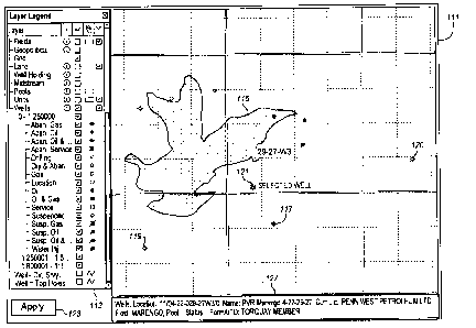
[0031] Referring to the drawing figures, Figure 1 is an example of a map of a
well field as
displayed on a computer system according to an embodiment of the invention.
The display
includes a map 111, and a layer legend 113. There may be other elements on the
display to
provide additional capabilities or information to a user. There may also be
other elements
associated with applications and operating systems, such as title bars,
notification areas, menu
selectors, hardware or program status indicators, etc. These are also not
shown in order not to
obscure the features of the invention.
[0032] The layer legend allows a user to select features of the map that are
to be visible on the
map. The features are in a variety of different categories and for wells, the
features include oil
wells, gas wells, and combined oil and gas wells. While only these types of
wells are shown in
Figure 1, the invention is not limited to such wells, but can be applied to
many different types of
wells, including water, natural gas, methane, and other gases. The layer
legend also indicates
different symbols for the different types of wells and for wells of a
different status. Accordingly,
an abandoned gas well 117 is indicated on the map with a different symbol than
an active gas
well 119. In the layer legend, the user has selected for lakes to be displayed
and accordingly,
there is a lake 115 indicated on the map. By selecting different features to
display, the user can
tailor the view of the map to focus on features that are important to the
viewer. Changing the
views and clicking "Apply" 123 allows the user to compare different views.
[0033] The map also displays grid lines and identifying numbers for the grids,
such as 29-27-
W3. This grid is a part of the Canadian grid system applied the Western
Provinces of Canada.
The lines might alternatively show latitude and longitude, county, provincial
and municipal
boundaries, or any other geographical identifiers depending on the territory
that is being
CA 02686699 2009-11-30
displayed. For undersea wells in international or territorial waters, nautical
references can be
used.
[0034] In the example of Figure 1, the user has selected a particular gas well
121. As a result,
information about the well 127 is displayed in the lower margin including its
name location,
field, pool, etc. By selecting different wells, a user can easily learn names,
and status of a variety
of wells on the maps. By making a further selection, the user can command the
system to
retrieve a log for the well and post the log in a correlation window. The
further command can be
made in a variety of ways. With a mouse, a double click, right button click,
or other command
can be used. With other input devices, a wide range of different inputs can be
used for selecting
a well and for posting its log in a correlation window. In the case of some
commands, a context
menu can be displayed with several options, one of which can be to post the
log on a correlation
window.
[0035] Figure 2 shows a display of a correlation window 131 as it might appear
on a computer
system. As with Figure 1 and the other diagrams of computer displays discussed
and described
herein, other elements of the display are not shown in order to avoid
obscuring the invention.
The illustrated portion of the display in Figure 2 has a correlation window
and a left hand side
bar. This includes a data navigator 137 that shows the names of the selected
wells. In this case,
there is only one well selected. It has a pick list of formations 139,
described below and it has a
display list 141 of formations also described below.
[0036] In the correlation window, a log 133 for the selected well 121 is
displayed. The log
includes a title bar 134 showing the name and other identifying information
about the well and
also the logged data 135 for the selected well. It may be noted that the name
of the selected gas
well, 11/04-22-029-27W3/0, appears on the title bar and the data navigator and
matches with the
information window 127 at the bottom of Figure 1. The logged data 135 shows
values for
different parameters of the well on a horizontal axis charted against the
depth of the well on the
vertical axis. In the illustrated example, seven different parameters of the
well are charted
against the depth of the well.
[0037] In addition to the charted parameters, the log also indicates the
positions of formation
tops in the well. In the illustrated example, two formation tops are indicated
and they are named
LEAPRK 143 at 198m deep, and MILKRV 145 at 330m deep. These formations are
geological
formations and can be used by an earth scientist or geologist to determine the
locations of
6
CA 02686699 2009-11-30
various material in the hole or in nearby holes. The two formations also
appear in the pick list
and the display list with an indication of the how they are displayed on the
log. LEAPRK is
displayed with a solid line, while MILKRV is displayed with a dotted line.
While the formation
tops do not appear at exactly the same depth in each well log, the depths are
usually close for
nearby wells. The order of the formations is also usually the same for nearby
wells. With
distance, the differences between wells increases and a formation that appears
in one well may
not appear at all in another well or it may be above or below another
formation as compared to
the first well.
[0038] Referring to Figure 3, the same map of the same area on the grid as in
Figure 1 is
displayed. In Figure 3, the user has selected a different gas well 119 by
hovering a cursor over it.
Information about this well is accordingly displayed in the lower margin
information window
127. By making a further selection, such as clicking or double clicking, or
right clicking, the
user can command the log for this well to be retrieved from a data store and
displayed in the
correlation window.
[0039] Figure 4 shows the correlation window 131 of Figure 2 with logs 133,
147 for both
selected wells displayed alongside one another. Like the first log, the second
log has a title bar
148 and logged data 149. The two formations 143, 145 are also displayed. With
both well logs,
the formation can be displayed on both logs. The position of the logs can be
manipulated by a
user to line up the formations or to allow different depths to be displayed
alongside one another.
In one example, the user grabs one log and then moves it up or down to adjust
its position
relative to the other. This can be done by a click and drag mouse gesture or
in a variety of other
ways.
[0040] In the display of Figure 4, both wells have a pin selection box 151.
This allows the user
to pin either one of the wells to the correlation window with single command.
In the illustrated
example, a well log is pinned by clicking the pin selection box. The user, at
any time, can click
the pin selection box for a different well to unpin the first well and pin the
different well. The
pinned well remains in the correlation window when another well is selected.
This allow the
geologist to establish one well as a reference and then to compare many
different wells to that
reference.
7
CA 02686699 2009-11-30
[0041] Figure 5 shows a display with the same map as with Figures 1 and 3. In
the example of
Figure 5, a third gas well 120 has been selected and its information is
displayed. The user can
then select that well for display in the correlation window as shown in Figure
6.
[0042] In Figure 6, the well 121 that was selected first has been pinned.
Accordingly, its log 133
remains in the correlation window 131. The log 147 of the second selected well
119, however,
has been replaced with a log 153 for the third selected well 120. As in the
previous examples,
this log has a title bar 154 identifying the well and logged data 155 showing
the values for
parameters of the well by depth. The two formations 143, 145 are also shown as
they occur on
both logs. Again, the logs are not vertically aligned, however the user can
move the logs up or
down with a simple command, for example a click and drag.
[0043] Figure 6 illustrates how additional wells can be compared to a pinned
well, simply by
selecting from the map and posting another well to the correlation window. Any
one of the wells
can be selected from the map and the map display can be moved or navigated to
show additional
wells outside of the display area of Figures 1, 3, and 5. Figures 1, 3, and 5
also illustrate that the
selected wells do not have any particular spatial relationship to each other
on the map. Any well
on the map, for which a log is available can be selected.
[0044] As a further alternative, Figure 6 shows that the data navigator 137
lists all three of the
selected wells. The user can switch the unpinned log between any one of the
three listed wells
simply by selecting one of the listed wells. All of the wells selected in a
session will be listed in
the data navigator. The user can clear the list to start a new session or
delete any particular well
from the list. These actions can be performed using a context menu or in a
variety of other ways.
A benefit of being able to select any one of the three wells is that the log
for one well can be
displayed twice in the correlation window. Using two displays of the same log,
different depths
of the same hole can be compared on the screen.
[0045] With the logs displayed, the geologist can also make annotations or
comments on the
logs. In the example of Figure 6, the depth of 272.1 lm has been marked 157.
Such a mark can
be made simply be selecting a particular depth. The system can then draw a
line on the log at
that depth. The mark can be added to the stored record of the log data or
stored in a separate
associated data file. The mark can also be annotated by adding descriptive
text. In the illustrated
example, the mark is annotated with [TVD] 159. The other two formations have
been similarly
annotated. These marks and annotations allow a geologist to make some notes
and then refer
8
CA 02686699 2009-11-30
back to them later. The marks can be moved and deleted and the annotation can
also be edited
and deleted. The results can then be saved in association with or as part of
the logs.
[0046] While the figures show only two well logs in the correlation window,
the correlation
window can be expanded to include more than two wells. Three, four, or more
well logs can be
displayed alongside each other. In such an example, more than one well log can
be pinned. In
addition, well logs can be repositioned horizontally, so that the user can
select which well logs in
the correlation window are positioned next to which other logs. A variety of
different commands
can be used such as drag and click or swiping commands. With additional logs
displayed, the
interconnecting lines that cross the correlation window can span across many
logs to show how
formations line up in different wells.
[0047] Referring to Figure 7, a flow chart of one example of the processes
described above is
shown. In the example of Figure 7 after the well log data, maps and any other
information has
been analyzed, a display is presented at block 72 of the wells for which log
data is available.
This display can be presented in the map format of Figure 1, in a list view, a
grid view, or any of
a variety of other presentations. The system then determines if one of the
presented well has
been selected at block 74. If not, then the system waits until a selection is
made or until some
other command is received to perform some other action.
[0048] At block 76, if a well has been selected, then its log is retrieved. At
block 77, the system
determines whether a user has commanded that one of the currently displayed
logs be pinned. If
so, then the system pins that log at block 79 and at block 78 the log is
presented in the correlation
window as shown by the example of Figure 2. If no log has been pinned, then at
block 78, the
second log is displayed in the correlation window. A variety of other commands
can be received
as well upon, before, or after the selection of a well log.
[0049] At block 80, it is determined whether another well has been selected,
for example by
clicking a well on a map or a list or in any of a variety of other ways. If a
second well has been
selected, then at block 82, the log for that well is retrieved and at block 84
also displayed in the
correlation window. If no second well is selected, the system waits for this
or another command.
[0050] At block 86, the system waits for a third well to be selected. If a
well is selected, then at
block 88, the system retrieves log data for the third well. At block 90, the
system determines
whether a user has commanded that one of the currently displayed logs be
pinned. If so, then the
system pins that log at block 92 and at block 94 replaces the unpinned log
with the newly
9
CA 02686699 2009-11-30
selected log from block 86. If no log has been pinned, then at block 96, the
third log is displayed
in the correlation window. Any approach can be used to select which log to
replace. The most
recently selected, the earliest selected, the right side or left side log, or
the log that corresponds to
the farthest or closest well can be selected. The particular choice of which
log to replace can be
adapted to suit any particular environment. The process then returns to block
86 for another well
to be selected.
[0051] The example of Figure 7 is well adapted for the illustrated correlation
window that
displays two well logs. For a display of more logs, there may be more pinned
logs, and the
selection of another well may not result in a log display being replaced but
in the new log display
being added.
[0052] Embodiments of the present invention not only allow well logs to be
placed side-by-side
for comparison and study, but also allow formation tops to be identified,
tagged, and correlated
across logs. To mark formation tops, well logs are placed alongside each other
in the correlation
window. This can be done using the process of Figures 1 through 7 or any of a
variety of other
ways. In one example, starting with the map of Figure 1, a user can select a
context menu, for
example with a right click, for each desired well that sends a log directly to
the correlation
window without affecting the map. In this way, several logs can be sent to the
correlation
window without moving from the map display.
[0053] Referring to Figure 8, a computer-generated display is shown that is
particularly useful
for picking well tops. As in Figure 4, a first well log 221, corresponding to
well 00/07-33-096-
05W6/0 is pinned as indicated by the pin mark 151. A second well log 223 has
been posted
beside it corresponding to well 00/07-29-096-05W6/0. These two well logs are
displayed in a
correlation window 131. While two wells are shown for simplicity, more wells
can be displayed
alongside these two, depending upon the width of the display and the
preferences of the user.
[0054] To the left side of the logs, a data navigator 137 allows the user to
switch to any other
previously selected wells. The data navigator shows seven previously selected
wells by
numerical name. Any other type of nomenclature may be used to identify the
wells in the list.
The names of the two displayed well logs are highlighted in the list for
reference. The user can
select a name whether it is highlighted or not. The log for the selected well
will then replace the
unpinned log or one of the unpinned logs. The user can pin that log by
clicking the pin mark 151
for any particular log. Other wells can be added or swapped for the current
wells by selecting
CA 02686699 2009-11-30
them from the data navigator. If a well log that is not shown in the data
navigator is desired, then
the user can manually enter the name of the well, return to the map to select
it, or select it in
another way.
[0055] Below the data navigator 137, the display shows a pick list of
formations 139. This pick
list can be established by the user or generated automatically from data about
the wells in the
data navigator. The pick list can also be modified to include formations that
have not been
associated with the displayed well logs. This can be helpful when new
formations are expected
to be found in exploratory wells.
[0056] Below the pick list 139, the display list 141 shows all of the
formations that are actually
displayed on the displayed well logs. The display list includes formations not
currently visible
on the screen but which would be visible by scrolling the view up or down. The
pick list
typically includes only some of the formations in the display list. However, a
user may be able
to add additional names to the pick list. This is helpful when identifying and
marking new
formations to the displayed logs that are not in the display list.
[0057] Both lists provide a legend that allows the lines displayed over the
well logs to be
identified with the corresponding name of a formation. For example, the
formation SLAVPT is
listed in both the pick list and the display list and is indicated as a dotted
line. On the well logs, a
dotted line is shown at about the middle of the displayed portion of the log.
This formation is
labeled as SLAVPT. The other two formations are displayed on the well logs
similarly. The
legends can take any form. While different line types are shown here,
different colors, different
animations, and other different styles can be used.
[0058] As in Figure 4, the well logs 221, 223 are arranged vertically by depth
and only a portion
of the depth of the well is displayed. There are three formations indicated on
the logs,
MUSKWA 225, SLAVPT 227, and BEAVERHL 229. In the example of this display, the
formations can be retrieved from previously stored data and then indicated on
the correlation
window display. Typically, electronic well logs include or are associated with
other data. This
data not only characterizes the well with the kind of information indicated in
the title bar for each
log but also includes other features linked to the log by depth.
[0059] Accordingly, for both wells, the MUSKWA formation is indicated as
having a top at
2266.8 lm on the left log and 2293.13 on the left log. The SLAVPT well is
indicated as having a
depth at 2316.74m on the left log and 2442.64 on the right log. The BEAVERHL
formation is
11
CA 02686699 2009-11-30
indicated as having a depth at 2395.70m for the log on the right but there is
no information about
that formation for the log on the left and so, as indicated in the diagram, no
information is
shown.
[0060] Considering the formations more carefully, the annotation for each
formation includes
"<U>." In the illustrated example, this indicates that the formation was added
to the logs by the
user. In the examples of Figures 1-6, the annotations includes "<S>." This
indicates that the
formation was placed there by the system. These examples show that embodiments
of the
present invention allow the system to retrieve data about formation and show
them on the logs.
It also allows users to annotate and mark logs with formations as they choose.
In Figure 8, while
the three formations shown on the logs are available as system information in
the logs of Figures
1-6, they have been added by a user in Figure 8.
[0061] The correlation window 131 allows a user to analyze logs and add
annotation and marks
to the logs. These can be saved for future use and reference. The formation
marks of Figure 8
can be added by selecting a formation from the pick list and then selecting a
depth on either log.
The selections can be made by clicking a mouse or in any of a variety of other
ways. In Figure
8, a new user-added formation is identified as BEAVERHL 229. This formation is
shown in the
pick list and in the display list, but is shown only in one log. The user can
add this formation to
the other log by marking a position on the other log which will automatically
be identified as the
BEAVERHL formation. In another embodiment, if the system is unable to
automatically
identify the formation, the user can select BEAVERHL from the pick list and
then apply that
selection to a selected depth.
[0062] In a typical well log, there can be very many formations and the names
may be difficult
to remember or distinguish. Accordingly, the system is able to aid a user in
identifying and
labeling logs. First, the pick list is sorted in order of depth. As can be
seen in the pick list of
Figure 8, BEAVERHL is between MUSKWA and SLAVPT formations. This order is
depth
order so that MUSKWA is above or less deep than BEAVERHL. The same
relationship appears
in the well log 223 on the right side of the correlation window. Formations
typically occur in the
same depth order throughout a well pool, but not always. Geological events can
result in folds
and inversions and any one formation may or may not occur throughout a field.
[0063] Figure 9 shows a proposed mark 231 for the BEAVERHL formation 229 on
the left side
log 221 in the correlation window 131. In one example, the system follows the
user's mouse
12
CA 02686699 2009-11-30
movements or the movement of a cursor by any other type of pointing device.
When the cursor
is moved to the left side log, the system determines that the mouse is in a
position between two
marked formations, in this case MUSKWA and SLAVPT. It then determines that the
BEAVERHL formation is between these two other formations. It then provides a
proposed mark
231 on the left side log and connects it to the BEAVERHL formation on the
right side log 223.
[0064] This provides several user benefits. First, if the user agrees with the
system suggestion,
the user can simple confirm the suggestion with the click. The user is not
required to select a
formation from the pick list or even to know which formation is most likely to
be in the selected
area. Second, it connects the suggested marker on one log with the confirmed
mark on the other
log. The user can quickly go to the marker on the other log, compare the two
logs and decide
whether the selected marker is likely to be the top for the same formation as
in the other log.
The user can then adjust the position of the suggested marker, if desired, and
then confirm the
choice. If there is no clear position for the top, then the user can reject
the suggestion and select
a different formation from the pick list or move on to another part of the
log.
[0065] In the example of Figure 9, in an actual working system, the proposed
mark 231 for
BEAVERHL will move with the cursor. In one example, the line will follow the
user's mouse.
As the mouse is moved, the depth of the indicated mark will move. If the user
moves the cursor
outside of the space between the two formations, then the system will make
another prediction.
For example, if the user were to move the cursor above the MUSKWA formation
225, the
system would follow the cursor and show a new proposed mark as a suggested
position of the
FTSIMPSON formation. This is the next formation up in the pick list. If, on
the contrary,
FTSIMPSON were already marked on the right side log, then the system would
make no
suggestion. In the case of no suggestion, the system can show a horizontal
line at the depth
corresponding to the position of the cursor, similar to the horizontal line
231. This mark can
then be left unnamed and unconnected to any formation on the left side log.
[0066] The prediction of a formation top position does not require that two
logs be displayed
side by side. The suggested mark 231 of Figure 9 can be generated without
reference to the well
log on the right. The suggestion can be made as a function of only the current
marked formation
tops and the positions of the formations in the pick list. A user can use the
right side log for
comparison and to help with identifying a formation. As mentioned above, any
well log can be
13
CA 02686699 2009-11-30
used for this purpose and the user can replace the right side well log with
one or more other logs
to aid in selecting tops and selection formation names.
[0067] Figure 10 shows a possible result when the user has confirmed a
suggested mark for the
BEAVERHL formation. In Figure 10, the same two well logs 221, 223 are shown in
the
correlation window 131. The displayed depth is increased so that now the
BEAVERHL
formation is at the top of the display. However, as shown, the BEAVERHL
formation top is
indicated on both logs and the two positions are connected through the
correlation window
between the two logs. Such a result can be obtained from the display of Figure
9 when the user
upon being satisfied with a suggestion from the system confirms the suggestion
with a mouse
click or similar user input.
[0068] Figure 10 shows that the user can also adjust the position of the logs
by dragging the logs
in one direction or another. The BEAVERHL formation top, for example is at
2217.00m on the
left log, but at 2270.00m on the right log. While the mark is aligned
horizontally between the
two wells, the corresponding depths on the wells are different. The left side
log is about 53m
higher than the right side log. The user can align the logs by grabbing and
moving or by
dragging or by any of a number of other user inputs. The system then can move
the logs
vertically on the display.
[0069] In both Figures 9 and 10, the formations do not line up at exactly the
same indicated
depth. This may be because the formations tops are higher or lower in
different places or
because different references or standards are used to determine depth, e.g.
surface of the hole,
sea level, etc.
[0070] Figure 11 shows the correlation window 131 with the same two well logs
241, 243 as in
Figures 9 and 10. However, the logs are at a different depth in the hole than
in the previous
examples. In this area of the well logs, the formation tops have not been
identified. Figure 11
illustrates how the well logs can be marked and annotated. The user has
identified an interesting
part of the left side log at 3272.84m and marked it 245. A similar looking
portion of the right
side log has also been marked. This has been annotated as My Sandstone. While
the system
may suggest existing formation names as in Figure 9 for the indicated marks,
the user can reject
these names and provide his own. "My Sandstone" can serve as a temporary
indication of what
the formation might consist of. The user can later match this up to a known
formation name. In
one embodiment the user selects a name from the pick list 139 or the display
list 141 and assigns
14
CA 02686699 2009-11-30
it to the mark. Alternatively, the marks may correspond to new, previously
unknown formations.
These can be named later in some other way.
[0071] Similarly, the user has identified other interesting areas as My
Limestone 246, My
Interesting Thing 247, and Perf Here 251. Additional depths are marked on the
right side
formation at 3375.65m deep 249 and at 3443.19m deep 253. There are no
corresponding marks
on the left side log. This may be because the user has yet to identify a
corresponding area on the
left side log or because these marks do not correspond to a formation but to
some other aspect of
the hole or its exploration or development that the user would like to note.
[0072] Figure 11 shows the flexibility within the system of finding areas of
interest in a log,
marking it and matching that area with another log. The marks can be annotated
temporarily or
permanently. By providing the pick list beside the logs, the user can easily
assign the
appropriate formation name to a particular depth. In the example of Figures 9
and 10, the user
can assent to the system's suggestion, or the user can select and assign his
own name.
Formations with the same name can be matched across the different logs and
this aids in a
comparison of the logs at the related depths.
[0073] Figure 12 is a process flow diagram of identifying and naming formation
tops as
described in the context of Figures 9, 10, and 11. At block 21, well logs are
displayed as shown,
for example in Figure 9. The system then monitors user inputs. If the user
places a cursor or
indicator at a particular depth on a log, then the system determines that
depth at block 22. The
system can then display a mark at the determined depth. This is shown, for
example, as the mark
231 in Figure 9.
[0074] To find a name for the indicated mark, the system first determines
whether the user has
selected a formation name in the pick list 139 at block 23. If so, then at
block 31, the system
determines whether the selected formation name from the pick list is a
formation that has already
been identified on the log in a different location. If this formation name has
not already been
assigned to some other depth, then at block 33, the selected name from the
pick list is displayed
on the well log as the proposed name. If the selected name from the pick list
has already been
used, then another process is used to determine how to propose a name for a
formation top 35.
[0075] Returning to block 23 if the user has not selected a formation name
from the pick list then
at block 25, the system determines if there are formations in the pick list
that could be picked. If
so, then the system picks an unpicked formation name from the pick list at
block 27. If there are
CA 02686699 2009-11-30
no other unpicked formation names in the pick list then no formation top name
is suggested and
at block 29, the user can turn to other processes to name, annotate,
correlate, or identify
formation tops. In this context, an unpicked formation suggests a formation
that has not already
been identified in the well log and assigned to a particular depth. In such a
case, the formation is
available to be assigned to any depth that the user may choose.
[0076] Returning to block 35, if the formation selected by the user already
appears on the well
log at block 31, then the system can still select a formation name to propose.
The system can
begin at block 35 by determining whether the cursor is above or below a
formation top that has
already been named. If the cursor is above a formation top then at block 37 if
there are unpicked
formations above that top, the system can use the next formation above that
formation as the
proposed name at block 39. If there are no more formation names above that
formation top then
no formation name is selected and the process returns to wait for a new cursor
position at block
22 or the user can turn to other processes 29.
[0077] Similarly if the cursor is below a formation top at block 35, then at
block 41 the system
can determine whether there are unpicked formations in the pick list below
that formation. If so
then the first unpicked formation can be selected at block 43 as the proposed
name. If there are
no unpicked formations below that formation, then the process ends. The system
can return to
block 22 to determine new cursor position or the user can invoke other
processes 29.
[0078] In one embodiment, the processes of Figure 12, result in a smooth and
refined user
experience and workflow that improves the ease of assigning and correlating
formation names on
displayed well logs. In one mode, the user selects a formation from the pick
list and then moves
the cursor over the log. The system then displays a mark, such as the
horizontal mark 231 of
Figure 9 that follows the cursor, displays the selected name and draws a line
to connect that mark
to the corresponding formation top on any other displayed well log for which
that formation has
been identified. This allows the user to easily compare the logs to determine
if the same
formation is present in both.
[0079] In another mode, the user starts at a named formation top on a log. By
moving the cursor
up, a mark is displayed that follows the cursor movement. If there is an
available formation
name for a formation above the starting formation, then that name is
displayed. As in the other
case, the system also connects that mark to the formation of the same name on
any of the other
displayed well logs. Alternatively, the user can move the cursor down from the
starting
16
CA 02686699 2009-11-30
formation. A mark is again displayed and the if there is an available
formation name below the
starting formation, then that name is displayed together with the connection
to the same
formation in the other logs.
[0080] The user can, accordingly, use cursor movements around the well logs to
see different
formation suggestions and see how those formation tops compare to already
established
formation tops in other wells. The user can also use the pick list to look at
other correlations.
The operations starting at block 23 mean that among other things, any
formation can be selected
from the pick list. The system determines if the selection is valid or not.
[0081] In response to any proposed name, the user can confirm the selected
name using an
appropriate command such as a click, a double click, selecting from a
contextual menu, using a
keystroke, etc.
[0082] In the example of Figure 12, the nearby formation names are selected at
blocks 27, 33,
39, and 43 by reference to the pick list. The pick list will typically have
all of the available
formation names and can include some additional ones that the user has
defined. However, the
nearby formation can be selected in a variety of different ways depending on
the particular
application. In one example, the system retrieves the name of the formation
directly above the
selected depth and then refers to the pick list to choose the next formation
down in the list.
Alternatively, the system can retrieve the name of the formation directly
below the selected
depth and then select the next formation up in the pick list. In a further
improvement, if the
selected formation name has already been assigned to a particular depth, then
the system can skip
that name and choose the next name. Alternatively, it can indicate a
placeholder or no name.
[0083] Alternatively, to further improve the suggested formation name, the
system can retrieve
formation names at depths both above and below the selected depth, select the
closest formation
and then select the next name up or down in the pick list. If a formation
above the selected depth
is closer, then the system can choose the name of the next formation down in
the pick list. If a
formation below the selected depth is closer, then the system can select the
name of the next
formation up in the list.
[0084] As a further alternative, the system can consider formation names in
neighboring well
logs that are between named formations or are at the selected depth. A variety
of different
methods can be used to propose a formation name at a selected depth. In any
event, the user can
exercise the choice of using the propose name, selecting a different name from
a list or providing
17
CA 02686699 2009-11-30
a new name. As indicated in Figure 11, other annotations can also be used
instead of a name.
This allows the user to annotate items in the well logs that are not formation
tops and it allows
the user to mark formations without knowing an established name for the
formation.
[0085] Figure 13 is an example of a computer system upon which embodiments of
the present
invention may be implemented. The computer system 300 comprises a bus or other
communication means 301 for communicating information, and a processing means
such as a
processor 302 coupled with the bus 301 for processing information. A random
access memory
(RAM) or other dynamic storage device 304 (referred to as main memory),
coupled to the bus
301 stores information and instructions to be executed by the processor 302. A
read only
memory (ROM) or other static storage device 306 is coupled to the bus 301 for
storing static
information and instructions for the processor 302. A mass storage device 307
such as a
magnetic, optical, or solid-state disk is coupled to the bus storing
information and instructions.
[0086] The bus 301 also provides connections to external devices such as a
display device 321
for displaying information as presented in the above figures to an end user.
Typically, an
alphanumeric input device, such as a keyboard, mouse, touchpad, number pad, or
stylus pad 322
to allow the user to send the commands discussed above. The user input/output
devices can also
include voice or gesture recognition devices. The bus 301 also provides
connection to a remote
data store. This data store may be an independently provided source or well
logs, maps and
other relevant data for use by the system 300. The remote data can be combined
with data stored
locally 307 to generate the displays described above. Similarly local or
remote data storage may
be used to store the marks and annotation that are added by the user as
described above.
[0087] A remote communication device 325 is also coupled to the bus 301. The
communication
device 325 may include a modem, a network interface card, or other well-known
wired or
wireless interface devices, such as those used for coupling to Ethernet, token
ring, or other types
of physical attachment for purposes of providing a communication link to
support a local or wide
area network, for example. In this manner, the computer system 300 may be
coupled to a
number of clients or servers via a conventional network infrastructure, such
as a company's
Intranet or the Internet, for example. The system may obtain some or all of
the log and map data
remotely through the communication device. The data may be combined with data
in one or
more other stored locations.
18
CA 02686699 2009-11-30
[0088] It is appreciated that a lesser or more equipped computer system than
the example
described above may be desirable for certain implementations. Therefore, the
configuration of
the system will vary from implementation to implementation depending upon
numerous factors,
such as price constraints, performance requirements, technological
improvements, and/or other
circumstances.
[0089] It should be noted that, while the steps described herein may be
performed under the
control of a programmed processor, such as processor 302, in alternative
embodiments, the steps
may be fully or partially implemented by any programmable or hardcoded logic,
such as Field
Programmable Gate Arrays (FPGAs), TTL logic, or Application Specific
Integrated Circuits
(ASICs), for example. Additionally, the method of the present invention may be
performed by
any combination of programmed general purpose computer components and/or
custom hardware
components. Therefore, nothing disclosed herein should be construed as
limiting the present
invention to a specific combination of hardware components.
[0090] While the steps described herein can be performed under the control of
a programmed
processor, such as the processor 702, in alternative embodiments, the steps
can be fully or
partially implemented by any programmable or hard coded logic, such as Field
Programmable
Gate Arrays (FPGAs), TTL logic, or Application Specific Integrated Circuits
(ASICs), for
example. Additionally, the method of the present invention can be performed by
any
combination of programmed general purpose computer components or custom
hardware
components. Therefore, nothing disclosed herein should be construed as
limiting the present
invention to a particular embodiment wherein the recited steps are performed
by a specific
combination of hardware components.
[0091] The present description presents the examples using particular terms,
such as mouse,
cursor, pick list, display list, mark, and annotation. These terms are used to
provide consistent,
clear examples, however, the present invention is not limited to any
particular terminology.
Similar ideas, principles, methods, apparatus, and systems can be developed
using
different terminology in whole, or in part. In addition, the present invention
can be applied to
ideas, principles, methods, apparatus, and systems that are developed around
different usage
models and hardware configurations.
19
CA 02686699 2009-11-30
[0092] The present invention is described in terms of gas wells and fields.
However, a wide
range of different types of well logs covering any type of logged hole
operated on using the
present invention.
[0093] In the present description, for the purposes of explanation, numerous
specific details are
set forth in order to provide a thorough understanding of the present
invention. However, the
present invention can be practiced without some of these specific details. In
other instances,
well-known structures and devices are shown in block diagram form. The
specific detail can be
supplied by one of average skill in the art as appropriate for any particular
implementation.
[0094] The present invention includes various steps, which can be performed by
hardware
components or can be embodied in machine-executable instructions, such as
software or
firmware instructions. The machine-executable instructions can be used to
cause a general-
purpose or special-purpose processor programmed with the instructions to
perform the steps.
Alternatively, the steps can be performed by a combination of hardware and
software.
[0095] The present invention can be provided as a computer program product
that can include a
machine-readable medium having stored instructions thereon, which can be used
to program a
computer (or other machine) to perform a process according to the present
invention. The
machine-readable medium can include, but is not limited to, floppy diskettes,
optical disks, CD-
ROMs, and magneto-optical disks, ROMs, RAMs, EPROMs, EEPROMs, magnet or
optical
cards, flash memory, or any other type of medium suitable for storing
electronic instructions.
[0096] Although this disclosure describes illustrative embodiments of the
invention in detail, it is
to be understood that the invention is not limited to the precise embodiments
described. The
specification and drawings are, accordingly, to be regarded in an illustrative
rather than a
restrictive sense. Various adaptations, modifications and alterations may be
practiced within the
scope of the invention defined by the appended claims.