Note : Les descriptions sont présentées dans la langue officielle dans laquelle elles ont été soumises.
CA 02689289 2009-11-27
WO 2008/137589 PCT/US2008/062284
CALCULATING AN ET VALUE FOR AN IRRIGATION AREA
FIELD OF THE INVENTION
[0001] The present invention generally relates to characterizing weather
information. More specifically, the invention relates to calculating an ET
value for an
irrigation area.
BACKGROUND OF THE INVENTION
[0002] Typically, weather data, such as temperature or atmospheric pressure,
is measured from a physical weather station or other physical weather
parameter
measuring device at a particular location. This weather data provided is
generally
collected, stored and made available to a user. The user upon collecting or
receiving
the weather data can further analyze, or make additional calculations using
this
weather data. For example, a user might take one or more weather parameters,
such
as temperature and calculate Evapotranspiration (ET), or amount of water used
by a
plant for those measured weather conditions. The user may then manually enter
or
communicate this value to an irrigation controller which in turn calculates
the
appropriate amount of irrigation based on the ET and the user input
information.
[0003] Figure 1 shows a prior art irrigation system in which a local weather
station 1121ocated within an irrigation area 130 provides weather information
that
can be used to control an irrigation system 140 within the irrigation (site)
area 130.
The weather information can be stored in non-local storage 114, but still
represents
the weather at the site of the irrigation system. The irrigation system can
also receive
weather parameters from a non-local data source 116 (such as a satellite), but
the data
(weather information) of the non-local data source 116 reflects weather of the
site
(irrigation) area 130. A processor 150 receives the irrigation area weather
information and controls the irrigation system 140.
[0004] Irrigation systems that include the above-described controller to
control the amount of irrigation based on calculated ET can be sub-optimal
because
CA 02689289 2009-11-27
WO 2008/137589 PCT/US2008/062284
the physical weather measuring parameter device may be located somewhere other
than where the irrigation area is located. Therefore, the calculated ET may
not
provide an accurate estimate of the irrigation required because the ET is
calculated
based on physical weather measurements that do not accurately represent the
weather
at the irrigation area.
[0005] Additionally, ET is generally calculated using grid based processing.
With grid based processing, a value for a weather parameter to be used in the
calculation of the ET is estimated using an average of the weather parameter
within a
specified cell of a grid. A disadvantage of grid based processing is that a
weather
parameter in the grid cell may have large variation within the grid.
Typically, the
weather parameter is averaged across the cell of the grid. This can result in
a loss in
accuracy depending on the weather parameter, the adjacent or associated
weather
parameters, and grid cell size.
[0006] It is desirable to accurately calculate an ET value for an irrigation
area,
when data for calculating the ET in the irrigation area is not available.
SUMMARY OF THE INVENTION
[0007] An embodiment of the invention includes a method of calculating an
ET value for an irrigation area. The method includes a weather parameter
measurement system collecting at least one weather parameter of a weather
parameter
area, the at least one weather parameter of the weather parameter area
providing a
representation of weather outside of the irrigation area. An irrigation area
weather
parameter is calculated providing a representation of weather within the
irrigation
area from the at least one weather parameter of the weather parameter area.
The ET
value for the irrigation area is calculated from an N-dimensional continuous
function
using the at least one irrigation area weather parameter, wherein the N-
dimensions
includes at least a 3-dimensional spatial cube.
[0008] Another embodiment of the invention includes a method of providing a
non-measured weather related parameter to an irrigation system. The method
2
CA 02689289 2009-11-27
WO 2008/137589 PCT/US2008/062284
includes a weather parameter measurement system collecting at least one
weather
parameter of a weather parameter area, the at least one weather parameter of
the
weather parameter area providing a representation of weather outside of the
irrigation
area. An irrigation area weather parameter is calculated providing a
representation of
the weather parameter within the irrigation area from the at least one weather
parameter outside of the weather parameter area. A non-measured weather
parameter
is calculated for the irrigation area from an N-dimensional continuous
function using
the at least one irrigation area weather parameter, wherein the N-dimensions
includes
at least a 3-dimensional spatial cube. The non-measured weather related
parameter is
provided to the irrigation system, and the irrigation system controls
irrigation of an
irrigation area based on the non-measured weather related parameter.
[0009] Reference to the remaining portions of the specification, including the
drawings and claims, will realize other features and advantages of the present
invention. Further features and advantages of the present invention, as well
as the
structure and operation of various embodiments of the present invention, are
described in detail below with respect to accompanying drawings, like
reference
numbers indicate identical or functionally similar elements.
BRIEF DESCRIPTION OF THE DRAWINGS
[0010] Aspects, advantages and novel features of the present invention will
become apparent from the following description of the invention presented in
conjunction with the accompanying drawings:
[0011] Figure 1 shows a prior art system for controlling irrigation of an
irrigation area;
[0012] Figure 2 shows a system for collecting weather parameters of areas
outside of the irrigation area that can be used for calculating an ET value
for an
irrigation area;
[0013] Figure 3 is a flow chart that includes steps of an example of a method
of calculating an ET value for an irrigation area;
[0014] Figures 4A and 4B show comparisons between a grid and a continuous
function;
[0015] Figure 5 is a block diagram of an example of a system that implement
the method of Figure 3;
3
CA 02689289 2009-11-27
WO 2008/137589 PCT/US2008/062284
[0016] Figure 6 is a flow chart that includes steps of an example of a method
of providing a non-measured weather related parameter to an irrigation system.
DETAILED DESCRIPTION
[0017] ET can be used to determine the amount of water needed to maintain
plant health and conserve water of an area to be irrigated. If the weather
parameters
required to compute the ET are not measured at that location (that is, at the
irrigation
location), then non-optimal or inappropriate irrigation can occur. ET can be
calculating using a wide variety of equations, such as, a Penman-Moneith or a
Penman-Montieth derived equation. Many of these equations require multiple
weather parameters that are not commonly measured at locations where there are
ET
calculation requirements. That is, the weather parameters are not typically
available,
for example, at an irrigation area where an ET value is desired for
determining
irrigation requirements for the irrigation area.
[0018] One embodiment of calculating ET uses a Penman-Monteith or
Penman-Montieth derived equation that is generally used for the calculation of
daily
values, for example:
0.408L(R,, -G)+y 900 L~ (e. -ej
ET¾ = T+273
^+y 1+0.3Au2
where ET is reference evapotranspiration [mm day'], R. is net radiation at
the crop surface
[MJ m, day'], G is soil heat flux density [MJ m, day'], T is mean daily air
temperature at 2 m
height [ C], uz is wind speed at 2 m height [m s-'], es is saturation vapour
pressure [kPa], ea is
actual vapour pressure [kPa], es - ea saturation vapour pressure deficit
[kPa], A slope vapour
pressure curve [kPa C'], ypsychrometric constant [kPa C'].
[0019] Evapotranspiration (ET) is defined as the amount of water that
evaporates from vegetation (transpiration) and from the underlying soil
(evaporation).
Evaporation and transpiration occur simultaneously and there is no easy way of
distinguishing between the two processes. The combined process,
Evapotranspriation
4
CA 02689289 2009-11-27
WO 2008/137589 PCT/US2008/062284
(ET) is the numerical value used to control the irrigation within a geographic
area.
Reference Evapotranspiration is defined as the calculated ET that occurs from
a
standardized "reference" crop such as clipped grass or alfalfa. The
calculation of the
Reference ET from the vegetative surfaces, and for standardization purposes,
utilizes
a short, well-water grass or a taller, well-watered alfalfa crop fort the
baseline. The
terms suggested for use by the ASCE, for the standardized short reference is
ETos,
and for the standardized tall reference ETrs. Here, the term ET refers to the
calculated Reference Evapotranspriation term ETos.
[0020] The ET equation provided as well as many others, require multiple
weather parameters that are not commonly measured at locations where the ET
calculations are required. If the weather parameters required for calculation
of the ET
values are not measured at that location, then non-optimal or inappropriate
irrigation
can occur. Typically, the weather parameter data needed for these calculations
comes
from weather stations. However, the weather stations are typically extremely
sparse,
and often are located at large distances away or in places that are not
optimal for local
use (that is, use where the irrigation area is located). Therefore, accurate
calculated
weather parameter data for specific areas is very valuable.
[0021] Irrigation systems that use weather parameters measured at a location
different than the location of the irrigation have other issues as well. For
example, the
data collected or received does not necessarily accurately reflect the local
weather
conditions that are applicable to the areas covered by the irrigation system.
The
weather station may be located in an area where the weather conditions vary
significantly from those of the areas covered by the irrigation system. As a
result, the
weather parameters which are based on data collected from the weather station
may
cause the irrigation system to provide irrigation that is not appropriate for
the local
conditions. Systems that rely upon weather data, must either measure all the
weather
parameters for the location of interest, or only use a limited number of
measured
weather parameters. Non-optimal irrigation can result by combining the limited
number of measured weather parameters with measured weather parameter data
from
outside the irrigation area.
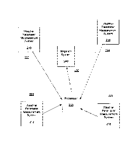
[0022] Figure 2 shows one example of a system for measuring weather
CA 02689289 2009-11-27
WO 2008/137589 PCT/US2008/062284
parameters that can be used for calculating an ET value for an irrigation
area. The
system includes weather parameter measurement systems 210, 212, 214, 216 for
collecting and/or providing weather parameters. For the embodiment of Figure
2, a
first weather parameter measurement system 210 is located in a first area 220,
a
second weather parameter measurement system 212 is located in a second area
222, a
third weather parameter measurement system 214 is located in a third area 224,
and a
fourth weather parameter measurement system 216 is located in a fourth area
226. As
shown in Figure 2, the weather parameter measurement systems 210, 212, 214,
216
can be located in areas different than an irrigation area 230. The four
weather
parameter measurement systems 210, 212, 214, 216 shown in Figure 2 are merely
examples. That is, there can be more or less weather parameter measurement
systems
than shown in Figure 2. However, none of the weather parameter measurement
systems are required to be located within the irrigations area 230, nor do
they need to
provide measurement data reflecting weather within the irrigation area 230.
This is
very desirable because weather parameter measurement systems are not always
available within irrigation areas. For one embodiment, the weather parameters
measurement systems 210, 212, 214, 216 are located in terrestrial areas that
are at
different locations than the irrigation area 230.
[0023] It should also be noted that the weather parameters collected by the
weather measurement systems 210, 212, 214, 216 can represent weather for areas
that
are outside of the irrigation area. The weather parameters representing
weather for
one or more areas outside the irrigation area can be used to calculate an
irrigation area
weather parameter. For one embodiment, this calculation can be performed, for
example, by executing a numerical weather model in which one or more weather
parameters from outside the irrigation area are used as inputs to the
numerical weather
model. Exemplary numerical weather models (NWM) may include, but are not
limited to, a NCAR/Pen State MM5 or a NOAA/NWS WRF. These and other models
are well-known. For another embodiment, an irrigation area weather parameter
can
be calculated by interpolating between weather parameters that each represent
weather in areas outside of the irrigation area.
[0024] Examples of weather parameter measurement systems include, for
example, weather stations. Generally, a weather station is a facility with
instruments
6
CA 02689289 2009-11-27
WO 2008/137589 PCT/US2008/062284
and equipment to measure, record, and transmit weather observations. This is
done
by monitoring and measuring atmospheric conditions. Typical weather stations
measure temperature, barometric pressure, humidity, wind speed, wind
direction, and
precipitation. Advanced weather stations also measure both long wave and short
wave solar radiation, and may include soil moisture, soil temperature. Another
type
of weather parameter measurement systems may be a satellite observations
system,
aircraft, ships, floating buoys, and balloons called radiosondes.
[0025] Generally, a weather parameter can be defined as data that describes
the state of the atmosphere at a given place and time. A non-exhaustive list
of
examples of weather parameters includes temperature, barometric pressure,
humidity,
wind speed, wind direction, precipitation, solar radiation, ground
temperature, along
with the date time and location that the measurements were taken.
[0026] A processor 250 (that can be located anywhere) receives the weather
parameters from the weather parameter measurement systems 210, 212, 214, 216
and
computes, for example, an ET value at a point or area, which is can be defined
by
latitude, longitude, elevation or more generally, as x, y, z coordinates of a
spatial
cube. The ET value at the point or area is calculated from a continuous N-
dimensional continuous function. Additional weather factors can also be used
in both
weather parameter and ET value calculations.
[0027] The ET value can be used to control, for example, an irrigation system
240 that in turn controls irrigation of an irrigation area 230. The ET value
provides an
accurate representation of the weather at a local area, such as, the
irrigation area 230.
[0028] The ET value is calculated based on a number of parameters including,
for example, temperature, wind speed and solar radiation. The number of
parameters
may change depending on the methodology that is used to calculate the ET
value.
The weather parameter measurement systems 210, 212, 214, 216 collectively
provide
information on these parameters. Each weather parameter measurement systems
210,
212, 214, 216 may provide information corresponding to one or more parameters.
The information is then used to compute the ET value. Data from weather
parameter
measurement systems 210, 212, 214, 216 is useful because the area 230 in which
the
7
CA 02689289 2009-11-27
WO 2008/137589 PCT/US2008/062284
irrigation system 240 is located may not have sufficient measuring apparatus
to derive
information that is needed to determine the ET value in the irrigation area
230.
[0029] Figure 3 is a flow chart that includes steps of an example of a
method of calculating an ET value for an irrigation area. As described above,
the ET
value can be used to aid in the control of an irrigation system. A first step
310 of the
method includes a weather parameter measurement system collecting at least one
weather parameter of a weather parameter area, the at least one weather
parameter of
the weather parameter area providing a representation of weather outside of
the
irrigation area. A second step 320 of the method includes calculating an
irrigation
area weather parameter providing a representation of weather within the
irrigation
area from the at least one weather parameter of the weather parameter area. A
third
step 330 includes calculating the ET value for the irrigation area from an N-
dimensional continuous function using the at least one irrigation area weather
parameter, wherein the N-dimensions includes at least a 3-dimensional spatial
cube.
[0030] Various methods can be used to estimate an irrigation area weather
parameter based on weather parameters that represent weather conditions in
locations
or area outside of the irrigation area. For example, the previously described
numerical weather model can be used with the at least one weather parameter of
the
weather parameter area.
[0031] In addition to the weather parameter measurement system described
above, another embodiment additionally includes a second weather parameter
measurement system collecting at least one second weather parameter of a
second
weather parameter area, wherein the at least one second weather parameter of
the
second weather parameter area provides a representation of weather outside of
the
irrigation area. An irrigation area weather parameter is calculated using the
initial
weather parameter and the at least one second weather parameter outside of the
weather parameter area.
[0032] One embodiment includes the irrigation area weather parameter being
calculated by an interpolation between the at least one weather parameter and
the at
least one second weather parameter. This allows for the calculation of the
irrigation
8
CA 02689289 2009-11-27
WO 2008/137589 PCT/US2008/062284
area weather parameter when, for example, no measured data for the irrigation
area is
available.
[0033] Another embodiment includes the irrigation area weather parameter
being determined using a numerical weather model. The one weather parameter
and
the second weather parameter that represent weather for areas outside of the
irrigation
area are input to a numerical weather model, providing the irrigation area
weather
parameter. As previously described, exemplary numerical weather models (NWM)
may include, but are not limited to, a NCAR/Pen State MM5 or a NOAA/NWS WRF.
The model type can vary depending upon the particular irrigation area and
conditions.
[0034] As described and shown in Figure 3, the ET value is calculated from an
N-dimensional continuous function using the at least one irrigation area
weather
parameter. An N-dimensional continuous function is any continuous function
that is
fully described with N variables. The term continuous means that for small
change in
the input variables there exists a small change in the function result. For
one
example, wind speed can be calculated at a non-local point by converting the
wind
speed into U, V and W components, where U, V and W are zonal, meridional and
vertical components. The zonal component is an east-west component, the
meridional
component is a north-south component, and the vertical component is an up-down
component. Provided there are more than two known measured or modeled points,
a
continuous surface can be created for each of the U, V and W components using
a
thin plate spline, or by using a modified numerical weather model that
provides
continuous surfaces. The speed can then be calculated at any point on this
continuous
surface with the equation:
Speed = square root ( U*U + V*V + W*W), where the U, V and W values are
extracted via a function from the continuous surfaces at a location x, y, z
and
time.
[0035] This method provides calculated weather parameters from measured
weather parameters by using the weather conditions of area(s) outside of the
irrigation
area, which in this exemplary case is wind speed. Similar equations and
function can
be used to determine all of the weather parameter data needed to calculate ET.
9
CA 02689289 2009-11-27
WO 2008/137589 PCT/US2008/062284
[0036] One exemplary method of calculating a weather parameter, such as
temperature, includes determining domain boundaries, such as the United
States.
First, a set of measured temperatures from weather stations through out the
domain
area are obtained. Next, these temperatures are converted to sea level
temperatures
for each location based on a simple lapse rate calculation such as: Sea Level
Temperature in C = Temperature in C at height Z in meters - (Z*( 6.5/1000.0
)),
where the lapse rate is assumed to be 6.5 degrees C per 1000 meters. Another
exemplary method of calculating the lapse rate includes using the N-
dimensional
function and allowing the lapse rate to vary in both time and space instead of
the
fixing the lapse rate as described above. This method provides a more accurate
representation of the lapse rate weather conditions across a large
geographical area.
[0037] Once all the individual point temperatures values are on the same
elevation plane, in this case sea level, a grid of the temperatures across the
domain are
determined using an application such as a thin plate spline. This creates a
surface of
points that is continuous in nature of non-measured sea surface temperatures.
This is
significantly different then the type of grid that is used in numerical
weather models
(NWM). A NWM grid cell represents the average of the value of all the values
within
the bounds of the cell. Whereas a thin plate spline creates a surface that
passes each
of the z value at all x, y locations. In this case the z value is the sea
level temperature.
A cubic convolution of this surface and the nearest 16 control points in x, y
space can
be used to provide the sea level temperature at any x, y location within the
surface.
To expand the function to include time dimension in the example describe, at
least
two sea level surfaces of temperature are required at times T1 and T2. The
function is
then expanded to use the new dimension of time. To return the temperature on
the
surface of the ground, the elevation term, and the original lapse rate
function is used
to create a similar temperature surface for each time T1 and T2. This type of
calculation using weather factors and one or more N-dimensional functions
similar to
those used to calculate temperature can be used for other weather parameters
such as
wind speed, humidity, and solar radiation.
[0038] One embodiment includes a method of calculating an ET value using
the N-dimensional function, and at least one collected weather parameter that
CA 02689289 2009-11-27
WO 2008/137589 PCT/US2008/062284
represents weather outside of the irrigation area. This is important and non-
obvious
because it can provide one or more weather parameters for a location that does
not
have a measured weather parameter for the irrigation area. Calculating the ET
value
is important, for example, in calculating ET, or calculating an amount of
water used
by a plant for given weather conditions. The calculation of the ET value is
also useful
because it provides information to an irrigation control system, enabling
maximization of water conservation by only irrigating with the amount of water
needed. However, since most irrigation control systems do not also have a
local
weather station which provides all the required weather parameters to
calculate ET,
there is a need to provide non-measured weather parameters that are local to
the
irrigation control system.
[0039] The usefulness of providing local non-measured weather parameters
can be extended to other areas and applications. For example, other exemplary
areas
and applications include, but are not limited to, weather damage assessments
for
insurance purposes, utility energy management and budgets, highway and
railroads to
mitigate weather related issues, and farm or agriculture application
[0040] Traditionally, to calculate ET values, and non-measured weather
parameters, practitioners use grid based processing. This process generates
non-
measured weather parameters that are fit into a matrix of cells with discrete
values in
each cell. This is not, and does not provide a continuous function of weather
parameters. The quality of the value in each cell is dependant on the quality
of the
calculations to determine the non-measured weather parameter and the grid cell
size
(resolution). The calculations of weather parameters described differ from
grid based
processing by using an N-dimensional continuous function to calculate weather
parameters. This provides a resolution independent method to calculate weather
parameters and ET values, which can be much more computationally efficient and
accurate. Grid based processing is also lacking because the weather parameter
in a
grid cell is only the average value weather parameter over a relatively large
geographic area. The weather parameter may actually have large a variation
that is
muted by this average. This is particularly problematic in areas that include
mountains or valley areas, or in regions in close proximity of large bodies of
water or
rivers.
11
CA 02689289 2009-11-27
WO 2008/137589 PCT/US2008/062284
[0041] Calculating ET values and non-measured weather parameter based on
an N-dimensional function, allows determination of the desired parameter(s)
for any
point in space or time. The function is determined by knowing the desired
weather
parameter, and the specific physics based equations that will provide desired
weather
parameter and the weather factors that are required by the function to provide
the
desired weather parameter.
[0042] Figures 4A and 4B show an exemplary grid function 410 and an
exemplary continuous function 420. The grid function 410 includes
discontinuous
points whereas the continuous function 420 does not include these
discontinuities.
The continuous function of Figure 4B is of only one dimension rather than the
greater
than three dimensions of the N-dimension continuous function of the ET value
calculations. A continuous function provides a value for a given set of input
parameters. For example, for every input time t, a continuous function
provides a
temperature T at location x, y, z that may vary assuming the temperature was
collected continuously. However, if the temperature T at location x, y, z is
only
collected every hour, then the temperature for any time within that hour is
the same
temperature, and the function is discontinuous.
[0043] As previously stated, the ET value can be calculated from an N-
dimensional continuous function using the at least one irrigation area weather
parameter, wherein the N-dimensions includes at least a 3-dimensional cube and
wherein N is greater than 3. For an embodiment, the N-dimensions of the
continuous
function includes, for example, at least latitude, longitude, elevation.
[0044] For one embodiment calculating the ET value for the irrigation area
includes calculating irrigation area weather parameters for the irrigation
area for a
desired time using the N-dimensional continuous function which includes at
least one
collected or calculated weather parameter for locations outside of the
irrigation area.
Another embodiment additionally includes at least one weather factor. The
weather
factor can be, for example, topography, slope, aspect, soil conditions,
vegetation
indexes, and land use types.
12
CA 02689289 2009-11-27
WO 2008/137589 PCT/US2008/062284
[0045] The temperature parameter component of an N-dimensional function
can be adaptively updated depending on a comparison of non-measure weather
parameters and measured weather parameters from a data source (such as, a
weather
station). For example, a non-measured weather parameter, such as, temperature
can
be compared with a measured temperature at x, y and z locations where measured
temperatures are available. A lapse rate function can then be adaptively
updated
accordingly to provide a better calculated temperature at any/all locations.
In turn, ET
values are updated wherever temperature values are updated. The methods of
adaptively updating can be used for most of the calculated weather parameters.
[0046] An ET component N-dimensional function can be updated, for
example, based on an impact of the ET value. More specifically, the ET value
can be
used to control irrigation of an irrigation area. The impact can be gauged by
determining an adequacy of an irrigation system that is at least partially
controlled by
this ET value. This can be determined by measuring how adequate the
application of
water in the irrigation area is by observing the total health of plants within
the
irrigation area, or by monitoring soil moisture probes that provide a
measurement of
the soil moisture.
[0047] Another embodiment includes selecting the frequency at which the ET
value is calculated. For one embodiment, the ET value is calculated at a rate
that is
greater than a Nyquist frequency of a dominant harmonic of the natural cycle
of the
ET value. That is, generally, the ET value has a natural cycle over a period
of time.
The cycle can be, for example, defined by a daily minimum and maximum value.
Once the frequency of the natural cycle has been determined, the frequency at
which
the ET value should be calculated can be determined. Other factors that may
affect
this natural cycle may be static in nature, or dynamically changing. A static
example
is the high desert where the natural daily temperature cycle is significantly
different
than the natural cycle in the great plains regions. A dynamic changing example
is a
warm or cold slow moving air mass. Both of these examples, along with others,
affect the natural ET cycle.
[0048] Depending upon the natural cycle of the ET value, the ET value can be
conveniently calculated at a rate adequate to define the natural cycle. The
rate used is
13
CA 02689289 2009-11-27
WO 2008/137589 PCT/US2008/062284
selected at a value greater than the Nyquist frequency. The rate can be
selected as
daily, hourly or by the minute depending on the conditions and the needs of
the ET
value application.
[0049] Figure 5 is a block diagram of an example of a system that implements
the method of Figure 3. One or more weather parameter measurement systems can
measure or collect weather parameters that represent weather conditions within
areas
or at locations outside of the irrigation area, as depicted by blocks 512,
514. Here, the
first step 310 of Figure 3 is completed, and depicted by the block 510.
[0050] The weather parameters that represent weather conditions within areas
or at locations outside of the irrigation area can be used to calculate or
estimate one or
more irrigation area weather parameter(s), as depicted by block 520. Here, the
second
step 320 of Figure 3 is completed, and depicted by the block 520. Weather
factors
can additionally be used to calculate the irrigation area weather parameter.
As
previously described, the irrigation area weather parameters can be calculated
using a
numerical weather model in which the non-irrigation area weather parameters
are
input to the model. Also as described, the irrigation area weather parameters
can be
calculated by interpolating between non-irrigation area weather parameters.
[0051] Next, the third step 330 of Figure 3 is depicted by the block 530. The
one or more calculated irrigation area weather parameters are used to
calculate an ET
value for the irrigation area.
[0052] As shown by the block 532, the irrigation are weather parameters can
be for x, y and z locations. Additionally, the irrigation area weather
parameters can
be for various times t. Varying the weather calculations with time can be
desirable
due to the fact that the weather generally changes with time. For example,
temperature, is generally cooler at night, warms slightly in the morning, more
by the
middle of the day, and starts to cool off again in the evening. The rate and
timing of
these changes is critical to the accuracy of the ET calculations in the
irrigation area.
[0053] The block 534 shows the calculation of an ET value using an N-
dimensional function, in which the spatial cube weather parameters of block
532 are
14
CA 02689289 2009-11-27
WO 2008/137589 PCT/US2008/062284
the inputs to the N-dimensional function.
[0054] As depicted by block 540, the calculated ET value is used to control
irrigation of the irrigation area.
[0055] A fundamental purpose for collecting non-local weather factors is to
allow for an accurate calculation of the weather parameters inside of the
irrigation
area. This in turn provides a more optimal usage of water in the irrigation
area. An
example of a non-local weather factor is topography. For example, if the
irrigation
area is in the flat part of a wide valley, and to the west of the irrigation
area is a
mountain ridge that is significantly higher in elevation, then surrounding
irrigation
area topography information can be used to improve calculation of weather
parameters inside the irrigation area. Also, for example, if there is a
downslope wind
out of the west, and off of the mountains, a significant temperature increase
in the
irrigation area can result from a non-local weather factor.
[0056] Figure 6 is a flow chart that includes steps of an example of a method
of providing a non-measured weather related parameter to an irrigation system.
A
first step 610 of the method includes a weather parameter measurement system
collecting at least one weather parameter of a weather parameter area, the at
least one
weather parameter of the weather parameter area providing a representation of
weather outside of the irrigation area. A second step 620 includes calculating
an
irrigation area weather parameter providing a representation of the weather
within the
irrigation area from the at least one weather parameter outside of the weather
parameter area. A third step 630 includes calculating a non-measured weather
parameter for the irrigation area from an N-dimensional continuous function
using the
at least one irrigation area weather parameter, wherein the N-dimensions
includes at
least a 3-dimensional spatial cube. A fourth step 640 includes providing the
non-
measured weather related parameter to the irrigation system. A fifth step 650
includes
the irrigation system controlling irrigation of an irrigation area based on
the non-
measured weather related parameter.
[0057] An embodiment of the N-dimensions of the continuous function
includes at least latitude, longitude, and elevation dimensions, as previously
referred
CA 02689289 2009-11-27
WO 2008/137589 PCT/US2008/062284
to as x, y, z. Another embodiment additionally includes a time dimension,
previously
referred to as t.
[0058] For another embodiment, calculating the weather related parameter for
the irrigation area includes calculating irrigation area weather parameters
for the
irrigation area for a desired time using the N-dimensional continuous function
which
includes at least one collected or calculated weather parameter for locations
outside of
the irrigation area.
[0059] For another embodiment, the N-dimensional function is adaptively
updated based on a quality of the non-measured weather parameter.
[0060] It is understood that the examples and embodiments described herein
are for illustrative purposes only and that various modifications or changes
in light
thereof will be suggested to persons skilled in the art and are to be included
within the
spirit and purview of this application and scope of the appended claims. All
publications, patents, and patent applications cited herein are hereby
incorporated by
reference for all purposes in their entirety.
16