Note : Les descriptions sont présentées dans la langue officielle dans laquelle elles ont été soumises.
CA 02711442 2010-07-05
WO 2009/088915
PCT/US2008/088617
TRIPPING INDICATOR FOR MWD SYSTEMS
Inventors: ESTES, Robert and BYNUM, Jonathan R.
FIELD OF THE DISCLOSURE
1. Field of the Disclosure
[0001]The disclosure relates to a method and an apparatus for the acquiring
information relating to subterranean formations and wellbores intersecting
such
formations.
2. Background of the Disclosure
[0002] Hydrocarbons are recovered from underground reservoirs using wellbores
drilled into the formation bearing the hydrocarbons. Prior to and during
drilling,
extensive geological surveys are taken to increase the likelihood that the
drilled
wellbore intersects the formations of interest in a desired manner.
[0003]Typically, surveys of drilled wells are done by determining the actual
displacement coordinates (north, east, vertical) at the bottom of a conveyance
devices such as a wireline or tubing string, which are derived from
incremental
azimuth and inclination values. In one conventional method, a wireline truck
or
other surface platform lowers a directional instrument into the well. As the
instrument travels in the well, it takes taking measurements of angular
orientation
at discrete intervals. Data is communicated to the surface by wireline in real
time
and/or data is extracted from the instrument at the surface by accessing a
resident memory module. In another conventional method, survey instruments in
a bottomhole assembly (BHA) may perform surveys as the BHA drills the
wellbore.
[0004] Because surveys may play a significant role in the efficient recovery
of
subsurface hydrocarbons, it may be desirable to accumulate as much survey
data as possible for a given well. The present disclosure addresses the need
to
efficiently obtain surveys and other information relating to the wellbore.
1
CA 02711442 2013-04-10
,
-
SUMMARY OF THE DISCLOSURE
[0005] In aspects, the present disclosure provides a method for surveying a
formation having a wellbore, comprising: conveying a survey instrument
into the wellbore; measuring a parameter of interest relating to an operation
at a
5 wellbore tubular in the wellbore; and energizing the survey instrument
when the
measurement of the parameter of interest indicates that changes in the
parameter
of interest occur in an order that indicates a commencement of tripping of the
wellbore tubular out of the wellbore.
[0005a] The parameters of interest may include, but are not limited to,
10 acceleration and rotational speed. The survey instrument may be a
gyroscopic
survey instrument, a magnetometer, an accelerometer, a plumb bob, a
magnetic directional survey instrument, or any other suitable device
configured
to measure desired parameters. In embodiments, the step of operating the
survey instrument may include taking a survey. The survey may include
15 obtaining values for azimuth and inclination. Also, the survey may be
performed at a plurality of discrete locations using the survey instrument. In
embodiments, the survey instrument may be operated after determining that
the wellbore tubular has stopped rotating, no fluid is being pumped along a
bore of the wellbore tubular, or the wellbore tubular is being moved axially.
In
20 further embodiments, the method may include measuring a plurality of
parameters of interest and operating the survey instrument after detecting a
change in values of the plurality of parameters of interest. Additionally, the
method may include determining a sequence for the changes in values in the
plurality of parameters of interest. The survey instrument may be operated
after
25 the sequence is determined to correspond to a predetermined sequence.
[0006] In aspects, the present disclosure provides a system for surveying a
formation having a wellbore, comprising: a wellbore tubular; a survey
instrument positioned on the wellbore tubular; a sensor positioned on the
wellbore tubular configured to measure a parameter of interest relating to an
30 operation at the wellbore tubular in the wellbore; and a processor
configured to
receive data from the sensor related to the parameter of interest and energize
the survey instrument when the data from the sensor indicates changes in the
parameter of interest occur in an order that indicates that the wellbore
tubular is
commencing tripping out of the wellbore.
2
,
CA 02711442 2013-04-10
,
,.
[0006a] The sensor may be configured to measure a parameter of interest
relating to a wellbore tubular in the wellbore such as acceleration or
rotational
speed. The survey instrument may be a gyroscopic survey instrument, a
magnetometer, an accelerometer, a plumb bob, or a magnetic directional
survey instrument. The processor may be programmed to operate the survey
instrument after determining that the wellbore tubular has stopped rotating,
no
fluid and/or being pumped along a bore of the wellbore tubular, and the
wellbore tubular is being moved axially. The processor may also be
programmed with a predetermined sequence for the changes in values in the
plurality of parameters of interest, and to operate the survey instrument
after
the sequence is determined to correspond to a predetermined sequence.
[0007] In aspects, the present disclosure provides a computer-readable
medium accessible to a processor and storing computer-readable code
comprising instructions which, when executed by the processor, carry out:
obtaining a measurement of a parameter of interest relating to operation of a
wellbore tubular in a wellbore; determining from the obtained measurement an
order in which changes in the parameter of interest occur that indicates an
order of operations at the wellbore tubular; energizing a survey instrument
when the determined order of operations indicates that the wellbore tubular is
commencing tripping out of the wellbore; and initiating processing of survey
data from the survey instrument
[0008] Examples of the certain illustrative features of the disclosure have
been summarized (albeit rather broadly) in order that the detailed description
thereof that follows may be better understood and in order that the
contributions they represent to the art may be appreciated. There are, of
course, additional features of the disclosure that will be described
hereinafter
and which will form the subject of the claims appended hereto.
BRIEF DESCRIPTION OF THE FIGURES
[0009] For detailed understanding of the present disclosure, reference
should be made to the following detailed description of the preferred
embodiment, taken in conjunction with the accompanying drawing:
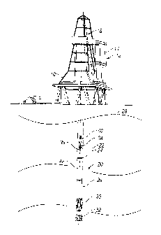
[0010] FIG. 1 schematically illustrates an elevation view of a drilling system
utilizing downhole depth measurement in accordance with one embodiment of
the present disclosure;
3
CA 02711442 2010-07-05
WO 2009/088915 PCT/US2008/088617
[0011] FIG. 2 is a flow chart illustrating one embodiment of a method for
operating an MWD system while tripping;
[0012] FIG. 3 illustrates a wellbore trajectory having discrete survey points;
and
[0013] FIG. 4 illustrates one embodiment of a survey tool made in
accordance with the present disclosure that traverses a wellbore under the
effect of gravity.
DETAILED DESCRIPTION OF THE DISCLOSURE
[0014] The present disclosure relates to devices and methods for self-
initiated or automated activation of downhole sensors while tripping into or
out of a wellbore. The present disclosure is susceptible to embodiments of
different forms. There are shown in the drawings, and herein will be
described in detail, specific embodiments of the present disclosure with
the understanding that the present disclosure is to be considered an
exemplification of the principles of the disclosure, and is not intended to
limit the disclosure to that illustrated and described herein. Further, while
embodiments may be described as having one or more features or a
combination of two or more features, such a feature or a combination of
features should not be construed as essential unless expressly stated as
essential.
[0015] Referring initially to Fig. 1, there is shown a conventional drilling
tower 10 for performing one or more operations related to the construction,
logging, completion or work-over of a hydrocarbon producing well. While a
land well is shown, the tower or rig can be situated on a drill ship or
another suitable surface workstation such as a floating platform or a semi-
submersible for offshore wells. The tower 10 includes a stock 12 of
tubular members generally referred to as drill string 20 segments 14,
which are typically of the same and predetermined length. The tubulars 14
can be formed partially or fully of drill pipe, metal or composite coiled
tubing, liner, casing or other known members. Additionally, the tubulars 14
4
CA 02711442 2010-07-05
WO 2009/088915
PCT/US2008/088617
can include a one way or bi- directional communication link utilizing data
and power transmission carriers such fluid conduits, fiber optics, and metal
conductors. The tubulars 14 are taken from the rod stock 12 by means of
a hoist or other handling device 18 and are joined together to become
component parts of the drill string 20. In embodiments, the tubular 14 may
be "stands." As is known, a stand may include a plurality of pipe joints
(e.g., three joints). At the bottom of the drill string 20 is a bottomhole
assembly (BHA) 22 illustrated diagrammatically in the broken-away part 24
that is adapted to form a wellbore 26 in the underground formation 28. The
BHA includes a housing 30 and a drive motor (not shown) that rotates a
drill bit 32.
[0016] The BHA 22 includes hardware and software to provide downhole
"intelligence" that processes measured and preprogrammed data and
writes the results to an on-board memory and/or transmits the results to
the surface. In one embodiment, a processor 36 disposed in the housing
30 is operatively coupled to one or more downhole sensors (discussed
below) that supply measurements for selected parameters of interest
including BHA or drill string 20 orientation, formation parameters, and
borehole parameters. The BHA can utilize a downhole power source such
as a battery (not shown), power transmitted from the surface via suitable
conductors, a downhole power generator such as a turbine or other
suitable power source. The processor 36 may include a memory module
38 to which data may be written and may be programmed with instructions
that evaluate and process measured parameters.
[0017] In embodiments, the BHA 22 may include sensors, generally
referenced with numeral 40 that, in part, measures acceleration in the x-
axis, y-axis, and z-axis directions. For convenience, the x-axis and y-axis
directions describe movement orthogonal to the longitudinal axis of the drill
string 20, and the z-axis direction describes movement parallel to the
longitudinal axis of the drill string 20. In one suitable arrangement, the
package uses a two axis gyro and three accelerometers to provide the
necessary data for orientation in a magnetic environment. One such
5
CA 02711442 2010-07-05
WO 2009/088915
PCT/US2008/088617
package or module, GYROTRAK, is made by BAKER HUGHES
INCORPORATED. Additionally, a magnetometer, which measures the
strength or direction of the Earth's magnetic, can be used when the BHA
22 is outside of the magnetic environment, i.e., in open hole. Other
instruments include mechanical devices such as plumb bobs and
electronic equipment such as magnetic directional survey equipment.
These sensors and instruments may provide measurements for
determining coordinates and positions; i.e., north, east and vertical, of the
BHA 22 in the wellbore. As used herein the term "north" refers to both
magnetic north and geographic north.
[0018] The BHA 22 may also include a measurement-while-drilling system
("MWD") 42 that may include one or more sensors or tools for evaluating
one or more parameters for the formation being drilled. Such sensors may
include electromagnetic propagation sensors for measuring the resistivity,
dielectric constant, or water saturation of the formation, nuclear sensors for
determining the porosity of the formation and acoustic sensors to
determine the formation acoustic velocity and porosity. Other downhole
sensors that have been used include sensors for determining the formation
density and permeability. The BHA may also include pressure sensors,
temperature sensors, gamma ray devices, acoustic and resistivity devices
for determining bed boundaries, and nuclear magnetic resonance ("NMR")
sensors for providing direct measurement for water saturation porosity and
indirect measurements for permeability and other formation parameters of
interest. As noted previously, the BHA may also include devices to
determine the BHA inclination and azimuth and devices that aid in
orienting the drill bit in a particular direction. In embodiments, the BHA 22
may be configured to measure one or more parameters of interest, write
data indicative of the measured parameter(s) to memory, and / or
periodically transmit some or all of the data to the surface.
6
CA 02711442 2010-07-05
WO 2009/088915
PCT/US2008/088617
[0019] It should be understood that the BHA 22 is merely representative of
wellbore tooling and equipment that may utilize the teachings of the
present disclosure.
[0020] In one operating mode, the processor 36 may be programmed to
acquire data using the MWD system 42 while the BHA 22 is drilling the
wellbore. The processor 36 may operate the sensors as needed to
acquire measurements and record those measurements to memory.
Additionally, the processor 36 may be programmed to periodically transmit
measured data to the surface during drilling, during specified events and /
or in response to a communication downlinks. In embodiments, a mud
pulse telemetry system may be used to transmit uplinks and downlinks.
[0021] In another mode of operation, the processor 36 may be
programmed to automatically acquire data using the MWD system 42 while
the BHA 22 is tripped out of the wellbore. Periodically, the drill string 20
may be pulled out of the wellbore to replace a worn drill bit, repair or
replace equipment, to perform a completion operation, etc. Typically,
during tripping out of the wellbore, high pressure drilling fluid is not
circulated in the wellbore. Thus, mud pulse based telemetry may not be
available to transmit communication downhole to control operation of the
MWD system 42 or transmit data uphole. In such instances where the
BHA 22 is being tripped out of the wellbore, the processor 36 may be
programmed to utilize data from one or more sensors to autonomously
control operation of the MWD system 42 in a manner that captures MWD
system 42 measurements without wasting memory space and / or battery
capacity. Exemplary embodiments are discussed below.
[0022] In one embodiment, the processor 36 may be programmed to
periodically or continuously process sensor data to determine whether a
tripping operation has commenced or is under way. For example, the
processor 36 may be programmed to detect changes in downhole certain
7
CA 02711442 2010-07-05
WO 2009/088915
PCT/US2008/088617
certain operating characteristics that would indicate the cessation of
normal drilling and to detect certain other operating characteristics that
indicate the beginning of tripping the drill string 20 out of the wellbore.
[0023] Referring now to Figs. 1 and 2, in one illustrative method 50, the
processor 46 at step 52 continuously monitors sensor measurements for
conditions associated with the stopping of pump operation and the
stopping of rotation of the drill string 20. Suitable sensors for such
monitoring include, but are not limited to, sensors such as accelerometers,
magnetometers and gyroscopes. For example, the processor 46 may be
programmed to perform fast Fourier transforms (FFT) on the
accelerometer measurements to determine whether a pump fundamental
frequency, ordinarily between 0.3 to 4 Hz, is present and is above a
predetermined threshold. Detection of such frequencies indicates
operation of the surface pumps. Magnetometers readings may give an
indication that the drill string 20 is rotating. Also,
accelerometers
measurements give an indication that the drill string is moving axially or
laterally. All of these conditions, if present, would indicate that the BHA 22
is in a drilling operating mode.
[0024] At step 54, the processor 46 may determine that one or more
sensor measurements are not consistent with that of the drilling mode of
operation. For instance, the processor 46 may receive sensor
measurements that indicate the cessation of pump operation, the
cessation of rotation of the drill string 20, and / or the reduction in axial
or
lateral movement of the drill string 20. The absence a pump operating
frequency may indicate that the surface pumps have stopped operating;
e.g., the FFT computations may indicate that pump fundamental
frequencies are not present in the drill string 20. The processor 46 may be
programmed to not only monitor confirm the cessation of pump operation
for a predetermined time period (e.g., thirty seconds). Axial and/or z axis
accelerometers may provide measurements that indicate no movement of
the drill string 20 for a predetermined time period or an upward motion.
Additionally, the sequence in which these events are detected may also be
8
CA 02711442 2010-07-05
WO 2009/088915
PCT/US2008/088617
utilized to determine whether a tripping operation may be imminent; e.g., a
reduction in axial movement, followed by no drill string rotation, followed by
no pump operation. That is, the processor 46 may be programmed to no
only monitor downhole parameters, but also the order or sequence in
which changes to those parameters occur. The processor 46 may use a
quiescent average value, an average value for the uphole direction, and /
or integrated depth motion for the uphole direction, in evaluating or
characterizing these accelerometer measurements. It will be appreciated
that, because variances in the magnitude of vibration of motion can occur
during normal drilling operations, standard deviations may be applied for
the output of these sensors to determine whether the measurements are
within a range associated with drilling operations or are indicative of an
interruption in drilling operation. It should be understood that these listed
parameters and thresholds are merely illustrative of the types of
parameters and thresholds that may be utilized to determine whether a
drilling mode of operation exists. For example, pressure sensors may also
be utilized to detect changes in fluid pressure that may indicate a change
in operating modes.
[0025] At step 56, the processor 46 may perform additional evaluations to
confirm the start of the tripping operation. For example, the processor 46
may re-evaluate axial accelerometer measurements to determine whether
drill string is, in fact, moving in an uphole direction. Additionally, the
processor 46 may utilize accelerometer measurements to identify a
sequence of movements that indicate that stands or joints are being
removed from the drill string 20; e.g., uphole movement of the drill string,
limited uphold and downhole movement, a quiet period, limited uphold and
downhole movement, uphold movement of the drill string, etc. In
embodiments, the processor 46 may utilize one or more databases (not
shown) to assist in determining whether the BHA 22 is in a tripping mode.
For purposes of this disclosure, the point at which the drill string 20 is
being tripped out of the wellbore may be considered the initiation of any
activity or action, including preparatory actions such as stopping drill
string
9
CA 02711442 2010-07-05
WO 2009/088915
PCT/US2008/088617
rotation and stopping the pumping of drilling fluid, that are typically taken
prior to actually pulling the drill string 20 out of the wellbore. That is,
the
tripping mode may begin well before the drill string 20 is moved axially
uphole. The databases may include data relating to the successive depths
of collars along a well casing or survey data relating to the thickness of
particular geological layers in a formation.
Generally speaking, the
measured parameters may relate to human made features such as
wellbore tooling / equipment and wellbore geometry or naturally occurring
features such as formation lithology. One or more sensors may provide
the downhole processor 36 with measurements that may be used to query
the databases to confirm that the BHA 22 is traveling in a particular
direction (e.g., uphole).
[0026] Once measurements and the values of any computations using
such measurements meet predetermined values, the processor 46 may
initiate operation of the MWD system 42 at step 58. In arrangements, the
processor 46 may operate the MWD system 42 by energizing one or more
directional and formation evaluation sensors. For example, a gyroscopic
sensor may be continuously energized to detect motionless periods
between stands of pipe and to make a gyrocompass survey during such
motionless periods and record the survey results to memory. The
processor 46 may be programmed to energize and de-energize the
sensors as needed or keeps the sensors continuously energized.
Maintaining a continuous powered sensor may reduce transients
associated with a powering up condition that would otherwise affect sensor
accuracy and reduce the total time required to obtain a survey.
[0027] In arrangements, the processor 46 may be programmed to
terminate operation of the MWD system 42 at step 60. In some
arrangements, the processor 46 may continually monitor sensor
measurements to detect events associated with a disruption of the tripping
operation. For example, the processor 46 may detect that the surface
pumps have been turned on. Also, in arrangements, the processor 46 may
terminate operation of the MWD system 42 in response to a predefined
CA 02711442 2010-07-05
WO 2009/088915 PCT/US2008/088617
"stop" signal applied at the surface by an operator on the rig floor. For
example, a magnetic rotation simulator or a vibrating pump simulator may
transmit a signal that may be detected by the sensors of the MWD system
42. Any of these methods may be utilized to have the processor 46 exit the
acquisition of survey data in the tripping mode of operation.
[0028] Referring now to Figs. 1 and 3, there is shown a wellbore 26 drilled
in an earthen formation 49 by a BHA 22. The BHA 22 is shown at position
S1', the position at which drilling is terminated. As the BHA 22 is tripped
out of the wellbore, drill string motion is periodically interrupted to remove
lengths of pipe 14 from the drill string 20. Exemplary stopping positions
are labeled Sl, S2, S3, Si, and Sn, for convenience. Initially, at position
Sl,
the processor 46, based on the sensor measurements in the BHA 22,
determines that drilling has stopped and initiates limited or full operation
of
the MWD system 42. In one mode of operation, the MWD system 42
surveys the formation as the BHA 22 moves from stopping point to
stopping point; e.g., S1 to S2. At each point SI, the processor 36 initiates a
directional survey using the on-board direction sensors 40. These sensors
40 can be used to determine north, east, and inclination of the BHA 22.
The survey data may then be associated or correlated with the determined
depth at each location Si. These "snapshot" survey stations with their
time-of-day data in memory are written to the onboard memory module 38
and/or transmitted to the surface.
[0029] From the above, it should be appreciated that a method of
surveying has been described wherein, while the pipe is not moving, a
downhole processor performs depth measurement calculations and
initiates a static orientation survey station. In casing, the surveys use a
gyroscopic survey instrument such as the GYROTRAK tool whereas in
open hole a magnetometer may be utilized. The processor computes
incremental north, east, and down displacements for the BHA course
length based on the inclination and azimuth computed at the beginning
and the end of the tubular joint.
Thereafter, a summation of the
incremental north, east and down displacements produces a set of present
11
CA 02711442 2010-07-05
WO 2009/088915
PCT/US2008/088617
total displacement figures for the BHA. The calculations can also be used
to determine other values such as true vertical depth. The processor
stores the accumulated displacements in the memory module in the
downhole MWD/Survey tool.
[0030] It should be understood that the teachings of the present disclosure
are not limited to tooling conveyed by rigid carriers such as drill strings,
such as that shown in Fig. 1. In embodiments, the above-described
methods and devices may be employed on non-rigid carriers such as slick
lines. In still other embodiments, the above-described methods and
devices may be used in connection with drop survey devices that are
released into the wellbore.
[0031] The above-described methods and devices in certain embodiments
may be employed with devices that take substantially continuous survey
measurements of the wellbore. In contrast to discrete intervals for takings
surveys, as described in connection with Fig. 3, the processor 36 (Fig. 1)
may continuously obtain directional survey data using the on-board
direction sensors 40. This survey data with their time-of-day data in
memory may be written to the onboard memory module 38 and/or
transmitted to the surface. Also, such an arrangement may be used
tooling conveyed with a non-rigid carrier (slickline) or tooling dropped into
a
wellbore, i.e., a drop survey tool. The wellbore tool may also be conveyed
by an autonomous wellbore drilling tool such as a tractor device or drilling
machine.
[0032] Referring now to Fig. 4, there is shown a drop tool 80 that may be
used to survey a formation 82. In one embodiment, the drop tool 80 free
falls within a bore of a tubing 84, which may be a part of the drill string 20
(Fig. 1), that is positioned in a drilled wellbore 86. During descent, the
drop tool 80 may perform surveys of the wellbore 86. The drop tool 80
may be configured to land on a suitable receiving device (not shown) in the
drill string 20 (Fig. 1). Thereafter, while the drill string 20 (Fig. 1) is
pulled
out of the wellbore 86, the drop tool 80 may perform surveys of the
12
CA 02711442 2010-07-05
WO 2009/088915 PCT/US2008/088617
wellbore 86. In one embodiment, the drop tool 80 may include a survey
tool 88 that includes any of the previously described sensors, such a
directional survey sensors and formation evaluation sensors. The drop
tool 80 may also include a processor 90, a memory 92, a battery 94, and a
clock 96. In a manner previously discussed, the processor 90 may be
programmed to control operation of the survey tool 88 as a function of the
movement of the drop tool 80. In some embodiments, the sensors of the
survey tool 88 may be utilized to determine whether a tripping operation is
imminent or is occurring. In other embodiments, a separate sensor 98
may be used by the processor 88 for making such determinations. Such
an arrangement may be advantageous, for example, if the separate sensor
96 can be configured to impose a lower power drain on the battery 94 that
the survey tool 88.
[0033] Thus, it should be appreciated that what has been disclosed
includes at least a method for surveying a formation having a wellbore.
This method may include conveying a survey instrument into the wellbore,
measuring a parameter of interest relating to a wellbore tubular in the
wellbore, and operating the survey instrument after the measured
parameter of interest indicates that the wellbore tubular is being tripped out
of the wellbore. The parameter of interest may include acceleration and /
or rotational speed. The survey instrument(s) may be a gyroscopic survey
instrument, a magnetometer, an accelerometer, a plumb bob, and / or a
magnetic directional survey instrument. The survey instrument may be
operated to take a survey, which may include measuring values for
azimuth and inclination. The survey may be performed at a plurality of
discrete locations using the survey instrument. The method may include
operating the survey instrument after determining that: the wellbore tubular
has stopped rotating, no fluid is being pumped along a bore of the wellbore
tubular, and / or the wellbore tubular is being moved axially. Also, the
method may include measuring a plurality of parameters of interest and
operating the survey instrument after detecting a change in values of the
plurality of parameters of interest. In aspects, the method may include
13
CA 02711442 2010-07-05
WO 2009/088915
PCT/US2008/088617
determining a sequence for the changes in values in the plurality of
parameters of interest, and operating the survey instrument after the
sequence is determined to correspond to a predetermined or selected
sequence.
[0034] It should also be appreciated that what has been disclosed includes
at least a system for surveying a formation having a wellbore. The system
may include a wellbore tubular; a survey instrument positioned on the
wellbore tubular; a sensor positioned on the tubular that measures a
parameter of interest relating to a wellbore tubular in the wellbore; and a
processor coupled to and receiving data from the sensor. The processor
may include executable instructions for operating the survey instrument
after the data for the sensor interest indicates that the wellbore tubular is
being tripped out of the wellbore.
[0035] It should be appreciated that what has been disclosed includes at
least a computer-readable medium accessible to a processor. The
computer-readable medium may include instructions that enable the
processor to determine whether or not a wellbore tubular is being tripped
out of the wellbore based on at least one measure parameter of interest
relating to the wellbore tubular and which enable the process to operate a
survey response upon determining that the wellbore tubular is being
tripped out of the wellbore. The medium may utilize least one of: (i) a
ROM, (ii) an EPROM, (iii) an EEPROM, (iv) a flash memory, and (v) an
optical disk.
[0036] While the foregoing disclosure is directed to the preferred
embodiments of the disclosure, various modifications will be apparent to
those skilled in the art. It is intended that all variations within the scope
of
the appended claims be embraced by the foregoing disclosure.
14