Note : Les descriptions sont présentées dans la langue officielle dans laquelle elles ont été soumises.
CA 02713340 2010-07-22
WO 2009/132678 PCT/EP2008/003707
1
NAVIGATION DEVICE AND METHOD
Field of the Invention
This invention relates to navigation devices and to methods of selecting a
radio
station. Illustrative embodiments of the invention relate to portable
navigation devices
(so-called PNDs), in particular PNDs that include Global Positioning System
(GPS)
signal reception and processing functionality. Other embodiments relate, more
generally, to any type of processing device that is configured to execute
navigation
software so as to provide route planning, and preferably also navigation,
functionality.
Background to the Invention
Portable navigation devices (PNDs) that include GPS (Global Positioning
System) signal reception and processing functionality are well known and are
widely
employed as in-car or other vehicle navigation systems.
In general terms, a modern PND comprises a processor, memory (at least one of
volatile and non-volatile, and commonly both), and map data stored within said
memory.
The processor and memory cooperate to provide an execution environment in
which a
software operating system may be established, and additionally it is
commonplace for
one or more additional software programs to be provided to enable the
functionality of
the PND to be controlled, and to provide various other functions.
Typically these devices further comprise one or more input interfaces that
allow a
user to interact with and control the device, and one or more output
interfaces by means
of which information may be relayed to the user. Illustrative examples of
output
interfaces include a visual display and a speaker for audible output.
Illustrative
examples of input interfaces include one or more physical buttons to control
on/off
operation or other features of the device (which buttons need not necessarily
be on the
device itself but could be on a steering wheel if the device is built into a
vehicle), and a
microphone for detecting user speech. In a particularly preferred arrangement
the
output interface display may be configured as a touch sensitive display (by
means of a
touch sensitive overlay or otherwise) to additionally provide an input
interface by means
of which a user can operate the device by touch.
Devices of this type will also often include one or more physical connector
interfaces by means of which power and optionally data signals can be
transmitted to
and received from the device, and optionally one or more wireless
transmitters/receivers
to allow communication over cellular telecommunications and other signal and
data
networks, for example Wi-Fi, Wi-Max GSM and the like.
CA 02713340 2010-07-22
WO 2009/132678 PCT/EP2008/003707
2
PND devices of this type also include a GPS antenna by means of which
satellite-broadcast signals, including location data, can be received and
subsequently
processed to determine a current location of the device.
The PND device may also include electronic gyroscopes and accelerometers
which produce signals that can be processed to determine the current angular
and linear
acceleration, and in turn, and in conjunction with location information
derived from the
GPS signal, velocity and relative displacement of the device and thus the
vehicle in
which it is mounted. Typically such features are most commonly provided in in-
vehicle
navigation systems, but may also be provided in PND devices if it is expedient
to do so.
The utility of such PNDs is manifested primarily in their ability to determine
a
route between a first location (typically a start or current location) and a
second location
(typically a destination). These locations can be input by a user of the
device, by any of
a wide variety of different methods, for example by postcode, street name and
house
number, previously stored "well known" destinations (such as famous locations,
municipal locations (such as sports grounds or swimming baths) or other points
of
interest), and favourite or recently visited destinations.
Typically, the PND is enabled by software for computing a "best" or "optimum"
route between the start and destination address locations from the map data. A
"best" or
"optimum" route is determined on the basis of predetermined criteria and need
not
necessarily be the fastest or shortest route. The selection of the route along
which to
guide the driver can be very sophisticated, and the selected route may take
into account
existing, predicted and dynamically and/or wirelessly received traffic and
road
information, historical information about road speeds, and the driver's own
preferences
for the factors determining road choice (for example the driver may specify
that the route
should not include motorways or toll roads).
In addition, the device may continually monitor road and traffic conditions,
and
offer to or choose to change the route over which the remainder of the journey
is to be
made due to changed conditions. Real time traffic monitoring systems, based on
various
technologies (e.g. mobile phone data exchanges, fixed cameras, GPS fleet
tracking) are
being used to identify traffic delays and to feed the information into
notification systems.
PNDs of this type may typically be mounted on the dashboard or windscreen of a
vehicle, but may also be formed as part of an on-board computer of the vehicle
radio or
indeed as part of the control system of the vehicle itself. The navigation
device may also
be part of a hand-held system, such as a PDA (Portable Digital Assistant) a
media
player, a mobile phone or the like, and in these cases, the normal
functionality of the
hand-held system is extended by means of the installation of software on the
device to
CA 02713340 2010-07-22
WO 2009/132678 PCT/EP2008/003707
3
perform both route calculation and navigation along a calculated route.
Route planning and navigation functionality may also be provided by a desktop
or
mobile computing resource running appropriate software. For example, the Royal
Automobile Club (RAC) provides an on-line route planning and navigation
facility at
http://www.rac.co.uk, which facility allows a user to enter a start point and
a destination
whereupon the server to which the user's PC is connected calculates a route
(aspects of
which may be user specified), generates a map, and generates a set of
exhaustive
navigation instructions for guiding the user from the selected start point to
the selected
destination. The facility also provides for pseudo three-dimensional rendering
of a
calculated route, and route preview functionality which simulates a user
travelling along
the route and thereby provides the user with a preview of the calculated
route.
In the context of a PND, once a route has been calculated, the user interacts
with
the navigation device to select the desired calculated route, optionally from
a list of
proposed routes. Optionally, the user may intervene in, or guide the route
selection
process, for example by specifying that certain routes, roads, locations or
criteria are to
be avoided or are mandatory for a particular journey. The route calculation
aspect of the
PND forms one primary function, and navigation along such a route is another
primary
function.
During navigation along a calculated route, it is usual for such PNDs to
provide
visual and/or audible instructions to guide the user along a chosen route to
the end of
that route, i.e. the desired destination. It is also usual for PNDs to display
map
information on-screen during the navigation, such information regularly being
updated
on-screen so that the map information displayed is representative of the
current location
of the device, and thus of the user or user's vehicle if the device is being
used for in-
vehicle navigation.
An icon displayed on-screen typically denotes the current device location, and
is
centred with the map information of current and surrounding roads in the
vicinity of the
current device location and other map features also being displayed.
Additionally,
navigation information may be displayed, optionally in a status bar above,
below or to
one side of the displayed map information, examples of navigation information
include a
distance to the next deviation from the current road required to be taken by
the user, the
nature of that deviation possibly being represented by a further icon
suggestive of the
particular type of deviation, for example a left or right turn. The navigation
function also
determines the content, duration and timing of audible instructions by means
of which
the user can be guided along the route. As can be appreciated a simple
instruction such
as "turn left in 100 m" requires significant processing and analysis. As
previously
CA 02713340 2010-07-22
WO 2009/132678 PCT/EP2008/003707
4
mentioned, user interaction with the device may be by a touch screen, or
additionally or
alternately by steering column mounted remote control, by voice activation or
by any
other suitable method.
A further important function provided by the device is automatic route re-
calculation in the event that: a user deviates from the previously calculated
route during
navigation (either by accident or intentionally); real-time traffic conditions
dictate that an
alternative route would be more expedient and the device is suitably enabled
to
recognize such conditions automatically, or if a user actively causes the
device to
perform route re-calculation for any reason.
It is also known to allow a route to be calculated with user defined criteria;
for
example, the user may prefer a scenic route to be calculated by the device, or
may wish
to avoid any roads on which traffic congestion is likely, expected or
currently prevailing.
The device software would then calculate various routes and weigh more
favourably
those that include along their route the highest number of points of interest
(known as
POls) tagged as being for example of scenic beauty, or, using stored
information
indicative of prevailing traffic conditions on particular roads, order the
calculated routes
in terms of a level of likely congestion or delay on account thereof. Other
POI-based and
traffic information-based route calculation and navigation criteria are also
possible.
Although the route calculation and navigation functions are fundamental to the
overall utility of PNDs, it is possible to use the device purely for
information display, or
"free-driving", in which only map information relevant to the current device
location is
displayed, and in which no route has been calculated and no navigation is
currently
being performed by the device. Such a mode of operation is often applicable
when the
user already knows the route along which it is desired to travel and does not
require
navigation assistance.
Devices of the type described above, for example the 720T model manufactured
and supplied by TomTom International B.V., provide a reliable means for
enabling users
to navigate from one position to another.
Devices such as those described above may include facilities for FM radio
station
broadcast reception. A device may include a receiver that is tuned to receive
a
particular radio station (the current radio station). If the device notices
that the received
signal of the current radio station drops below a predetermined level, the
device stops
receiving the current radio station and uses the receiver to search for an
alternative radio
station. This causes a break in reception of a radio station. Also, there may
be a
noticeable drop in quality of the current radio station.
Other devices may include two receivers/tuners, whereby one receiver receives
CA 02713340 2010-07-22
WO 2009/132678 PCT/EP2008/003707
the current radio station while the other searches for an alternative. However
this is an
expensive approach as two receivers/tuners are required.
It is an aim of embodiments of the present invention to at least mitigate one
or
more of the problems of the prior art.
5
Summary of the Invention
In pursuit of this aim, a presently preferred embodiment of the present
invention
provides a navigation device comprising a location determining device (250)
for
determining a current location of the navigation device; wherein the
navigation device is
arranged to select a radio station based on the current location of the
navigation device.
Thus, selection of the radio station based on current location can be used,
for
example, to select a radio station that has or may have the strongest signal
without the
use of a second receiver and without the need to stop reception of a current
radio station
while an alternative is sought. Furthermore, the signal level of a currently
received radio
station does not have to drop below a predetermined level before an
alternative is
sought, and therefore degradation in reception quality associated with such an
approach
may be avoided.
The radio station may be selected based on the location of a transmitter that
is
transmitting the radio station. For example, the radio station selected may be
transmitted by a transmitter that is closest to the current location. Such a
radio station
may be received by the navigation device with a signal strength and/or quality
that is
higher than radio stations that are transmitted by transmitters that are
further away.
Another embodiment of the present invention provides a method of selecting a
radio station, comprising determining a current location; and selecting a
radio station
based on the current location.
Yet another embodiment of the present invention provides computer software
comprising one or more software modules operable, when executed in an
execution
environment, to cause a processor (210) to determine a current location; and
select a
radio station based on the current location.
Advantages of these embodiments are set out hereafter, and further details and
features of each of these embodiments are defined in the accompanying
dependent
claims and elsewhere in the following detailed description.
Brief Description of the Drawings
Various aspects of the teachings of the present invention, and arrangements
embodying those teachings, will hereafter be described by way of illustrative
example
CA 02713340 2010-07-22
WO 2009/132678 PCT/EP2008/003707
6
with reference to the accompanying drawings, in which:
Fig. 1 is a schematic illustration of a Global Positioning System (GPS);
Fig. 2 is a schematic illustration of electronic components arranged to
provide a
navigation device;
Fig. 3 is a schematic illustration of the manner in which a navigation device
may
receive information over a wireless communication channel;
Figs. 4A and 4B are illustrative perspective views of a navigation device;
Figs. 5a to 5i aew illustrative screenshots from a TomTom 720T PND for a
destination input process;
Fig. 6 is an illustrative screenshot from a TomTom 720T depicting a start
location
for an illustrative calculated route;
Fig. 7 is an illustrative example of the position of a navigation deice with
respect
to two transmitters;
Fig. 8 is another illustrative example of the position of a navigation deice
with
respect to two transmitters; and
Fig. 9 is a schematic representation of the software employed by the
navigation
device.
Detailed Description of Preferred Embodiments
Preferred embodiments of the present invention will now be described with
particular reference to a PND. It should be remembered, however, that the
teachings of
the present invention are not limited to PNDs but are instead universally
applicable to
any type of processing device that is configured to execute navigation
software so as to
provide route planning and navigation functionality. It follows therefore that
in the
context of the present application, a navigation device is intended to include
(without
limitation) any type of route planning and navigation device, irrespective of
whether that
device is embodied as a PND, a navigation device built into a vehicle, or
indeed a
computing resource (such as a desktop or portable personal computer (PC),
mobile
telephone or portable digital assistant (PDA)) executing route planning and
navigation
software.
It will also be apparent from the following that the teachings of the present
invention even have utility in circumstances where a user is not seeking
instructions on
how to navigate from one point to another, but merely wishes to be provided
with a view
of and/or information on a given location. In such circumstances the
"destination"
location selected by the user need not have a corresponding start location
from which
the user wishes to start navigating, and as a consequence references herein to
the
CA 02713340 2010-07-22
WO 2009/132678 PCT/EP2008/003707
7
"destination" location or indeed to a "destination" view should not be
interpreted to mean
that the generation of a route is essential, that travelling to the
"destination" must occur,
or indeed that the presence of a destination requires the designation of a
corresponding
start location.
With the above provisos in mind, Fig. 1 illustrates an example view of Global
Positioning System (GPS), usable by navigation devices. Such systems are known
and
are used for a variety of purposes. In general, GPS is a satellite-radio based
navigation
system capable of determining continuous position, velocity, time, and in some
instances
direction information for an unlimited number of users. Formerly known as
NAVSTAR,
the GPS incorporates a plurality of satellites which orbit the earth in
extremely precise
orbits. Based on these precise orbits, GPS satellites can relay their location
to any
number of receiving units.
The GPS system is implemented when a device, specially equipped to receive
GPS data, begins scanning radio frequencies for GPS satellite signals. Upon
receiving
a radio signal from a GPS satellite, the device determines the precise
location of that
satellite via one of a plurality of different conventional methods. The device
will continue
scanning, in most instances, for signals until it has acquired at least three
different
satellite signals (noting that position is not normally, but can be,
determined with only
two signals using other triangulation techniques). Implementing geometric
triangulation,
the receiver utilizes the three known positions to determine its own two-
dimensional
position relative to the satellites. This can be done in a known manner.
Additionally,
acquiring a fourth satellite signal will allow the receiving device to
calculate its three
dimensional position by the same geometrical calculation in a known manner.
The
position and velocity data can be updated in real time on a continuous basis
by an
unlimited number of users.
As shown in Figure 1, the GPS system is denoted generally by reference
numeral 100. A plurality of satellites 120 are in orbit about the earth 124.
The orbit of
each satellite 120 is not necessarily synchronous with the orbits of other
satellites 120
and, in fact, is likely asynchronous., A GPS receiver 140 is shown receiving
spread
spectrum GPS satellite signals 160 from the various satellites 120.
The spread spectrum signals 160, continuously transmitted from each satellite
120, utilize a highly accurate frequency standard accomplished with an
extremely
accurate atomic clock. Each satellite 120, as part of its data signal
transmission 160,
transmits a data stream indicative of that particular satellite 120. It is
appreciated by
those skilled in the relevant art that the GPS receiver device 140 generally
acquires
spread spectrum GPS satellite signals 160 from at least three satellites 120
for the GPS
CA 02713340 2010-07-22
WO 2009/132678 PCT/EP2008/003707
8
receiver device 140 to calculate its two-dimensional position by
triangulation. Acquisition
of an additional signal, resulting in signals 160 from a total of four
satellites 120, permits
the GPS receiver device 140 to calculate its three-dimensional position in a
known
manner.
Figure 2 is an illustrative representation of electronic components of a
navigation
device 200 according to a preferred embodiment of the present invention, in
block
component format. It should be noted that the block diagram of the navigation
device
200 is not inclusive of all components of the navigation device, but is only
representative
of many example components.
The navigation device 200 is located within a housing (not shown). The housing
includes a processor 210 connected to an input device 220 and a display screen
240.
The input device 220 can include a keyboard device, voice input device, touch
panel
and/or any other known input device utilised to input information; and the
display screen
240 can include any type of display screen such as an LCD display, for
example. In a
particularly preferred arrangement the input device 220 and display screen 240
are
integrated into an integrated input and display device, including a touchpad
or
touchscreen input so that a user need only touch a portion of the display
screen 240 to
select one of a plurality of display choices or to activate one of a plurality
of virtual
buttons.
The navigation device may include an output device 260, for example an audible
output device (e.g. a loudspeaker). As output device 260 can produce audible
information for a user of the navigation device 200, it is should equally be
understood
that input device 240 can include a microphone and software for receiving
input voice
commands as well.
In the navigation device 200, processor 210 is operatively connected to and
set
to receive input information from input device 220 via a connection 225, and
operatively
connected to at least one of display screen 240 and output device 260, via
output
connections 245, to output information thereto. Further, the processor 210 is
operatively
connected to memory 230 via connection 235 and is further adapted to
receive/send
information from/to input/output (I/O) ports 270 via connection 275, wherein
the I/O port
270 is connectible to an I/O device 280 external to the navigation device 200.
The
external I/O device 280 may include, but is not limited to an external
listening device
such as an earpiece for example. The connection to I/O device 280 can further
be a
wired or wireless connection to any other external device such as a car stereo
unit for
hands-free operation and/or for voice activated operation for example, for
connection to
an ear piece or head phones, and/or for connection to a mobile phone for
example,
CA 02713340 2010-07-22
WO 2009/132678 PCT/EP2008/003707
9
wherein the mobile phone connection may be used to establish a data connection
between the navigation device 200 and the internet or any other network for
example,
and/or to establish a connection to a server via the internet or some other
network for
example.
The navigation device 200 of fig. 2 includes a radio antenna/receiver 285. The
radio antenna/receiver 285 may comprise a single device or may comprise a
separate
antenna and receiver, for example. Each of the antenna and receiver of the
radio
antenna/receiver 285 may be located internally to the navigation device 200,
or
externally via an appropriate connection (not shown). The radio
antenna/receiver 285
may be tuned to a particular frequency or station to receive a radio station
broadcast.
Where the radio station broadcast is a FM radio broadcast, for example, it may
include
an audio portion and a radio data system (RDS) portion. The navigation device
200 may
be arranged to receive and process one or both portions of the broadcast. For
example,
the navigation device may be arranged to play the audio portion through a
device such
as an earphone or speaker (not shown), and/or may be arranged to receive
dynamic
traffic information broadcast using RDS. Additionally or alternatively, the
radio
antenna/receiver 285 may include the capability to receive digital radio
broadcasts
(digital audio broadcasting, DAB).
Fig. 2 further illustrates an operative connection between the processor 210
and
an antenna/receiver 250 via connection 255, wherein the antenna/receiver 250
can be a
GPS antenna/receiver for example. It will be understood that the antenna and
receiver
designated by reference numeral 250 are combined schematically for
illustration, but
that the antenna and receiver may be separately located components, and that
the
antenna may be a GPS patch antenna or helical antenna for example.
Further, it will be understood by one of ordinary skill in the art that the
electronic
components shown in Fig. 2 are powered by power sources (not shown) in a
conventional manner. As will be understood by one of ordinary skill in the
art, different
configurations of the components shown in Fig. 2 are considered to be within
the scope
of the present application. For example, the components shown in Fig. 2 may be
in
communication with one another via wired and/or wireless connections and the
like.
Thus, the scope of the navigation device 200 of the present application
includes a
portable or handheld navigation device 200.
In addition, the portable or handheld navigation device 200 of Fig. 2 can be
connected or "docked" in a known manner to a vehicle such as a bicycle, a
motorbike, a
car or a boat for example. Such a navigation device 200 is then removable from
the
docked location for portable or handheld navigation use.
CA 02713340 2010-07-22
WO 2009/132678 PCT/EP2008/003707
Referring now to Fig. 3, the navigation device 200 may establish a "mobile" or
telecommunications network connection with a server 302 via a mobile device
(not
shown) (such as a mobile phone, PDA, and/or any device with mobile phone
technology)
establishing a digital connection (such as a digital connection via known
Bluetooth
5 technology for example). Thereafter, through its network service provider,
the mobile
device can establish a network connection (through the internet for example)
with a
server 302. As such, a "mobile" network connection is established between the
navigation device 200 (which can be, and often times is mobile as it travels
alone and/or
in a vehicle) and the server 302 to provide a "real-time" or at least very "up
to date"
10 gateway for information.
The establishing of the network connection between the mobile device (via a
service provider) and another device such as the server 302, using an internet
(such as
the World Wide Web) for example, can be done in a known manner. This can
include
use of TCP/IP layered protocol for example. The mobile device can utilize any
number
of communication standards such as CDMA, GSM, WAN, etc.
As such, an internet connection may be utilised which is achieved via data
connection, via a mobile phone or mobile phone technology within the
navigation device
200 for example. For this connection, an internet connection between the
server 302
and the navigation device 200 is established. This can be done, for example,
through a
mobile phone or other mobile device and a GPRS (General Packet Radio Service)-
connection (GPRS connection is a high-speed data connection for mobile devices
provided by telecom operators; GPRS is a method to connect to the internet).
The navigation device 200 can further complete a data connection with the
mobile device, and eventually with the internet and server 302, via existing
Bluetooth
technology for example, in a known manner, wherein the data protocol can
utilize any
number of standards, such as the GSRM, the Data Protocol Standard for the GSM
standard, for example.
The navigation device 200 may include its own mobile phone technology within
the navigation device 200 itself (including an antenna for example, or
optionally using
the internal antenna of the navigation device 200). The mobile phone
technology within
the navigation device 200 can include internal components as specified above,
and/or
can include an insertable card (e.g. Subscriber Identity Module or SIM card),
complete
with necessary mobile phone technology and/or an antenna for example. As such,
mobile phone technology within the navigation device 200 can similarly
establish a
network connection between the navigation device 200 and the server 302, via
the
internet for example, in a manner similar to that of any mobile device.
CA 02713340 2010-07-22
WO 2009/132678 PCT/EP2008/003707
11
For GRPS phone settings, a Bluetooth enabled navigation device may be used to
correctly work with the ever changing spectrum of mobile phone models,
manufacturers,
etc., model/manufacturer specific settings may be stored on the navigation
device 200
for example. The data stored for this information can be updated.
In Fig. 3 the navigation device 200 is depicted as being in communication with
the server 302 via a generic communications channel 318 that can be
implemented by
any of a number of different arrangements. The server 302 and a navigation
device 200
can communicate when a connection via communications channel 318 is
established
between the server 302 and the navigation device 200 (noting that such a
connection
can be a data connection via mobile device, a direct connection via personal
computer
via the internet, etc.).
The server 302 includes, in addition to other components which may not be
illustrated, a processor 304 operatively connected to a memory 306 and further
operatively connected, via a wired or wireless connection 314, to a mass data
storage
device 312. The processor 304 is further operatively connected to transmitter
308 and
receiver 310, to transmit and send information to and from navigation device
200 via
communications channel 318. The signals sent and received may include data,
communication, and/or other propagated signals. The transmitter 308 and
receiver 310
may be selected or designed according to the communications requirement and
communication technology used in the communication design for the navigation
system
200. Further, it should be noted that the functions of transmitter 308 and
receiver 310
may be combined into a signal transceiver.
Server 302 is further connected to (or includes) a mass storage device 312,
noting that the mass storage device 312 may be coupled to the server 302 via
communication link 314. The mass storage device 312 contains a store of
navigation
data and map information, and can again be a separate device from the server
302 or
can be incorporated into the server 302.
The navigation device 200 is adapted to communicate with the server 302
through communications channel 318, and includes processor, memory, etc. as
previously described with regard to Fig. 2, as well as transmitter 320 and
receiver 322 to
send and receive signals and/or data through the communications channel 318,
noting
that these devices can further be used to communicate with devices other than
server
302. Further, the transmitter 320 and receiver 322 are selected or designed
according
to communication requirements and communication technology used in the
communication design for the navigation device 200 and the functions of the
transmitter
320 and receiver 322 may be combined into a single transceiver.
CA 02713340 2010-07-22
WO 2009/132678 PCT/EP2008/003707
12
Software stored in server memory 306 provides instructions for the processor
304 and allows the server 302 to provide services to the navigation device
200. One
service provided by the server 302 involves processing requests from the
navigation
device 200 and transmitting navigation data from the mass data storage 312 to
the
navigation device 200. Another service provided by the server 302 includes
processing
the navigation data using various algorithms for a desired application and
sending the
results of these calculations to the navigation device 200.
The communication channel 318 generically represents the propagating medium
or path that connects the navigation device 200 and the server 302. Both the
server 302
and navigation device 200 include a transmitter for transmitting data through
the
communication channel and a receiver for receiving data that has been
transmitted
through the communication channel.
The communication channel 318 is not limited to a particular communication
technology. Additionally, the communication channel 318 is not limited to a
single
communication technology; that is, the channel 318 may include several
communication
links that use a variety of technology. For example, the communication channel
318 can
be adapted to provide a path for electrical, optical, and/or electromagnetic
communications, etc. As such, the communication channel 318 includes, but is
not
limited to, one or a combination of the following: electric circuits,
electrical conductors
such as wires and coaxial cables, fibre optic cables, converters, radio-
frequency (RF)
waves, the atmosphere, empty space, etc. Furthermore, the communication
channel
318 can include intermediate devices such as routers, repeaters, buffers,
transmitters,
and receivers, for example.
In one illustrative arrangement, the communication channel 318 includes
telephone and computer networks. Furthermore, the communication channel 318
may
be capable of accommodating wireless communication such as radio frequency,
microwave frequency, infrared communication, etc. Additionally, the
communication
channel 318 can accommodate satellite communication.
The communication signals transmitted through the communication channel 318
include, but are not limited to, signals as may be required or desired for
given
communication technology. For example, the signals may be adapted to be used
in
cellular communication technology such as Time Division Multiple Access
(TDMA),
Frequency Division Multiple Access (FDMA), Code Division Multiple Access
(CDMA),
Global System for Mobile Communications (GSM), etc. Both digital and analogue
signals can be transmitted through the communication channel 318. These
signals may
be modulated, encrypted and/or compressed signals as may be desirable for the
CA 02713340 2010-07-22
WO 2009/132678 PCT/EP2008/003707
13
communication technology.
The server 302 includes a remote server accessible by the navigation device
200
via a wireless channel. The server 302 may include a network server located on
a local
area network (LAN), wide area network (WAN), virtual private network (VPN),
etc.
The server 302 may include a personal computer such as a desktop or laptop
computer, and the communication channel 318 may be a cable connected between
the
personal computer and the navigation device 200. Alternatively, a personal
computer
may be connected between the navigation device 200 and the server 302 to
establish an
internet connection between the server 302 and the navigation device 200.
Alternatively, a mobile telephone or other handheld device may establish a
wireless
connection to the internet, for connecting the navigation device 200 to the
server 302 via
the internet.
The navigation device 200 may be provided with information from the server 302
via information downloads which may be periodically updated automatically or
upon a
user connecting navigation device 200 to the server 302 and/or may be more
dynamic
upon a more constant or frequent connection being made between the server 302
and
navigation device 200 via a wireless mobile connection device and TCP/IP
connection
for example. For many dynamic calculations, the processor 304 in the server
302 may
be used to handle the bulk of the processing needs, however, processor 210 of
navigation device 200 can also handle much processing and calculation,
oftentimes
independent of a connection to a server 302.
As indicated above in Fig. 2, a navigation device 200 includes a processor
210,
an input device 220, and a display screen 240. The input device 220 and
display screen
240 are integrated into an integrated input and display device to enable both
input of
information (via direct input, menu selection, etc.) and display of
information through a
touch panel screen, for example. Such a screen may be a touch input LCD
screen, for
example, as is well known to those of ordinary skill in the art. Further, the
navigation
device 200 can also include any additional input device 220 and/or any
additional output
device 241, such as audio input/output devices for example.
Figs 4A and 4B are perspective views of a navigation device 200. As shown in
Fig. 4A, the navigation device 200 may be a unit that includes an integrated
input and
display device 290 (a touch panel screen for example) and the other components
of fig.
2 (including but not limited to internal GPS receiver 250, microprocessor 210,
a power
supply, memory systems 230, etc.).
The navigation device 200 may sit on an arm 292, which itself may be secured
to
a vehicle dashboard/window/etc. using a suction cup 294. This arm 292 is one
example
CA 02713340 2010-07-22
WO 2009/132678 PCT/EP2008/003707
14
of a docking station to which the navigation device 200 can be docked.
As shown in Fig. 4B, the navigation device 200 can be docked or otherwise
connected to an arm 292 of the docking station by snap connecting the
navigation
device 292 to the arm 292 for example. The navigation device 200 may then be
rotatable on the arm 292, as shown by the arrow of Fig. 4B. To release the
connection
between the navigation device 200 and the docking station, a button on the
navigation
device 200 may be pressed, for example. Other equally suitable arrangements
for
coupling and decoupling the navigation device to a docking station are well
known to
persons of ordinary skill in the art.
Referring now to Figs. 5a to 5i there is depicted a series of screenshots from
a
TomTom 720T navigation device. This model of TomTom PND has a touchscreen
interface for displaying information to a user and for accepting input to the
device from
the user. The screenshots show an illustrative destination location input
process for a
user whose home location has been set to the offices in The Hague of the
European
Patent Office, and who wishes to navigate to a street address in Amsterdam,
The
Netherlands for which they know the street name and building number.
When this user switches on their TomTom PND, the device acquires a GPS fix
and calculates (in a known manner) the current location of the PND. The user
is then
presented, as shown in Fig. 5a, with a display 340 showing in pseudo three-
dimensions
the local environment 342 in which the PND is determined to be located, and in
a region
344 of the display 340 below the local environment a series of control and
status
messages.
By touching the display of the local environment 342, the PND switches to
display (as shown in Fig. 5b) a series of virtual buttons 346 by means of
which a user
can, inter alia, input a destination that they wish to navigate to.
By touching the "navigate to" virtual button 348, the PND switches to display
(as
shown in Fig. 5c) a plurality of virtual buttons that are each associated with
a different
category of selectable destinations. In this instance, the display shows a
"home" button
that if pressed would set the destination to the stored home location.
However, in this
instance as the user is already at their home location (namely the EPO's
offices in the
Hague) selecting this option would not cause a route to be generated. The
"favourite"
button, if pressed, reveals a list of destinations that the user has
previously stored in the
PND and if one of these destinations is then selected the destination for the
route to be
calculated is set to the selected previously stored destination. The "recent
destination"
button, if pressed, reveals a list of selectable destinations held in the
memory of the PND
and to which the user has recently navigated. Selection of one of the
destinations
CA 02713340 2010-07-22
WO 2009/132678 PCT/EP2008/003707
populating this list would set the destination location for this route to the
selected
(previously visited) location. The "point of interest" button, if pressed,
reveals a number
of options by means of which a user can opt to navigate to any of a plurality
of locations,
such as cash machines, petrol stations or tourist attractions for example,
that have been
5 pre-stored in the device as locations that a user of the device might want
to navigate to.
The "arrow" shaped virtual button opens a new menu of additional options, and
the
"address" button 350 commences a process by which the user can input the
street
address of the destination that they wish to navigate to.
Since the user, in this example, knows the street address of the destination
that
10 they wish to navigate to, it is assumed that this "address" button is
operated (by touching
the button displayed on the touchscreen), whereupon (as shown in Fig. 5d) the
user is
presented with a series of address input options - in particular for address
input by "city
centre", by "postcode", by "crossing or intersection" (for example a junction
of two roads)
and by "street and house number".
15 In this example the user knows the street address and house number of the
destination and hence selects the "street and house number" virtual button 352
whereupon the user is then presented, as shown in Fig. 5e, a prompt 354 to
enter the
name of the city that they wish to navigate to, a flag button 356 by means of
which the
user can select the country in which the desired city is located, and a
virtual keyboard
358 that may be operated by the user, if necessary, to input the name of the
destination
city. In this instance the user has previously navigated to locations in
Rijswijk and
Amsterdam, and the PND therefore additionally provides the user with a list
360 of
selectable cites.
The user in this instance wishes to navigate to Amsterdam, and on selection of
Amsterdam from the list 360 the PND displays, as shown in Fig. 5f, a virtual
keyboard
362 by means of which a user can input street names, a prompt 364 for entry of
a
streetname 364 and, in this instance, as the user has previously navigated to
a street in
Amsterdam, a list 366 of selectable streets in Amsterdam.
In this example the user wishes to return to the street, Rembrandtplein, that
they
have previously visited and so selects Rembrandtplein from the displayed list
366.
Once a street has been selected, the PND then displays a smaller virtual
keypad
368 and prompts the user, by means of prompt 370, to enter the number of the
house in
the selected street and city that they wish to navigate to. If the user has
previously
navigated to a house number in this street, then that number (as shown in Fig.
5g) is
initially shown. If, as in this instance, the user wishes to navigate to No.
35,
Rembrandtplein once again, then the user need only touch a "done" virtual
button 372
CA 02713340 2010-07-22
WO 2009/132678 PCT/EP2008/003707
16
displayed at the bottom right hand corner of the display. If the user should
wish to
navigate to a different house number in Rembrandtplein, then all they need do
is operate
the keypad 368 to input the appropriate house number.
Once the house number has been input, the user is asked in Fig. 5h, whether
they wish to arrive at a particular time. If the user should push the "yes"
button, then
functionality is invoked that estimates the time required to travel to the
destination and
advises the user when they should leave (or if they are running late, should
have left)
their current location in order to arrive at their destination on time. In
this instance the
user is not concerned about arriving at a particular time and hence selects
the "no"
virtual button.
Selecting the "no" button 374 causes the PND to calculate a route between the
current location and the selected destination and to display that route 376,
as shown in
Fig. 5i, on a relatively low magnification map that shows the entire route.
The user
provided with a "done" virtual button 378 which they can press to indicate
that they are
happy with the calculated route, a "find alternative" button 380 that the user
can press to
cause the PND to calculate another route to the selected destination, and a
"details"
button 382 that a user can press to reveal selectable options for the display
of more
detailed information concerning the currently displayed route 376.
In this instance it is assumed that the user is happy with the displayed
route, and
once the "done" button 378 has been pressed the user is presented, as shown in
Fig. 6,
with a pseudo three-dimensional view of the current, start, location for the
PND. The
display depicted in Fig. 6 is similar to that shown in Fig. 5a except that the
displayed
local environment 342 now includes a start location flag 384 and a waypoint
indicator
386 indicating the next manoeuvre (in this instance, a left hand turn). The
lower part of
the display has also changed and now displays the name of the street in which
the PND
is currently located, an icon 388 indicating the distance to and type of the
next
manoeuvre (from the current location of the PND), and a dynamic display 390 of
the
distance and time to the selected destination.
The user then commences their journey and the PND guides the user, in a
known manner, by updating the map in accordance with determined changes in PND
location, and by providing the user with visual and, optionally, audible
navigation
instructions.
As described above, a navigation device 200 (such as, for example, a PND or a
vehicle-mounted navigation device) may include or be connected to a radio
antenna/receiver 285 for receiving radio station broadcasts, for example FM
and/or
digital radio stations. Typically, the antenna/receiver 285 can only receive a
single radio
CA 02713340 2010-07-22
WO 2009/132678 PCT/EP2008/003707
17
station, and can be controlled to receive other radio stations if desired.
Embodiments of the invention select a radio station to receive based on the
current location of the navigation device 200 as indicated by the GPS
antenna/receiver
250 (hereinafter called the GPS device 250). The current position of the
navigation
device 200 is used to decide which radio station to receive. For example, the
locations
of transmitters of radio stations are considered. Embodiments of the invention
may
select a transmitter based on the current location of the navigation device,
and may then
select a radio station transmitted by the selected transmitter.
For example, embodiments of the invention select a transmitter and radio
station
based on the current location of the navigation device 200 so that it is
likely that a radio
station with the strongest received signal is selected. The navigation device
200 may
then control the radio antenna/receiver 285 to receive the selected radio
station
transmitted by the selected transmitter. In embodiments of the invention, the
transmitter
closest to the navigation device is selected.
Figure 7 shows an example of embodiments of the invention. A portable
navigation device 200 is receiving a radio station broadcast that is
transmitted by a first
transmitter 700. The portable navigation device 200 is a distance x from the
first
transmitter 700 and a distance y from a second transmitter 702. The distance x
is less
than the distance y, i.e. the navigation device 200 is closer to the first
transmitter 700
than the second transmitter 702. Therefore, the navigation device 200 does not
change
the received radio station to one that is transmitted by the second
transmitter 702. The
distances x and y may be, for example, straight line distances and may or may
not take
into account differences in altitude between the navigation device 200 and the
respective
transmitters.
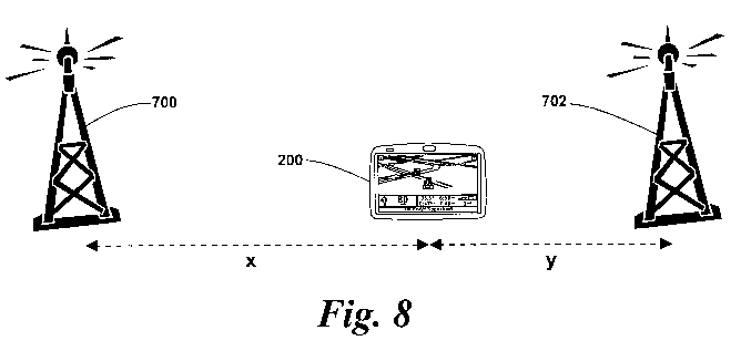
Figure 8 shows the navigation device 200 after it has travelled some distance
along a journey, for example along a route calculated by the navigation device
200. At
this time, the distance x to the first transmitter 700 is greater than the
distance y to the
second transmitter, i.e. the navigation device 200 is closer to the second
transmitter 702
than the first transmitter 700. Therefore, the navigation device selects a
radio station
that is transmitted by the second transmitter 702, and controls the radio
antenna/receiver
285 such that the selected radio station is received. For example, where the
radio
station is a FM radio station, the antenna/receiver 285 is tuned to the
frequency of the
selected radio station. Thus, there is no need for a second tuner, and a new
radio
station is selected with little or no break in reception of a radio station.
Also, there is no
requirement for waiting until the signal strength and/or quality of a received
radio station
broadcast falls below a predetermined level before a new station is selected.
CA 02713340 2010-07-22
WO 2009/132678 PCT/EP2008/003707
18
The navigation device 200 may select a radio station based on the current
location of the device using, for example, a list of a plurality of
transmitters and the radio
stations transmitted by those transmitters. The list may be stored, for
example, in the
memory 230 of the navigation device 200. Therefore, for example, the
navigation device
may periodically determine the distance to some or all of the transmitters in
the list and
select a transmitter based on these distances (for example, the closest
transmitter is
selected). Then, the navigation device 200 selects a radio station that is
transmitted by
the selected transmitter. The list may include details of the radio stations
that enable the
navigation device 200 to control the antenna/receiver 285 to receive the radio
stations.
For example, where the radio stations are FM radio stations, the details may
include the
frequency on which the stations are transmitted. The list of transmitters may
comprise
all transmitters within an area of interest, or may comprise only selected
transmitters, for
example where not all transmitters transmit radio stations of interest.
In alternative embodiments of the invention, for example, the selected radio
station may be selected by a device other than the navigation device 200. For
example,
the navigation device 200 may report its current location to the server 302
over the
communications channel 318 shown in figure 3. The server 302 may then select a
radio
station based on the current location of the navigation device 200 and then
inform the
navigation device 200 of the selected radio station over the communications
channel
318. The navigation deice 200 may then control the radio antenna/receiver 285
to
receive the selected radio station.
Embodiments of the invention may monitor the current location of the device by
periodically determining the current location of the device from the GPS
device 250, and
then select a radio station as above. If the selected radio station is the
radio station that
is currently being received, then there may be no need to control the radio
antenna/receiver 285 to receive the selected radio station as it is already
receiving the
selected radio station.
Referring now to Fig. 9 of the accompanying drawings, the processor 210 and
memory 230 cooperate to establish a BIOS (Basic Input/Output System) 450 that
functions as an interface between the functional hardware components 460 of
the
navigation device 200 and the software executed by the device. The processor
then
loads from memory 210 an operating system 470 which provides an environment in
which application software 480 (implementing some or all of the abovedescribed
route
planning and navigation functionality) can run. In accordance with the
preferred
embodiment of the present invention, part of this functionality comprises a
destination
view generation module 490, the function of which will now be described in
detail in
CA 02713340 2010-07-22
WO 2009/132678 PCT/EP2008/003707
19
connection with Fig. 10.
In the above description, a radio station and radio station broadcast may
comprise data and/or audio information broadcast on, for example, a particular
frequency. Multiple radio stations may correspond to a single radio programme.
In this
case, embodiments of the invention may be arranged such that when a new radio
station
is selected, it corresponds to the same radio programme as the previously
received
radio station. Alternative embodiments of the invention may, for example,
disregard the
radio programmes being broadcast by the radio stations or give a user the
option of
selecting whether to select a new radio station with the same programme or
not.
Embodiments of the invention are not limited to navigation devices. For
example, embodiments of the invention may be used in any device that receives
radio
station broadcasts, for example portable radios and vehicle radios.
Embodiments of the
invention may be used in such radio receiving devices so that a new radio
station can be
selected for reception as described above.
It will be appreciated that whilst various aspects and embodiments of the
present
invention have heretofore been described, the scope of the present invention
is not
limited to the particular arrangements set out herein and instead extends to
encompass
all arrangements, and modifications and alterations thereto, which fall within
the scope of
the appended claims.
For example, whilst embodiments described in the foregoing detailed
description
refer to GPS, it should be noted that the navigation device may utilise any
kind of
position sensing technology as an alternative to (or indeed in addition to)
GPS. For
example the navigation device may utilise using other global navigation
satellite systems
such as the European Galileo system. Equally, it is not limited to satellite
based but
could readily function using ground based beacons or any other kind of system
that
enables the device to determine its geographic location. Embodiments of the
invention
comprise a navigation device that includes a location determining device that
determines
the location of the navigation device. The location determining device may
include, for
example, a GPS device, a device that uses other global navigation satellite
systems or
some other location determining device.
It will also be well understood by persons of ordinary skill in the art that
whilst the
preferred embodiment implements certain functionality by means of software,
that
functionality could equally be implemented solely in hardware (for example by
means of
one or more ASICs (application specific integrated circuit)) or indeed by a
mix of
hardware and software. As such, the scope of the present invention should not
be
interpreted as being limited only to being implemented in software.
CA 02713340 2010-07-22
WO 2009/132678 PCT/EP2008/003707
Lastly, it should also be noted that whilst the accompanying claims set out
particular combinations of features described herein, the scope of the present
invention
is not limited to the particular combinations hereafter claimed, but instead
extends to
encompass any combination of features or embodiments herein disclosed
irrespective of
5 whether or not that particular combination has been specifically enumerated
in the
accompanying claims at this time.