Note : Les descriptions sont présentées dans la langue officielle dans laquelle elles ont été soumises.
CA 02727542 2010-12-06
WO 2009/152337 PCT/US2009/047047
MULTI-RESOLUTION BOREHOLE PROFILING
Gamal A. Hassan; James V. Leggett III; Gavin Lindsay and Philip L. Kurkoski
TECHNICAL FIELD OF THE PRESENT DISCLOSURE
[00011 The present disclosure relates generally to devices, systems, and
methods of
geological exploration in wellbores. More particularly, the present disclosure
describes a device, a system, and a method useful for using harmonics and
subharmonics of a signal produced by an acoustic transducer for determining a
downhole formation evaluation tool position and borehole geometry in a
borehole
during drilling.
BACKGROUND OF THE PRESENT DISCLOSURE
[00021 A variety of techniques are currently utilized in determining the
presence and
estimation of quantities of hydrocarbons (oil and gas) in earth formations.
These
methods are designed to determine formation parameters, including, among other
things, the resistivity, porosity, and permeability of the rock formation
surrounding
the wellbore drilled for recovering the hydrocarbons. Typically, the tools
designed to
provide the desired information are used to log the wellbore. Much of the
logging is
done after the wellbores have been drilled. More recently, wellbores have been
logged
while drilling, which is referred to as measurement-while-drilling (MWD) or
logging-while-drilling (LWD). One advantage of MWD techniques is that the
information about the rock formation is available at an earlier time when the
formation is not yet damaged by an invasion of the drilling mud. Thus, MWD
logging
may often deliver better formation evaluation (FE) data quality. In addition,
having
the formation evaluation (FE) data available already during drilling may
enable the
use of the FE data to influence decisions related to the ongoing drilling
(such as
geo-steering, for example). Yet another advantage is the time saving and,
hence, cost
saving if a separate wireline logging run can be avoided.
[00031 For an accurate analysis of some FE measurements, for example, neutron
porosity (NP) measurements and/or neutron density (ND) measurements, and the
like,
it is important to know the actual downhole formation evaluation (FE) tool
position in
a borehole during drilling. By way of example, an 8-sector azimuthal caliper
with 16
radii allows the determination of the exact center of the downhole formation
evaluation (FE) tool in the borehole during drilling and a magnetometer allows
the
determination of the exact orientation of the detector face. These two
parameters
1
CA 02727542 2010-12-06
WO 2009/152337 PCT/US2009/047047
allow optimization of the environmental borehole effects, such as correction
for
borehole size and mud.
[0004) However, conventional corrections typically assume one of two
conditions.
Either (1) the downhole formation evaluation (FE) tool is eccentered (the FE
tool
center is eccentrically located with respect to the "true" center of the
borehole and the
FE tool center does not coincide with the true center of the borehole), and
appropriate
eccentered FE tool corrections are used, or (2) the downhole formation
evaluation
(FE) tool is centered (the FE tool center is not eccentrically located with
respect to the
true center of the borehole and the FE tool center does coincide with the true
center of
the borehole) and appropriate centered FE tool corrections are used.
[00051 In the eccentered case, conventionally an average eccentered correction
for
constant rotation of the FE tool is assumed whereby the FE tool is assumed to
face the
formation about 50% of the time and to face into the borehole about 50% of the
time.
However, the conventional approaches are not able to allow the selection of
the
proper environmental corrections to apply generally, lacking any way to track
the FE
tool center and direction with respect to the borehole center. For a non-
azimuthal FE
tool, for example, the conventional approaches lack any way to extrapolate
between
(1) the eccentered and (2) the centered cases described above, even assuming
constant
FE tool rotation.
[00061 While it has long been known that two-way travel time of an acoustic
signal
through a borehole contains geometric information about the borehole, methods
of
efficiently obtaining that geometric information acoustically continue to need
improvement. In particular, a need exists for efficient ways to obtain such
geometric
information about a borehole to overcome, or at least substantially
ameliorate, one or
more of the problems described above. United States Patent Application Ser.
No.
12/051,696 of Hassan et al., discloses a method and apparatus for evaluating
an earth
formation. The method includes conveying a logging string into a borehole,
making
rotational measurements using an imaging instrument of a distance to a wall of
the
borehole, processing the measurements of the distance to estimate a geometry
of the
borehole wall and a location of the imaging instrument in the borehole. The
method
further includes estimating a value of a property of the earth formation using
a
formation evaluation sensor, the estimated geometry and the estimated location
of the
imaging instrument. The method may further include measuring an amplitude of a
2
CA 02727542 2010-12-06
WO 2009/152337 PCT/US2009/047047
reflected acoustic signal from the wall of the borehole. The method may
further
include estimating a standoff of the formation evaluation sensor and
estimating the
value of the property of the earth formation using the estimated standoff.
Estimating
the geometry of the borehole may further include performing a least-squares
fit to the
measurements of the distance. Estimating the geometry of the borehole may
further
include rejecting an outlying measurement and/or defining an image point when
the
measurements of the distance have a limited aperture. The method may further
include providing an image of the distance to the borehole wall. The method
may
further include providing a 3-D view of the borehole, identifying a washout
and/or
identifying a defect in the casing. The method may further include using the
estimated
geometry of the borehole to determine a compressional-wave velocity of a fluid
in the
borehole. The method may further include binning the measurements made with
the
formation evaluation sensor.
[0007] One problem not discussed in Hassan is that of improving the signal-to-
noise
ratio of the reflected acoustic signals. It is well-known that the borehole
mud is
attenuative and dispersive. As a result of this, the reflected signals may be
relatively
weak and fairly narrow band, resulting in poor resolution. In addition,
cuttings may
be present in the mud and produce spurious reflections. Hassan uses a
statistical
method to identify and remove these spurious reflections. It would be
desirable to
have a method of imaging borehole walls and producing a borehole profile that
can
achieve good resolution and good signal to noise over a wide range of
distances. The
present disclosure addresses this need.
SUMMARY OF THE PRESENT DISCLOSURE
[0008] One embodiment of the disclosure is a method of evaluating an earth
formation. The method includes conveying an acoustic sensor on a downhole
assembly into a borehole, making measurements at a plurality of azimuthal
angles of a
distance to a wall of the borehole, the measurements including measurements at
least
one of: (I) a harmonic of a fundamental frequency of the acoustic sensor, and
(II) a
subharmonic of a fundamental frequency of the acoustic sensor, and processing
the
measurements to estimate a geometry of the borehole. The method may further
include using a measurement of the distance to the borehole wall and the
estimated
geometry of the borehole to estimate a location of the downhole assembly in a
cross-
section of the borehole. Making measurements at the plurality of azimuthal
angles
3
CA 02727542 2010-12-06
WO 2009/152337 PCT/US2009/047047
may be done by rotating the acoustic sensor, and/or using a beam steering of
the
acoustic sensor. The method may further include estimating a standoff of a
formation
evaluation (FE) sensor on the downhole assembly, making measurements of a
property of the formation with the FE sensor on the downhole assembly, and
estimating a value of the property of the earth formation using the estimated
standoff
and the measurements made by the FE sensor. The method may further include
using
the measurements for identifying a drill cutting in a fluid in the borehole.
The method
may further include providing an image of the borehole wall. The method may
further include providing a 3-D view of the borehole, and/or identifying a
washout.
The method may further include selecting the fundamental frequency of the
acoustic
sensor based at least in part on a density of a fluid in the borehole.
[00091 Another embodiment of the disclosure is an apparatus for evaluating an
earth
formation. The apparatus includes a downhole assembly configured to be
conveyed
into a borehole, an acoustic sensor having a plurality of layers having a
different
acoustic impedance on the downhole assembly, the acoustic sensor being
configured
to make measurements at a plurality of azimuthal angles of a distance to a
wall of the
borehole. The apparatus also includes at least one processor configured to
recover
from the measurements a signal including at least one of: (A) a harmonic of a
fundamental frequency of the acoustic sensor, and (B) a subharmonic of a
fundamental frequency of the acoustic sensor, and use the recovered signals to
estimate a geometry of the borehole. The at least one processor may be further
configured to use a measurement of the distance to the borehole wall and the
estimated geometry of the borehole to estimate a location of the downhole
assembly
in a cross-section of the borehole. The apparatus may further include a
formation
evaluation (FE) sensor on the downhole assembly configured to make
measurements
of a property of the formation at the plurality of azimuthal angles, wherein
the at least
one processor is further configured to estimate a standoff of the formation
evaluation
(FE) sensor, and estimate a value of the property of the earth formation using
the
estimated standoff and the measurements made by the FE sensor. The at least
one
processor may be further configured to use the measurements to identify a
drill
cutting in a fluid in the borehole. The at least one processor may be further
configured to provide an image of the distance to the borehole wall. The at
least one
processor may be further configured to provide a 3-D view of the borehole,
and/or
4
CA 02727542 2010-12-06
WO 2009/152337 PCT/US2009/047047
identify a washout. The downhole assembly may be a bottomhole assembly
configured to be conveyed on a drilling tubular, and/or a logging string
configured to
be conveyed on a wireline. The acoustic sensor may be configured to make
measurements at the plurality of azimuthal angles by rotation of the sensor,
and/or
beam-steering of the sensor.
[0010] Another embodiment of the disclosure is a computer readable medium for
use
with an apparatus for evaluating an earth formation. The apparatus includes a
downhole assembly configured to be conveyed into a borehole, and an acoustic
sensor
on the downhole assembly, the acoustic sensor comprising a plurality of layers
having
a different acoustic impedance, the acoustic sensor being configured to making
measurements at a plurality of azimuthal angles of a distance to a wall of the
borehole. The medium includes instructions that enable at least one processor
to
recover from the measurements a signal including a harmonic of a fundamental
frequency of the acoustic sensor, and/or a subharmonic of a fundamental
frequency of
the acoustic sensor, and use the recovered signals to estimate a geometry of
the
borehole. The medium may include a ROM, an EPROM, an EEPROM, a flash
memory, and/or an optical disk.
BRIEF DESCRIPTION OF THE DRAWINGS
[0011] The present disclosure is best understood with reference to the
accompanying
figures in which like numerals refer to like elements and in which:
Figure 1 schematically illustrates a drilling system suitable for use with the
present disclosure;
Figure 2 schematically illustrates neutron porosity (NP) measurement
techniques, according to the present disclosure;
Figure 3 illustrates the piecewise elliptical fit to the borehole wall;
Figure 4 illustrates a display of a 3-D profile of the borehole using the
method
of the present disclosure;
Figure 5 shows an imaging well logging instrument disposed in a wellbore
drilled through earth formations;
Figure 6A shows the rotator assembly; and
Figure 6B shows the transducer assembly;
Figure 7 shows an illustrative example of a reflection from a drill cutting;
Figures 8A, 8B (prior art) shows the dependence of acoustic velocity on mud
weight and the effect of mud weight on attenuation at difference frequencies;
5
CA 02727542 2010-12-06
WO 2009/152337 PCT/US2009/047047
Figure 9 shows harmonics of signals within a layered transducer; and
Figure 10 illustrates the differences in beam width and resolution of the
fundamental and second harmonic signals;
Figure 11 (prior art) shows is a block diagram of one embodiment of a
medical diagnostic ultrasound transducer system.
DETAILED DESCRIPTION OF ILLUSTRATIVE EMBODIMENTS
[0012] Illustrative embodiments of the present disclosure are described in
detail
below. In the interest of clarity, not all features of an actual
implementation are
described in this specification. It will of course be appreciated that in the
development
of any such actual embodiment, numerous implementation-specific decisions must
be
made to achieve the developers' specific goals, such as compliance with
system-related and business-related constraints, which will vary from one
implementation to another. Moreover, it will be appreciated that such a
development
effort might be complex and time-consuming, but would nevertheless be a
routine
undertaking for those of ordinary skill in the art having the benefit of the
present
disclosure.
[0013] Referring first to Figure 1, a schematic diagram is shown of a drilling
system
100 useful in various illustrative embodiments, the drilling system 100 having
a
drillstring 120 carrying a drilling assembly 190 (also referred to as a
bottomhole
assembly, or "BHA") conveyed in a "wellbore" or "borehole" 126 for drilling
the
wellbore 126 into geological formations 195. The drilling system 100 may
include a
conventional derrick 111 erected on a floor 112 that may support a rotary
table 114
that may be rotated by a prime mover such as an electric motor (not shown) at
a
desired rotational speed. The drillstring 120 may include tubing such as a
drill
pipe 122 or a coiled-tubing extending downward from the surface into the
borehole 126. The drillstring 120 may be pushed into the wellbore 126 when the
drill
pipe 122 is used as the tubing. For coiled-tubing applications, a tubing
injector (not
shown), however, may be used to move the coiled-tubing from a source thereof,
such
as a reel (not shown), to the wellbore 126. A drill bit 150 may be attached to
the end
of the drillstring 120, the drill bit 150 breaking up the geological
formations 195 when
the drill bit 150 is rotated to drill the borehole 126. If the drill pipe 122
is used, the
drillstring 120 maybe coupled to a drawworks 130 via a Kelly joint 121, a
swivel 128, and a line 129 through a pulley 123. During drilling operations,
the
drawworks 130 may be operated to control the weight on the drill bit 150 or
the
6
CA 02727542 2010-12-06
WO 2009/152337 PCT/US2009/047047
"weight on bit," which is an important parameter that affects the rate of
penetration
(ROP) into the geological formations 195. The operation of the drawworks 130
is well
known in the art and is thus not described in detail herein.
[00141 During drilling operations, in various illustrative embodiments, a
suitable
drilling fluid 131 (also known and/or referred to sometimes as "mud" or
"drilling
mud") from a mud pit (source) 132 may be circulated under pressure through a
channel in the drillstring 120 by a mud pump 134. The drilling fluid 131 may
pass
from the mud pump 134 into the drillstring 120 via a desurger (not shown), a
fluid
line 138, and the Kelly joint 121. The drilling fluid 131 may be discharged
downhole
at a borehole bottom 151 through an opening (not shown) in the drill bit 150.
The
drilling fluid 131 may circulate uphole through an annular space 127 between
the
drillstring 120 and the borehole 126 and may return to the mud pit 132 via a
return
line 135. The drilling fluid 131 may act to lubricate the drill bit 150 and/or
to carry
borehole 126 cuttings and/or chips away from the drill bit 150. A flow rate
and/or a
mud 131 dynamic pressure sensor S1 may typically be placed in the fluid line
138 and
may provide information about the drilling fluid 131 flow rate and/or dynamic
pressure, respectively. A surface torque sensor S2 and a surface rotational
speed
sensor S3 associated with the drillstring 120 may provide information about
the torque
and the rotational speed of the drillstring 120, respectively. Additionally,
and/or
alternatively, at least one sensor (not shown) may be associated with the line
129 and
may be used to provide the hook load of the drillstring 120.
[00151 The drill bit 150 may be rotated by only rotating the drill pipe 122.
In various
other illustrative embodiments, a downhole motor 155 (mud motor) may be
disposed
in the bottomhole assembly (BHA) 190 to rotate the drill bit 150 and the drill
pipe 122
may be rotated usually to supplement the rotational power of the mud motor
155, if
required, and/or to effect changes in the drilling direction. In various
illustrative
embodiments, electrical power may be provided by a power unit 178, which may
include a battery sub and/or an electrical generator and/or alternator
generating
electrical power by using a mud turbine coupled with and/or driving the
electrical
generator and/or alternator. Measuring and/or monitoring the amount of
electrical
power output by a mud generator included in the power unit 178 may provide
information about the drilling fluid (mud) 131 flow rate.
7
CA 02727542 2010-12-06
WO 2009/152337 PCT/US2009/047047
[00161 The mud motor 155 may be coupled to the drill bit 150 via a drive shaft
(not
shown) disposed in a bearing assembly 157. The mud motor 155 may rotate the
drill
bit 150 when the drilling fluid 131 passes through the mud motor 155 under
pressure.
The bearing assembly 157 may support the radial and/or the axial forces of the
drill
bit 150. A stabilizer 158 may be coupled to the bearing assembly 157 and may
act as a
centralizer for the lowermost portion of the mud motor 155 and/or the
bottomhole
assembly (BHA) 190.
[00171 A drilling sensor module 159 may be placed near the drill bit 150. The
drilling
sensor module 159 may contain sensors, circuitry, and/or processing software
and/or
algorithms relating to dynamic drilling parameters. Such dynamic drilling
parameters
may typically include bit bounce of the drill bit 150, stick-slip of the
bottomhole
assembly (BHA) 190, backward rotation, torque, shocks, borehole and/or annulus
pressure, acceleration measurements, and/or other measurements of the drill
bit 150
condition. A suitable telemetry and/or communication sub 172 using, for
example,
two-way telemetry, may also be provided, as illustrated in the bottomhole
assembly
(BHA) 190 in Figure 1, for example. The drilling sensor module 159 may process
the
raw sensor information and/or may transmit the raw and/or the processed sensor
information to a surface control and/or processor 140 via the telemetry system
172
and/or a transducer 143 coupled to the fluid line 138, as shown at 145, for
example.
[00181 The communication sub 172, the power unit 178, and/or a formation
evaluation (FE) tool 179, such as an appropriate measuring-while-drilling
(MWD)
tool, for example, may all be connected in tandem with the drillstring 120.
Flex subs,
for example, may be used in connecting the FE tool 179 in the bottomhole
assembly
(BHA) 190. Such subs and/or FE tools 179 may form the bottomhole assembly
(BHA) 190 between the drillstring 120 and the drill bit 150. The bottomhole
assembly
(BHA) 190 may make various measurements, such as pulsed nuclear magnetic
resonance (NMR) measurements and/or nuclear density (ND) measurements, for
example, while the borehole 126 is being drilled. In various illustrative
embodiments,
the bottomhole assembly (BHA) 190 may include one or more formation evaluation
and/or other tools and/or sensors 177, such as one or more acoustic
transducers and/or
acoustic detectors and/or acoustic receivers 177a, capable of making
measurements of
the distance of a center of the downhole FE tool 179 from a plurality of
positions on
the surface of the borehole 126, over time during drilling, and/or one or more
mechanical or acoustic caliper instruments 177b.
8
CA 02727542 2010-12-06
WO 2009/152337 PCT/US2009/047047
[0019] A mechanical caliper may include a plurality of radially spaced apart
fingers,
each of the plurality of the radially spaced apart fingers capable of making
measurements of the distance of the center of the downhole FE tool 179 from a
plurality of positions on the borehole wall 126, over time during drilling,
for example.
An acoustic caliper may include one or more acoustic transducers which
transmit
acoustic signals into the borehole fluid and measure the travel time for
acoustic
energy to return from the borehole wall. In one embodiment of the disclosure,
the
transducer produces a collimated acoustic beam, so that the received signal
may
represent scattered energy from the location on the borehole wall where the
beam
impinges. In this regard, the acoustic caliper measurements are similar to
measurements made by a mechanical caliper. The discussion of the disclosure
below
is based on such a configuration.
[00201 In an alternate embodiment of the disclosure, the acoustic transducer
may emit
a beam with wide angular coverage. In such a case, the signal received by the
transducer may be a signal resulting from specular reflection of the acoustic
beam at
the borehole wall. The method of analysis described below would need to be
modified for such a caliper.
[00211 Still referring to Figure 1, the communication sub 172 may obtain the
signals
and/or measurements and may transfer the signals, using two-way telemetry, for
example, to be processed on the surface, either in the surface control and/or
processor 140 and/or in another surface processor (not shown). Alternatively,
and/or
additionally, the signals may be processed downhole, using a downhole
processor 177c in the bottomhole assembly (BHA) 190, for example.
[00221 The surface control unit and/or processor 140 may also receive signals
from
one or more other downhole sensors and/or devices and/or signals from the flow
rate
sensor S1, the surface torque sensor S2, and/or the surface rotational speed
sensor S3
and/or other sensors used in the drilling system 100 and/or may process such
signals
according to programmed instructions provided to the surface control unit
and/or
processor 140. The surface control unit and/or processor 140 may display
desired
drilling parameters and/or other information on a display/monitor 142 that may
be
utilized by an operator (not shown) to control the drilling operations. The
surface
control unit and/or processor 140 may typically include a computer and/or a
microprocessor-based processing system, at least one memory for storing
programs
and/or models and/or data, a recorder for recording data, and/or other
peripherals. The
9
CA 02727542 2010-12-06
WO 2009/152337 PCT/US2009/047047
surface control unit and/or processor 140 may typically be adapted to activate
one or
more alarms 144 whenever certain unsafe and/or undesirable operating
conditions
may occur.
[00231 In accordance with the present disclosure, a device, a system, and a
method
useful for determining the downhole formation evaluation (FE) tool 179
position in
the borehole 126 during drilling are disclosed. The knowledge of this downhole
FE
tool 179 position in the borehole 126 can be used for improving certain
formation
evaluation (FE) measurement techniques, such as neutron porosity (NP)
measurement
techniques and/or neutron density (ND) measurement techniques, and the like.
As
shown in Figure 2, for example, neutron porosity (NP) measurement techniques
may
be schematically illustrated, as shown generally at 200. A neutron porosity
(NP) FE
tool 179, schematically illustrated at 210, may be disposed downhole in the
borehole 126, which may be an open borehole, as illustrated schematically at
250, for
example. The NP tool 210 may include a neutron source 220, a near neutron
detector 230, nearer to the neutron source 220, and a far neutron detector
240, farther
away from the neutron source 220. The neutron source 220, the near neutron
detector 230, and the far neutron detector 240 may be disposed along a central
axis of
the borehole 250.
[00241 The neutron source 220 may be arranged to produce neutrons that
penetrate
into a formation 260 near the open borehole 250, which may be surrounded by
drilling mud 270, for example, some portion of the neutrons interacting with
the
formation 260 and then subsequently being detected by either the near neutron
detector 230 or the far neutron detector 240. The neutron counting rates
detected at
the near neutron detector 230 may be compared with the neutron counting rates
detected at the far neutron detector 240, for example, by forming an
appropriate
counting rate ratio. Then, the appropriate counting rate ratio obtained by the
NP
tool 210 may be compared with a respective counting rate ratio obtained by
substantially the same NP tool 210 (or one substantially similar thereto)
under a
variety of calibration measurements taken in a plethora of environmental
conditions
such as are expected and/or likely to be encountered downhole in such an open
borehole 250 (as described in more detail below).
[00251 The basic methodology used in the present disclosure assumes that the
borehole has an irregular surface, and approximates it by a piecewise
elliptical
surface. This is generally shown by the surface 300 in Figure. 3. The center
of the
CA 02727542 2010-12-06
WO 2009/152337 PCT/US2009/047047
tool is at the position indicated by 255. The distance 350 from the center of
the tool
to the borehole wall is measured by a caliper as the tool rotates. In the
example
shown, the borehole wall may be approximated by two ellipses denoted by 310
and
320. The major axes of the two ellipses are denoted by 355 and 365
respectively.
The points 300a, 300b are exemplary points on the borehole wall at which
distance
measurements are made.
[00261 As discussed in Hassan `696, the borehole geometry and the location of
the
tool in the borehole are estimated using a piecewise elliptical fit.
Estimating the
geometry of the borehole may further include rejecting an outlying measurement
and/or defining an image point when the measurements of the distance have a
limited
aperture. The method may further include providing an image of the distance to
the
borehole wall. The method may further include providing a 3-D view of the
borehole
("borehole profile"), identifying a washout and/or identifying a defect in the
casing.
Figure 4 shows a borehole profile constructed from the individual scans. The
vertical
axis here is the drilling depth. The right track of the figure shows a series
of cross
sections of the borehole. The middle track shows the 3-D view and zones of
washouts
such as 401 are readily identifiable.
[00271 Referring to Figure 5, an alternate system for borehole profiling is
shown.
The well logging instrument 510 is shown being lowered into a wellbore 502
penetrating earth formations 513. The instrument 510 can be lowered into the
wellbore 502 and withdrawn therefrom by an armored electrical cable 514. The
cable
514 can be spooled by a winch 507 or similar device known in the art. The
cable 514
is electrically connected to a surface recording system 508 of a type known in
the art
which can include a signal decoding and interpretation unit 506 and a
recording unit
512. Signals transmitted by the logging instrument 510 along the cable 514 can
be
decoded, interpreted, recorded and processed by the respective units in the
surface
system 508.
[00281 Figure 6A shows mandrel section 601 of an exemplary imager instrument
with a Teflon window 603. Shown in Figure 6B is a rotating platform 605 with
an
ultrasonic transducer assembly 609. The rotating platform is also provided
with a
magnetometer 611 to make measurements of the orientation of the platform and
the
ultrasonic transducer. The platform is provided with coils 607 that are the
secondary
coils of a transformer that are used for communicating signals from the
transducer and
the magnetometer to the non-rotating part of the tool.
11
CA 02727542 2010-12-06
WO 2009/152337 PCT/US2009/047047
[0029] The device discussed in Figures 6A-6B is commonly referred to as a
borehole
televiewer. It functions in a manner similar to the caliper discussed above by
measuring transit times from the transducer to the borehole wall and back, and
by
measuring amplitudes of the received signals. For the purposes of this
disclosure, we
use the term "downhole assembly" to include both a BHA assembly conveyed on a
drilling tubular as well as a wireline-conveyed logging instrument or string
of logging
instruments. While many wireline conveyed logging strings include a
centralizer, this
is not always the case, so that the televiewer signals may suffer from the
same
problems as the caliper measurements on a BHA.
[0030] One problem encountered in the data is illustrated in Figure 7. Shown
in
Figure 7 are a set of data points of distances and an elliptical fit 710 to
the entire set
of points. The points labeled as 751 and 752 would be recognizable as outliers
to one
versed in the art. In the present disclosure, the outliers are defined as
those which
have a residual error more than twice the standard deviation of the fit,
though other
criteria could be used. When the outliers 851 and 852 are removed from the
curve
fitting, the best fit ellipse is believed to be a better representation of the
borehole wall
shape. This is discussed in Hassan. The cause of the reflections that give
rise to the
outliers is commonly drill cuttings. These are relatively large portions of
the earth
formation that have been removed by the drillbit and flushed up the borehole
by
drilling mud. The size of the drill cuttings has an important bearing on the
quality of
the acoustic imaging data and the selection of the wavelength of the acoustic
signals.
[0031] Those versed in the art would recognize that if the acoustic wavelength
is
smaller than the size of the cutting, then the cutting will block the acoustic
signal from
ever reaching the borehole wall and be reflected back from the cutting towards
the
transducer. If, on the other hand, the acoustic wavelength if larger than the
size of the
cutting, the waves will "bend" around the obstructive cutting and insonify the
borehole wall. However, selecting a signal with a longer wavelength (lower
frequency) has the undesirable effect of reducing the resolution of the image
of the
borehole wall.
[0032] Mud weight also has a significant effect on the propagation of acoustic
waves
and the resolution of the images that can be obtained. Figures 8A and 8B show
the
dependence of acoustic velocity on mud weight and the effect of mud weight on
attenuation at difference frequencies. Based on the mud weight expected to be
used
during drilling and the nominal size of the borehole, the present disclosure
selects an
12
CA 02727542 2010-12-06
WO 2009/152337 PCT/US2009/047047
appropriate frequency for the transducer to provide the necessary resolution
of
features on the borehole wall.
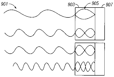
[00331 Another aspect of the present disclosure is the use of harmonic signal
processing using appropriately designed transducers to get measurements at
multiple
frequencies. The concept is illustrated in Figure 9 where an exemplary
transducer
having two layers 903, 907 is shown. The number of layers is not to be
construed as a
limitation. The two layers have a significant difference in acoustic
impedance. The
method relies on the fact that reflected acoustic energy from the borehole
wall (and
any other reflector) in the borehole includes energy at the frequency of the
generated
acoustic wave (the fundamental frequency) as well as at harmonics of the
fundamental
frequency and the subharmonics of the fundamental frequency. In Figure 9, a
second
harmonic 905 is shown in the layer 903 resulting from second harmonic
components
in the incoming wave 901. By properly selecting signals from the individual
layers
and their polarities, it is possible to get signals at harmonics as well as
subharmonics
of the fundamental frequency. See, for example, US Patent 6,673,016 to
Bolorforosh
et al.
[00341 The present disclosure also takes advantage of the fact that the
resolution and
beam width at the fundamental frequency is different from that for the
harmonics and
the subharmonics. Figure 10 illustrates the concept A source transducer 1001
emits
a signal at a fundamental frequency with a characteristic beam width 1005.
Upon
reflection from a point such as 1011 on a reflector 1003, the reflected beam
at the
fundamental frequency 1007 has the same beamwidth (and resolution) as the
generated signal. However, the second harmonic reflection has a higher
resolution
and smaller beam size indicated by 1009. What this means is that the point
1011
would be better easier to detect (imaged) at the harmonic frequency in the
presence of
an obstruction 1013 that is within the beam 1009 (such as a drill cutting)
than at the
fundamental frequency.
[00351 Similarly, situations may exist where portions of the borehole wall are
completely in the shadow of a large drill cutting at the fundamental
frequency, but
may still be imaged at a subharmonic frequency, albeit with relatively poor
resolution.
[0036] Thus, the present disclosure envisages use of multifrequency
acquisition.
Using multi-frequencies allows obtaining borehole profile with multi-
resolution. Low
frequency will be used for extended range, and higher frequency will be use
for
13
CA 02727542 2010-12-06
WO 2009/152337 PCT/US2009/047047
shorter range. In addition the harmonics of the transmitted frequency will be
utilized
at the receiver to obtain higher resolution borehole profile using low
frequency
transmitted signal. An ultrasonic pulse is composed of a group of frequencies
which
define their spectral contents. Harmonic frequencies occur at integer
multiples of the
fundamental frequency, just like the second harmonic occurring at twice the
fundamental frequency. The second harmonic signals have the narrower beam
widths
and lower levels of the side-lobes than the fundamental signal. Furthermore,
the third
harmonic signal exhibits the narrower and lower side-lobe levels than those of
the
second harmonic signal. Achieving high bandwidth at the fundamental
transmitted
frequency and simultaneously achieving high bandwidth at the harmonic
frequency
during the receive operation can be achieve using a dual layer transducer
system in
which the effective polarity of the two layers is switched between transmit
and
receive. A single frequency transducer will be excited with its fundamental
frequency, and its harmonic (third, and fifth), or a broadband transducer will
be
excited with multi-frequencies. The transducer will receive every transmitted
frequency and its harmonics and subharmonics.
[0037] With the present disclosure, it is thus possible to estimate a standoff
of the FE
sensor at each depth and each rotational angle of the sensor during drilling
of the
borehole. This can be used to obtain more accurate estimates of the formation
properties using known correction methods. These include, for example, the
spine
and rib corrections made with nuclear measurement, adjustment of NMR
acquisition
sequences based on standoff measurements (see US patent 7,301,338 to Gillen et
al),
photoelectric factor (see US 2008/0083872 of Huiszoon). As discussed above,
the
method of the present disclosure estimates both of these quantities as a
function of
depth and the tool rotational angles.
[0038] The toolface angle measurements may be made using a magnetometer on the
BHA. Since in many situations, the FE sensor and the magnetometer may operate
substantially independently of each other, one embodiment of the present
disclosure
processes the magnetometer measurements and the FE sensor measurements using
the
method described in US Patent 7,000,700 to Cairns et al., having the same
assignee as
the present disclosure and the contents of which are incorporated herein by
reference.
[0039] Those versed in the art and having benefit of the present disclosure
would
recognize that many aspects of the method may be practiced without the
necessity of a
rotating acoustic transducer. US Patent 5,640,371 to Schmidt et al, having the
same
14
CA 02727542 2010-12-06
WO 2009/152337 PCT/US2009/047047
assignee as the present disclosure and the contents of which are incorporated
herein
by reference, discloses a method and apparatus for acoustically logging earth
formations surrounding a bore hole containing a fluid, by use of a downhole
logging
instrument adapted for longitudinal movement through the bore hole. An
acoustic
transducer assembly is provided within the logging instrument and incorporates
a
cylindrical array of piezo-electric elements with the array being fixed within
the
housing structure. The method according to the preferred embodiment of this
invention employs the use of mechanical and electronic beam focusing,
electronic
beam steering, and amplitude shading to increase resolution and overcome side
lobe
effects. The method introduces a novel signal reconstruction technique
utilizing
independent array element transmission and reception, creating focusing and
beam
steering. The transducers disclosed in Schmidt may be replaced by the harmonic
transducers discussed above. The beam-steering can be used to provide acoustic
measurements at a plurality of azimuthal angles that can then be processed in
a
manner similar to measurements made with a rotating transducer.
[0040] The processing of the data may be done by a downhole processor and/or a
surface processor to give corrected measurements substantially in real time.
Implicit
in the control and processing of the data is the use of a computer program on
a
suitable machine readable medium that enables the processor to perform the
control
and processing. The machine readable medium may include ROMs, EPROMs,
EEPROMs, Flash Memories and Optical disks. Such media may also be used to
store
results of the processing discussed above.