Note : Les descriptions sont présentées dans la langue officielle dans laquelle elles ont été soumises.
CA 02747146 2011-06-14
:
WO 2010/082938
PCT/US2009/031400
Data Acquisition and Prestack Migration
Based on Seismic Visibility Analysis
BACKGROUND
Scientists and engineers often employ seismic surveys for exploration,
geophysical research, and engineering projects. Seismic surveys can provide
information about underground structures, including formation boundaries, rock
types, and the presence or absence of fluid reservoirs. Such information
greatly
aids searches for water, geothermal reservoirs, and mineral deposits such as
hydrocarbons and ores. Oil companies in particular often invest in extensive
seismic
surveys to select sites for exploratory oil wells.
Conventional seismic surveys employ artificial seismic energy sources such as
shot charges, air guns, or vibratory sources to generate seismic waves. The
sources, when fired, create a seismic "event", i.e., a pulse of seismic energy
that
propagates as seismic waves from the source down into the earth. Faults and
boundaries between different formations create differences in acoustic
impedance
that cause partial reflections of the seismic waves. A seismic sensor array
detects
and records these reflections for later analysis. Sophisticated processing
techniques
are then applied to the recorded signals to extract an image or other
representation
of the subsurface structure.
Unfortunately, seismic analysts often find that certain subsurface features
are
poorly imaged or inadequately distinguishable. In such circumstances, the only
solutions are to pursue a more sophisticated processing technique or push for
additional data acquisition in the previously-surveyed area. Each of these
solutions
can be prohibitively expensive in terms of time and money.
SUMMARY
Accordingly, there are disclosed herein systems and methods for performing
seismic visibility analysis of selected subsurface structures. These systems
and
methods identify the seismic source and receiver positions that can best
reveal the
details of the subsurface structure. These positions can then be used as the
basis
for acquiring additional seismic data and/or subjecting a selected subset of
the
existing data to more sophisticated data processing. Because the region of
data
-1-
CA 02747146 2011-06-14
WO 2010/082938 PCT/US2009/031400
acquisition and/or processing is greatly reduced, the associated expenses are
minimized.
Some illustrative method embodiments include a seismic survey method that
includes: determining visibility of a target event as a function of seismic
source and
receiver positions; and acquiring seismic data in a region selected at least
in part to
include positions having visibility values above a threshold. The target event
can
then be imaged based on the newly acquired seismic data. The illustrative
method
embodiments also include a seismic migration method that includes: determining
visibility of a target event at the source and receiver positions of traces in
an
existing seismic survey; and re-migrating traces having visibility values
above a
threshold to image the target event. In both instances, the visibility
determination
may include using a wave equation based propagator to find, for each of
multiple
simulated shots, a reflection wavefield from the target event in a seismic
model;
and to calculate, for each of multiple receiver positions, a contribution
signal from
each reflection wavefield. The visibility determination may further include
converting each contribution signal into a source-receiver visibility value.
BRIEF DESCRIPTION OF THE DRAWINGS
A better understanding of the various disclosed embodiments can be obtained
when the detailed description is considered in conjunction with the attached
drawing, in which:
Fig. 1 shows an illustrative seismic survey environment;
Fig. 2 shows an illustrative seismic source and receiver geometry;
Fig. 3 shows illustrative seismic traces;
Fig. 4 shows a migrated depth image for an illustrative seismic model;
Fig. 5a illustrates seismic energy propagating from a source to a target;
Fig. 5b shows an illustrative graph of receiver visibility;
Figs. 6a-6c show illustrative graphs of source visibility under different
assumptions;
Fig. 7 shows an illustrative source-receiver visibility function;
Fig. 8 shows an illustrative migrated depth image for a migrated subset of
seismic data;
Fig. 9 shows a flow diagram of an illustrative visibility analysis method; and
Fig. 10 shows an illustrative visibility analysis system.
-2-
CA 02747146 2011-06-14
WO 2010/082938 PCT/US2009/031400
While the invention is susceptible to various modifications and alternative
forms, specific embodiments thereof are shown by way of example in the
drawings
and will herein be described in detail. It should be understood, however, that
the
drawings and detailed description thereto are not intended to limit the
invention to
the particular form disclosed, but on the contrary, the intention is to cover
all
modifications, equivalents and alternatives falling within the scope of the
appended
claims.
DETAILED DESCRIPTION
This disclosure provides various visibility analysis methods and systems that
identify the seismic survey source and/or receiver locations that can best
measure
the characteristics of one or more selected subsurface features. Analysts can
then
focus their acquisition and processing efforts on these regions to improve the
imaging detail for these selected features. The disclosed systems and methods
are
best understood when described in an illustrative usage context.
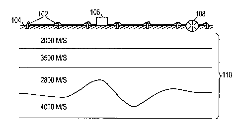
Accordingly, Fig. 1 shows an illustrative seismic survey environment, in which
an array of seismic receivers 102 are positioned in a spaced-apart arrangement
on
the earth's surface 104 to detect seismic waves. The receivers 102 are coupled
wirelessly or via cable to a data acquisition unit 106 that receives,
processes, and
stores the seismic signal data collected by the receivers. A seismic energy
source
108 (e.g., a vibrator truck) is triggered at multiple positions to generate
seismic
energy waves that propagate through the earth 110 and reflect from acoustic
impedance discontinuities to reach the receivers 102. Such discontinuities may
be
created by faults, boundaries between formation beds, and boundaries between
formation fluids. The discontinuities will appear as bright spots in the
subsurface
structure representation that is derived from the seismic signal data.
Fig. 1 further shows an illustrative subsurface model that will be used as an
example in this disclosure. In this model, the earth has four relatively flat
formation
layers with a steeply curved boundary between the third and fourth layers. The
speed of sound in each of the layers from top to bottom is 2000 m/s, 3500 m/s,
2800 m/s, and 4000 m/s, respectively. Note that for purposes of illustration,
Fig. 1
is not drawn to scale. The horizontal extent of the receiver array is expected
to be
limited to a couple of kilometers or less, while the horizontal dimension of
the
subsurface model is sixteen kilometers and the vertical dimension is five
kilometers.
-3-
CA 02747146 2014-01-13
Fig. 2 shows an illustrative geometry for source positions 202 and receiver
positions 204, as they might be seen from an overhead view. Viable seismic
survey
geometries are infinite in variety, and can be gathered on a sector-by-sector
basis, a
rolling geometry basis, a moving-array basis, and various combinations
thereof. The
main message here is that the number of receiver signals acquired in response
to
each firing of the seismic source is fairly large, and when the number of
source
firings is taken into account, the resulting number of traces can easily reach
into the
millions.
Fig. 3 shows some illustrative received seismic signal traces S1-S3. The
traces can represent displacement, velocity, acceleration, pressure, or some
other
measure of seismic energy intensity as a function of time. The signal received
by
each receiver is typically sampled and digitized to between 8 and 32 bits of
resolution at a rate of about 500 samples per second for a duration of about
30
seconds after each shot. In some cases, the receivers sense multi-component
data,
further increasing the amount of sample data for each trace. The trace data
may be
filtered and compressed before storage. The stored seismic survey data is
transported or otherwise communicated to a data processing facility.
A network of computers at the data processing facility processes the data to
estimate the volumetric distribution of sound velocities using known
techniques.
See, e.g., Jon F. Claerbout, Fundamentals of Geophysical Data Processing, p.
246-
56. Alternatively, the velocity distribution may be independently available
from
other sources, e.g., well logs. With the estimated velocity distribution, the
data
processing facility "migrates" the seismic traces, translating them from
functions of
time to functions of depth.
Various migration techniques exist, including ones based on the one-way
wave equation migration (one-way WEM), and full-way wave equation based
reverse-time migration (RTM). One-way WEM is a popular, widely applied
technique because it is effective in many cases and is relatively inexpensive
in terms
of computational complexity. However, in areas having complex structures,
especially those that generate strong overturned waves (e.g., prism waves) and
multiple reflections (which may create duplex waves), one-way WEM simply fails
to image the complex structures. This situation may be exacerbated in marine
seismic surveys since the usage of narrow-azimuth receivers limits the amount
of
cross-line offset.
RIM is able to address such imaging problems. (See, e.g., E. Baysal, D.D.
Kosloff, and J.W.C. Sherwood, "Reverse time migration," Geophysics, 48, 1514
- 4 -
CA 02747146 2011-06-14
WO 2010/082938 PCT/US2009/031400
[1983]; G.A.McMechan, "Migration by extrapolation of time-dependent boundary
values", Geophysical Prospecting, 31, 413-420 [1983]; and N.D.Whitmore,
"Iterative depth imaging by backward time propagation", SEG Expanded
Abstracts,
2, 382-385 [1983].) In recent years, RTM has become more attractive for
prestack
depth imaging processing in complex media and subsalt structures. However,
compared with the one-way WEM method, RTM is computationally expensive and
requires the data processing facility to have computers with large memories
and
large disk capacities. Moreover, RTM becomes even more challenging when
migrating high-frequency components of the wavefield due to the numerical
dispersion of the finite-difference scheme.
Fig. 4 shows a migrated depth image 402 for the illustrative seismic model of
Fig. 1. One hundred shots were simulated by finite-difference forward
modeling.
The shot position ranged from 6 km to 14 km with an 80 meter shot interval.
The
receiver aperture of each shot covered the whole model. The receiver interval
is 10
meters. The depth image of Fig. 4 was obtained by migrating all shots using
the full
aperture. In general, the curved event is well imaged but the amplitude of the
steep
dip event 404 is weak. To get a better image of this target event, it is not
necessary
to obtain large amounts of new survey data or to reprocess all of the existing
data
using RTM. Instead, we can just focus on the seismic traces that have
significant
contributions to imaging the target event. The seismic visibility analysis
methods
and systems described below will provide a quantitative identification of
which
traces provide such contributions.
Fig. 5a is a schematic ray-tracing illustration of seismic propagating seismic
energy. Ray 502 shows energy propagating from a source to one end of the
target
event and back to the surface, while ray 504 shows energy propagating from the
source to the other end of the target event and back to the surface. In
practice,
wave equation migration is employed to propagate the seismic energy downwards
as back to the surface. More specifically, visibility analysis is preferably
implemented using a wave equation based propagator rather than a high
frequency
asymptotic ray-based approach. The wave equation method is more accurate and
provides a more reliable result.
The visibility analysis takes place in two phases. First the wavefield of a
simulated shot is propagated downward and the software measures the reflection
wavefield from the target event. In the second phase, the reflection wavefield
is
propagated back and the software measures the target's contribution to the
signals
-5-
CA 02747146 2011-06-14
WO 2010/082938 PCT/US2009/031400
recorded by each receiver. The source-receiver visibility V(s,r) of the target
event is
measured by integrating the square of the measured contribution signal cõ(t)
(similar to squaring and summing each of the sample values for a trace in Fig.
3):
V (s,r)=J oT c s2,
r(t)dt,
where r is the receiver position, s is the source position, and c-(t) is the
measured
contribution signal as a function of time between the shot firing time t=0 and
the
end of the recording interval t=T. The simulated shot and receiver positions
can be
uniformly spaced throughout the model area, or they can be customized to the
contemplated survey environment (e.g., a marine streamer geometry).
The receiver visibility VR(r) is defined as the source-receiver visibility
V(s,r) for
a given source position s=S:
VR(r) = V (S,r).
Fig. 5b illustrates the receiver visibility 506 of target event 404 for the
source firing
position shown in Fig. 5a. It can be seen that for this source position, the
receiver
visibility is largely limited to a well-defined neighborhood above the target
event.
The term source visibility Vs(s) is herein defined as a summation of the
source-receiver visibility V(s,r) over all receiver positions {R}:
Vs (s) = V(s,r).
rE {R}
Fig. 6 shows the source visibility of target event 404 under three different
assumptions. Fig. 6a shows the source visibility with full receiver aperture
(i.e., all
receivers can respond to all source firings). Fig. 6b shows the source
visibility
assuming a +2 km aperture (i.e., only the receivers within 2 kilometers of the
source position can respond to the source firing). Fig. 6c shows the zero-
offset
source visibility (i.e., the receiver is co-located with the source))" In each
case, the
visibility varies with source position, and those shots in the neighborhood
above and
to the right of the target event contribute most to the visibility of the
target event.
A comparison of these source visibility functions enables the effects of
receiver
aperture to be readily quantified. A lot of visibility is lost if only the
zero-offset case
is considered.
Fig. 7 shows a map of the source-receiver visibility function V(s,r) for the
target event 404. The horizontal axis denotes the receiver location, while the
vertical axis denotes the source location. The traces for the source-receiver
-6-
CA 02747146 2011-06-14
WO 2010/082938 PCT/US2009/031400
positions found within region 702 contribute the most to the visibility of
event 404.
The visibility function along the line 704 is the receiver visibility function
VR(r) for
the source position shown in Fig. 5a. The zero-offset source visibility
function shown
in Fig. 6c is found along the 45 line 708. The source visibility shown in
Fig. 6c is
found by integrating horizontally across the entire figure. The source
visibility
function shown in Fig. 6b is found by integrating horizontally between lines
706.
The maximum receiver aperture (which corresponds to the cable length in
seismic surveys) can be selected by adjusting the spacing between the lines
706 to
capture the bulk of the nonzero area under the visibility function. The source
positions can then be selected to capture the bulk of the nonzero area under
the
source visibility function. Using this strategy to select traces (and, if
necessary,
acquire data) for prestack depth migration greatly reduces the amount of
effort
needed to improve imaging of the target event. Fig. 8 shows a depth migration
image using only the selected data, which demonstrates that the amplitude
behavior of the visibility controlled image is more balanced.
Fig. 9 shows an illustrative visibility analysis method that can be carried
out
by a computer system automatically or under the guidance of a user such as a
reservoir analyst. Beginning in block 902, the system obtains data
representing a
depth-migrated image. In many cases, this data will have been generated by the
system itself based on a previous seismic survey. In block 904 the system
identifies
one or more target events, e.g., features that have been inadequately imaged.
In
some implementations, the system identifies the target events by displaying
the
depth-migrated image to a user and soliciting input from the user about which
areas appear to be adequately or inadequately defined.
In block 906, the system selects a migration method that is more
sophisticated than the one used to generate the original data migration. For
example, the original migration could have employed one-way WEM, but the
system
may be capable of implementing full-wave RTM. Where multiple enhancements are
available, the user may select the desired migration method.
In block 908, the system determines source-receiver visibility V(s,r) using
the selected migration method to simulate shots in the tentative structure
identified
in the original depth-migrated data. As previously mentioned, the visibility
is
determined by calculating reflection wavefields from the target events for
each of
[1] As an aside, it is noted that the zero-offset visibility calculations can
be simplified using
the "exploding reflector" assumption, in which the target events are treated
as a distributed
-7-
CA 02747146 2011-06-14
WO 2010/082938 PCT/US2009/031400
multiple source positions, and then measuring the signal contributions from
these
reflection wavefields to the signals measured at each of multiple receiver
positions.
In block 910, the system identifies those existing traces whose source-
receiver positions have target event visibilities above a given threshold. The
threshold can be preset, based on a peak visibility value, or selected to
capture a
predetermined fraction (e.g., 90%) of the area under the multidimensional
visibility
surface. In block 912, the system applies the selected migration method to the
identified high-visibility traces. Because the identified traces are expected
to
represent a small subset of the available data, the use of the more
sophisticated
migration method may be eminently feasible.
In block 914, the system determines whether the target events have been
adequately imaged, and if so, the method jumps ahead to block 922. In some
implementations, the system makes this determination by displaying the depth-
migrated data to a user and soliciting user feedback. If the target event is
still
inadequately imaged, it is expected that additional data acquisition will be
needed.
Consequently, in block 916, the system identifies a survey region and other
survey
parameters based at least in part on the source-receiver visibility
calculations. In
some implementations, the range of desirable source and receiver positions can
be
determined by drawing a rectangle (for land surveys) or a parallelogram (for
marine
surveys where the receiver position varies with source position) that encloses
the
substantial bulk of the high-visibility value region.
In block 918, the system obtains the trace data from the new survey, and in
block 920 the selected migration method is applied to generate a new depth-
migrated data image of the region containing the target events. In block 922,
a
combined image is synthesized and displayed. The combined image includes the
overall structure identified from the original migrated data, but also
includes the
target events images in the newly migrated data. A reservoir engineer can then
evaluate the production potential with the structures of interest adequately
defined
for analysis.
Fig. 10 shows an illustrative visibility analysis system in the form of a
computer 50 having one or more input devices 54 and one or more output devices
56 through which it can interact with a user. Software (illustrated as
portable
information storage disks 52) configures the computer's processor(s) to
receive
user commands and responsively retrieve data from network or internal storage,
set of point explosions each having a strength equal to the reflectivity of
the target event.
-8-
CA 02747146 2011-06-14
WO 2010/082938 PCT/US2009/031400
process the data, and generate images for the user to view and analyze. When
implementing the disclosed methods, the software can typically distribute the
burden of processing the data across multiple computers interconnected by a
network.
The foregoing description relies on a 2D seismic model for explanatory
purposes. In practice, it should be expected that a 3D volume is being imaged,
and
that each of the source and receiver positions are specified in terms of at
least two
spatial coordinates. As one consequence, the source-receiver visibility map
(see Fig.
7) is expected to have at least four spatial dimensions. Nevertheless, the
underlying
principles are the same.
In summary, a seismic visibility analysis methods and systems have been
disclosed. These systems and methods quantitatively identify desirable source
and
receiver positions at the surface for a target event in complex media. The
visibility
strength for a given source-receiver geometry indicates whether a target event
is
visible or invisible with that geometry. Such knowledge is applied to
acquisition
survey design and prestack depth migration. Visibility experiments provide the
following insights:
= For a given target event, survey data outside the high-visibility
area is unnecessary.
= For a given target event, re-migration of traces outside the high-
visibility are is unnecessary.
= If a given target event has no high-visibility area, it cannot be
reconstructed with the selected migration method.
Numerous variations and modifications will become apparent to those skilled in
the art once the above disclosure is fully appreciated. It is intended that
the
following claims be interpreted to embrace all such variations and
modifications.
-9-