Note : Les descriptions sont présentées dans la langue officielle dans laquelle elles ont été soumises.
CA 02749199 2011-07-07
WO 2010/083176 PCT/US2010/020831
GEOSPATIAL MODELING SYSTEM FOR REDUCING SHADOWS AND
OTHER OBSCURATION ARTIFACTS AND RELATED METHODS
The present invention relates to the field of geospatial modeling, and,
more particularly, to geospatial modeling of imagery with shadows and related
methods.
In certain applications, detailed imagery of large and expansive
surfaces may be needed. These applications may include geographic satellite
mapping, for example, where imagery of portions of the Earth's surface are
gathered
via satellite. A typical approach for displaying the expansive data in these
applications is a mosaic image. The typical mosaic image may be formed by
several
smaller sized images. Before production of the mosaic image, each of the
smaller
images is typically registered between each other to determine their relative
position.
A typical problem encountered in mosaic images is shadowing of the
subject geographical area. For example, in optical satellite imagery, the data
collected
is based upon reflected light from the sun. In applications where the
geographical
area includes significant urban development, for example, high rise buildings,
etc., the
mosaic image may include significant shadow portions where the return data is
less
than desirable.
Since the typical application of optical satellite imagery may be
expansive and include a large number of images, there are several automated
approaches to detecting shadow portions in the images for subsequent
compensation.
For example, the shadows may be detected using edge finding techniques,
contrast
detection techniques, heuristic based techniques, and statistical techniques
that use
background estimation based upon decomposition of color changes.
Typical approaches to compensating for detected shadow portions in
applications of optical satellite imagery may include, for example, manual
approaches
where the user adjusts shadowed portions of the image using image manipulation
software, and wholesale adjustment of image brightness and contrast. A
potential
drawback to some of these approaches is that they may affect the data of the
entire
image, i.e. they change portions of the image that are not shadowed.
-1-
CA 02749199 2011-07-07
WO 2010/083176 PCT/US2010/020831
An approach to shadow removal is disclosed in the article "A System
of the Shadow Detection and Shadow Removal for High Resolution City Aerial
Photo" by Li et al., incorporated herein by reference in its entirety. This
approach
includes detecting a shadow portion in the optical satellite image. Once the
shadow
portion has been detected, the method includes determining a companion portion
that
is not part of the shadow portion but is neighboring to the shadow portion.
The
method includes determining the return data statistics of the companion area,
and
mapping the return data statistics onto the corresponding shadow portion.
Another approach to compensating for shadow portions in optical
satellite imagery is disclosed in U.S. Patent Application Publication No.
2005/0212794 to Furukawa et al., the entire contents of which are incorporated
herein
by reference. This approach includes calculating a direction of the sun in a
coordinate
system having a three-dimensional (3D) geometrical model having an object
therein,
and detecting a shadow region cast on the 3D geometrical model by a beam from
the
sun so as to identify the shadow region in the image data. The approach uses a
predetermined reflection model to estimate effects of shadings caused in the
3D
geometrical model and determines a parameter of a reflection model suited to
estimate
shadings. The approach also includes performing calculations for removing the
effects of the shadows by using the determined parameter from pixel values
sampled
from the image data so as to fit the calculated pixel values in the 3D
geometrical
model and generate a texture model.
In view of the foregoing background, it is therefore an object of the
present invention to provide a geospatial modeling system that reduces shadow
in
imagery, such as optical imagery.
This and other objects, features, and advantages in accordance with the
present invention are provided by a geospatial modeling system comprising a
geospatial model database having stored therein an initial three-dimensional
(3D)
model of a geographical area, and at least one initial image for the
geographical area.
The initial image may have actual shadow portions. The geospatial modeling
system
may also include a processor cooperating with the geospatial model database
and
-2-
CA 02749199 2011-07-07
WO 2010/083176 PCT/US2010/020831
configured to generate estimated shadow portions for the initial 3D model,
generate a
shadow difference between the estimated shadow portions and the actual shadow
portions, and reduce the actual shadow portions of the initial image based
upon the
shadow difference to generate at least one corrected image. Advantageously,
the
actual shadow portions of the initial image are accurately enhanced using the
initial
3D model.
More specifically, the processor may further be configured to reduce
the actual shadow portions by at least updating the initial 3D model based
upon the
shadow difference, generating at least one estimated image based upon the
updated
3D model and corresponding to the initial image, and reducing the actual
shadow
portions of the initial image based upon the estimated image. For example, the
processor may be configured to update the initial 3D model by at least using
gain
compensation calculations.
Additionally, the processor may be configured to reduce the actual
shadow portions by at least adding data in the initial image from the initial
3D model.
Furthermore, the geospatial model database may also store collection geometry
data
associated with the initial image. The processor may also be configured to
generate
the estimated shadow portions based upon geometric ray projection calculations
with
the collection geometry data.
In some embodiments, the geospatial modeling system may further
comprise a display coupled to the processor for displaying the corrected
image. More
particularly, the initial 3D model may comprise at least one of a digital
surface model
(DSM), a light detection and ranging (LIDAR) model, a Shuttle Radar Topography
Mission (SRTM) model, and a synthetic-aperture radar (SAR) model, for example.
Also, the initial image may, for example, comprise a two-dimensional (2D)
aerial
earth image or an electric optical (EO) image.
Another aspect is directed to a computer implemented method for
using an initial 3D model of a geographical area to generate at least one
corrected
image of at least one initial image having actual shadow portions. The method
may
include generating estimated shadow portions for the initial 3D model,
generating a
-3-
CA 02749199 2011-07-07
WO 2010/083176 PCT/US2010/020831
shadow difference between the estimated shadow portions and the actual shadow
portions, and reducing the actual shadow portions of the at least one initial
image
based upon the shadow difference to generate at least one corrected image.
FIG. 1 is a schematic diagram of a geospatial modeling system
according to the present invention.
FIG. 2 is a more detailed schematic diagram of the geospatial modeling
system of FIG 1.
FIG. 3 is a flowchart illustrating a computer implemented method for
geospatial modeling according to the present invention.
FIG. 4 is an image of the estimated shadow portions in the geospatial
modeling system of FIGS. 1 and 2.
FIGS. 5 and 6 are images of the estimated shadow portions as a
function of ambience in the geospatial modeling system of FIGS. 1 and 2.
FIG. 7 is a schematic block diagram of a geospatial modeling system
according to the present invention.
The present invention will now be described more fully hereinafter
with reference to the accompanying drawings, in which preferred embodiments of
the
invention are shown. This invention may, however, be embodied in many
different
forms and should not be construed as limited to the embodiments set forth
herein.
Rather, these embodiments are provided so that this disclosure will be
thorough and
complete, and will fully convey the scope of the invention to those skilled in
the art.
Like numbers refer to like elements throughout.
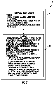
Referring initially to FIGS. 1-3, a geospatial modeling system 20
according to the present invention is now described. Moreover, with reference
to the
flowchart 30 of FIG. 3, another aspect directed to a computer implemented
method
for geospatial modeling is also now described, which begins at Block 31. The
geospatial modeling system 20 illustratively includes a geospatial model
database 21,
a processor 22, illustrated as a personal computer (FIG. 1), coupled thereto,
and a
display 23 also coupled to the processor 22. By way of example, the processor
22
-4-
CA 02749199 2011-07-07
WO 2010/083176 PCT/US2010/020831
may be a central processing unit (CPU) of a PC, Mac, or other computing
workstation.
The geospatial model database 21 illustratively stores at Block 33 an
initial three-dimensional (3D) model of a geographical area, and at least one
initial
image for the geographical area. More particularly, the initial 3D model may
comprise at least one of a digital surface model (DSM), a light detection and
ranging
(LIDAR) model, a Shuttle Radar Topography Mission (SRTM) model, and a
synthetic-aperture radar (SAR) model, for example.
In other embodiments, the geospatial model database may also store
data relating to the physical properties of the surface of 3D objects in the
initial 3D
model regarding the sensing technology, i.e. propensity to get return data,
for
example. That is, in these embodiments, the 3D model is an effective four-
dimensional model and could include more than four-dimensions if desired. In
embodiments using the DSM for the initial 3D model, the processor 22 may
generate
the initial DSM using the method disclosed in U.S. Patent Application
Publication
No. 2007/0265781 to Nemethy et al., also assigned to the assignee of the
present
invention, and the entire contents of which are incorporated by reference
herein.
Also, the at least one initial image may, for example, comprise a two-
dimensional (2D) aerial earth image, an electric optical (EO) image, and/or an
optical
satellite image. In certain embodiments, the at least one initial image may
comprise a
plurality thereof defining a mosaic image. The initial image has actual shadow
portions. As will be appreciated by those skilled in the art, the actual
shadow portions
may include areas where the return data is less than desirable for the applied
sensor
technology. The actual shadow portions may be detected using manual or
automatic
approaches, for example, edge detection. The geospatial model database 21 also
illustratively stores collection geometry data associated with the initial
image, for
example, geolocation data and collection platform telemetry data.
The processor 22 illustratively cooperates with the geospatial model
database 21 at Block 35 for generating estimated shadow portions for the
initial 3D
model. For example, the processor 22 may cooperate with the geospatial model
-5-
CA 02749199 2011-07-07
WO 2010/083176 PCT/US2010/020831
database 21 to generate the estimated shadow portions based upon geometric ray
projection calculations with the collection geometry data, i.e. ray tracing
and the like.
As will be appreciated by those skilled in the art, shadows on a 3D model
surface
from visibility of the illuminating sun may be calculated. The 3D model is
rendered
as a "minimum-range" image from the perspective of the sun with roughly half
the
separation of points on the model surface (or twice the resolution) relative
to the EO
image being compared to the model. Points on the model surface farther from
the sun
than the minimum in the image are not visible to the sun and are in shadow. By
computing the range image at a higher resolution than the EO image, this
binary
visibility image can be integrated over a pixel area to provide the fraction
of each EO
pixel in shadow.
The processor 22 illustratively cooperates with the geospatial model
database 21 at Block 37 for generating a shadow difference between the
estimated
shadow portions and the actual shadow portions. The estimated shadow portions
will
approximate the true shadows in the initial image. Nonetheless, the estimated
shadow
portions will not be a perfect match due to the limited accuracy and
resolution of the
current 3D model. Using the estimated shadow as an initial segmentation of
shadow/non-shadow of the initial image, those skilled in the art can apply
various
methods to refine the shadow/non-shadow classification of the initial image.
The processor 22 illustratively cooperates with the geospatial model
database 21 at Block 40 for reducing the actual shadow portions and other
obscuration
artifacts of the initial image based upon the shadow difference to generate at
Block 42
at least one corrected image. The processor 21 may then provide the corrected
image
on the display 23 for the user. More specifically, the processor 22 reduces
the actual
shadow portions by at least updating the initial 3D model based upon the
shadow
difference, for example, by using gain compensation calculations. Once the
true
shadow mask has been obtained from the initial image, the 3D model is modified
by
finding the minimal increase in elevation for the modeled shadow to agree with
the
true shadows. As appreciated by those skilled in the art, a number of methods
may be
applied for adjusting the gain and offsets of the shadow regions based on a
full
-6-
CA 02749199 2011-07-07
WO 2010/083176 PCT/US2010/020831
atmospheric illumination model, or in-painting based on other imagery
collected
without shadows due to different illumination resulting from collection at a
different
time of day.
The processor 22 also generates at least one estimated image based
upon the updated 3D model and corresponding to the initial image. In other
words,
the processor 22 uses the updated 3D model to provide a synthetic image with
greatly
reduced or no shadow portions that correspond to the initial image, which has
the
actual shadow portions.
The processor 22 further reduces the actual shadow portions of the
initial image based upon the estimated image. In other words, the processor 22
adds
data in the initial image from the initial 3D model. Advantageously, the
actual
shadow portions of the initial image are accurately enhanced, i.e. shadows
filled-in or
reduced, using the initial 3D model. The processor 22 ends the method at Block
44.
Referring now additionally to FIG. 4, an image 50 illustrates estimated
shadow portions for the initial 3D model as generated in the geospatial
modeling
system 20 described herein. The estimated shadow portions are generated based
upon
features in the initial 3D model, for example, the illustrated structures 51.
As will be
appreciated by those skilled in the art, the geospatial modeling system 20
generates
estimated shadows as a function of the sun's position in the sky. More
specifically,
for optical imagery, the estimated shadow portions are generated with an
estimated
sun position that corresponds to the sun position in the initial image.
Referring now additionally to FIGS. 5 and 6, images 60, 65 again
illustrate estimated shadow portions for the initial 3D model as generated in
the
geospatial modeling system 20 described herein. More specifically, the images
60, 65
have respective ambience values of 0 percent and 75 percent respectively, i.e.
the
ambience comprising the amount of scattered light from the sky. The first
image 60
represents an ambience value of 0 percent, which is total obscuration, whereas
the
second image 65 represents an ambience value of 75 percent, which is partial
obscuration. The shadows are generated based upon features in the initial 3D
model,
for example, the illustrated structures 61-63.
-7-
CA 02749199 2011-07-07
WO 2010/083176 PCT/US2010/020831
Referring additionally to FIG. 7, as will be appreciated by those skilled
in the art, an exemplary implementation 70 of the geospatial modeling system
20 is
now further described. The exemplary implementation 70 of the geospatial
modeling
system illustratively ingests the collection geometry 71 at a 3D model module
72 and
ingests the collection 74 of images 79 at a measurement module 75. The
exemplary
implementation 70 of the geospatial modeling system illustratively includes a
prediction module 73 downstream from the 3D module 72 for predicting the
shadows
based upon the initial 3D model. The exemplary implementation 70 of the
geospatial
modeling system illustratively includes a predicted shadow module 76
downstream
from the prediction module 73 for providing the predicted shadow mask based
upon
the initial 3D model.
The exemplary implementation 70 of the geospatial modeling system
illustratively includes a measured shadow mask module 77 downstream from the
measurement module 75 for determining the shadow in the initial image, and a
difference block 79 downstream from the predicted shadow module 76 and the
measured shadow mask module 77 for differencing the measured shadow in the
initial
image and the predicted shadow mask. The difference is provided at the
difference
measure module 78. The exemplary implementation 70 of the geospatial modeling
system illustratively includes an updated 3D model module 81 downstream from
the
difference block 79 for providing an updated 3D model based upon the
difference in
shadow, and a synthetic image module 82 downstream from the updated 3D model
module 81 for providing a corresponding synthetic image based upon the updated
3D
model. The exemplary implementation 70 of the geospatial modeling system
illustratively includes a mixer block 83 downstream from the synthetic image
module
82 and the measurement module 75 for combining the initial image and the
synthetic
image, and a corrected image module 84 downstream from the mixer block for
providing a corrected image 85.
-8-