Note : Les descriptions sont présentées dans la langue officielle dans laquelle elles ont été soumises.
CA 02759208 2011-10-18
WO 2010/122400 PCT/IB2010/000884
METHODS AND SYSTEMS FOR BOREHOLE SEISMIC
BACKGROUND
The present disclosure relates generally to methods and systems for performing
borehole seismic surveys relating to subterranean formations. More
specifically, some
aspects disclosed herein are directed to methods and systems for acquiring and
processing
seismic measurements in a borehole for characterizing subterranean formations
having oil
and/or gas deposits therein. The borehole seismic measurements include
rotational and
translational seismic wavefield components.
Seismic exploration can provide valuable information useful in, for example,
the
drilling and operation of oil and gas wells. Seismic measurements of the type
described
herein may also be used for a wide variety of purposes that are known in the
fields of passive
and active seismic monitoring. In seismic exploration, energy is introduced by
a seismic
source, for example, an active or a passive source of seismic energy, to
create a seismic
signal that propagates through the subterranean formation. This seismic signal
is modified to
differing degrees by features that are of interest. A receiver acquires the
seismic signals to
help generate a seismic map of the underground features. As a practical
matter, the system
may comprise a plurality of sources and receivers to provide a comprehensive
map of
subterranean features. Different configurations may yield two dimensional or
three
dimensional results depending on their mode of operation.
There is a need, however, for improving the currently available techniques for
acquiring and processing borehole seismic measurements. One object of the
present
disclosure is to provide improved techniques for deriving formation parameters
by acquiring
seismic measurements in a borehole comprising rotational and translational
components of a
seismic wavefield.
SUMMARY OF THE DISCLOSURE
The disclosure herein may meet at least some of the above-described needs and
others.
In consequence of the background discussed above, and other factors that are
known in the
field of formation analysis, the applicant recognized the need for methods and
systems for
acquiring and processing seismic measurements for purposes of monitoring
subterranean
formations in a reliable, efficient manner. In this, the applicant recognized
that techniques
were needed that could eliminate, or at least reduce, shortcomings that are
inherent in the
-1-
CONBRMAWNCOPY
CA 02759208 2011-10-18
WO 2010/122400 PCT/IB2010/000884
conventional methods and systems for borehole seismic, in particular, Vertical
Seismic
Profile (VSP) type surveys.
Applicant recognized that rotational seismology techniques may be utilized in
borehole
environments. The applicant further recognized that evolving rotational sensor
technology
could be advantageously adapted and utilized in borehole environments to
provide seismic
results and answer products that are not easily possible with presently
available techniques
and systems.
In some aspects, the present disclosure teaches the use of a combination of
rotational
seismic data, acquired by at least one rotational sensor, with translational
seismic data from a
spatial array to derive formation parameters such as elastic anisotropy. A
spatial array of
translational sensors, i.e., two or more translational sensors that are
arranged in a spatially
separated configuration, provides the capability to derive the spatial
derivative which in
combination with the rotational element gives an improved technique for
formation
parameter analysis as discussed in further detail hereinafter. The disclosure
contemplates
various arrangements of the sensors. For example, the translational and
rotational sensors
may be deployed along a vertical or a horizontal borehole at different depths
as desirable or
necessary. The sensors may also be configured in a sensor package of a tool
such as
Schlumberger's Versatile Seismic Imager ("VSI"). The translational sensor
array may
comprise combinations of three-component (3C) geophones or accelerometers as
desirable or
necessary based on the operational circumstances.
In other aspects of the present disclosure, the formation analysis techniques
utilize.a
combination of one or more rotational sensors and one or more translational
sensors to derive
measurements of shear-wave splitting. As discussed in further detail below,
the combination
of at least one rotational sensor with a translational sensor, such as a three-
component (3C)
geophone, provides the capability to obtain shear-wave splitting measurements
without the
necessity of a geophone array as is typically required in conventional shear-
wave
measurement techniques.
Methods and systems disclosed herein are directed at the deployment of seismic
receiver instruments in boreholes traversing subterranean formations to
monitor key
formation parameters that are derived from rotational and translational
components of
seismic wavefield measurements. The receiver instruments may comprise a set of
rotational
sensors and at least one three-component (3C) geophone packaged in a shuttle
with a
plurality of shuttles in an array spaced along the borehole.
-2-
CA 02759208 2011-10-18
WO 2010/122400 PCT/IB2010/000884
In certain embodiments herein, a system for taking seismic measurements
relating to
subterranean formations comprises a tool configured or designed for deployment
at.at least
one depth in a borehole traversing a subterranean formation. The tool includes
at least one
rotational sensor configured or designed for sensing rotational components of
a seismic
wavefield and at least one translational sensor configured or designed for
sensing
translational components of a seismic wavefield. A computer in communication
with the tool
is provided, and a set of instructions executable by the computer that, when
executed, process
the seismic measurements and derive parameters relating to the formation based
on the
seismic measurements.
In one aspect of the present disclosure, the system may comprise one or more
sources
configured or designed for generating a seismic wavefield. The one or more
sources may be
located at the surface adjacent the borehole traversing the subterranean
formation and the
system may be configured for Vertical Seismic Profile (VSP) data acquisition.
In other
aspects of the present disclosure, the one or more sources may be located in
an adjacent
borehole traversing the subterranean formation and the system. may be
configured for
crosswell data acquisition. In yet other aspects herein, the one or more
sources may be
located in the same well as the sensors.
In some embodiments, the system may be configured for seismic-while-drilling
data
acquisition. In other embodiments, the system may be configured or designed
for passive
seismic monitoring. In yet other embodiments, the system may be configured or
designed for
active seismic monitoring. In certain embodiments of the present disclosure,
the system may
comprise a conveyance configured for movement of the tool in the borehole
traversing the
subterranean formation; a retainer configured or designed for permanent or
semi-permanent.
deployment in the borehole to retain the tool in the borehole and, when
deployed, being
acoustically coupled to the borehole; and/or a coupling assembly configured
for coupling the
tool with the subterranean formation.
In some aspects of the present disclosure, the at least one translational
sensor may
comprise one or more of a geophone and/or an accelerometer. The at least one
translational
sensor may comprise a three-component (3C) geophone. The at least one
rotational sensor
may comprise three rotational sensors configured or designed for sensing only
rotational
components of a seismic wavefield. In other aspects of the present disclosure,
the tool
comprises a plurality of shuttles arranged along the borehole, at least one
shuttle comprising
at least one 3C geophone and at least one set of three rotational sensors
configured or
designed for sensing only rotational components of a seismic wavefield.
-3-
CA 02759208 2011-10-18
WO 2010/122400 PCT/IB2010/000884
In one embodiment, the system includes a controller section operably connected
to the
tool and configured to adjust data acquisition parameters; a communications
interface
operably connected to the controller; and a processing unit, wherein the tool
is configured to
transmit electrical signals through the controller section and the
communications interface to
the processing unit, and the processing unit is configured to perform signal
processing using
the electrical signals from the tool. The controller may be configured to
control one or more
sources such that signals are generated at intervals of depth of the tool. In
further
embodiments herein, the derived parameters relating to the formation comprise
one or more
of anisotropy of the subterranean structures around the tool and shear-wave
splitting
measurements.
The present disclosure provides a tool configured for deployment at at least
one depth
in a borehole traversing a subterranean formation. The tool comprises a
plurality of shuttles
arranged along the borehole. At least one shuttle has at least one set of
three rotational
sensors configured or designed for sensing only rotational components of a
seismic wavefield
and at least one translational sensor configured or designed for sensing
translational
components of a seismic wavefield, wherein the at least one translational
sensor comprises a
three-component (3C) geophone.
A method for taking seismic measurements relating to subterranean formations
is
provided. The method comprises deploying a tool at at least one depth in a
borehole
.20 traversing a subterranean formation. Utilizing the tool comprising at
least one rotational
sensor configured or designed for sensing rotational components of a seismic
wavefield and
at least one translational sensor configured or designed for sensing
translational components
of a seismic wavefield to detect rotational and translational components of a
seismic
wavefield. The seismic measurements are processed to derive parameters
relating to the
formation based on the rotational and translational components in the seismic
measurements.
In some aspects, the derived parameters relating to the formation may comprise
one or more
of slowness of the subterranean structures around the tool and shear-wave
splitting
measurements.
Additional advantages and novel features will be set forth in the description
which
follows or may be learned by those skilled in the art through reading the
materials herein or
practicing the principles described herein. Some of the advantages described
herein may be
achieved through the means recited in the attached claims.
-4-
CA 02759208 2011-10-18
WO 2010/122400 PCT/IB2010/000884
THE DRAWINGS
The accompanying drawings illustrate certain embodiments and are a part of the
specification. Together with the following description, the drawings
demonstrate and explain
some of the principles of the present invention.
FIGURE 1 A illustrates schematically one exemplary operational context of the
present
disclosure with an exemplary borehole system for monitoring subterranean
formations
according to the principles described herein.
FIGURE 1 B shows a conventional method of computing slowness curves using
walkaway VSP data.
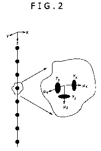
FIGURE 2 is a schematic representation of one possible borehole arrangement of
rotational and translational sensors in arrayed shuttles.
FIGURE 3A shows synthetic seismic waveforms generated using 2D fumite
difference
modeling showing results for a vertical force located at (top) 250m, (middle)
500 m and
(bottom) 750m from a vertical receiver array. Direct P and SV wave arrivals
are indicated.
FIGURE 3B is a graphical representation of recovered slowness data using the
combined rotational and translational array data. Data derived from the P-wave
arrivals and
data derived from the SV-wave arrivals are marked.
FIGURE 4A is a schematic explanation of the phenomenon of shear-wave
splitting.
FIGURE 4B is a schematic representation of one possible method used in
performing a
seismic survey according to the principles described herein.
FIGURE 4C is a schematic representation of one possible method for shear-wave
splitting measurement according to the principles described herein.
FIGURE 5 is a schematic representation of some possible configurations for
seismic
shuttles having sensors according to the disclosure herein.
FIGURE 6 is a schematic representation of yet another possible seismic sensor
shuttle
according to the principles discussed herein.
FIGURE 7 is a block diagram representation of the configuration of one
possible
seismic acquisition system according to the principles discussed herein.
FIGURE 8 outlines steps in one method according to the present disclosure.
Throughout the drawings, identical reference numbers and descriptions indicate
similar,
but not necessarily identical elements. While the principles described herein
are susceptible
to various modifications and alternative forms, specific embodiments have been
shown by
way of example in the drawings and will be described in detail herein.
However, it should be
understood that the invention is not intended to be limited to the particular
forms disclosed.
-5-
CA 02759208 2011-10-18
WO 2010/122400 PCT/IB2010/000884
Rather, the invention includes all modifications, equivalents and alternatives
falling within
the scope of the appended claims.
DETAILED DESCRIPTION
Illustrative embodiments and aspects of the invention are described below. It
will of
course be appreciated that in the development of any such actual embodiment,
numerous
implementation-specific decisions must be made to achieve the developers'
specific goals,
such as compliance with system-related and business-related constraints, that
will vary from
one implementation to another. Moreover, it will be appreciated that such
development effort
might be complex and time-consuming, but would nevertheless be a routine
undertaking for
those of ordinary skill in the art having the benefit of this disclosure.
Reference throughout the specification to "one embodiment," "an embodiment,"
"some
embodiments," "one aspect," "an aspect," or "some aspects" means that a
particular feature,
structure, method, or characteristic described in connection with the
embodiment or aspect is
included in at least one embodiment of the present invention. Thus, the
appearance of the
phrases "in one embodiment" or "in an embodiment" or "in some embodiments" in
various
places throughout the specification are not necessarily all referring to the
same embodiment.
Furthermore, the particular features, structures, methods, or characteristics
may be combined
in any suitable manner in one or more embodiments. The words "including" and
"having"
shall have the same meaning as the word "comprising."
Moreover, inventive aspects lie in less than all features of a single
disclosed
embodiment. Thus, the claims following the Detailed Description are hereby
expressly
incorporated into this Detailed Description, with each claim standing on its
own as a separate
embodiment of this invention.
Referring to Figure 1A, as mentioned above it is desirable to use seismic
information to
develop maps or images of underground features using a seismic source 206
generating
seismic wavefield 216. In this, the source of seismic energy may be a
controlled seismic
source or a passive seismic source. Seismic energy propagating through
subterranean
formations is used to determine the geological characteristics of the
underground strata in the
region surrounding the well 200 in which a seismic sensor package or sonde 202
is placed.
Source 206 can be any of a plurality of controlled source types including, but
not limited to, a
vibrator, an airgun, or any other type of source that is known to persons of
skill in the art for
the purposes described herein. Receiver instruments or sensors of the sonde
202 detect these
-6-
CA 02759208 2011-10-18
WO 2010/122400 PCT/IB2010/000884
seismic waves after they have traveled through the underground strata. After
processing, the
measured waves can be used to determine the characteristics of the surfaces in
the strata
through which they have traveled.
Borehole seismic measurements typically use three-component (3C) geophones (or
accelerometers) which measure translational movements of the earth in three
orthogonal
directions. These measurements use several sets of three-component geophones
arranged at
different depths in the borehole forming an array. The resulting survey is
typically referred to
as a Vertical Seismic Profile (VSP). From these borehole seismic measurements
it is possible
to derive various elastic properties, i.e., parameters, of the subsurface
which can be used in,
for example, exploration and development of hydrocarbon reservoirs, CO2
sequestration,
water reservoir monitoring, among other applications that are known to those
skilled in the
art. One set of properties that can be measured is that of elastic anisotropy
which describes
the directional variation of the seismic wave properties. Such measurements
are important
since if these variations are neglected during data processing they can cause
sub optimal
results.
One way to measure elastic anisotropy is to use a walkaway VSP where a seismic
source is progressively moved away from the well while the receivers are kept
stationary in
the borehole. In the case that the sub-surface structure is essentially flat
so called slowness
curves can be constructed by differentiating the arrival times of the seismic
wave arrivals
with respect to depth and offset (note Figure 1 B). In Figure 1 B, one
conventional method of
computing slowness curves using walkaway VSP data is depicted in which travel
times are
picked for the direct P-wave arrival and are differentiated with respect to
depth (top left) and
offset (bottom left). When the horizontal and vertical slowness are cross-
plotted the slowness
curves are reconstructed (right). In the case that the receiver array is
located-in an anisotropic
region the slowness curve will be distorted from a circle, and furthermore,
this measured
slowness curve can then be matched to theoretical slowness curves to give
quantitative
estimates of anisotropy. Such processing techniques are described in, for
example, Miller, D.
E., and Spencer, C., 1994, "An exact inversion for anisotropic moduli from
phase slowness
data", J. Geophys. Res., 99, 21651-21657. However, the application of this
method is
limited by the assumption of near horizontal layering in the region between
the receiver and
the source. In this, one object of the present disclosure is to provide an
improved technique
for constructing such slowness curves which does not require such an
assumption.
Figure 2 is a schematic depiction of one possible arrangement of rotational
and
displacement sensors 202 in an array. At each level in the array (shown as
black circles)
-7-
CA 02759208 2011-10-18
WO 2010/122400 PCT/IB2010/000884
there may be, for example, at least three rotational motion sensors and three
translational
motion sensors. The seismic sensor array is usually suspended from a cable 204
which also
conveys from the surface the power to operate the sensors and associated
downhole
electronics, and to the surface various signals from the sensors.
Referring also to Figure 1A, the signal 216 propagates throughout the
formation to
sensors 202. A clock measures the time of generation of the seismic signal 216
and the time
of receipt of the signal at receiver(s) 202. As used herein, the terms
"receiver" and "sensor"
include any suitable device that is configured for detection of source signals
and associated
noise for the purposes described herein. In aspects of the present disclosure,
seismic
measurements are acquired from a receiver array comprising both 3-component
geophone
sensors or accelerometers and 3-component rotational sensors deployed in a
borehole.
Rotational sensors of the type described herein may include sensors that are
based on, for
example, ring laser angular rotation sensor technology, magnetohydrodynamics
(MHD)
sensor technology, and rotating coil type sensors. In this, various types of
rotational sensors
may be developed and utilized-for the borehole seismic applications of the
type described
herein.
In some embodiments herein, the measurements are used to extract slowness
components of a seismic wavefield which can then be inverted to obtain
estimates of the
anisotropy around the receivers. In other embodiments, the measurements
derived from a
combination of rotational and geophone sensors deployed in a borehole can be
used to
measure shear-wave splitting. In this, as also described in further detail
below, the present
disclosure provided techniques for obtaining shear-wave splitting measurements
without the
necessity of an array of sensors. Shear-wave splitting can be reliably
measured in anisotropic
formations using waveforms generated by two orthogonal shear-wave sources
recorded on
two orthogonal receiver components. The resulting data can be arranged in a
2x2 data matrix
which can then be processed to determine the fast and slow shear wave
directions and the
time delay between the arrivals. The two shear-wave velocities can then be
derived using an
array of such measurements. In this, the present disclosure teaches that an
additional
recording of two orthogonal rotational sensors allows the measurements of
shear-wave
velocities at a single level without the use of a spatially spaced receiver
array.
The present disclosure contemplates application of the principles herein to
various areas,
such as wireline, seismic-while-drilling, permanent monitoring, hydro-fracture
monitoring,
production logging, among others. The systems and methods disclosed may be
utilized for
active or passive seismic monitoring in connection with oil and gas
exploration and
-8-
CA 02759208 2011-10-18
WO 2010/122400 PCT/IB2010/000884
development, CO2 sequestration, water reservoirs, and microearthquakes. In
this, the receiver
equipment disclosed herein may be deployed in boreholes on land or in the sea.
In Figure 1 A, borehole 200 may be a previously drilled well, such as a
production well
or a monitoring well, with the sensor shuttle 202 that is used to acquire
translational and
rotational components of a seismic wavefield 216. Although one shuttle is
depicted in Figure
IA, a series of shuttles may be provided as desirable or necessary (note
Figure 2). The
source 206 may be any type of suitable instrumentation for generating the
desired controlled
signals, or the source of the seismic signals may be microearthquakes induced
by fracturing
propagating through underground strata. The seismic signals 216 propagate
through the
formation, and some signals reach the sensor shuttle 202 having one or more
receiving
devices for detecting the seismic signals. The sensor arrangement 202 and the
associated
receiving devices may be used as the primary apparatus for collecting the
seismic
measurements, as described in greater detail below. One or more clocks are
used to measure
the exact time that the signals 216 are generated and when the signals are
detected at the one
or more receiving device.
In one embodiment, a suitable cable 204, for example, a wireline, slickline,
or other
conveyance that is configured for data telemetry, is provided for
communication uphole with
a controller module 214 on the surface of the borehole. The analysis module
214 may be a
stand alone, or may be integrated into a field vehicle as shown in one example
of Figure IA.
According to the principles described herein, the shuttle section(s) may be
moved
through the borehole 200 by winch 210, via a suitable arrangement in the
drilling tower 208.
A device 212 may be used to record the depth of the section 202. In one
embodiment, the
section 202 may be lowered to a predetermined depth in the borehole 200 and
then the winch
210 pulls the conveyance 204, and thus the section 202, up through the
borehole 200.
Figure 3A depicts synthetic seismic waveforms generated using 2D finite
difference
modeling showing results for a vertical force located at (top) 250m, (middle)
500 in and
(bottom) 750m from a vertical receiver array. Each seismogram panel shows x
and z
component acceleration recordings (left and middle columns) and the y-
component of the
rotation rate. In Figure 3B, recovered slowness data using the combined
rotation and
acceleration array data are illustrated. The black continuous lines show the
theoretical P- and
SV-wave slowness curves. Overlain on the theoretical curves are the computed
slowness
data for the P-waves and the computed slowness for the SV-waves. These
measured slowness
points appear as darker portions overlying the theoretical(correct) slowness
curves.
-9-
CA 02759208 2011-10-18
WO 2010/122400 PCT/IB2010/000884
As previously discussed, measurements of slowness components can be obtained
from
walkaway and 3D VSPs. In these cases, the arrival times of the direct P-wave
arrivals are
picked and then differentiated with respect to offset and depth to yield
horizontal and vertical
slowness components. Note again Figure 1 B. If these quantities are then cross-
plotted
against each other they can be used to reconstruct a slowness curve which is
characteristic of
the. elastic anisotropy around the receiver array. However, such methods are
subject to
several limitations. One limitation is that the technique is limited to
velocity structures which
are essentially plane layered. Another limitation is that the technique relies
on accurate travel
time picks.
The present disclosure provides a combination of at least one rotational
sensor and at
least one displacement sensor configured or designed to form an array that can
yield
estimates of the slowness vector which can be inverted to derive estimates of
seismic
anisotropy. In some embodiments disclosed herein, a sensor package or sonde
may have an
array of a 3C geophone and 2 or 3 rotational sensors arranged for receiving
rotational and
translational components of seismic wavefields. Note again Figure 2. In this,
the techniques
described herein are not limited by overburden complexity, and there are no
requirements for
accurate travel time picking.
The present applicant noted that there is a relationship between the
rotational and
translational components of a seismic wavefield. These relationships are based
on spatial
derivates, i.e., how the wavefield changes from one point in space to another.
As discussed
in more detail below, the relationship can be shown to take the following
form:
sX i 12ry - Dux J Equation 1.
wa_ Az
+ (2r, + buy Equation 2
s y = waj Az
where aZ are the amplitudes of the seismic displacement wavefield measured on
the z-
geophone component, rx and ry are the rotational components of the seismic
wavefield as
measured about the x and y directions, (Au,, /Az , Auy /Az) are measurements
describing how
the horizontal wavefield displacement changes in depth and w is the angular
frequency, i.e.,
co =27tf, where f is frequency.
-10-
CA 02759208 2011-10-18
WO 2010/122400 PCT/IB2010/000884
Since it is possible to measure all of the quantities on the right hand side
of Equations 1
and 2 using a combination of rotational sensors to measure rx and ry and, for
example, a 3-
component geophone array to measure az, our/A,, Auy/Az, the horizontal
slownesses sX and sy
can be calculated. The remaining component of vertical slowness (sz) can be
derived from
the geophone array. Thus a 6-component array may be used to extract the three
components
of the slowness vector which can then be inverted to yield estimates of the
seismic anisotropy
around the receiver array.
A description of the full seismic wavefield requires both a translational
displacement
vector, u = (u= uy u= y, and also a rotational displacement vector, R = (r ry
r)' . The rotational
displacement vector is related to the translational displacement vector
through the vector
differential curl operator:
R= 2VxU Equation 3
Explicitly writing the rotation vector components in terms of the spatial
derivatives of
the displacement vector wavefield gives:
1 au au
rx = 2 ay - az Equation 4
ry 1 aux - auz Equation 5
2 az ax
r, = 2 a - au" Equation 6
In Equations 4 to 6 above, the vertical derivatives, i.e., au=/aauy/az, can be
derived from
a vertical array of translational motion sensitive transducers such as
geophones,
accelerometers, and the like.
The general equation of a polarized plane wavefield can be written as:
U Equation 7
where A = (a, ,y a, )T is the polarization amplitude of the seismic wavefield,
co is the angular
frequency, i.e., w=2mf , where f is frequency, s = (s= 3y S= )r is the
slowness vector, and
X = (s y :r is the spatial position vector.
By computing the horizontal derivatives that appear in the expressions for the
rotational
vector, i.e., au,laa, au=lay and auylax,aurlay, the following are obtained:
-11-
CA 02759208 2011-10-18
WO 2010/122400 PCT/IB2010/000884
au,
_ s
-iwa,sxe Equation 8
ax
auZ - "(r-s.X)
= -iwaZsye Equation 9
ay
auy = -iwaysXe'w('-s.X) Equation 10
ax
and
u _ -iwaXsye`w('-S.X) Equation 11
Referring to Equations 4 to 6 for the rotation components expressed in terms
of the
spatial derivatives of the displacements, and dropping the exponential
harmonic term
which is a common factor throughout, the following are obtained:
sX = - i 12ry - Dux Equation 1 (above)
wa. Az
sl, _ + i [21; + Duy Equation 2 (above)
wa, Az
A change in notation for the vertical derivatives from (aux /a,, au, lay) to
(A,_ /& , eiy/Az) is used to
indicate that these quantities are derived from discrete elements in the
vertical geophone
array.
Since all the quantities on the right hand side can be measured from either
rotational
sensors (rs,ry) or a vertical geophone array (a,, auy/az, aux/az), it is
possible to measure the
horizontal components (sx, sy) of the slowness vector. The vertical component
of the
slowness vector (si) can be derived from the vertical geophone array. In
consequence, a
combination of rotational seismometers and a vertical geophone array can be
used to compute
all components of the slowness vector.
An additional constraint on the computed horizontal slownesses can be derived
through
a consideration of the vertical component of rotation:
aysX + axs.) _ - 2iri Equation 12
CO
Equations 1, 2 and 14 can be expressed in a linear form which can be solved to
obtain
the slowness vector either at a single frequency or at multiple frequencies:
M.SH = D Equation 13
-12
CA 02759208 2011-10-18
WO 2010/122400 PCT/IB2010/000884
where
aZ 0
M = w 0 a2
- ay aX
and
+ Au-
ry Az
Au A:
D= -i -2r
"
2r-
and
Sx
SH=Sy
The linear expression given in Equation 15 above describes an over determined
problem of two unknowns and three equations that can be solved to obtain the
horizontal
slowness components at each frequency. It is noted that more convenient forms
for these
expressions can be constructed from the rate of rotation, i.e., the time
derivative of rotation,
and the first and second time derivatives of displacement, i.e., particle
velocity and
acceleration. Once these slowness components are derived they can then be
inverted to yield
estimates of the elastic anisotropy over the receiver array.
It is also to be noted that more sophisticated signal processing techniques
can make use
of the combined array of rotation sensors and conventional translation sensors
such as a
parametric inversion or related techniques. See, for example, Esmersoy, C.,
1990, "Inversion
of P and SV waves from multicomponent offset vertical seismic profiles",
Geophysics, 55 (1)
39-50 and Leaney, W. S., 2002, "Anisotropic vector plane wave decomposition
for 3D VSP
data", SEG, Expanded Abstracts, 21 (1), 2369-2372. It is likely that the
application of such
techniques will yield better estimates of both the horizontal and vertical
slowness components
as they deal with the issue of interfering wavefields.
Full waveform synthetic data were constructed to demonstrate the principles
discussed
above. Figure 3A shows the waveforms for a simple homogeneous anisotropic
space with
anisotropic parameters described by the Thomsen anisotropy parameters of E=0.2
5=0.0 and
y=0Ø The seismic wavefield was simulated using a vertical force which is
located at offsets
of 250 m (top), 500 m (middle), and 750 m (bottom) from a vertical receiver
array. This
vertical receiver array extends from 10 m below the horizontal surface with
150 receivers
spaced 10 m apart. At each receiver both the rotational and translational
wavefield were
-13-
CA 02759208 2011-10-18
WO 2010/122400 PCT/IB2010/000884
recorded, and are shown in Figure 3A. By applying the techniques discussed
herein the
slowness curves as shown in Figure 3B were reconstructed.
One particularly unique signature of seismic anisotropy is the phenomenon of
shear-
wave splitting, also known as shear-wave birefringence. In this case, two
shear-wave waves
can propagate with velocities and polarizations which depend on the
propagation direction.
Figure 4A is a schematic illustration showing the phenomenon of shear-wave
splitting. A
vertically propagating shear-wave that is polarized in the E-W direction
enters an anisotropic
medium where the anisotropy is caused by vertically aligned fractures striking
N45E. The
shear-wave splits into a fast shear-wave polarized N45E, parallel to the
fracture strike, and a
slow shear-wave polarized S45E, parallel to the fracture normal. The two shear-
waves
propagate at different velocities leading to a time delay between them. VSPs,
such as zero or
near offset VSPs, can be used to measure this effect with shear-wave sources
on the surface
of the earth, and the seismic energy is recorded downhole using an array of
geophones or
accelerometers. One robust way to estimate shear-wave splitting is to measure
the
waveforms generated by two orthogonal shear-wave sources on two orthogonal
geophones
(note Figure 4B). As depicted in Figure 4B, an in-line shear-wave source (Sv)
and a cross-
line shear-wave source (Sh) may be utilized to generate in-line and cross-line
seismic
wavefields that are recorded by corresponding receiver instrumentation. Such a
configuration
can be used with a VSP where in-line and cross-line shear-wave sources are
deployed on the
surface, and the resulting waveforms recorded downhole on, for example, a
temporarily
deployed receiver array. Rotation analysis, which is often referred to as the
Alford rotation,
can be performed on the recorded measurements. See Alford, 1986, "Shear Data
in the
Presence of Azimuthal Anisotropy", SEG, Expanded Abstracts.
Such rotation analyses determine the fast and slow shear-wave directions. The
data can
then be rotated into these directions and the time delay between the fast and
slow shear-wave
directions can be determined by cross-correlation. Note Figure 4C. Such
processing can be
applied at several different receiver levels allowing the shear-wave speeds to
be measured.
In aspects of the present disclosure, a combination of conventional seismic
sensors,
such as geophones or accelerometers, are combined with rotational sensors so
that the shear-
wave speeds can be measured at a single level without the need for a spaced
receiver array.
In this, the present applicant recognized that a mathematical relationship
that describes the
relation between rotational and translational motions could be used
effectively and efficiently
to derive the horizontal slowness component. See Igel, H., Flaws, A.,
Suryanto, W.,
Schuberth, B., Cochard, A., Schreiberg, U., Velikosoltsev, A., 2004,
"Rotational Motions in
-14-
CA 02759208 2011-10-18
WO 2010/122400 PCT/IB2010/000884
Seismology: Theory, Instrumentation and Observations", FGS Workshop on Ring
Lasers and
Earth Rotations, Wettzell, Germany March 24-25. Previous techniques have used
the
relationship for the special case of the rotational field associated with a
horizontally polarized
shear wave. However, to applicant's knowledge such prior techniques do not
consider or
suggest the more complex situation of shear-wave splitting estimation.
In aspects of the present disclosure, a combination of rotational sensors and
conventional seismic sensors is provided along with shear-wave-sources to
estimate shear-
wave splitting attributes at a single level. rather than utilizing a receiver
array as is the
common practice. Data are collected from the conventional seismic sensors and
shear-wave
sources and are processed using an Alford rotation (or equivalent) to find the
fast and slow
shear-wave directions of the anisotropic medium. The data from the
conventional seismic
data and the rotational sensors are rotated into this `natural' co-ordinate
frame. It can be
shown that ratios of the conventional seismic data to the rotational data
yield information of
the fast and slow shear-wave velocities without the use of additional receiver
levels. A
schematic representation of one method for estimating shear-wave splitting is
given in Figure
4C.
Now considering vertically propagating plane shear waves in an anisotropic
medium:
im(r-rF-?
OF = AFe VF Equation 16
;wt-tS-?
US = Ase VS Equation 17
where As and" AF are the polarizations of the slow and fast shear waves; vs
and vF are the
vertical velocities of the slow and fast shear waves; and is and t F are the
arrival times of the
slow and fast shear waves.
If the fast shear wave is polarized in the horizontal plane at an angle 0
then:
cos B
AF = IA F I sin 0 Equation 18
0
and
cos(B + 90) - sin(O)
As = I AS sin(6 + 90) = I As cos(O) Equation 19
0 0
-15-
CA 02759208 2011-10-18
WO 2010/122400 PCT/IB2010/000884
Using the data from the conventional seismic sensors and the two shear-wave
sources,
the Alford rotation, or an equivalent processing step, is applied to derive
the fast and slow
shear-wave directions, 0. The waveform data are rotated into this new co-
ordinate frame
(denoted xl,x2,x3) thus separating the data onto two orthogonal components,
such that the fast
shear wave is polarized on the x j component and the slow shear wave is
polarized on the x2
component:
1
1W (1-1F --
OF = AF 0 e VF Equation 20
0
and
0
1m r-ts--
Us = As 1 e VS Equation 21
0
The rotational displacement vector is related to the translational
displacement vector
through the vector differential curl operator:
R= -Vx U. Equation 3 (above)
Explicitly writing the rotation vector components in terms of the spatial
derivatives of
the displacement vector wavefield gives:
r, = 1 au3 - au2 Equation 22
2 axe ax3
r2 1 au, - au3 Equation 23
2 av3 ax,
r3 = 1 au2 - au, Equation 24
2 ax, axe
Using the curl operation the corresponding rotational wavefield components for
the two
shear waves in this co-ordinate frame are:
0
RF = - rw AF 1 e VF Equation 25
2VF 0
and
-16-
CA 02759208 2011-10-18
WO 2010/122400 PCT/IB2010/000884
,w [ii:J, -
Rs = -1 Z IV s I 0 e vs Equation 26
s o
Combining together Equations 20 and 25, and Equations 21 and 26, describing
the
displacement and rotation in the `natural' co-ordinate system, to get:
VF = - iwu'F Equation 27
r2F
and
iw u2s
Vs - - Equation
ri s
28
As described above, it is possible to combine data from conventional seismic
sensors
and rotational sensors to measure the velocities of the fast and slow shear
waves without the
requirement of an array.
Figure 5 shows some possible configurations for a receiver section or module
according
to the principles described herein. Sections 500 and 502 are examples of a
tool module with
a receiver section 202 such as illustrated in Figures 1A and 2 and described
above. In this,
section 500 may include one or more 3C-geophone and one or more 3C-rotational
sensor that
are packaged in the section 500. Section 502 includes a coupling member 504,
for example,
a bowspring, for coupling the receiver section to the borehole wall.
In certain instances an undesirable signal to noise ratio might be created,
and tool
design combined with signal processing for noise cancellation may be desirable
or necessary
for the purposes described herein. In addition to other sources, acoustic
noise is expected
from tubewaves and turbulent flows around the tool. The first approach is
mechanical,
essentially designing the tool to decrease noise caused by multiple source
signals. Aside
from these mechanical solutions, another approach is to apply algorithmic
noise cancellation.
Figure 6 shows another aspect of a receiver module according to the principles
described herein where, for example, five receiver elements labeled 602 are
spaced apart.
For example, sequentially spaced receiver elements 1, 2, 4, 5 may comprise 3C-
geophones
and receiver element 3 may comprise a 3C-geophone and a 3C-rotational sensor.
The
spacing may be selected based on what is sufficient to properly acquire
seismic waveform
data, and other orientations and configurations for the plurality of receivers
may also be used.
-17-
CA 02759208 2011-10-18
WO 2010/122400 PCT/IB2010/000884
Figure 7 shows one example of a sensor section or arrangement according to the
principles discussed herein. Note, for example, Figures 1A and 2. The
acquisition front end
402 may contain the sensor elements described above, as well as their
associated connections
and electronics. For example, the acquisition section 402 may include
electronics suitable for
the relevant or desired frequencies that are to be received by the receiving
device. In this,
electronics for signal conditioning and digitization may be included as known
to those of skill
in the art. The overall operation of the system is coordinated by controller
404. The
controller is capable of adjusting the acquisition parameters for section 402
and timing the
start and end of acquisition, among its other functions. A real time clock 406
may be used to
provide the time to the controller for the determination of when a signal is
received and for
timing the appropriate collection intervals. This clock's time is used in
concert with the time
that the seismic signal is generated so that the travel time can be
determined. Information
from the controller may be sent to an analysis unit 412. In one embodiment, an
analysis unit
may be located at the surface of the borehole in platform 214 (note Figure
1A).
Communications interface 408 may be used to convey the signals output from the
controller 404 to communication cable 410, and subsequently to analysis unit
412. The
analysis unit may perform adaptive noise cancellation as well as determination
of the signal
velocity for each data collection. The functions of the analysis unit may be
distributed
between modules at the surface and downhole, as desirable or necessary for the
operations
described herein.
In certain embodiments of the present disclosure, the controller 404 and the
analysis
unit 412 are configured to measure the depth of the sensor section at any
time. One method
of accomplishing this is to measure the amount of conveyance that is output by
the winch 210
(note Figure IA). Knowing this depth, the seismic sources can be activated
with the
receivers at a variety of depths. This allows the system to ensure that
measurements are
taken at specific depths.
Referring to Figure 8, in one method according to the present disclosure, at
least one
rotational sensor and at least one displacement sensor are positioned within a
borehole at at
least one depth (note flow diagram block 52). A suitable seismic source device
is activated to
generate seismic wavefield (note block 54). As previously discussed above, the
present
disclosure also contemplates passive seismic measurements in which seismic
energy is
generated by, for example, microearthquakes propagating through subterranean
formations.
Seismic measurements are acquired at at least one depth in the borehole (note
block 56) to
-18-
CA 02759208 2011-10-18
WO 2010/122400 PCT/IB2010/000884
provide seismic information of the formation such that the measured data
relate to different
zones of interest in the formation.
The acquired data.are processed to determine key reservoir parameters (note
block 58)
relating to, for example, oil production, gas production, formation structure,
among others.
As described above, the seismic measurements having translational and
rotational
components of seismic wavefields may be used to derive anisotropy of the
subterranean
structures around the receivers and/or shear-wave splitting measurements.
The embodiments and aspects were chosen and described in order to best explain
the
principles of the invention and its practical applications. The preceding
description is
intended to enable others skilled in the art to best utilize the principles
described herein in
various embodiments and with various modifications as are suited to the
particular use
contemplated. It is intended that the scope of the invention be defined by the
following
claims.
-19-