Note : Les descriptions sont présentées dans la langue officielle dans laquelle elles ont été soumises.
WO 2011/081999 PCT/US2010/061241
TPI-1233
COOPERATING RECEIVER SELECTION FOR UMTS WIRELESS LOCATION
CROSS REFERENCE
[0001] This application claims the benefit of U.S. Patent Application No.
12/648,783, filed December 29, 2009, under Attorney Docket No. TPI-1121, the
disclosure of
which is incorporated herein by reference in its entirety. In addition, this
application is
subject-matter related to co-pending U.S. patent application entitled
"Cooperating Receiver
Selection for UMTS Wireless Location," U.S. Patent Application No. 12/648,753,
filed on
December 29, 2009, under Attorney Docket No. TPI-1120.
TECHNICAL FIELD
[0002] The subject matter described herein relates generally to methods and
systems
for locating wireless devices using cellular radio networks and other types of
voice or data
wireless communications systems. More particularly, but not exclusively, the
subject matter
described herein relates to the use of measurements provided to the network by
the mobile as
part of normal operation to facilitate the selection of receivers to
participate in the use of
network-based location techniques to locate a mobile communications device in
a Code
Division Multiple Access spread spectrum based wireless communications system.
BACKGROUND OF THE INVENTION
[0003] Early work relating to network-based wireless location systems is
described
in commonly assigned U.S. Patent No. 5,327,144 "Cellular Telephone Location
System,"
which discloses a system for locating cellular telephones using time
difference of arrival
(TDOA) techniques. Further enhancements of the system disclosed in the '144
patent are
disclosed in commonly assigned U.S. Patent No. 5,608,410 "System for Locating
a Source of
Bursty Transmissions." Early art in the location of mobile devices via network-
based Angle
of Arrival (AoA) and Hybrids of AoA and TDOA include the commonly held United
States
Patents: 4,728,959; "Direction finding localization system"; 6,119,013 and
6,108,555 both
entitled "Enhanced time difference localization system."
[0004] Enhancements for network-based wireless location systems for CDMA
systems can be found in the commonly held United States Patents: 7,340,259
"Robust,
1
WO 2011/081999 PCT/US2010/061241
TPI-1233
efficient, localization system"; 6,546,256 "Robust, efficient, location-
related measurement";
and 6,047,192 "Robust, efficient, localization system."
[0005] The ability of a CDMA-based system to maintain multiple legs between
the
mobile device and the network base station(s) is called "soft hand-off' (IS-
95/IS-2000) or
"soft-handover" (UMTS).
[0006] A soft handoff in a CDMA-based system occurs based on the beacon or
pilot
signal strength of several sets of base stations as measured by the mobile
device (User
Equipment (UMTS) or Mobile Station (IS-95/IS-2000)).
[0007] These sets are known in IS-95/IS-2000 variously as the active set, the
neighbor set, the candidate set and the remaining set. In a UMTS system, the
roughly
corresponding sets of NodeB's are deemed the active, monitored and detected
sets.
[0008] The active set is the set of base stations or NodeB's through which
active
communication is established. This definition of the active set applies to all
aforementioned
CDMA-based Wireless Communications System (WCNs).
[0009] In IS-95/IS-2000, the neighbor set is a set of base stations in
proximity to
the active base stations and includes base stations that have a high
probability of having a
pilot signal strength of sufficient level to establish communication, but
through which active
communication is not yet established. The remaining set is a set of base
stations that have
mobile detectable pilots, but are not of sufficient quality or power to be
included in any of the
other three sets.
[0010] In UMTS, in addition to the active set, two other mutually exclusive
sets are
defined. The "monitored set" includes non-active set cells nevertheless known
to the network.
In UMTS, these cells are included by the UTRAN in broadcast "CELL-INFO-LIST".
"Detected set cells" are those cells detected by the mobile station (also
called the User
Equipment or UE), which are not known to the network. In UMTS, these cells are
not found
in the CELL-INFO-LIST or in the active set.
[0011] In CDMA (IS-95 and IS-2000), the active set members typically have
higher
measured pilot signals strengths relative to the neighbor, candidate set and
remaining sets.
The mobile uses these sets to help manage the handover/handoff process known
as Mobile-
Assisted Handover (MAHO). When communications between the network and mobile
are
initially established, a mobile communicates through radio signaling with a
single base
station, typically the base station with the highest received pilot power, but
always a base
2
WO 2011/081999 PCT/US2010/061241
TPI-1233
station that meets the threshold for inclusion into the active set. During
soft-handoff, the
active set contains more than one base station. The mobile monitors the pilot
signal strength
of the base stations in the active set, the candidate set, the neighbor set
and the remaining set.
During handoff, when a pilot signal strength of a base station in the neighbor
or remaining set
reaches a defined threshold level, that base station is added to the candidate
set and removed
from the neighbor or remaining set by the mobile. When the mobile detects a
relatively strong
candidate pilot, the UE transmits a "Pilot Strength Measurement Message"
(PSMM) to a Base
Station Controller/Packet Control Unit (BSC/PCU) along with a request to add
the base
station of that pilot signal to the UE's active set. The PSMM report is
evaluated by the BSC
which coordinates the processing of a soft handoff with the base stations
associated with the
strong detected pilot signals.
[00121 In CDMA-based systems wireless communications systems, using the
UMTS WCN as an example and source of nomenclature, the concept of a `serving
cell' has
been replaced with one-way, two-way, three-way, etc. softhandoff handover
(SHO) to take
advantage of macrodiversity. In the downlink (NodeB-to-UE), macrodiversity is
accomplished by combining, in the mobile's RAKE receiver, multiple copies of
the downlink
signal caused by either transmission from multiple antennas or by the multi-
path corruption
of the transmitted signal.
[00131 In the uplink direction, macrodiversity is accomplished through the use
of
multiple receive antennas collecting multiple copies of the UE transmitted
signal. Since the
UE transmitted signal is multi-path corrupted, multiple levels of signal
combining can take
place.
[0014] In all CDMA-based radio air interface wireless communications systems,
detection of surrounding cell beacons is complicated by frequency re-use and
the power
control used to minimize the Near-Far effects.
[0015] The near-far problem is a classic co-channel interference (also called
cross-
talk) problem in cellular frequency reuse radio networks. The near-far problem
arises from
the fact that radio signals from transmitters closer to the receiver of
interest are received with
smaller radio path-loss attenuation than are signals from transmitters located
further away.
Therefore the strong signal from the nearby transmitter will mask the weak
signal from the
more distant transmitter.
3
WO 2011/081999 PCT/US2010/061241
TPI-1233
[0016] In CDMA-based radio networks, the near-far co-channel interference is
actively minimized using dynamic output power adjustment of the transmitters
both in the
uplink (UE-to-NodeB) and downlink (NodeB-to-UE) directions. With dynamic
output power
adjustment the closer transmitters (with less radio path loss) broadcast with
less power so that
the SNR for all transmitters at the serving receiver is roughly the same.
[0017] A network Wireless Location Services scenario may include hybrids with
downlink and Satellite location techniques for a CDMA-based wireless
communications
network (WCN) such as the Universal Mobile Telephone System (UMTS). The UMTS
WCN
is fully specified by the 3rd Generation Partnership Project (3GPP) since
December 1998.
[0018] Detailed descriptions of Radio messages, message elements, and
parameters
for UMTS can be found in technical specification document 3GPP TS 24.008
"Mobile radio
interface Layer 3 specification; Core networkprotocols; Stage 3" and 3GPP TS
25.331
"Radio Resource Control (RRC); Protocol specification"
[0019] Detailed descriptions of the Wireless Location Systems standardized for
UMTS are detailed in technical specification 3GPP TS 25.305 "User Equipment
(UE)
positioning in Universal Terrestrial Radio Access Network (UTRAN); Stage 2".
Details on
handovers in the exemplary UMTS network can be found in 3GPP TS 23.009;
"Handover
Procedures ", 3GPP TR 25.832; "Manifestations of Handover and SRNS Relocation"
and
3GPP TR 25.936; "Handovers for real time services from PS domain".
[0020] The ETSI and 3GPP defined term LMU (Location Mobile Unit) is
functionally equivalent to the ANSI defined term Position Determining Unit
(PDE) or to the
Signal Collection System (SCS) term as used in the cited TruePosition Patents.
In a network-
based WLS, consisting of geographically distributed receivers (LMUs) either
overlaid in or
integral to the local Wireless Communications Network with central server(s),
the Serving-
Mobile Location Center (SMC) connects to the core communications network. The
central
server(s) communicate with the WCN for the purposes of obtaining location
triggers and
collecting location tasking information which in this case includes the Active
Set of the
mobile of interest.
[0021] Prior U-TDOA systems required that at least one receiver, deemed the
reference LMU receiver, to successfully demodulate at least part of the signal
from the
mobile of interest.
4
WO 2011/081999 PCT/US2010/061241
TPI-1233
[0022] In a CDMA-based WCN with soft-handover, more than one LMU may be
able to fully or partially demodulate the signal from the mobile of interest.
The resultant full
or partial signal demodulations may, via soft-combining, be used to
reconstruct a replica of
the original transmission that is less degraded than the best replica that
could be obtained
from any of the individual demodulations. This reconstructed reference signal
is then made
available to all LMUs involved in the location for correlation processing.
LMUs that
participate in the demodulation process are called "demodulating LMUs" or
"demod LMUs."
In addition to the demodulating LMU receivers, geographically neighboring or
proximate
LMUs ("cooperators" or "coop LMUs") may be tasked to collect signals from the
mobile of
interest for correlation with the reference signal. These cooperators may be
an LMU, an LMU
sector, or multiple antennas serving the same LMU. The set of potential
cooperating LMUs
also includes the demodulating LMUs. A "demod sector" is one LMU sector that
is tasked for
demodulation. A "coop sector" is one LMU sector that is tasked for
cooperation. The
problem of identifying which LMU sectors to task for demodulation is related
to, but separate
from, the problem of identifying which LMU sectors to task for cooperation.
Although the
techniques described herein may solve both problems, they may also be used to
solving either
problem independently of the other. Thus, for example, in an embodiment in
which the WLS
is not required to collect a reference signal because the reference signal is
provided to the
WLS by the WCN, the techniques described herein can be used to identify which
LMUs to
task for cooperation. In such a case the LMUs identified as demod LMUs by
these techniques
would be used only for cooperation and not for demodulation. Not every sector
or cell may
have a LMU installed (e.g., a sparse network deployment, as described in
TruePosition's
United States Patent Applications 11/736950, 11/736920, 11/736868 and
11/736902; all
entitled "Sparsed U-TDOA Wireless Location Networks"). Both coop sectors and
demod
sectors are limited to those sectors and cells that have an associated LMU..
[0023] Thus "serving sector" may refer to the coverage area of the serving
cell. The
term "LMU sector" may be used for that portion of an LMU responsible for
receiving and
processing radio signals from one receive antenna if receive diversity is not
in use, or from
multiple antennas located in close proximity to one another and providing
diversity coverage
of the same area if receive diversity is in use.
[0024] For network-based wireless location systems operating in a CDMA-based
wireless communications network, selection of a most nearly optimal group of
uplink
WO 2011/081999 PCT/US2010/061241
TPI-1233
receivers for network-based wireless location is problematic due to the power-
control
inherent in such networks and the resulting near far problem.
SUMMARY
[00251 For the wireless location system to dynamically task the numerically
smallest, most geographically favorable set of receivers for a reliable TDOA
and/or AoA
based location and velocity calculation, the mobile device's Active Set may be
obtained from
the Wireless Communications Network and used to select from pre-determined
lists of
cooperating receivers and demodulating receivers or to construct new lists of
cooperating
receivers and demodulating receivers.
[0026] For Wireless Communications Networks (WCNs) that support soft
handover, cooperator receiver selection for a TDOA, AOA, TDOA/AOA, or hybrid
network-
based or network-overlay Wireless Location System (WLS) must contend with one
or more
network base stations as a serving cell. In a WCN that supports soft-handoff,
such as a
CDMA (Code Division Multiple Access) based system, which can be a FDD
(Frequency
Division Duplex) or a TDD (Time Division Duplex) system, the concept of a
serving cell or
serving sector is more complicated. First, the mobile device may have multiple
serving
sectors (also known as active set members). Second, each sector may have
differing numbers
of transmission and reception antennae or, in TDD-based systems, use the same
antenna for
transmission and reception. When the active set contains a single member, the
solution is
straightforward and a cooperative receiver may be selected using a number of
criteria or
methods. When the active set contains more than one member, disclosed herein
are two
techniques for determining a set of cooperators and demodulators to use in the
signal
collection for location estimation.
1. In one embodiment, a first technique is referred to as the proxy method,
since
the active set members are constructively reduced to a single member that is
used as a proxy serving cell.
2. In another embodiment, a second technique is referred to as the aggregate
method, since information contained in the active set membership is retained
and a new set of demodulating and cooperator receivers are generated based
on the entire membership of the active set.
[00271 In both techniques, the selected cooperative and demodulating receivers
are
those that are likely to provide good TDOA and AoA coverage for the mobile
device.
6
WO 2011/081999 PCT/US2010/061241
TPI-1233
[0028] CDMA mobile stations and UMTS User Equipment are based on wide-band
air interfaces and transmit at very low Eb/NO levels compared to other narrow-
band air
interfaces (including GSM, TDMA and AMPS) for which UTDOA location systems
have
been widely deployed. To date, UTDOA deployments in CDMA/UMTS have been small
enough to be practical to use every LMU receiver as a cooperator and a
demodulator to each
other LMU.
[0029] Due to the low Eb/NO levels that are used, less margin of error is
available
for demodulating receiver and cooperating receiver selection when locating
UMTS User
Equipment. The disclosed techniques for selecting demodulating and cooperating
receivers
provide a mechanism for selection of demodulating and cooperating receivers
that allow a
CDMA-based UTDOA system to achieve the same or better location accuracy
compared to
accuracies achieved by comparable UTDOA systems for other air interfaces. The
disclosed
techniques may use fewer cooperators, thus allowing higher system throughput.
Because the
number of possible distinct Active Sets is extraordinarily high, it may not be
possible to
perform this selection in advance for all cases that may be encountered.
Hence, any practical
solution may benefit from the disclosed techniques.
[0030] The disclosed techniques are also applicable to a hybrid solution that
use
mobile-based OTDOA and/or assisted GPS (A-GPS) and network based Uplink Time
Difference of Arrival (U-TDOA) technologies. Such technologies operate
independently to
obtain range estimates which can then be combined in a final hybrid location
calculation or
operate in a fallback mode where one location method is used when one or more
of the other
methods fail. Use of a hybrid wireless location system, using the disclosed
concepts, creates
an improved location solution with enhanced accuracy, yield, and performance.
Methods of
using network-based with mobile-based technologies, including satellite based
downlink
TDOA, were disclosed in TruePosition US Patent 7,440,762 "TDOA/GPS hybrid
wireless
location system" and in TruePosition US Patent Application Serial No.
12/192,057 "Hybrid
GNSS and TDOA Wireless Location System."
[0031] The inventive techniques and concepts described herein apply to code-
division radio communications systems such as the CDMAOne (TIA/EIA IS-95 CDMA
with
IS-95A and IS-95B revisions), the CDMA2000 family of radio protocols (as
defined by the
3rd Generation Partnership Project 2 (3GPP2)) and the Wideband Code-Division
Multiple-
Access (W-CDMA) radio system defined by the 3rd Generation Partnership Project
(3GPP)
7
WO 2011/081999 PCT/US2010/061241
TPI-1233
as part of the Universal Mobile Telephone System (UMTS). The UMTS model
discussed
herein is an exemplary but not exclusive environment in which the present
invention may be
used.
[0032] The present invention may be used in a network Wireless Location
Services
scenario including hybrids with downlink and satellite location techniques for
a CDMA-
based wireless communications network (WCN) such as the Universal Mobile
Telephone
System (UMTS). The UMTS WCN has been fully specified by the 3rd Generation
Partnership Project (3GPP) since December 1998. The UMTS WCN with its Wideband
CDMA (W-CDMA) radio air interface, also specified by 3GPP, will be used as an
exemplary
model throughout this document.
[0033] It should be noted that this summary is provided to introduce a
selection of
concepts in a simplified form that are further described below. This summary
is not intended
to identify key features or essential features of the claimed subject matter,
nor is it intended to
be used as an aid in determining the scope of the claimed subject matter.
BRIEF DESCRIPTION OF THE DRAWINGS
[0034] The foregoing summary as well as the following detailed description is
better understood when read in conjunction with the appended drawings. For the
purpose of
illustrating the invention, there is shown in the drawings exemplary
constructions of the
invention; however, the invention is not limited to the specific methods and
instrumentalities
disclosed. In the drawings:
[0035] Figure 1 illustrates a network-based wireless location system (WLS).
[0036] Figure 2a depicts an example selection of representative marker points
in an
omni-directional cell.
[0037] Figure 2b depicts an example selection of representative marker points
in a
cell in a sectored cell site.
[0038] Figure 2c depicts the radial segmentation and spiral algorithm pattern
for
cooperative and demodulating LMU sector selection.
[0039] Figure 2d depicts the radio propagation study output of the average
signal
quality between each serving cell and its target cooperating and demodulating
LMU sectors
in a service area.
8
WO 2011/081999 PCT/US2010/061241
TPI-1233
[0040] Figure 2e illustrates the spiral algorithm in process, selecting the
best
cooperating and demodulating LMU sectors in order of radial segmentation and
predicted
signal quality.
[0041] Figure 2f illustrates a representation of the initial cooperator lists.
[0042] Figure 2g illustrates a representation of the initial demodulating LMU
sector
lists.
[0043] Figure 3 illustrates the general operative steps in performing a Proxy
Method
for selection of cooperative and demodulating LMU sectors for a network-based
wireless
location system.
[0044] Figure 4 illustrates an embodiment of Proxy Method 1 - Select the
Active
Set Member Nearest to Centroid as the Proxy
[0045] Figure 5 illustrates an embodiment of Proxy Method 2 - Select as Proxy
Cell
the Active Set Member with the Most Active Set Members on its Demodulating LMU
List.
[0046] Figure 6 illustrates an embodiment of Proxy Method 3 - Select Proxy
Serving Cell Based on Coverage Bounding Polygons
[0047] Figure 7 details the general operative steps in performing an Aggregate
Method for selection of cooperative and demodulating LMU sectors for a network-
based
wireless location system.
[0048] Figure 8a illustrates an embodiment of Aggregate Method 1 -
Construction
of new cooperators in a round-robin fashion based on octants of active set
members.
[0049] Figure 8b depicts the Spiral Algorithm as implemented for Aggregate
Method 1 - Construction of new cooperators in a round-robin fashion based on
octants of
active set members.
[0050] Figure 8c depicts the output of the Spiral Algorithm as implemented for
Aggregate Method 1 - Construction of new cooperators in a round-robin fashion
based on
octants of active set members.
[0051] Figure 9a illustrates an embodiment of Aggregate Method 2 - Construct
new
cooperators list based on marker points of active set members
[0052] Figure 9b depicts the Spiral Algorithm as implemented for Aggregate
Method 2 - Construct new cooperators list based on marker points of active set
members
[0053] Figure 10a illustrates an embodiment of Aggregate Method 3, Construct
new
coops based on the coverage area common to all active set members.
9
WO 2011/081999 PCT/US2010/061241
TPI-1233
[0054] Figure 10b depicts the Spiral Algorithm as implemented for Aggregate
Method 3, Construct new coops based on the coverage area common to all active
set
members.
DETAILED DESCRIPTION OF ILLUSTRATIVE EMBODIMENTS
[0055] Certain specific details are set forth in the following description and
figures
to provide a thorough understanding of various embodiments of the invention.
Certain well-
known details often associated with computing and software technology are not
set forth in
the following disclosure to avoid unnecessarily obscuring the various
embodiments of the
invention. Further, those of ordinary skill in the relevant art will
understand that they can
practice other embodiments of the invention without one or more of the details
described
below. Finally, while various methods are described with reference to steps
and sequences in
the following disclosure, the description as such is for providing a clear
implementation of
embodiments of the invention, and the steps and sequences of steps should not
be taken as
required to practice this invention.
[0056] We will now describe illustrative embodiments of the present invention.
First, we provide a detailed overview of the problem and then a more detailed
description of
our solutions.
[0057] One of the main advantages of wide-band, spread spectrum CDMA-based
wireless communication systems is the capability of combining multiple signals
that arrive in
the receivers with different time delays. Unlike narrowband systems, CDMA-
based wireless
systems do not use equalization to mitigate the negative effects of multipath,
but rather
combines the multipath signals (known as `rays') using a RAKE receiver.
[0058] A RAKE receiver contains multiple demodulators, called `fingers'. Each
finger searches for rays and feeds the information to the other fingers of the
RAKE receiver.
Each finger then demodulates the signal corresponding to a strong ray. The
results from each
finger are then combined together to improve the signal quality.
[0059] In CDMA-based wireless communications systems, the techniques of soft-
handover (SHO) and softer-handover (also SHO) are used to take advantage of
the
performance enabled by multipath combining allowing improvement the voice or
data quality
as delivered with the caprices of the radio air interface. Using
macrodiversity, signals from
the antennas of the local base station can be combined to enhanced the
received signal
WO 2011/081999 PCT/US2010/061241
TPI-1233
(softer-handover) and signals from other local base stations can be collected
and merged
(soft-handover) at the base station or radio network controller.
[00601 Using the 3GPP defined UMTS system as an example of a functional
wideband, spread spectrum CDMA-based wireless communication network, it can be
shown
that network and signal information can be obtained to improve the performance
of the
Wireless Location System as to accuracy, latency, and cost.
[00611 Network-based Wireless Location Systems require a minimum of three
receivers (or two in the case of Angle-of-Arrival only based systems) to
calculate a location
estimate via algorithms known as Triangulation (AoA) and Trilateration (TDOA).
In practice,
many more receivers are typically needed to maximize location accuracy.
[0062] Network-based WLSs using multi-lateration (and multi-angulation in
combination) can improve the location accuracy by selecting only the receiver
sites with the
best reception (as determined by the signal quality, e.g., the SNR). Each pair
of receiver sites
forms a baseline pair from which the location estimation and velocity
estimation calculations
are performed. Inconsistencies between the received timing and the expected
timing can also
be used with SNR as additional or substitute receiver selection criteria.
[00631 The baseline method for TDOA/FDOA determination in a network-based
wireless location system uses signal correlation between a reference and local
signal where
the reference and local signals are collected over the same interval, as
extended and adjusted
for expected propagation delay, using different antennas via synchronized
receivers.
Figure 1
[00641 Figure 1 depicts a network-based wireless location system (WLS). The
WLS
overlays or is integrated into the wireless communications system (shown here
as the
strongest cell 102, neighbor cell 103 and proximate cell 104). A wireless
device 105 is shown
in soft-handoff with the local cells 102 103 104 via radio signaling paths 106
107 108.
Location Measurement Units (LMUs) 109 are geographically distributed to
receive the uplink
radio signals emitted by the mobile device 105. The LMUs are connected via
digital data
links 110 to the SMLC 111. The SMLC 111 or Serving Mobile Location Center
manages the
operations, maintenance, and provisioning of the LMUs 109 as well as providing
interconnection between the WLS and other wireless communications network
nodes. The
SMLC receives triggering and tasking information from the WCN via a digital
datalink 112
such as the J-STD-036 defined E5 interface, the ETSI defined Lb interface, the
3GPP defined
11
WO 2011/081999 PCT/US2010/061241
TPI-123 3
Iupc interface and/or the ATIS defined Lbis interface. If deployed in
conjunction with a link
monitoring system (LMS), the SMLC may support an alternate triggering
interface 113 for
triggering and tasking formation from the LMS. The LMS is further detailed in
commonly
assigned US Patents 6,782,264 and 7,023,383 both entitled "Monitoring of call
information in
a wireless location system" and commonly assigned Patent Application Serial
No. 11/150414
"Advanced triggers for location-based service applications in a wireless
location system".
[0065] In the network-based WLS, received signals are collected using wideband
receivers (LMUs 109) preferably using geographically distributed antenna
sites.
[0066] The reference antenna (or site) and cooperators are selected based on
received signal characteristics, a pre-planned scheme based on signal
propagation modeling
or other criteria which can include the serving cell or active set membership
for a mobile
device.
[0067] Each of the LMU 109 receivers digitizes the radio transmission received
on
the channel of interest. The acquired signal of interest (SOI) or portions of
the SOI is
demodulated by the reference receiver and distributed to the cooperating
sites. Additional
information on the specifics of this technique may be found in the commonly
held US patents
5,327,144; "Cellular telephone location system" and 6,047,192; "Robust,
efficient,
localization system."
[0068] The reference and local signals, a set of digitized samples collected
over the
sample duration, are then correlated with a set of likely time-offsets (range)
and frequency-
offsets (Doppler and drift) to create a three dimensional search space of
correlation
amplitude, range, and Doppler/drift (as per commonly assigned Patent
6,876,859; "Method
for estimating TDOA and FDOA in a wireless location system").
[0069] The said correlation procedure is repeated for each cooperating LMU 109
receiver. The correlation output may be edited to remove interference.
Additional information
on the specifics of the digital editing technique may be found in the commonly
assigned US
patent 6,765,531; "System and method for interference cancellation in a
location calculation"
[0070] Geometric dilution of precision (GDOP) measures the sensitivity of
location
accuracy to the geometry of a TDOA and/or AoA system's receiving antennas
relative to a
transmitting mobile device. GDOP can be viewed as an error multiplier that can
boost or
degrade the performance of a location system. For example, if the TDOA multi-
lateration
process has measured every baseline in a location estimate with an accuracy of
X, and the
12
WO 2011/081999 PCT/US2010/061241
TPI-1233
geometry of the antennas resulted in a GDOP of Y, then the expected error of
the final
location estimate is X*Y.
[0071] UTDOA location accuracy is highly dependent on obtaining a reference
signal obtained via partial demodulation and reconstruction by a limited
number of LMUs
and on selecting good cooperator sites. Limiting the number of LMUs is
important because if
all LMUs in the WLS were tasked to obtain a reference signal, those LMUs would
be
unavailable to perform other locations during the same time period. This would
severely
impact the availability of service (capacity and latency) of the WLS.
[0072] In order to improve reference signal detection without undue impact to
availability, a few LMU's (the demodulating LMUs) are tasked to attempt to
demodulate the
reference signal or portions of the reference signal such as the mid-amble and
the best one is
selected (or they are combined) at a later time. The initial selection of
which LMUs will be
tasked for demodulation or cooperation is static. The selection is performed
once during
system configuration for each cell in the wireless system.
[0073] While the selection of which LMUs will be tasked for demodulation or
cooperation can take into account many aspects (such GDOP or the distance
between
baseline pairs) in selecting the best sites, multi-path propagation and fading
cannot be
considered unless an extensive and expensive drive test is performed after
each system
reconfiguration. Modeling of the radio propagation environment has thus far
proven
insufficient to substitute for drive testing. In some cases the best cells for
detecting and
demodulating the reference signal are not the cells that are close to the
mobile of interest.
Subsequent revision of the initial `static' demodulation or cooperation lists
as the WCN
changes or additional drive test and survey data become available is possible.
Revision of the
lists using historical information in creating the static list is also
possible (see commonly
assigned Patent Application United States Patent Application Serial
No.11/948244,
Automated Configuration of a Wireless Location System).
[0074] In an exemplary UMTS WCN, "Soft Handover" (SHO) is a state in which a
few cells are simultaneously receiving and transmitting data to the same
mobile device. A
cell, in UMTS, corresponds to an antenna array with a defined radio coverage
area. A UMTS
cell may be an onmi-directional cell or a sectored cell which uses a
directional antenna array
to define and serve the coverage area. One or more omni-directional or
sectored cells may be
sited at a single cell site.
13
WO 2011/081999 PCT/US2010/061241
TPI-1233
[0075] With macrodiversity/soft handover the UE combines more than one radio
downlink from the local NodeB(s) to improve the reception quality. Although
the maximum
number of Radio Links that a UE can simultaneously support is eight, the
number used for
SHO can vary dynamically in the range of 1 to 6 under the control of the radio
access
network.
[0076] In general, when an RRC connection is established, it first must be
established on one cell. The UMTS network initiates Intra-Frequency
measurements at the
UE to determine if any other cells are suitable. Suitable cells have a CPICH
(common pilot
channel) strength (as measured by Ec/Io) above the dynamic threshold value
[Best SS -
AS_TH+AS_Th Hyst] for deltaT seconds. If a cell CPICH meets this threshold and
the
Active Set is not yet full (or if the measured CPICH is better than an
existing Active Set
member's CPICH strength plus As_Rep_Hyst for deltaT seconds) then the cell is
suitable.
[0077] When a suitable cell is found then Active Set Update procedure (3GPP TS
25.331 "Radio Resource Control Protocol Specification", section 8.3.4) is
initiated. Using the
Active Set Update message, the network adds or deletes one (or more) radio
link(s) to the
UE. The only requirement is that from the start until the end of this Active
Set Update
procedure, one Radio Link should remain common.
[0078] Since cells are added or removed from the Active Set based on RF
measurement reports created at the mobile/UE, cells in the Active Set are
likely to be very
good candidates for demodulation and cooperation for network-based wireless
location
methods.
Location Calculations in a TDMA/FDMA Wireless Communications Network
[0079] High precision network-based wireless location techniques that are
field
proven and in currently in wide usage include UTDOA (Uplink Time Difference of
Arrival),
Angle of Arrival (AOA) and U-TDOA/AoA hybrids.
[0080] Uplink Time Difference of Arrival (UTDOA) determines a mobile phone's
location by comparing the times at which a cell signal reaches multiple
Location
Measurement Units (LMUs).
[0081] Angle of Arrival (AOA) determines a mobile phone's location by
comparing
the angle developed by a multiple element antenna array in which the exact
location of each
antenna element is known precisely with the angle developed by another
multiple element
antenna. Each element is capable of separately receiving the uplink radio
signal. By
14
WO 2011/081999 PCT/US2010/061241
TPI-1233
measuring signal strength, time of arrival, and phase at each element of the
array, it is
possible to calculate the line-of-sight path (bearing line) from the mobile
device to the AoA
array. Use of two or more AoA equipped LMUs generates multiple bearing lines.
A location
estimate can be calculated from where the bearing lines cross.
[0082] Network-based Hybrid Location solutions using combinations of Cell ID
(CID), signal power measurements, Enhanced Cell ID (E-CID), Angle of Arrival
(AOA),
and Uplink Time Difference of Arrival (U-TDOA) can be used to increase
location accuracy
and yield in a geographic service area.
[0083] In a TDMA (Time Division Multiple Access), FDMA (Frequency Division
Multiple Access), FDD (Frequency Division Duplex) system, such as GSM, a
serving cell
(generally the cell with the best measured radio signal as received by the
mobile station) is
identified to the WLS by the WCN or Link Monitoring System (LMS) along with
radio
channel information needed to tune the geographically distributed antennas
connected to
LMU receivers. A serving cell is also known as a serving sector (in the case
of sectorized
base stations) or as a serving antenna pair (a cellular sector nominally has
at least a
transmission antenna and receiving antenna). Use of receiver diversity adds
additional receive
antennas to a sector. In this application, the term sector will be used for
the radio coverage
area of a receiver antenna or diversity receiver antenna(s) regardless of the
nature of the cell
site (Omni-directional or sectored). Thus "serving sector" will refer to the
coverage area of
the serving cell.
[0084] Prior to activation, an extensive design phase is typically conducted
on the
network-based WLS , where optimal siting of LMUs (please see commonly assigned
United
Station Patent Application Serial No. 11/736,950; "Sparsed U-TDOA Wireless
Location
Networks", Filed April 18, 2007; United Station Patent Application Serial No.
11/736, 920;
"Sparsed U-TDOA Wireless Location Networks"; Filed April 18, 2007; United
Station Patent
Application Serial No. 11/736,902; "Sparsed U-TDOA Wireless Location
Networks"; Filed
April 18, 2007; and United Station Patent Application Serial No. 11/736,868
"Sparsed U-
TDOA Wireless Location Networks"; Filed April 18, 2007) and accuracy
estimations over
the geographic service area are calculated. As part of the design phase, lists
of predetermined
cooperative LMU receivers (coop or cooperator lists) and lists of
predetermined secondary
demodulation candidate LMUs (demod lists) are generated for each sector of the
WCN.
WO 2011/081999 PCT/US2010/061241
TPI-1233
[0085] The initial cooperator list and demodulator list generation process
models the
radio path loss between an LMU sector receiver antenna(s) and a theoretical
point (a marker
point or sample point). The modeled radio path loss is used to determine the
value of a
quality metric for the radio path between each marker point and a receiver
antenna. In this
example, the extended COST231-Hata radio propagation model will be used.
[0086] One or more marker points are used to represent the coverage area of
each
cell. Marker point placement can be performed using a number of techniques
including
uniform geographic distribution, selective placement based on radio
propagation mapping,
and random placement via a Monte Carlo or other stochastic probability
technique. Simple
geometric placement will be used herein to illustrate the initial marker
placement.
[0087] Figures 2a and 2b illustrate examples of representative marker points
calculated from a simple geometric model. Figure 2a depicts an illustrative
example of the
representative marker points as calculated from a simple geometric model
overlaid on the
coverage area of a onmi-directional antenna (single cell) cell site 201. The
(n=4) marker
points 202 are distributed around the antenna site 206 at a constant radius
204 along (n=4)
individual equally distributed radials 205.
[0088] Figure 2b depicts an illustrative example of the representative marker
points
as calculated from a simple geometric model overlaid on one sector of a six
sectored cell site
203. The current sector 205 is overlaid with a simple geometric model. The
(n=4) marker
points 204 are arranged along the midpoints of the nominal sector edges and at
1/3 the
nominal sector depth.
[0089] Using geographic and wireless communications system specifications
and/or
survey information, the location of each receiver antenna is determined. In
the case of
multiple receiver antennas in a cell, a single representative point can be
chosen for all of that
cell's receive antennas, or calculations can be performed as if each receive
antenna were
associated with a unique cell.
[0090] The geographical location and other cell site information for non-LMU
cells
are known in the SMLC and used in generation with cooperator and demod sector
lists for
those non-LMU sectors. A non-LMU sector can only be a serving cell and not a
cooperator or
demod sector.
[0091] It is necessary to determine which LMU sectors to use for cooperation
and/or
demodulation in performing locations for any cell in the serving area. The
following is an
16
WO 2011/081999 PCT/US2010/061241
TPI-1233
example procedure for determining an initial cooperator and demod sector list
for any cell
using the marker points for that cell determined by any of the above marker
point placement
methods to represent its coverage:
[0092] For each cell in the service area, perform the following steps 1-4:
1. Select all other LMU sectors (target sectors) within a defined range (this
value
may vary based on the network propagation modeling and can be unique to
each cell).
2. Define n representative coverage points (the marker or sample points). In
figures 2a and 2b, the marker points are uniformly distributed over the
expected coverage area of the current cell. In practice, four markers are
typically used.
3. Compute the expected path loss from all the markers to each of the selected
target sectors using a selected radio propagation model to represent the radio
channel. This modeling may be refined using drive test data to improve the
model.
4. Average the results of the path loss modeling into a single quality metric
representing the predicted radio link quality between the current cell and
each
selected target sector, and save these values for later use. The type of
averaging used can be a simple arithmetic mean, a geometric average, or other
averaging calculation appropriate to the propagation model. Averaging can be
performed using any appropriate representation of the path loss including a
direct ratio or a logarithmic representation (for example, in decibels) of
that
ratio.
[0093] Figure 2d depicts an example of a table that represents, for all pairs
consisting of one serving cell and one target sector, the averages saved in
step 4.
[0094] To generate the cooperating sector list and demod sector list for a
call served
by a cell C, perform the "spiral algorithm" detailed in the following steps 5-
10:
5. Subdivide the area surrounding C's receive antenna(s) into m radial
segments.
A representative point such as the centroid of C's coverage area or the
location
of the base station hosting C may be used for the center of the radial
pattern.
This point may be referred to as the central point. In practice, m=8 has been
17
WO 2011/081999 PCT/US2010/061241
TPI-1233
shown to provide useful results in a variety of network topologies. Figure 2c
illustrates an example for a serving sector where m=8, thus dividing the area
surrounding the current sector into octants. Each octant is then numbered
clockwise, from 1-to-8.
6. For each octant, create a list, called the target sector list, containing
the quality
metric values and sector identification information for the target sectors of
the
current cell using the information saved in step 4 above.
7. Starting from any octant, select the target sector with the best quality
metric in
that octant and move it to the cooperator listing from that octant's target
sector
list.
8. To increase spatial symmetry (and thus lower GDOP) during initial passes
around the current sector's representative point, the pattern 1-4-7-2-5-8-3-6
(repeated as needed) or a similar non-sequential pattern may be used in the
selection of the next octant. For each octant in turn, select the target
sector
with the best quality metric and move it to the cooperator listing from that
octant's target sector list.
9. Repeat the selection of octants and the election of yet-unelected target
sectors
to the cooperative receiver list based on the best remaining quality metric
until
the target number of cooperators is reached or no more target sectors remain
in
any of the octants.
10. Note the path loss to the last target sector added. Examine all LMU
sectors
previously added to the cooperator list and for each such sector, add to the
cooperator list every LMU sector not already on the cooperator list connected
to an antenna that is located in close geographic proximity to its antenna and
has average path loss low enough to plausibly be capable of performing a
baseline measurement.
11. For the current cell, create the demod sector list using that cell's D
best target
sectors (highest power or lowest path loss) from the quality metric table.
(The
value of D varies according to the network characteristics, but generally
falls
between 2 and 10). Order this list by quality metric, such that the first list
entry has the highest quality metric, the second list entry (if any) has the
18
WO 2011/081999 PCT/US2010/061241
TPI-1233
second-highest quality metric, and so on. Examine all LMU sectors previously
added to the demod list and for each such sector, add to the demod list every
LMU sector not already on the demod list whose antenna is located in close
geographic proximity to its antenna, regardless of estimated path loss.
[0095] Steps 5-10 can be performed any time before tasking LMUs for data
collection.
[0096] If Angle of Arrival (AoA) capability is installed for the current cell,
then a
separate AoA cooperator list will be generated by adding all AoA equipped LMU
sectors
within range (the AoA range varies on a per cell basis) that contain any of
the current marker
points within the footprint of the AoA antenna array's beam.
[0097] Figure 2c illustrates the segmentation of the area surrounding the
current cell
206. The segmentation takes place radiating from the central point 207. The
central point can
be the location of the cell antenna or the centroid of the sector (as
calculated from the
intersection of the sector bisector and the midpoint of the sector reach).
Each segment 208
209 210 211 212 213 214 215 is numbered here as 1-8 so that the distributive
effect of the
spiral algorithm can be shown.
[0098] Figure 2d details the lists of calculated signal metric between each
serving
cell and target LMU sector as determined by the average signal quality metric
from each
marker point within a serving cell.
[0099] Figure 2e illustrates the progress of the spiral algorithm as for each
serving
cell, it steps through the radial segments (nominally octants) in the
selection 1-4-7-2-5-8-3-6
order used to distribute cooperators to avoid high GDOP resulting from poorly
distributed
cooperators.
[0100] An exemplary initial cooperator list in a tabulated format is detailed
in
Figure 2 For each cell included in the service area (the Serving Cell), the
cooperator list for
that cell consists of a list of cooperating LMU sectors, in the order they
were selected by the
spiral algorithm.
[0101] An exemplary initial demod LMU sector list in a tabulated format is
detailed
in Figure 2g. For each cell included in the service area (the Serving Cell),
the demodulator
list for that cell consists of a list of demod LMU sectors in the order they
were selected in
step 11 above.
19
WO 2011/081999 PCT/US2010/061241
TPI-1233
[0102] The described procedure selects initial cooperators in an order that
balances
priority between signal strength and GDOP. Signal strength is prioritized by
selecting LMU
sectors located within each segment in the order of strongest predicted signal
strength over
the serving sector. GDOP is prioritized by sequencing through the octants
while selecting
cooperating receivers, thus ensuring that the cooperating receivers surround
the serving
sector. Balance between these priorities is achieved by alternating in this
way between
selecting the best LMU sector in each octant and stepping to the next octant.
Each cell has its
own order of favored LMU sectors, from most to least advantageous. At location
time, the
Initial Coop List is used to determine which LMU receivers and associated
receiver antennas
are considered for signal collection and correlation.
For Location Calculations in a Wireless Communications Network with sow
hando lsofthandover
[0103] In a WCN that supports soft-handoff/handover, such as a CDMA (Code
Division Multiple Access) based system, which can be a FDD (Frequency Division
Duplex)
or a TDD (Time Division Duplex) system, the concept of a serving cell or
serving sector is
more complicated. For a network-based Wireless Location System (WLS) to
function in
Wireless Communications Networks (WCNs) that support soft-
handoff/softhandover,
cooperative (and demod) receiver selection for a TDOA, AOA, TDOA/AOA, or
hybrid
network-based or network-overlay Wireless Location System (WLS) must contend
with one
or more serving cells.
[0104] The mobile device may have multiple serving cells (also known as active
set
members). Furthermore, each cell may have differing numbers of transmission
and reception
antennas or, in TDD-based systems, use the same antenna for transmission and
reception.
[0105] When the active set contains a single member, the cooperative receiver
selection procedure using the initial cooperator and demod sector lists as
described above
may be used.
[0106] When the active set contains more than one member, the methods
disclosed
herein may be used to select cooperators and demod LMU sectors to use for
signal collection.
Two categories of methods are described herein, with several methods in each
category
presented in detail.
[0107] The first category of methods is called proxy methods, since these
methods
choose one member of the active set to use as a proxy serving cell. The second
category of
WO 2011/081999 PCT/US2010/061241
TPI-1233
methods is called aggregate methods, since the composition of the active set
is used in its
entirety (i.e. in the aggregate) to select demod and coop sectors. In both
categories, the
selected cooperative and demodulating receivers are very likely to provide
good TDOA and
AoA coverage for the mobile device.
Proxy Methods for Location Calculations in a Wireless Communications Network
with sot-handoff1softhandover
[0108] When locating a call and the mobile device's Active Set contains more
than
one member, the designer may elect to discard potentially useful information
provided by the
composition of the active set and distill the active set's data into a single
serving cell for the
purpose of selecting cooperators. This single representative cell is deemed a
proxy serving
cell and the cooperative receiver selection procedures using this proxy
serving cell maybe
referred to as proxy methods. Once a proxy has been selected, a cooperative
receiver list
based on the proxy is determined. Proxy methods retain information about the
active set for
demod sector list generation because the best known demod sector candidates
are those
associated with the active set members themselves. Thus, all active set
members having a
connected LMU are included first in the demod sector list before (thus at a
higher priority
than) other demod sectors. If the number of active set members having a
connected LMU is
more than the limit D from Step 11 above, the number of active set members
takes
precedence. (The value of D varies according to the network characteristics,
but generally
falls between 2 and 10). Other lower-priority demod sectors are selected based
solely on the
proxy cell, using the procedure detailed in Step 11 above, up to but not
beyond the limit D.
[0109] Most of the work required to perform proxy cooperator selection can be
pre-
computed in the form of the static list for the cell used as a proxy. Real
time tasks may
comprise: (1) select a representative (proxy) serving sector and use its pre-
computed coops,
and (2) augment the proxy cell's list of demod sectors by prepending all
active set members
that are not already on the list. This class of techniques is especially
suitable for mixed mode
systems (such as GSM/UMTS) where multi-mode LMUs may be locating both
TDMA/FDMA and CDMA mobile devices.
[0110] Figure 3 depicts a high-level procedure for proxy determination and
location
using the proxy serving cell.
[0111] During or prior to deployment, a radio propagation model with a network
topology which may be enhanced by the addition of geographic topography,
building
21
WO 2011/081999 PCT/US2010/061241
TPI-1233
shadowing models, and drive test collected signal data is created for the
service area 301.
This radio propagation model is used to determine the initial cooperator list
and demod sector
list for any cell in the WLS service area 302.
[0112] The deployed wireless location system is populated with the initial
lists 303.
These lists will be used in the case of one-way handoff (single active set
member) and in the
proxy sector technique.
[0113] At some time after deployment, the WCN or LMS detects a triggering
event
304; examples of triggering events include 9-1-1, 1-1-2 emergency calls.
Additional triggers
are detailed in commonly assigned United States Patent Application Serial No.
11/150414
"Advanced triggers for location-based service applications in a wireless
location system".
[0114] The WCN or LMS passes the triggering information and tasking
information
to the WLS 305. The tasking information includes the active set membership. If
the WLS
detects multiple active set members (the mobile device is in soft-
handoff/softhandover), then
the WLS may elect, based on the designer or deployer's option, one of the
three proxy
methods 306.
[0115] In some embodiments, the radio propagation modeling 301 may have been
performed, but the generation of the initial coop and demod lists 302 may not
be performed
until after tasking information has been received. The radio propagation
modeling 301 and
generation of the initial coop and demods 302 to pre-populate the WLS 302 may
require less
computational load to be executed after tasking information has been received
and before
signal collection can begin. Similarly, in some embodiments both the radio
propagation
modeling 301 and the generation of the initial coop and demod lists may not be
performed
until after tasking information has been received. All such choices are a
designer's option.
[0116] Once in a proxy method, the WLS selects a proxy serving cell 306 and
retrieves (or computes) the associated cooperator and demod sector lists,
adding any non-
included LMU sectors associated with the active set to the cooperator and
demod sector lists.
For tasking LMUs, membership in the active set may be a better indicator of
usefulness as a
cooperative receiver or demodulating receiver than using proximity as an
indicator. The
WLS collects radio signals via the specified LMUs 307. The WLS then uses the
collected
radio signals to calculate a location estimate and velocity estimate using
TDOA, TDOA with
AoA, or via hybrid techniques 308.
22
WO 2011/081999 PCT/US2010/061241
TPI-1233
Proxy Method 1- Select the Active Set Member Nearest to Centroid as the
Proxy
[0117] One way to select a proxy serving cell when the active set contains two
or
more members is to find the cell closest to the centroid of the active set
members. The
centroid may be found by averaging (separately) the x and y geographic
coordinates of the
individual sites. Alternately, the centroid can be calculated on a power or
signal quality basis.
[0118] The centroid is a crude estimator of the UE's location, allowing the
selection
of a proxy cell whose coverage surrounds this point. For example, an omni-
directional
antenna's coverage area is centered at its geographic location so that when
the closest cell to
the centroid is within a predefined range and has an omni-directional antenna
pattern, the
closest cell can be expected to be a good choice for use as a proxy serving
cell.
[0119] As shown in Figure 4, it is possible that the cell 401 closest to the
centroid
413 is not a member of the active set. Rather than simply picking the closest
cell, the closest
active set member is selected because the active set members are chosen by the
wireless
network based on actual received signal quality. Membership in the active set
may be a
better indicator of usefulness as a cooperative receiver or demodulator than
proximity. In
Figure 4, a mobile device 406 is shown in a 3-way softhandoff/softhandover
with sectors 410
411 412 via the radio links 407 408 409. As shown, the involved sectors 410
411 412 are
associated with base stations/cell sites 403 405 and 404 respectively although
multiple sectors
associated with the same cell site can be involved. The uninvolved sectors
associated with
cell sites 401, 402, 403, 404 and 405 can all be potential cooperative or
demod sectors.
Proxy Method 2 - Select as Proxy Cell the Active Set Member with the Most
Active Set Members on its Demodulator List.
[0120] In this method, the list of demod LMU sectors for each active set
member is
examined to see if those demod sectors are themselves members of the active
set. If a given
cell's demod list contains all the members of the active set, then that sector
is chosen as the
proxy serving cell.
[0121] If no cell's demod sector list contains all active set members, but one
or
more cells contain some members, then the cell with the greatest number of
active set
members in its demod list is chosen as the proxy sector.
[0122] Figure 5 shows a cellular network made of base stations 501 502 503 504
505. A mobile device 506 is engaged in a soft-handoff with three sectors 510
511 512 using
23
WO 2011/081999 PCT/US2010/061241
TPI-1233
radio links 507 508 509. In this method, the centroid is not calculated;
rather the SMLC
examines the demod list associated with each of the involved cells 510 511
512, and
determines if any of these demod lists includes sectors 510 511 and 512. If
the demod list for
any active set member cell 510 511 and 512 includes all other active set
members 510 511
and 512, then that member cell is selected as the proxy. Otherwise the active
set member cell
510 511 and 512 having the demod list that includes the most other active set
members 510
511 and 512 is selected as the proxy serving cell.
[0123] In case of a tie as to the most included active set members, one of the
other
proxy methods may be used to break the tie. Alternatively, an arbitrary
(deterministic or
random) selection of the proxy from the active set may be made.
Proxy Method 3 - Select Proxy Cell Based on Coverage Bounding Polygons
[01241 In this method a bounding polygon is defined for each sector that fully
encompasses all mobile locations at which that sector is expected to serve as
an active set
member.
[0125] During proxy selection, the intersection of the bounding polygons of
all
active set members is used as a crude estimate of the mobile's position. The
sector whose
bounding polygon most closely matches the area of the intersection is chosen
as the proxy
sector. In practice, the sector with the bounding polygon with the smallest
area may be
selected as proxy.
[0126] In Figure 6, a geographical depiction of the bounding polygon selection
of
proxy method is shown. The wireless communications network is depicted by the
five
sectored cells 601 602 603 604 605. The polygon shape used in this example is
a rectangle
for simplicity of depiction. The bounding rectangles 610 611 612 are sized so
as to
encompass the entire area of useful radio coverage provided by the involved
sectors 613 614
615. The radio links 607 608 609 between the involved sectors 613 614 615 and
the wireless
device 606 are shown. Using the bounding polygon selection method, sector 614
is selected
as the proxy sector.
Aggregate Methods for Location Calculations in a Wireless Communications
Network
with soft-handover
[01271 While proxy methods discard information in order to select a single
cell as
the proxy serving cell and allow use of the initial cooperator and demod
lists, aggregate
24
WO 2011/081999 PCT/US2010/061241
TPI-1233
methods for selecting cooperators and demod sectors use the information
provided by active
sets associated with more than one member to generate new cooperator lists and
demod lists
based on the composition of the whole active set. Aggregate cooperator and
demod sector
selection requires computing cooperators in real-time based on reported active
set members,
as the number of possible combinations are extremely large thus making pre-
computation
difficult for all but the smallest WLSs. This computation in real-time is
processor intensive
but in most cases yields a better selection of cooperators and demod sectors
as compared to
proxy methods.
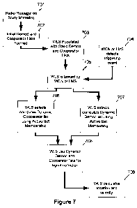
[0128] Figure 7 illustrates the generalized operation of the aggregate
methods. A
radio propagation model is created for the area 701 and the radio propagation
model is used
to determine the initial cooperator list and demod sector list for any cell in
the WLS service
area 702. The deployed wireless location system is populated with the initial
lists 703. At
some time, the WCN or the LMS signals that a location triggering event has
occurred 704,
and call-related information which includes the active set details is passed
to the WLS 705.
[0129] In some designs, the radio propagation modeling 701 may have been
performed but the generation of the initial coop and demod lists 702 may not
be performed
until after tasking information has been received. The radio propagation
modeling 701 and
generation of the initial coop and demods 702 to pre-populate the WLS 703 may
require less
computational load to be executed after tasking information has been received
and before
signal collection can begin. Similarly, in some designs both the radio
propagation modeling
701 and the generation of the initial coop and demod lists 702 may not be
performed until
after tasking information has been received. All such choices are a designer's
option.
[0130] The WLS, using the newly acquired active set details computes new
cooperator 706 and demod sector lists 707. The WLS then uses the newly
computed lists to
task the LMU network for signal collection 708. Using the reported time
differences of
arrival and/or angles of arrival, the WLS computes a final location, speed and
heading 709
with error estimates for each.
Aggregate Method 1 - Construct new cooperators in a round-robin fashion
based on octants of active set members.
[0131] This method is based on octant structures formed during coop generation
for
a single serving cell, as described above. Every active set member is
segmented into an octant
structure as though it were a single serving cell. Then, instead of spiraling
around a single
WO 2011/081999 PCT/US2010/061241
TPI-1233
site, this method iterates through the octant structures of all the active set
members while
incrementing the octant number. The net effect is to take coops from every
active set member
and a range of relative azimuths about each one.
[0132] Figure 8a and Figure 8b illustrate the use of the active set membership
in
determining the selection of potential cooperative and demod receivers and the
selection of
cooperative and demod receivers likely to provide TDOA and AoA coverage for
the mobile
device.
[0133] Figure 8a depicts a cellular network comprising base stations 801 802
803
804 805. A mobile device 806 is engaged in a soft-handoff with three sectors
810 811 812
using radio links 807 808 809. In this aggregate method, the SMLC recalls the
marker points
and associated quality metric to every other potential cooperator for the
involved cells 810
811 812. The area surrounding each of the involved cells 810 811 812 is then
segmented
using the radial octant method detailed in Figure 2c. The SMLC then
recalculates a fresh
cooperator and demod sector list by selecting the best candidate cooperators
based on the
quality metrics associated with the sectors in the current radial segment
(using eight radial
segments as in the example, each segment is one octant). Selection of the
current segment is
performed in a round-robin fashion by stepping through both the sectors and
the octants. For
example, the current involved sector may be stepped through in sequential
fashion (in Figure
8b, an acceptable sector pattern would be 810-811-812-810-811-812...) and the
octants may
be stepped through following the octant selection pattern 1-4-7-2-5-8-3-6.
Thus, for the first
24 cooperators selected the pattern of cells and octants may be as shown in
the table in Figure
8c. The octant selection pattern 1-4-7-2-5-8-3-6 is exemplary and other
selection patterns
may be used to provide geometric diversity or spatial symmetry.
[0134] Selection of a fresh set of cooperators may be continued, repeating the
selection of segments from the involved sectors and the election of yet-
unelected target
sectors to the fresh cooperative receiver list based on the best remaining
quality metric until
the target number of cooperators is reached or no more target sectors remain.
As in step 10
above, once the stopping point is reached, the power of the last LMU sector
added is
determined. The LMU sectors previously added to the cooperator list is
examined and, for
each such LMU sector, the LMU sectors not already on the cooperator list that
are connected
to an antenna and is located in close geographic proximity to its antenna and
has average path
26
WO 2011/081999 PCT/US2010/061241
TPI-1233
loss low enough to plausibly be capable of performing a baseline measurement
is added to
the cooperator list.
[0135] A fresh demod sector list is then created. All active set members
having an
LMU connected are included first in the demod sector list, before (thus at a
higher priority
than) other demod sectors. If the number of active set members having an LMU
connected is
more than the limit D from Step 11 above, the number of active set members
takes
precedence. (The value of D varies according to the network characteristics,
but generally
falls between 2 and 10). Next, all LMU sectors previously added to the demod
list are
examined and, for each such sector, LMU sectors not already on the demod list
whose
antenna is located in close geographic proximity to its antenna, regardless of
estimated path
loss, is added to the demod list. Other, lower-priority demod sectors are
selected (at lower
priority, and without duplication) in round-robin fashion from the demod
sector lists of the
individual active set members, as in the procedure detailed in Step 11 above
but following
the same round-robin pattern used for coop selection and illustrated in
Figures 8a, 8b and 8c.
[0136] This aggregate method is relatively straightforward, but may not be
optimal
because it indirectly uses the union of the coverage areas of the active set
members rather
than the intersection of those areas. Accordingly, this aggregate method may,
in some
instances, select cooperative receivers that are not optimal candidates. Due
to its simple
approach, however, this method can still be useful in situations where a large
number of
cooperative receivers must be accommodated. Like all aggregate methods, this
method has
the advantage that it incorporates information about the coverage areas of all
active set
members in the selection of cooperating receivers and demod sectors.
[0137] Aggregate method 1 is equally applicable to the construction of coop
and
demod sector lists for locating mobile units in wireless communication systems
that
incorporate distributed antenna systems (DAS). A distributed antenna system
uses multiple
antennas typically located at separate geographic sites to provide radio
coverage for a single
cell. The coverage area provided by a distributed antenna system is typically
significantly
larger than the coverage area provided by one of its component antennas.
[0138] To apply this method when there is a single serving cell and the
receive
(uplink) antenna system for that cell is a DAS, that cell's DAS component
antennas may be
substituted for the active set members of Aggregate Method 1 as though the
active set
consists of the DAS component antennas. Thus, marker points are used and the
associated
27
WO 2011/081999 PCT/US2010/061241
TPI-1233
propagation metrics are calculated for each DAS component antenna and every
LMU sector
that is connected to one of the DAS component antennas is elected as a demod
sector. If the
designer or deployer requires more demod sectors than are part of the serving
cell's DAS,
others may be selected (at lower priority, and without duplication) in round-
robin fashion
from the demod sector lists of the DAS component elements using the procedure
detailed in
Step 11 above but following the same round-robin pattern used for coop
selection and
illustrated in Figures 8a, 8b and 8c.
[0139] To apply this method when there is an active set consisting of more
than one
cell and the receive (uplink) antenna system of at least one active set member
is a DAS,
substitute for the active set members of Aggregate Method 1 the union of all
LMU sectors
associated with all the non-DAS active set members and all LMU sectors
associated with all
DAS component antennas of all the DAS active set members, as though the active
set
consists of all non-DAS active set members and the DAS components of all the
DAS active
set members. Thus, marker points are used and the associated propagation
metrics are
calculated for each non-DAS active set member and for each DAS component
antenna of any
active set member that is a DAS and every LMU sector that is connected to a
non-DAS active
set member or to one of the DAS component antennas of any active set member is
elected as
a demod sector. If the designer or deployer requires more demod sectors,
others may be taken
(at lower priority, and without duplication) in round-robin fashion from the
demod sector lists
of the DAS component elements, as in the procedure detailed in Step 11 above
but following
the same round-robin pattern used for coop selection and illustrated in
Figures 8a, 8b and 8c.
Aggregate Method 2 - Construct new cooperators list based on marker points of
active set members
[0140] This method computes new coop and demod sector lists based on the union
of the marker points associated with the active set members. In an embodiment,
the above
described aggregate method may be extended by segmenting the area surrounding
the active
set members using radial segments centered at a representative point chosen
based on
geographic information associated with the active set members. In one
embodiment, the
centroid of the geographic locations of the active set members is used. The
losses to each
candidate sector from the marker points of the active set members may be
averaged.
[0141] Figure 9a illustrates a cellular network made of base stations 901 902
903
904 905. A mobile device 906 is engaged in a soft-handoff with three cells 910
911 912 using
28
WO 2011/081999 PCT/US2010/061241
TPI-1233
radio links 907 908 909. In this aggregate method, the marker points are
recalled for all
involved cells and the quality metric between all target LMU sectors and each
marker point is
calculated. The quality metric from each marker point for each involved cell
is then averaged
so that each potential cooperator (target sector) has a single associated
overall quality metric.
[0142] A representative central point for the area covered by the active set
is then
chosen. In one embodiment, the centroid of the involved sectors is used.
Figure 9b shows the
centroid 913. The centroid is found by averaging (separately) the x and y
geographic
coordinates of the individual sector 910 911 912 receiver antennas. Alternate
methods to
select a representative central point include calculating a weighted centroid
using weights
based on a model of power or signal quality.
[0143] Once the central point 913 has been determined, the area surrounding
the
centroid 913 is radially segmented (in this example, the centroid is segmented
into octants).
While following the octant selection pattern 1-4-7-2-5-8-3-6, fresh sets of
cooperators and
demodulators are selected by, for each octant in turn, selecting the target
sector in the current
octant with the best revised quality metric. Selection of a set of cooperators
is continued by
repeating the selection of segments from the involved cells and the election
of yet unselected
target sectors to the cooperative receiver list based on best remaining
quality metrics until the
desired number of cooperators is reached or no more target sectors remain for
an octant.
Once the stopping point is reached, the power of the last sector added is
determined. The
LMU sectors previously added to the cooperator list are examined and for each
such LMU
sector, LMU sectors not already on the cooperator list that are connected to
an antenna that is
located in close geographic proximity to its antenna and has average path loss
low enough to
plausibly be capable of performing a baseline measurement are added to the
cooperator list.
[0144] A fresh demod sector list is then created. All active set members
having a
connected LMU are included first in the demod sector list, before (thus at a
higher priority
than) other demod sectors. If the number of active set members having a
connected LMU is
more than the limit D from Step 11 above, the number of active set members
takes
precedence. (The value of D varies according to the network characteristics,
but generally
falls between 2 and 10). Next, examine all LMU sectors previously added to the
demod list
and for each such sector, add to the demod list every LMU sector not already
on the demod
list whose antenna is located in close geographic proximity to its antenna,
regardless of
29
WO 2011/081999 PCT/US2010/061241
TPI-123 3
estimated path loss. Other lower-priority demod sectors are selected using the
procedure
detailed in Step 11 above, up to but not beyond the limit D.
[0145] This method is more computationally intensive in that it requires re-
computing the path losses between all the marker points and the candidate
sectors, but having
these new metrics based on the actual active set members provides a better
selection criteria
for the cooperating sectors. By selecting each LMU sector based on an estimate
of signal
quality at marker points representing the coverage areas of all active set
members, this
method has the potential to be more precise than Aggregate Method 1. Like all
aggregate
methods, the method incorporates information about the coverage areas of all
active set
members in the selection of cooperating and demodulating receivers.
Aggregate Method 3 - Construct new, cooperators based on the coverage area
common to all active set members.
[0146] This method constructs new cooperative and demod receivers based on
predicting a common coverage area of all active set members. A new set of
marker points is
selected to represent the intersecting coverage area. A representative central
point for the
intersecting coverage area is selected and the octant structure is placed at
the central point.
The octant structure is populated based on averaging the signal losses from
these new marker
points to each candidate sector. The above described spiral algorithm is then
used to select
the cooperative receivers and demod sectors.
[0147] As shown in Figure 10a, by using a bounding polygon to approximate the
sector coverage area for each involved cell, a bounding polygon is created
that fully
encompasses the geographic area that the involved cell serves.
[0148] First, the geographic area that falls into the bounding polygon of
every
involved sector is determined. In Figure 1 Oa, the area of geographic overlap
1016 is
determined by the bounding polygons (depicted in Figure 1 Oa as rectangles for
ease of
depiction). The wireless communications network is depicted by the five
sectored cells 1001
1002 1003 1004 1005. The bounding rectangles 1010 1011 1012 are sized so as to
encompass
the entire area of useful radio coverage provided by the involved sectors 1013
1014 1015.
The radio links 1007 1008 1009 between the involved sectors 1013 1014 1015 and
the
wireless device 1006 are shown.
[0149] Once the area of overlap 1016 is determined, a set of h geographically
distributed marker points is created. For each of the fresh marker points 1-to-
h, the radio
WO 2011/081999 PCT/US2010/061241
TPI-1233
propagation model is used to determine a quality metric to every target sector
within range.
The range is adjustable and dependent on the network topology. The range may
be expressed
as a distance or as a number of cell radii.
[01501 Once a fresh quality metric to every target sector within range for
each fresh
marker point is generated, the quality metrics from each fresh marker point
within the area of
overlap 1016 are averaged to create a single quality metric for each target
sector. As shown in
Figure l Ob, the centroid 1017 of the area of overlap 1016 is calculated and
the geographic
area surrounding the centroid 1017 is radially segmented (in this example,
segmentation is
again into octants). The radially segmented sections 1-8 are as shown in
figure 10b, centered
on the centroid 1017 of the area of overlap 1016 as calculated from the
bounding polygons
1010 1011 1012 derived from the useful radio coverage areas of the involved
sectors 1013
1014 1015. Following the octant selection pattern 1-4-7-2-5-8-3-6, a fresh set
of cooperator
and demod sectors are selected by, for each octant in turn, selecting the
target sector in the
current octant with the best fresh quality metric. Selection of an updated set
of cooperators is
continued, repeating the selection of segments from the involved cells and the
election of yet
unselected target sectors to the fresh cooperative receiver list based on best
remaining quality
metric until the desired number of cooperators is reached or no more target
sectors remain.
Once the stopping point is reached, the power of the last sector added is
determined. The
LMU sectors previously added to the cooperator list are examined and for each
such LMU
sector, LMU sectors that are not already on the cooperator list connected to
an antenna that is
located in close geographic proximity to its antenna and has average path loss
low enough to
plausibly be capable of performing a baseline measurement are added to the
cooperator list.
[01511 A fresh demod sector list is then created. All active set members
having a
connected LMU are included first in the demod sector list, before (thus at a
higher priority
than) other demod sectors. If the number of active set members having a
connected LMU is
more than the limit D from Step 11 above, the number of active set members
takes
precedence. (The value of D varies according to the network characteristics,
but generally
falls between 2 and 10). Next, examine all LMU sectors previously added to the
demod list
and for each such sector, add to the demod list every LMU sector not already
on the demod
list whose antenna is located in close geographic proximity to its antenna,
regardless of
estimated path loss. Other lower-priority demod sectors are selected using the
procedure
detailed in Step 11 above, up to but not beyond the limit D.
31
WO 2011/081999 PCT/US2010/061241
TPI-123 3
[01521 This method (and Proxy Method 3) assumes the determination of useful
bounds for sector coverage areas. If the bounds are too loose (meaning that
the polygons are
larger than necessary), the coop and demod sector selection suffer some loss
of precision. If
the bounds are too tight, the determination of an intersection may not be
possible. A number
of techniques may be used to strike a balance between determining bounding
polygons that
provide an intersection/overlap and yet not making the polygons so large that
the results are
no longer useful). Such techniques include: 1) allowing more complex polygon
shapes and/or
2) using multiple intersecting contours encompassing, e.g., 50%, 70%, or 95%
coverage
areas, and analyzing the intersection areas to obtain a compact intersection
polygon that
encloses the likely mobile location. For cases in which a representative
intersection cannot be
found, other methods may be used for fallback purposes.
[01531 Aggregate Method 3 incorporates the additional step of estimating the
coverage area of each cell and finding the intersection of those areas. Once
that step is taken,
this method has the advantage of requiring fewer path loss calculations as
they are made from
a smaller set of marker points than the union of all the marker points. The
resulting metrics
may also provide better selection criteria for cooperative receivers because
they are computed
from a better estimate of the likely location of the mobile device (the
intersection of the
coverage areas, rather than the union). This method is more complicated
compared to
Aggregate Method 2 above but provides a closer to optimal representation of
Active Set
coverage. The trade-off is between computational complexity and potential
impacts to
location latency vs. location accuracy.
D. Conclusion
[01541 The use of mobile generated radio quality information as expressed by
the
generation of the Active Set for CDMA-based wireless communications system
represents a
distinct improvement over other methods. Use of the disclosed techniques allow
for location
accuracy improvement without any drive test effort. The participating WLS
receiver sites are
selected in real time based upon real RF channel conditions (taking into
account fading,
temporary blocking, etc.) and system throughput is not impacted by over-
selection of receiver
sites in an attempt to improve accuracy.
[01551 The true scope the present invention is not limited to the presently
preferred
embodiments disclosed herein. For example, the foregoing disclosure of a
presently preferred
embodiment of a Wireless Location System uses explanatory terms, such as
Serving Mobile
32
WO 2011/081999 PCT/US2010/061241
TPI-1233
Location Centers (SMLC), Location Measuring Unit (LMU), and the like, which
should not
be construed so as to limit the scope of protection of the following claims,
or to otherwise
imply that the inventive aspects of the Wireless Location System are limited
to the particular
methods and apparatus disclosed. Moreover, as will be understood by those
skilled in the art,
many of the inventive aspects disclosed herein may be applied in location
systems that are
not based on TDOA or AoA techniques. The LMU's, etc. are, in essence,
programmable data
collection and processing devices that could take a variety of forms without
departing from
the inventive concepts disclosed herein. Given the rapidly declining cost of
digital signal
processing and other processing functions, it is easily possible, for example,
to transfer the
processing for a particular function from one of the functional elements (such
as the SMLC)
described herein to another functional element (such as the LMU) without
changing the
inventive operation of the system. In many.cases, the place of implementation
(i.e., the
functional element) described herein is merely a designer's preference and not
a hard
requirement. Accordingly, except as they may be expressly so limited, the
scope of protection
of the following claims is not intended to be limited to the specific
embodiments described
above.
[0156] Any of the above mentioned aspects can be implemented in methods,
systems, computer readable media, or any type of manufacture. It should be
understood to
those skilled in the art that the various techniques described herein may be
implemented in
connection with hardware or software or, where appropriate, with a combination
of both. For
example, aspects of the invention may execute on a programmed computer. Thus,
the
methods and apparatus of the invention, or certain aspects or portions
thereof, may take the
form of program code (i.e., instructions) embodied in tangible media, such as
floppy
diskettes, CD-ROMs, hard drives, or any other machine-readable storage medium
wherein,
when the program code is loaded into and executed by a machine, such as a
computer, the
machine becomes an apparatus for practicing the invention. In the case of
program code
execution on programmable computers, the computing device generally includes a
processor,
a storage medium readable by the processor (including volatile and non-
volatile memory
and/or storage elements), at least one input device, and at least one output
device. One or
more programs that may implement or utilize the processes described in
connection with the
invention, e.g., through the use of an API, reusable controls, or the like.
Such programs are
preferably implemented in a high level procedural or object oriented
programming language
33
WO 2011/081999 PCT/US2010/061241
TPI-1233
to communicate with a computer system. However, the program(s) can be
implemented in
assembly or machine language, if desired. In any case, the language may be a
compiled or
interpreted language, and combined with hardware implementations. In example
embodiments a computer readable storage media can include for example, random
access
memory (RAM), a storage device, e.g., electromechanical hard drive, solid
state hard drive,
etc., firmware, e.g., FLASH RAM or ROM, and removable storage devices such as,
for
example, CD-ROMs, floppy disks, DVDs, FLASH drives, external storage devices,
etc. It
should be appreciated by those skilled in the art that other types of computer
readable storage
media can be used such as magnetic cassettes, flash memory cards, digital
video disks,
Bernoulli cartridges, and the like. The computer readable storage media may
provide non-
volatile storage of processor executable instructions, data structures,
program modules and
other data for a computer.
[0157] Lastly, while the present disclosure has been described in connection
with
the preferred aspects, as illustrated in the various figures, it is understood
that other similar
aspects may be used or modifications and additions may be made to the
described aspects for
performing the same function of the present disclosure without deviating
therefrom. For
example, in various aspects of the disclosure, various mechanisms were
disclosed for tracking
a subject associated with a mobile device. However, other equivalent
mechanisms to these
described aspects are also contemplated by the teachings herein. Therefore,
the present
disclosure should not be limited to any single aspect, but rather construed in
breadth and
scope in accordance with the appended claims.
34