Note : Les descriptions sont présentées dans la langue officielle dans laquelle elles ont été soumises.
CA 02796923 2012-10-19
WO 2011/152917 PCT/US2011/028795
DETERMINING LANDING SITES FOR AIRCRAFT
BACKGROUND
100011 The present disclosure relates generally to aviation of aircraft and,
more
particularly, to systems and methods for determining landing sites for
aircraft.
100021 In-flight emergencies that result in off-airport landings can result in
the loss of life
and property. The problem of selecting a suitable emergency landing site is a
complex
problem that has been exacerbated by the continued development of previously
undeveloped, underdeveloped, and/or unoccupied areas.
During an in-flight
emergency, pilots have been limited to using their planning, experience,
vision, and
familiarity with a given area to select an emergency landing site.
100031 During an emergency condition, a pilot may have little time to
determine that an
emergency landing needs to be executed, to find or select a suitable landing
site, to
execute other aircraft emergency procedures, to prepare passengers, and to
then pilot
the aircraft to the selected landing site. Thus, management of an in-flight
emergency
requires timely and accurate decision making processes to protect not only
lives
onboard the aircraft, but also to protect lives and property on the ground and
to prevent
a complete loss of the aircraft.
100041 It is with respect to these and other considerations that the
disclosure made
herein is presented.
SUMMARY
100051 It should be appreciated that this Summary is provided to introduce a
selection
of concepts in a simplified form that are further described below in the
Detailed
Description. This Summary is not intended to be used to limit the scope of the
claimed
subject matter.
100061 According to an embodiment of the present disclosure, a method for
determining
a landing site for an aircraft includes receiving flight data corresponding to
a flight path.
The method further can include identifying at least one landing site proximate
to the
flight path, generating a spanning tree between the at least one landing site
and the
flight path, and storing the spanning tree in a data storage device. According
to some
embodiments, the landing sites are determined in real-time. Additionally, the
landing
sites may be determined at the aircraft or at a remote system or device in
communication with the aircraft.
1
[0007] According to another embodiment, a routing tool for determining a
landing site
for an aircraft includes a database configured to store flight data
corresponding to a flight
path for the aircraft, and a routing module. The routing module is configured
to receive
the flight data, identify at least one landing site proximate to the flight
path, generate a
spanning tree between the at least one landing site and the flight path, and
store the
spanning tree in a data storage device.
[0008] According to another embodiment, a computer readable storage
medium is
disclosed. The computer readable medium has computer executable instructions
stored
thereon, the execution of which by a processor make a routing tool operative
to receive
flight data corresponding to a flight path, identify at least one landing site
proximate to the
flight path, generate a spanning tree between the at least one landing site
and the flight
path, store the spanning tree in a data storage device, detect an emergency at
the aircraft
during a flight of the aircraft, and in response to detecting the emergency,
display the
spanning tree for selection of a landing site.
[0008a] According to another embodiment, a method comprises: receiving, by a
routing
.. tool, flight data corresponding to a flight path; identifying, by the
routing tool, a plurality of
landing sites proximate to the flight path; generating, by the routing tool, a
plurality of
spanning trees, each spanning tree between a landing site of the plurality of
landing sites
and the flight path; storing each spanning tree in a data storage device;
displaying at least
one spanning tree of the plurality of spanning trees and a landing site
associated with the
displayed spanning tree; and displaying a countdown timer with the spanning
tree, the
countdown timer indicating an amount of time by which the displayed landing
site may be
selected.
[0008b] According to another embodiment, a routing tool comprises a database
configured to store flight data corresponding to a flight path for an
aircraft, and a routing
module configured to: receive the flight data; identify a plurality of landing
sites proximate
to the flight path; generate a plurality of spanning trees, each spanning tree
between a
landing site of the plurality of landing sites and the flight path; store each
spanning tree in
a data storage device; display at least one spanning tree of the plurality of
spanning trees
and a landing site associated with the displayed spanning tree; and display a
countdown
timer with the spanning tree, the countdown timer indicating an amount of time
by which
the displayed landing site may be selected.
2
CA 2796923 2018-03-26
[0008c] According to another embodiment, a computer readable storage medium
has
computer executable instructions stored thereon, the execution of which by at
least one
processor, cause a routing tool to: receive flight data corresponding to a
flight path;
identify a plurality of landing sites proximate to the flight path; generate a
plurality of
spanning trees, each spanning tree between a landing site of the plurality of
landing sites
and the flight path; store each spanning tree in a data storage device; detect
an
emergency at the aircraft during a flight of the aircraft; in response to
detecting the
emergency, display at least one spanning tree of the plurality of spanning
trees and a
landing site of the plurality of landing sites associated with the displayed
spanning tree;
and display a countdown timer indicating an amount of time by which the
displayed
landing site may be selected.
[0008d] According to another embodiment, a computer-implemented method for
generating safe ingress flight paths to an identified landing site for an
aircraft, comprises:
generating, by at least one processor, a spanning tree for the identified
landing site by:
producing a plurality of possible approach paths by starting at a touchdown
point on the
identified landing site and building each of the plurality of possible
approach paths from
the touchdown point outward while minimizing altitude changes while moving
away from
the touchdown point, identifying obstructions proximate the identified landing
site, and
eliminating any obstructed possible approach paths of the plurality of
possible approach
paths that conflict with the obstructions to produce a plurality of allowed
approach paths
to the touchdown point; storing, in a data storage device, the spanning tree
including the
allowed approach paths; providing information from the spanning tree in the
data storage
device to an in-flight display for use by aircraft personnel; and providing a
countdown
timer with each of the plurality of allowed approach paths indicating a time
by which each
allowed approach path remains available as an option for the identified
landing site.
2a
CA 2796923 2018-03-26
[0008e] According to another embodiment, a routing tool for generating safe
ingress
flight paths to an identified landing site for an aircraft, comprises a
database configured to
store flight data corresponding to a flight path for the aircraft, and a
routing module
configured to: generate a spanning tree for the identified landing site by:
producing a
plurality of possible approach paths by starting at a touchdown point on the
identified
landing site and building each of the plurality of possible approach paths
from the
touchdown point outward while minimizing altitude changes while moving away
from the
touchdown point, identifying obstructions proximate the identified landing
site, and
eliminating any obstructed possible approach paths of the plurality of
possible approach
paths that conflict with the obstructions to produce a plurality of allowed
approach paths
to the touchdown point; store, in a data storage device, the spanning tree
including the
allowed approach paths; provide information from the spanning tree in the data
storage
device to an in-flight display for use by aircraft personnel; and provide a
countdown timer
with each of the plurality of allowed approach paths indicating a time by
which the allowed
approach path remains available as an option for the identified landing site.
[00081 According to another embodiment, a non-transitory computer readable
storage
medium having computer executable instructions stored thereon, the execution
of which
by at least one processor, cause a routing tool to: generate a spanning tree
for an
identified landing site by: producing a plurality of possible approach flight
paths by starting
at a touchdown point on the identified landing site and building each of the
plurality of
possible approach paths from the touchdown point outward while minimizing
altitude
changes while moving away from the touchdown point, identifying obstructions
proximate
the identified landing site, and eliminating any obstructed possible approach
paths of the
plurality of possible approach paths that conflict with the obstructions to
produce a
plurality of allowed approach paths to the touchdown point; store, in a data
storage
device, the spanning tree including the allowed approach paths; provide
information from
the spanning tree in the data storage device to an in-flight display for use
by aircraft
personnel, display a vertical profile view of a glide path for approach to the
identified at
least one landing site that includes current aircraft position; and provide a
countdown
timer with each of the plurality of allowed approach paths indicating a time
by which the
allowed approach path remains available as an option for the identified
landing site.
2b
CA 2796923 2018-03-26
[0009] The features, functions, and advantages discussed herein can be
achieved
independently in various embodiments of the present invention or may be
combined in
yet other embodiments, further details of which can be seen with reference to
the
following description and drawings.
BRIEF DESCRIPTION OF THE DRAWINGS
[0010] FIGURE 1 schematically illustrates a block diagram of a routing
tool, according
to an exemplary embodiment.
[0011] FIGURE 2A illustrates an exemplary landing site display, according
to an
exemplary embodiment.
[0012] FIGURE 2B illustrates an exemplary glide profile view display,
according to an
exemplary embodiment.
[0013] FIGURE 3A illustrates a screen display for an exemplary embodiment
of the
moving map display.
[0014] FIGURE 3B illustrates an exemplary glide profile view display,
according to an
exemplary embodiment.
[0015] FIGURE 4 illustrates a map display generated by the routing tool,
according to
an exemplary embodiment.
2c
CA 2796923 2018-03-26
CA 02796923 2012-10-19
WO 2011/152917 PCT/US2011/028795
100161 FIGURES 5A-58 illustrate landing site maps, according to exemplary
embodiments.
100171 FIGURES 6A-6B schematically illustrate flight path planning methods,
according
to exemplary embodiments.
100181 FIGURES 7A-7B illustrate additional details of the routing tool,
according to
exemplary embodiments.
100191 FIGURE 8 illustrates the application of turn constraints in an update
phase of the
path planning algorithm, according to an exemplary embodiment.
100201 FIGURE 9 shows a routine for determining landing sites for aircraft,
according to
an exemplary embodiment.
100211 FIGURES 10A-1013 illustrate screen displays provided by a graphical
user
interface (GUI) for the routing tool, according to exemplary embodiments.
100221 FIGURE 11 shows an illustrative computer architecture of a routing
tool,
according to an exemplary embodiment.
DETAILED DESCRIPTION
100231 The following detailed description is directed to systems, methods, and
computer
readable media for determining landing sites for aircraft. Utilizing the
concepts and
technologies described herein, routing methodologies and a routing tool may be
implemented for identifying attainable landing sites within a dead stick or
glide footprint
for the aircraft. The identified attainable landing sites may include airport
landing sites
and off-airport landing sites.
100241 According to embodiments described herein, the attainable landing sites
are
evaluated to allow identification and/or selection of a recommended or
preferred landing
site. In particular, the evaluation of the landing sites may begin with a data
collection
operation, wherein landing site data relating to the attainable landing sites
and/or
aircraft data relating to aircraft position and performance are collected. The
landing site
data may include, but is not limited to, obstacle data, terrain data, weather
data, traffic
data, population data, and other data, all of which may be used to determine a
safe
ingress flight path for each identified landing site. The aircraft data may
include, but is
not limited to, global positioning system (GPS) data, altitude, orientation,
and airspeed
data, glide profile data, aircraft performance data, and other information.
3
CA 02796923 2012-10-19
WO 2011/152917 PCT/US2011/028795
100251 In some embodiments, a flight path spanning tree is generated for safe
ingress
flight paths to the determined attainable landing sites. The flight path
spanning tree is
generated from the landing site and is backed into the flight path. In some
embodiments, the spanning trees are generated before or during flight, and can
take
into account a planned or current flight path, a known or anticipated glide
footprint for
the aircraft, banking opportunities, and detailed flight-time information. In
some
embodiments, the spanning trees can be accompanied by an optional countdown
timer
for each displayed branch of the spanning tree, i.e., each flight path to a
landing site,
the countdown timer being configured to provide a user with an indication as
to how
long the associated flight path remains available as a safe ingress option for
the
associated landing site.
100261 According to various embodiments, collecting data, analyzing the data,
identifying possible landing sites, generating spanning trees for each
identified landing
site, and selecting a landing site may be performed during a flight planning
process, in-
flight, and/or in real-time aboard the aircraft or off-board. Thus, in some
embodiments
aircraft personnel are able to involve Air Traffic Control (ATC), Airborne
Operations
Centers (A0Cs), and/or Air Route Traffic Control Centers (ARTCCs) in the
identification, analysis, and/or selection of suitable landing sites. The ATC,
AOCs,
and/or ARTCCs may be configured to monitor and/or control an aircraft involved
in an
emergency situation, if desired. These and other advantages and features will
become
apparent from the description of the various embodiments below.
100271 Throughout this disclosure, embodiments are described with respect to
manned
aircraft and ground-based landing sites. While manned aircraft and ground-
based
landing sites provide useful examples for embodiments described herein, these
examples should not be construed as being limiting in any way. Rather, it
should be
understood that some concepts and technologies presented herein also may be
employed by unmanned aircraft as well as other vehicles including spacecraft,
helicopters, gliders, boats, and other vehicles. Furthermore, the concepts and
technologies presented herein may be used to identify non-ground-based landing
sites
such as, for example, a landing deck of an aircraft carrier.
100281 In the following detailed description, references are made to the
accompanying
drawings that form a part hereof and that show, by way of illustration,
specific
4
CA 02796923 2012-10-19
WO 2011/152917 PCT/US2011/028795
embodiments or examples. In referring to the drawings, like numerals represent
like
elements throughout the several figures.
[00291 FIGURE 1 schematically illustrates a block diagram of a routing tool
100,
according to an exemplary embodiment. The routing tool 100 can be embodied in
a
computer system such as an electronic flight bag (EFB); a personal computer
(PC); a
portable computing device such as a notepad, netbook or tablet computing
device;
and/or across one or more computing devices, for example, one or more servers
and/or
web-based systems. As mentioned above, some, none, or all of the functionality
and/or
components of the routing tool 100 can be provided by onboard systems of the
aircraft
or by systems located off-board.
100301 The routing tool 100 includes a routing module 102 configured to
provide the
functionality described herein including, but not limited to, identifying,
analyzing, and
selecting a safe landing site. It should be understood that the functionality
of the routing
module 102 may be provided by other hardware and/or software instead of, or in
addition to, the routing module 102. Thus, while the functionality described
herein
primarily is described as being provided by the routing module 102 , it should
be
understood that some or all of the functionality described herein may be
performed by
one or more devices other than, or in addition to, the routing module 102.
100311 The routing tool 100 further includes one or more databases 104. While
the
databases 104 are illustrated as a unitary element, it should be understood
that the
routing tool 100 can include a number of databases. Similarly, the databases
104 can
include a memory or other storage device associated with or in communication
with the
routing tool 100, and can be configured to store a variety of data used by the
routing
tool 100. In the illustrated embodiment, the databases 104 store terrain data
106,
airspace data 108, weather data 110, vegetation data 112, transportation
infrastructure
data 114, populated areas data 116, obstructions data 118, utilities data 120,
and/or
other data (not illustrated).
100321 The terrain data 106 represents terrain at a landing site, as well as
along a flight
path to the landing site. As will be explained herein in more detail, the
terrain data 106
can be used to identify a safe ingress path to a landing site, taking into
account terrain,
e.g., mountains, hills, canyons, rivers, and the like. The airspace data 108
can indicate
airspace that is available for generating one or more flight paths to the
landing sites.
5
CA 02796923 2012-10-19
WO 2011/152917 PCT/US2011/028795
The airspace data 108 could indicate, for example, a military installation or
other
sensitive area over which the aircraft cannot legally fly.
100331 The weather data 110 can include data indicating weather information,
particularly historical weather information, trends, and the like at the
landing site, as well
as along a flight path to the landing site. The vegetation data 112 can
include data
indicating the location, height, density, and other aspects of vegetation at
the landing
site, as well as along a flight path to the landing site, and can relate to
various natural
obstructions including, but not limited to, trees, bushes, vines, and the
like, as well as
the absence thereof. For example, a large field may appear to be a safe
landing site,
but the vegetation data 112 may indicate that the field is an orchard, which
may
preclude usage of the field for a safe landing.
100341 The transportation infrastructure data 114 indicates locations of
roads,
waterways, rails, airports, and other transportation and transportation
infrastructure
information. The transportation infrastructure data 114 can be used to
identify a nearest
airport, for example. This example is illustrative, and should not be
construed as being
limiting in any way. The populated areas data 116 indicates population
information
associated with various locations, for example, a landing site and/or areas
along a flight
path to the landing site. The populated areas data 116 may be important when
considering a landing site as lives on the ground can be taken into account
during the
decision process.
100351 The obstructions data 118 can indicate obstructions at or around the
landing site,
as well as obstructions along a flight path to the landing site. In some
embodiments, the
obstructions data include data indicating manmade obstructions such as power
lines,
cellular telephone towers, television transmitter towers, radio towers, power
plants,
stadiums, buildings, and other structures that could obstruct a flight path to
the landing
site. The utilities data 120 can include data indicating any utilities at the
landing site, as
well as along a flight path to the landing site. The utilities data 120 can
indicate, for
example, the locations, size, and height of gas pipelines, power lines, high-
tension
wires, power stations, and the like.
100361 The other data can include data relating to pedestrian, vehicle, and
aircraft traffic
at the landing sites and along a flight path to the landing sites; ground
access to and
from the landing sites; distance from medical resources; combinations thereof;
and the
like. Furthermore, in some embodiments, the other data stores flight plans
submitted by
6
CA 02796923 2012-10-19
WO 2011/152917 PCT/US2011/028795
a pilot or other aircraft personnel. It should be understood that the flight
plans may be
submitted to other entities, and therefore may be stored at other locations
instead of, or
in addition to, the databases 104.
100371 The routing tool 100 also can include one or more real-time data
sources 122.
The real-time data sources 122 can include data generated in real-time or near-
real-
time by various sensors and systems of or in communication with the aircraft.
In the
illustrated embodiment, the real-time data sources include real-time weather
data 124,
GPS data 126, ownship data 128, and other data 130.
100381 The real-time weather data 124 includes real-time or near-real-time
data
indicating weather conditions at the aircraft, at one or more landing sites,
and along
flight paths terminating at the one or more landing sites. The GPS data 126
provides
real-time or near-real-time positioning information for the aircraft, as is
generally known.
The ownship data 128 includes real-time navigational data such as heading,
speed,
altitude, trajectory, pitch, yaw, roll, and the like. The ownship data 128 may
be updated
almost constantly such that in the event of an engine or other system failure,
the routing
module 102 can determine and/or analyze the aircraft trajectory. The ownship
data 128
further can include real-time or near-real-time data collected from various
sensors
and/or systems of the aircraft and can indicate airspeed, altitude, attitude,
flaps and
gear indications, fuel level and flow, heading, system status, warnings and
indicators,
and the like, some, all, or none of which may be relevant to identifying,
analyzing,
and/or selecting a landing site as described herein. The other data 130 can
include, for
example, data indicating aircraft traffic at or near a landing site, as well
as along a flight
path to the landing site, real-time airport traffic information, and the like.
100391 The routing tool 100 also can include a performance learning system 132
(PLS).
The PLS 132 also may include a processor (not illustrated) for executing
software to
provide the functionality of the PLS 132. In operation, the processor uses
aircraft-
performance algorithms to generate an aircraft performance model 134 from
flight
maneuvers. In some embodiments, the PLS 132 is configured to execute a model
generation cycle during which the performance model 134 is determined and
stored.
The model generation cycle can begin with execution of one or more maneuvers,
during
which data from one or more sensors on or in communication with the aircraft
can be
recorded. The recorded data may be evaluated to generate the aircraft
performance
model 134, which can then represent, for example, glide paths of the aircraft
under
7
CA 02796923 2012-10-19
WO 2011/152917 PCT/US2011/028795
particular circumstances, fuel consumption during maneuvers, change in speed
or
altitude during maneuvers, other performance characteristics, combinations
thereof, and
the like. In some embodiments, the performance model 134 is continually or
periodically updated. As will be explained in more detail below, the
performance model
134 may be used to allow a more accurate evaluation of landing sites as the
evaluation
can be based upon actual aircraft performance data, as opposed to assumptions
based
upon current operating parameters and the like.
[0040j During operation of the aircraft, data retrieved from the databases
104, data
retrieved from the real-time data sources 122, and/or the aircraft performance
model
134 can be used by the routing tool 100 to provide multiple layers of data on
an in-flight
display 136 of the aircraft. The in-flight display 136 may include any
suitable display of
the aircraft such as, for example, a display of the EFB, an NAV, a primary
flight display
(PFD), a heads up display (HUD), or a multifunction display unit (MDU), an in-
flight
display 136 for use by aircraft personnel. Additionally, or alternatively, the
data can be
passed to the routing module 102 and/or to off-board personnel and systems, to
identify
safe landing sites, to analyze the safe landing sites, and to select a landing
site and a
flight path to the safe landing sites. In some embodiments, the landing site
and flight
path information can be passed to the in-flight display 136 or another
display. As will be
described below, the in-flight display 136 or another display can provide a
moving map
display for mapping the landing sites and flight paths thereto, displaying
glide profile
views, weather, obstructions, time remaining to follow a desired flight path,
and/or other
data to allow determinations to be made by aircraft personnel. Additionally,
as
mentioned above, the data can be transmitted to off-board personnel and/or
systems.
100411 Turning now to FIGURE 2A, additional details of the routing tool 100
are
provided, according to an exemplary embodiment. FIGURE 2A illustrates an
exemplary
landing site display 200, which can be generated by the routing tool 100. The
landing
site display 200 includes a landing site 202, and an area surrounding the
landing site
202. The size of the landing site display 200 can be adjusted based upon data
included
in the display 200 and/or preferences. The landing site 202 can include an
airport
runway, a field, a highway, and/or another suitable airport or off-airport
site. In the
illustrated embodiment, the landing site 202 is illustrated within a landing
zone grid 204,
which graphically represents the distance needed on the ground to safely land
the
aircraft.
8
CA 02796923 2012-10-19
WO 2011/152917 PCT/US2011/028795
100421 The illustrated landing site 202 is bordered on at least three sides
with
obstructions that prevent a safe ingress by the aircraft. In particular, an
area of tall
vegetation 206, e.g., trees, borders the landing site 202 on the south and
east sides,
preventing the aircraft from approaching the landing site 202 from the south
or east.
Additionally. buildings 208 and power lines 210 border the landing site 202
along the
west side and northwest sides. These manmade and naturally occurring features
limit
the possible approach paths for the aircraft. As illustrated, a spanning tree
showing
allowed ingress flight paths 212A-0 are shown. In the illustrated embodiment,
the
aircraft can land at the landing site 202 only by approaching via flight paths
212A-G,
while flight paths 212H-C) are obstructed. The generation and use of spanning
trees
such as the spanning tree illustrated in FIGURE 2A will be described in more
detail
below.
100431 FIGURE 2B illustrates an exemplary glide profile view display 220,
according to
an exemplary embodiment. In some embodiments, the glide profile view display
220 is
generated by the routing tool 100 and displayed with the landing site display
200 to
indicate a glide profile 222 required to be met or exceeded by an aircraft in
order to
successfully and safely land at the landing site 202. The glide path 222 is
plotted as an
altitude versus horizontal distance traveled along the path. The glide profile
view
display 220 includes an indication 224 of the current aircraft position. As
illustrated in
FIGURE 2B, the aircraft currently has more than sufficient altitude to reach
the landing
site 202. In fact, in the illustrated embodiment, the aircraft is illustrated
as being about
nine hundred feet above the minimum altitude glide profile. Thus, the pilot of
the aircraft
will need to descend relatively quickly to successfully execute the landing.
This
example is illustrative, and is provided for purposes of illustrating the
concepts disclosed
herein.
100441 Turning now to FIGURES 3A-3B, exemplary screen displays are illustrated
according to exemplary embodiments. In particular, FIGURE 3A illustrates a
screen
display 300 for an exemplary embodiment of the moving map display. The screen
display 300 can be displayed on the in-flight display 136, a computer display
of an
onboard computer system, a display of an off-board computer system, or another
display. The screen display 300 illustrates a current position 302 of an
aircraft that is
about to make an unplanned landing, e.g., an emergency landing. The routing
tool 100
identifies two candidate landing sites 304A, 3048. Additionally, the routing
tool 100
9
CA 02796923 2012-10-19
WO 2011/152917 PCT/US2011/028795
.. determines, based upon any of the data described above, ingress paths 306A,
3068 for
the landing sites 304A-B. In the illustrated embodiment, the ingress path 306A
is a
preferred ingress path as it leads to the preferred landing site 304A, and the
ingress pat
3068 is a secondary ingress path as it leads to the secondary landing site
3048. This
embodiment is exemplary.
100451 The ingress paths 306A-B take into account any of the data described
herein
including, but not limited to, the data stored at the database 104.
Additionally, the
routing tool 100 is configured to access the real-time data sources 122, and
can display
time indications 308A, 308B, which indicate a time remaining by which the
aircraft must
commit to the respective ingress path 306A, 306B in order to safely follow the
proposed
.. route. In FIGURE 3A, the time indications 308A, 3083 are displayed as
numbers over
respective landing sites. In the illustrated embodiment, the numbers
correspond to
numbers of seconds remaining for the aircraft to commit to the associated
landing sites
304A, 304B and ingress paths 306A, 3068 and still make a safe landing. Thus,
the
numbers represent a number of seconds left before the ingress paths 306A-B are
.. invalid, assuming the aircraft remains on a course substantially equivalent
to its current
course. In FIGURE 3A, the recommended route 306A remains available for 85
seconds, while the second route 306B remains available for 62 seconds, i.e.,
23
seconds less than the recommended route 306A.
100461 Additionally displayed on the screen display 300 are weather
indications 310A,
3108, corresponding to weather at the landing sites 304A, 3048, respectively.
The
weather indications 310A-8 correspond to overcast skies at the landing site
304A, and
clear skies at the landing site 3048. These indications are exemplary, and
should not
be construed as being limiting in any way. The weather at prospective landing
sites
304A-B may be important information, as good visibility is often vital in an
emergency
.. landing situation. Similarly, certain weather conditions such as high
winds, turbulence,
thunderstorms, hail, and the like can put additional stress on the aircraft
and/or the pilot,
thereby complicating landing of what may be an already crippled aircraft.
100471 Turning now to FIGURE 3B, a glide profile view display 320 is
illustrated,
according to an exemplary embodiment. As explained above with reference to
FIGURE
.. 28, the routing tool 100 can be configured to provide the glide profile
view display 320
with the moving map display 300 to provide aircraft or other personnel with a
better
understanding of the available options. The glide profile view display 320
includes a
CA 02796923 2012-10-19
WO 2011/152917 PCT/US2011/028795
current aircraft position indicator 322. Also illustrated on the glide profile
view display
320 are representations 324A, 3248 of glide paths needed to successfully
ingress to
the landing sites 304A, 304B of FIGURE 3A. The representations 324A, 3248
("glide
paths") correspond, respectively, to the ingress paths 306A, 306B of FIGURE
3A, and
show the altitude needed to arrive safely at the landing sites 304A. 304B,
respectively.
As shown in FIGURE 38, the aircraft currently has sufficient altitude to
approach both
landing sites 304A-B.
[0048j The glide profile view display 320 allows the pilot to instantaneously
visualize
where the aircraft is with respect to the available landing sites 304A-B
and/or ingress
paths 306A-8 in the vertical (altitude) plane. Thus, the routing module 102
allows the
pilot to more quickly evaluate the potential landing sites 306A-B by
continuously
displaying the aircraft's vertical position above or below the approach path
to each site.
This allows at-a-glance analysis of landing site feasibility and relative
merit.
[00491 The glide profile view display 320 can be an active or dynamic display.
For
example, the glide profile view display 320 can be frequently updated, for
example,
every second, 5 seconds, 10 seconds, 1 minute, 5 minutes, or the like.
Potential
landing sites 304A-8 that are available given the aircraft's position and
altitude can be
added to and/or removed from the glide profile view display 320 as the
aircraft proceeds
along its flight path. Thus, if an emergency situation or other need to land
arises, the
pilot can evaluate nearby landing sites 306A-8 and choose from the currently
available
glide paths 324A-B, which are continuously calculated and updated. In some
embodiments, the descent glide 324A-B are updated and/or calculated from a
database
loaded during a flight planning exercise.
100501 The aircraft's current flight path can be connected to the best
available ingress
path 306A-8 by propagating the aircraft to align in position and heading to
the best
ingress path 306A or 3068. In the illustrated embodiment, the secondary or
alternate
route 3068 requires more energy than the energy required for the preferred
route 306A.
In the case of an aircraft that is gliding dead stick, the alternate route
306B requires that
the aircraft must start at a higher altitude than the altitude required for
aircraft to glide
along the preferred route 306A.
100511 Turning now to FIGURE 4, additional details of the routing tool are
illustrated,
according to an exemplary embodiment. FIGURE 4 shows map display 400 generated
by the routing tool 100, according to an exemplary embodiment. The map display
400
11
CA 02796923 2012-10-19
WO 2011/152917 PCT/US2011/028795
includes three possible landing sites 402A, 4028, 402C that may be chosen
during an
emergency situation, such as, for example, an in-flight fire, an engine
failure, a critical
systems failure, a medical emergency, a hijacking, or any other situation in
which an
expeditious landing is warranted.
100521 The map display 400 graphically illustrates obstructions and features
that may be
important when considering an emergency landing at a potential landing site
402A-C.
The illustrated map display 400 shows golf courses 404A, 404B, bodies of water
406A,
4068, fields 408A, 4088, and other obstructions 410 such as power lines,
bridges, ferry
routes, buildings, towers, population centers, and the like.
In the illustrated
embodiment, the potential landing sites 402A-C are airports. As is generally
known, a
landing zone for an airport has constraints on how and where touchdown can
occur. In
particular, if an aircraft needs a distance D after touchdown to come to a
complete stop,
the aircraft needs to touchdown at a point on the runway, and heading in a
direction
along the runway, such that there is at least the distance D between the
touchdown
point and the end of the runway or another obstruction. Therefore, a pilot or
other
aircraft personnel may need this information to arrive at the landing site
402A-C in a
configuration that makes a safe landing possible. Typically, however, the
pilot or other
aircraft personnel do not have time during an emergency situation to determine
this
information. Additionally, the level of detail needed to determine this
information may
not be available from a typical aviation map.
100531 FIGURES 5A-58 illustrate this problem. FIGURE SA illustrates a landing
site
map 500A, according to an exemplary embodiment. The landing site map 500A
includes a touchdown point 502. The touchdown point 502 is surrounded by a
circle
504 with a radius D. The radius D corresponds to the distance needed from
touchdown
to bring the aircraft to a complete stop, and therefore represents a distance
needed
form the touchdown point 502 to a stopping point to safely land the aircraft.
Thus, the
circle 504 illustrates the possible points at which the aircraft could stop if
the aircraft
lands at the touchdown point 502. As can be seen in FIGURE 5A, only a small
number
headings 506 are safe to execute a landing at the touchdown point 502.
100541 Turning now to FIGURE 5B, another landing site map 5008 is illustrated,
according to an exemplary embodiment. FIGURE 53 illustrates two subarcs 506A,
5068, corresponding to headings 508 along the circle 504 at which the aircraft
can land
safely at the illustrated touchdown point 502. The illustrated subarcs 506A-B
and circle
12
CA 02796923 2012-10-19
WO 2011/152917 PCT/US2011/028795
504 are exemplary. In accordance with concepts and technologies described
herein,
the orientation of the subarcs 506A-B are determined and stored at the routing
tool 100,
for example, during flight planning or during ingress to the landing site
during an
emergency condition.
100551 The routing module 102 is configured to determine the subarcs 506A-B by
beginning at the touchdown point 502 and working backwards toward the current
location. Based upon a knowledge of constraints on the landing area, e.g.,
terrain,
obstacles, power lines, buildings, vegetation, and the like, the routing
module 102 limits
the touchdown points to the subarcs 506A-B. The routing module 102 determines
these subarcs 506A-B based upon the known aircraft performance model 134
and/or
knowledge of parameters relating to aircraft performance in engine-out
conditions. In
particular, the routing module 102 executes a function based upon the zero-
lift drag
coefficient and the induced drag coefficient. With knowledge of these
coefficients, the
weight of the aircraft, and the present altitude, the routing module 102 can
determine a
speed at which the aircraft should be flown during ingress to the landing site
and/or the
touchdown point 502.
100561 Additionally, the routing module 102 determines how the aircraft needs
to turn to
arrive at the landing site with the correct heading for a safe landing. The
routing module
102 is configured to use standard rate turns of three-degrees per second to
determine
how to turn the aircraft and to verify that the aircraft can arrive safely at
the landing site
with the correct heading, speed, and within a time constraint. It should be
understood
that any turn rate including variable rates can be used, and that the
performance model
134 can be used to tailor these calculations to known values for the aircraft.
The routing
module 102 outputs bank angle, which is displayed in the cockpit, to instruct
the pilot as
to how to execute turns to arrive at the landing site safely. In practice, the
aircraft flies
along the ingress path at the maximum lift over drag (LID) ratio. Meanwhile,
the routing
module 102 supplies the pilot with the bank angle required to approach the
landing site
along the correct heading for the known subarcs 506A-B. The bank angles are
displayed in the cockpit so the pilot can accurately fly to the landing site
without
overshooting or undershooting the ideal flight path.
100571 Turning now to FIGURES 6A-68, the logic employed by the routing module
102
will be described in more detail. Some routing algorithms build spanning trees
rooted at
the origin of the path. Locations in space are added to the spanning tree when
the
13
CA 02796923 2012-10-19
WO 2011/152917 PCT/US2011/028795
algorithm knows the minimal cost route to that point in space. Most
applications of the
algorithm stop when a destination is added to the spanning tree. The routing
module
102 of the routing tool 100, on the other hand, is configured to build
spanning trees that
are rooted at one or more touchdown points 502. The spanning trees grow from
the
touchdown points 502 outward. An example of such a spanning tree is
illustrated above
in FIGURE 2A. In building the spanning trees, the routing module 102 minimizes
altitude changes while moving away from the touchdown points 502.
100581 Once the spanning tree is built, the routing tool 100 or the routing
module 102
can query the spanning tree from any location and know what minimum altitude
is
needed to reach the associated touchdown point 502 from that location.
Additionally, by
following a branch of the spanning tree, the routing module 102 instantly
ascertains the
route that will minimize altitude loss during ingress to the landing site.
100591 In some embodiments of the routing tool 100 and/or the routing module
102
disclosed herein, the spanning trees for each landing site along a flight path
may be
generated in real-time, and can be pre-calculated during a flight planning
stage and/or
computed in real-time or near-real-time during an emergency situation. With
the
spanning tree, the routing module 102 can determine the minimal cost path to
the origin,
wherein cost may be a function of time, energy, and/or fuel.
100601 FIGURES 6A-6B schematically illustrate flight path planning methods,
according
to exemplary embodiments. Referring first to FIGURE 6A, a map 600A
schematically
illustrates a first method for planning a flight path. On the map 600A, an
ownship
indicator 602A shows the current position and heading of an aircraft. The map
600A
also indicates terrain 604 that is too high for the aircraft to fly over in
the illustrated
embodiment. For purposes of illustration, it is assumed herein that the
aircraft needs to
turn into the canyon 606, the beginning of which is represented by the
indication 608.
Using a standard path planning algorithm, a flight path 610A is generated from
the
current position and heading 602A. The algorithm essentially searches for the
minimal
cost route to the entrance point indicated by the indication 608. The
algorithm will seek
to extend the route for the aircraft from that location. Unfortunately, from
the entrance
point indicated by the indication 608, the aircraft will not be able to
complete the turn
without hitting the terrain 604.
100611 Turning now to FIGURE 6B, a map 600B schematically illustrates a second
method for planning a flight path. More particularly, the map 600B
schematically
14
CA 02796923 2012-10-19
WO 2011/152917 PCT/US2011/028795
illustrates a method used by the routing module 102, according to an exemplary
embodiment. The algorithm used in FIGURE 68 begins at the entrance point
indicated
by the indication 608, and works back to the current position and heading
indicated by
the ownship indicator 602B. Thus, the algorithm determines that in order to
enter the
canyon 606. the aircraft must fly along the flight path 6108. In particular,
the aircraft
must first incur cost making a left turn 612, and then make a long costly
right turn 614 to
line up with the canyon 606. It should be understood that the scenarios
illustrated in
FIGURES 6A-68 are exemplary.
[00621 Turning now to FIGURE 7A, additional details of the routing tool 100
are
described in more detail. In FIGURE 7A, an aircraft 700 is flying south and is
attempting to land on an east-west landing zone 702. The proximity of the
aircraft 700
to the landing zone 702 makes a safe ingress by way of a direct 900 turn at
point A
unsafe and/or impossible. In accordance with the concepts and technologies
disclosed
herein, the routing module 102 begins at the landing zone 702 and works back
to the
aircraft 700. In so doing, the routing module could determine in the
illustrated
embodiment, that the aircraft 700 must make a 270 turn beginning at point A
and
continuing along the flight path 704 to arrive at the landing zone 702 in the
correct
orientation. Thus, the aircraft 700 could cross point A twice during the
approach,
though this is exemplary. As is generally known, standard path planning
algorithms are
designed to accommodate only one path, and a path that traverses any
particular point
in space only once. Thus, the flight path 704 would not be generated using a
standard
path planning algorithm.
[00631 According to exemplary embodiments, the routing module 102 includes
path
planning functionality that adds an angular dimension to the space. Therefore,
instead
of searching over a two-dimensional space, the algorithm works in three
dimensions,
wherein the third dimension is aircraft heading. For the flight path 704
illustrated in
FIGURE 7A, the flight paths 704 can cross over themselves as long as the
multiple
routes over a point are at different headings. The functionality of the three
dimensional
approach is illustrated generally in FIGURE 7B.
[0064j Turning now to FIGURE 8, additional details of the routing tool 100 are
described
in detail. FIGURE 8 generally illustrates the application of turn constraints
in an update
phase of the path planning algorithm. When a point in space is added to the
spanning
tree, the algorithm attempts to extend the path to neighboring points in the
space. For
CA 02796923 2012-10-19
WO 2011/152917 PCT/US2011/028795
turn constrained situations, the reachable neighbors are constrained as shown
in
FIGURE 8. A current position and heading 800 of an aircraft at a point 802
that was just
added to the spanning tree is illustrated in FIGURE 8. The points 806
represent
neighboring points that the algorithm will attempt to reach when extending the
path.
100651 The turn constraints are not limited to any particular turn radius. The
turn radius
808A can be different than the turn radius 808B. The algorithm can try
different turn
radii in an attempt to minimize altitude loss. For example, if the aircraft is
trying to reach
a point behind its current position. It could use a controlled turn that has
less altitude
loss per degree of turn. It could also make a tighter turn with more altitude
loss per
degree of turn. The longer distance of the controlled turn could result in
more total
altitude loss than the shorter tighter turn. If the tighter turn produces less
total altitude
loss, the algorithm will use the tighter turn.
100661 While relatively computationally expensive, generation of the spanning
trees can
be performed pre-departure. A database of spanning trees rooted at various
landing
locations and under various conditions can be loaded into the aircraft for use
during
flight. At any point during the flight the current aircraft position and
heading can be
compared with spanning trees rooted in the local area. Because the altitude
for points
along the spanning tree are pre-calculated in the spanning tree, the routing
tool 100 can
instantly know at what altitude the aircraft needs to be in order to make it
to the given
landing location. It also will instantly know the path to take for minimal
altitude loss.
100671 If the aircraft is higher than the maximum altitude of the spanning
tree, the on-
board computer needs to connect up the aircraft's current location and heading
with the
spanning tree. Starting with the point on the spanning tree that is nearest
the aircraft
position, the routing module 102 searches the points in the spanning tree to
find the first
point that is still feasible after considering the altitude losses incurred
flying to that point
and an associated heading. Computationally, this only involves a simple
spatial sort
and a two turn calculation.
[00681 Turning now to FIGURE 9, additional details will be provided regarding
embodiments presented herein for determining landing sites for aircraft. It
should be
appreciated that the logical operations described herein are implemented (1)
as a
sequence of computer implemented acts or program modules running on a
computing
system and/or (2) as interconnected machine logic circuits or circuit modules
within the
computing system. The implementation is a matter of choice dependent on the
16
CA 02796923 2012-10-19
WO 2011/152917 PCT/US2011/028795
.. performance and other operating parameters of the computing system.
Accordingly, the
logical operations described herein are referred to variously as operations,
structural
devices, acts, or modules. These operations, structural devices, acts, and
modules
may be implemented in software, in firmware, hardware, in special purpose
digital logic,
and any combination thereof. It should also be appreciated that more or fewer
operations may be performed than shown in the figures and described herein.
These
operations may also be performed in parallel, or in a different order than
those
described herein.
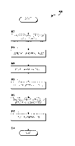
[00691 FIGURE 9 shows a routine 900 for determining landing sites for an
aircraft,
according to an exemplary embodiment. In one embodiment, the routine 900 is
performed by the routing module 102 described above with reference to FIGURE
1. It
should be understood that this embodiment is exemplary, and that the routine
900 may
be performed by another module or component of an avionics system of the
aircraft; by
an off-board system, module, and/or component; and/or by combinations of
onboard
and off-board modules, systems, and components. The routine 900 begins at
.. operation 902, wherein flight data is received. The flight data can include
flight plans
indicating a path for a planned flight. The flight path can be analyzed by the
routing
module 102 to identify landing sites such as airports, and alternative landing
sites such
as fields, golf courses, roadways, and the like. The routing module 102 can
access one
or more of the databases 104 to search for, recognize, and identify possible
alternative
landing sites for the anticipated flight path.
[00701 The routine 900 proceeds from operation 902 to operation 904, wherein
spanning
trees can be generated for each identified landing site and/or alternative
landing site.
As explained above, the spanning trees can be generated form the landing
sites, back
into the airspace along which the flight path travels. In some embodiments, a
spanning
tree is generated for each landing site along the flight path or within a
specified range of
the flight path. The specified range may be determined based upon intended
cruising
altitude and/or speed, and therefore the anticipated glide profile that the
aircraft may
have in the event of an emergency condition. It should be understood that this
embodiment is exemplary, and that other factors may be used to determine the
landing
sites for which spanning trees should be generated.
100711 The routine 900 proceeds from operation 904 to operation 906, wherein
the
generated spanning trees are loaded into a data storage location. The data
storage
17
CA 02796923 2012-10-19
WO 2011/152917 PCT/US2011/028795
location can be onboard the aircraft, or at the ATC, ARTCC, AOC, or another
location.
At some point in time, the aircraft begins the flight. The routine 900
proceeds from
operation 906 to operation 908, wherein in response to an emergency condition,
the
spanning databases are retrieved from the data storage device. The routine 900
proceeds from operation 908 to operation 910, wherein the spanning trees are
analyzed
to identify one or more attainable landing sites, and to prompt retrieval of
landing site
information such as distance from a current position, weather at the landing
sites, a time
in which the route to the landing site may be selected, and the like. The
routine 900
proceeds form operation 910 to operation 912, wherein the information
indicating the
landing sites and information relating to the landing sites such as distance
from a
current location, weather at the landing sites, a time in which the route to
the landing
site must be selected, and the like, are displayed for aircraft personnel. In
addition to
displaying a moving map display with the attainable landing sites and
information
relating to those landing sites, the routing tool 100 can obtain additional
real-time data
such as, for example, weather data between the current position and the
landing sites,
traffic data at or near the landing sites, and the like, and can display these
data to the
aircraft personnel.
[00721 The routine 900 proceeds from operation 910 to operation 912, wherein a
landing
site is selected, and the aircraft begins flying to the selected landing site.
In selecting
the landing site, the weather conditions at the landing site, near the landing
site, or on a
path to the landing site may be considered as visibility can be a vital
component of a
successful and safe ingress to a landing site. The routine 900 proceeds to
operation
914, whereat the routine 900 ends.
100731 Referring now to FIGURES 10A-10B, screen displays 1000A, 10008 provided
by
a graphical user interface (GUI) for the routing tool 100 are illustrated,
according to
exemplary embodiments. The screen displays 1000A-B can be displayed on the
pilot's
primary flight display (PFD), if the aircraft is so equipped, or upon other
displays and/or
display devices, if desired. FIGURE 10A illustrates a three-dimensional screen
display
1000A provided by the routing tool 100, according to an exemplary embodiment.
The
line 1002 represents a flight path required to safely ingress into the landing
site, and to
touchdown at the touchdown point 1004. The view of FIGURE 10A is shown from
the
perspective of the cockpit. From the illustrated perspective, it is evident
that the aircraft
currently is above the minimum altitude required for a safe landing, as
indicated by the
18
CA 02796923 2012-10-19
WO 2011/152917 PCT/US2011/028795
line 1002. Therefore, the aircraft has sufficient energy to reach the
touchdown point
1004.
100741 FIGURE 108 illustrates another three-dimensional screen display 1000E3
provided by the routing tool 100, according to another exemplary embodiment.
In
particular, FIGURE 108 illustrates a flight path 1010 for ingress to a landing
site. The
flight path includes targets 1012. During an approach, the pilot attempts to
pass the
aircraft through the targets 1012. Upon passing through all of the targets
1012, the
aircraft is in position to land at the landing site. Thus, the GUI provided by
the routing
tool 100 can be configured to provide guidance for a pilot to navigate an
aircraft to a
landing site in an emergency. These embodiments are exemplary, and should not
be
construed as being limiting in any way.
100751 According to various embodiments, the routing tool 100 interfaces with
an ATC,
ARTCC, or AOC to exchange information on potential landing sites as the flight
progresses, or for allowing the ATC or AOC to monitor or control an aircraft
in distress,
or to potentially reroute other aircraft in the area to enhance ingress
safety. According
to other embodiments, the routing tool 100 is configured to report aircraft
status
according to a predetermined schedule or upon occurrence of trigger events
such as,
for example, sudden changes in altitude, disengaging an autopilot
functionality, arriving
within 100 miles or another distance of an intended landing site, or other
events.
According to yet other embodiments, the routing tool 100 determines, in real-
time,
potential landing sites with the assistance of an off-board computer system
such as, for
example, a system associated with an ATC, ARTCC, or AOC. The routing module
can
transmit or receive the information over the current flight operations
bulletin (FOB)
messaging system, or another system.
100761 The ATC, ARTCC, and/or AOC have the capability to uplink information on
potential emergency landing sites as the aircraft progresses on its flight
path. For
example, the ATC, ARTCC, and/or AOC can use data in the databases 104 and data
from the real-time data sources 122 to determine a landing site for the
aircraft.
Information relating to the landing sites may be uplinked by any number of
uplink means
to the aircraft. The ATC, ARTCC, and/or AOC broadcast the information at
regular
intervals, when an emergency is reported, and/or when a request from
authorized
aircraft personnel is originated.
19
CA 02796923 2012-10-19
WO 2011/152917 PCT/US2011/028795
100771 In another embodiment the aircraft broadcasts potential landing sites
to the ATC,
ARTCC, or AOC as the aircraft progresses on its flight. Alternatively, the
aircraft
broadcasts only when there is an emergency or when a request for information
is made
from the ATC, ARTCC, or AOC. Thus, the ATC. ARTCC, or AOC can identify, in
real-
time or near-real-time, the chosen landing site of an aircraft posting an
emergency. If
appropriate, other traffic may be re-routed to ensure a safe ingress to the
chosen
landing site. It should be understood that the aircraft and the ATC, ARTCC, or
AOC can
have continuous, autonomous, and instantaneous information on the choices of
landing
sites, thereby adding an extra layer of safety to the routing tool 100.
100781 FIGURE 11 shows an illustrative computer architecture 1100 of a routing
tool 100
capable of executing the software components described herein for determining
landing
sites for aircraft, as presented herein. As explained above, the routing tool
100 may be
embodied in a single computing device or in a combination of one or more
processing
units, storage units, and/or other computing devices implemented in the
avionics
systems of the aircraft and/or a computing system of an ATC, AOC, or other off-
board
computing system. The computer architecture 1100 includes one or more central
processing units 1102 ("CPUs"), a system memory 1108, including a random
access
memory 1114 ("RAM") and a read-only memory 1116 ("ROM"), and a system bus 1104
that couples the memory to the CPUs 1102.
100791 The CPUs 1102 may be standard programmable processors that perform
arithmetic and logical operations necessary for the operation of the computer
architecture 1100. The CPUs 1102 may perform the necessary operations by
transitioning from one discrete, physical state to the next through the
manipulation of
switching elements that differentiate between and change these states.
Switching
elements may generally include electronic circuits that maintain one of two
binary
states, such as flip-flops, and electronic circuits that provide an output
state based on
the logical combination of the states of one or more other switching elements,
such as
logic gates. These basic switching elements may be combined to create more
complex
logic circuits, including registers, adders-subtractors, arithmetic logic
units, floating-point
units, and the like.
100801 The computer architecture 1100 also includes a mass storage device
1110. The
mass storage device 1110 may be connected to the CPUs 1102 through a mass
storage controller (not shown) further connected to the bus 1104. The mass
storage
CA 02796923 2012-10-19
WO 2011/152917 PCT/US2011/028795
device 1110 and its associated computer-readable media provide non-volatile
storage
for the computer architecture 1100. The mass storage device 1110 may store
various
avionics systems and control systems, as well as specific application modules
or other
program modules, such as the routing module 102 and the databases 104
described
above with reference to FIGURE 1. The mass storage device 1110 also may store
data
collected or utilized by the various systems and modules.
100811 The computer architecture 1100 may store programs and data on the mass
storage device 1110 by transforming the physical state of the mass storage
device to
reflect the information being stored. The specific transformation of physical
state may
depend on various factors, in different implementations of this disclosure.
Examples of
such factors may include, but are not limited to, the technology used to
implement the
mass storage device 1110, whether the mass storage device is characterized as
primary or secondary storage, and the like.
For example, the computer
architecture 1100 may store information to the mass storage device 1110 by
issuing
instructions through the storage controller to alter the magnetic
characteristics of a
particular location within a magnetic disk drive device, the reflective or
refractive
characteristics of a particular location in an optical storage device, or the
electrical
characteristics of a particular capacitor, transistor, or other discrete
component in a
solid-state storage device. Other transformations of physical media are
possible without
departing from the scope and spirit of the present description, with the
foregoing
.. examples provided only to facilitate this description. The computer
architecture 1100
may further read information from the mass storage device 1110 by detecting
the
physical states or characteristics of one or more particular locations within
the mass
storage device.
100821 Although the description of computer-readable media contained herein
refers to
a mass storage device, such as a hard disk or CD-ROM drive, it should be
appreciated
by those skilled in the art that computer-readable media can be any available
computer
storage media that can be accessed by the computer architecture 1100. By way
of
example, and not limitation, computer-readable media may include volatile and
non-
volatile, removable and non-removable media implemented in any method or
technology for storage of information such as computer-readable instructions,
data
structures, program modules, or other data. For example, computer-readable
media
includes, but is not limited to, RAM, ROM, EPROM, EEPROM, flash memory or
other
21
CA 02796923 2012-10-19
WO 2011/152917 PCT/US2011/028795
solid state memory technology, CD-ROM, digital versatile disks ("DVD"), HD-
DVD, BLU-
RAY, or other optical storage, magnetic cassettes, magnetic tape, magnetic
disk
storage or other magnetic storage devices, or any other medium which can be
used to
store the desired information and which can be accessed by the computer
architecture 1100.
.. 100831 According to various embodiments, the computer architecture 1100 may
operate
in a networked environment using logical connections to other avionics in the
aircraft
and/or to systems off-board the aircraft, which may be accessed through a
network
1120. The computer architecture 1100 may connect to the network 1120 through a
network interface unit 1106 connected to the bus 1104. It should be
appreciated that
.. the network interface unit 1106 may also be utilized to connect to other
types of
networks and remote computer systems. The computer architecture 1100 also may
include an input-output controller 1122 for receiving input and providing
output to aircraft
terminals and displays, such as the in-flight display 136 described above with
reference
to FIGURE 1. The input-output controller 1122 may receive input from other
devices as
well, including a PFD, an EFB, a NAV, an HUD, MDU, a DSP, a keyboard, mouse,
electronic stylus, or touch screen associated with the in-flight display 136.
Similarly, the
input-output controller 1122 may provide output to other displays, a printer,
or other type
of output device.
100841 Based on the foregoing, it should be appreciated that technologies for
determining landing sites for aircraft are provided herein. Although the
subject matter
presented herein has been described in language specific to computer
structural
features, methodological acts, and computer-readable media, it is to be
understood that
the invention defined in the appended claims is not necessarily limited to the
specific
features, acts, or media described herein. Rather, the specific features,
acts, and
mediums are disclosed as example forms of implementing the claims.
[00851 The subject matter described above is provided by way of illustration
only and
should not be construed as limiting. Various modifications and changes may be
made
to the subject matter described herein without following the example
embodiments and
applications illustrated and described, and without departing from the true
spirit and
.. scope of the present invention, which is set forth in the following claims.
22