Note : Les descriptions sont présentées dans la langue officielle dans laquelle elles ont été soumises.
CA 02804179 2012-12-31
WO 2012/004750
PCT/IB2011/052990
INDOOR SATELLITE NAVIGATION SYSTEM
BACKGROUND
I. Technical Field
Embodiments of the present invention relate generally to global navigation
satellite
systems (GNSS) and, more particularly, but not exclusively, to a system and
method that extends
navigation capability to enclosed areas that are substantially blocked from
receiving satellite
signals, such as the indoor area of buildings.
2. Description of Related Art
A global navigation satellite system (GNSS) consists of a network or
constellation of
satellites in orbit around the Earth, in which the satellites transmit signals
that are used by
terrestrial receivers for purposes such as navigation. The most established
and widely used
GNSS system at this time is the GPS system operated by the United States of
America. Other
GNSS systems include the GLONASS system operated by Russia, and the
forthcoming
European Galileo and Chinese Compass navigation systems. The present invention
is described
herein in teims of the GPS system, but it will be clear to those skilled in
the art that the principles
of the present invention may be used in the context of other GNSS systems.
The GPS system includes between 24 and 32 satellites in medium Earth orbit.
Each
satellite continuously transmits a navigation message that is modulated by its
own unique
PseudoRandom binary Code (PRN) that is orthogonal to all the other PRN codes
from the other
satellites. The GPS ranging code that is available for public use is the
"Clear Acquisition" (C/A)
code, which is a PRN code of 1,023 bits. The navigation message includes such
information as
its time of transmission, an ephemeris (plural: ephemerides), which precisely
describes the
satellite's orbit, and an almanac, which contains coarse orbit and status
information for all the
satellites in the network. The ephemeris is updated every two hours and is
generally valid for
four hours.
At the receiving end, the GPS receiver generates its own copies of the C/A
codes,
nominally synchronized with the satellite transmissions. When the receiver
receives the C/A
codes of the currently visible satellites (typically 8-12 satellites in open
terrain), the receiver
cross-correlates its copies of the C/A code with the received C/A codes to
identify the satellites
whose transmissions have been received. The ranges to the satellites may be
determined by
subtracting the time of transmission from the time received (to get transit
time), and dividing by
- 1 -
CA 02804179 2012-12-31
WO 2012/004750 PCT/IB2011/052990
the speed of light. Knowing the ephemerides, the receiver can compute the
locations of the
satellites at the times of the transmissions.
If the receiver's clock were perfectly synchronized with the satellites, then
signals from
three satellites would suffice to triangulate the position (horizontal
coordinates x and y, and
elevation z) of the receiver. Because clocks that could be synchronized that
well with the atomic
clocks used by the satellites are far too expensive for routine use, signals
from four or more
satellites are used to determine x, y, z and the time offset dt of the
receiver's clock from the GPS
clocks. If only the horizontal coordinates are needed for navigation then
signals from three
satellites suffice.
Figures lA and 1B illustrate the above process by which conventional GNSS
receivers
obtain position information from GNSS satellite signals. In FIG. lA four
satellites, Sat-1 to Sat
4, transmit navigation messages at times ti to t4. The four signals are
received by a GNSS
receiver, shown being held by a user. The receiver identifies the four
satellites from each
satellite's unique C/A code. The range "p" (greek: "row") to each satellite is
determined, as
noted above, by subtracting transmitted time (ti to t4) from the received time
and dividing by the
speed of light "C". From the ephemeris, the coordinate position of each
satellite at the time of
transmission may be determined, i.e. position of Sat-1 (xi, yi, zi), Sat-2
(x2, y2, z2), etc. Figure
1B shows how the range and position values may be plugged into the four
equations to determine
the coordinate position (X, Y, Z) of the GNSS receiver, and the time offset
"dT" of the receiver
relative to the satellite clocks.
An aspect of GNSS based navigation is that navigation generally cannot be
performed
indoors, since building walls and roofs act as barriers that block or diminish
the satellite signals.
Similar problems occur in some outdoor areas such as natural canyons, urban
areas lined with
tall buildings ("urban canyons"), and deep mountain valleys. In these
environments the satellite
transmissions are either unavailable or have power levels that are very low,
such as below the
background noise power level, so as to be unusable by a standard, unmodified
GPS receiver.
This is a problem since an estimated 80% of daily activity occurs in indoor
environments,
such as homes, offices, shopping areas, and elevators. Further, continuity of
service is disrupted
when, for example, a person walks from the street into a shopping mall or
building, or drives into
an underground parking lot or through a tunnel.
A number of attempts have been made to resolve this problem. In one approach,
networks
of physical sensors, such as infrared, ultrasound, or pressure sensors, are
distributed throughout a
building or enclosed area. A problem with physical sensors however is the need
for a wide
deployment of infrastructure.
- 2 -
CA 02804179 2012-12-31
WO 2012/004750 PCT/IB2011/052990
Another approach makes use of a different type of sensor that allows
positioning at the
user end using autonomous means. These include odometer, accelerometer,
gyroscope, and
magnetometer type sensors. The principle of this approach is to use GNSS
signals when
available, and to switch to the other sensor when GNSS signals are not
available. This approach
however requires very accurate modeling of the user's movements to be
effective.
Other approaches use modern telecommunication technology rather than physical
sensors. For example, one method uses mobile telecommunication networks such
as GSM and
UMTS, implemented by techniques such as TDOA, E-TDOA, and "Angle of Arrival".
This
approach is considered impractical due to the requirement that for
positioning, a minimum of
three base stations have to be seen from the mobile terminal. The approach
also suffers from
positioning inaccuracy caused from signal multipath.
Another telecommunication approach makes use of free or publicly available
infrastructure used for other purposes, such as mobile Internet access or
WiFi. In this case,
GNSS calculations are based on time measurements. However, time information
supplied by
non-GNSS sources is generally not accurate, causing a rough and jumpy effect
on the resulting
navigation outputs. For accurate implementation the time reference needs to be
seriously
upgraded as compared to current WLAN time capabilities.
Yet another location calculation technique is based on the Received Signal
Strength
Information (RSSI). This however requires the system to increase the number of
Access Points
to a level that is much greater than the number required for telecommunication
purposes. These
techniques also suffer from positioning inaccuracy caused from signal
multipath.
Some approaches to the indoor navigation problem are GNSS-based. For example,
one
technique uses "pseudo satellites" or "pseudolites", which creates a local
terrestrial constellation
of a few satellites (generators for instance). A problem with this approach
however is in
.. achieving synchronization between pseudolites. Additionally, this technique
suffers from
positioning inaccuracy caused from signal multipath.
Another GNSS-based technique involves placing GNSS repeaters in the indoor
area. The
repeaters however merely transmit information of an outside location. As a
result, this technique
does not really provide indoor navigation information.
Accordingly, current indoor coverage technologies generally provide only
limited and
inaccurate navigation in building indoors and other confined or blocked
spaces. Further, many of
these technologies require some type of modification of the GNSS receiver to
enable it to
recognize and use aided or augmented information. This is inconvenient,
increases the cost of the
receiver, and is useful only in areas that happen to have the particular
technology installed.
- 3 -
CA 02804179 2012-12-31
WO 2012/004750 PCT/IB2011/052990
BRIEF SUMMARY
According to an aspect of the present invention, there is provided a
navigation system for
an enclosed area, the navigation system comprising:
a) at least one satellite signal receiving station, positioned outside the
enclosed area, to
receive satellite signals transmitted by a constellation of satellites and to
determine time
synchronization information relative to the transmitted signals;
h) at least one local transmitting station, positioned within the enclosed
area, to transmit a
local signal compatible with the transmitted satellite signals; and
c) a communication channel to communicate self-alignment information between
each
Station and at least one other station;
wherein each local transmitting station uses the self-alignment information to
generate
the local signal;
and wherein the at least one local signal provides navigation infoiniation
useable by a
satellite navigation receiver.
The navigation system wherein the satellite signal receiving station further
includes a
transmitter to transmit a local signal compatible with the transmitted
satellite signals.
The navigation system wherein the self-alignment information includes
information
about local signal power levels.
The navigation system wherein the local signal comprises a simulation of at
least three
transmitted satellite signals.
The navigation system wherein the local signal comprises a simulation of four
transmitted satellite signals.
The navigation system wherein the self-alignment information further
communicates an
identity of the multiple transmitted satellite signals.
The navigation system further comprising a plurality of said local
transmitting stations,
and wherein each station is operative to select channels different than the
channels transmitted by
adjacent stations.
The navigation system wherein each pair of adjacent stations are positioned
apart by a
respective separation distance, and wherein the transmission range of the
local signals is greater
than half the separation distance and less than the separation distance.
The navigation system wherein the local signal transmission range is
approximately 0.7
of the separation distance.
- 4 -
CA 02804179 2012-12-31
WO 2012/004750 PCT/IB2011/052990
The navigation system wherein the system comprises two satellite signal
receiving
stations positioned outside the enclosed area, and wherein the self-alignment
information
includes time synchronization information from two stations to each local
transmitting station;
wherein the local signal transmitted by each local transmitting station
provides
substantially accurate positioning information for a two dimensional area.
The navigation system wherein the system comprises three satellite signal
receiving
stations positioned outside the enclosed area, and wherein the self-alignment
infoimation
includes time synchronization information from three stations to each local
transmitting station;
wherein the local signal transmitted by each local transmitting station
provides
substantially accurate positioning information for a three dimensional space.
The navigation system wherein each at least one satellite signal receiving
station
comprises a receiving antenna to receive satellite navigation signals, a
transmitting antenna to
transmit the local signal, and a processor to perform self-alignment
algorithms.
The navigation system wherein the communication channel is wireless.
The navigation system wherein the communication channel comprises unused
satellite
navigation channels.
The navigation system wherein the communication channel comprises a wired
connection
between adjacent stations.
According to an aspect of the present invention, there is provided a method of
providing
satellite signal information in an enclosed area, the method comprising:
a) deploying a plurality of local transmitters in the enclosed area; and
b) transmitting local signals compatible with transmitted satellite signals;
wherein the local signals provide navigation information useable by a
satellite navigation
receiver.
The method of providing satellite signal information further including
exchanging self-
alignment information with the local transmitters.
The method of providing satellite signal information wherein the local signals
provide
information from a plurality of satellites.
These, additional, and/or other aspects and/or advantages of the present
invention are: set
forth in the detailed description which follows; possibly inferable from the
detailed description;
and/or learnable by practice of the present invention.
- 5 -
CA 02804179 2012-12-31
WO 2012/004750 PCT/IB2011/052990
BRIEF DESCRIPTION OF THE DRAWINGS
The present invention will be further understood and appreciated from the
following
detailed description taken in conjunction with the drawings in which:
Figure lA is a graphical representation of a satellite navigation system of
the prior art
showing four satellites and a user holding a GNSS receiver;
Figure 1B is an illustration of mathematical equations used in a satellite
navigation
system of the prior art;
Figure 2A is a block diagram of an indoor satellite navigation system
consistent with an
embodiment of the present invention, showing the system in use in an enclosed
area and having a
live connection with satellites overhead;
Figure 2B is a block diagram of an indoor satellite navigation system
consistent with an
embodiment of the present invention, showing the system in use in an enclosed
area that is stand-
alone;
Figure 3 is an illustration of an indoor satellite navigation system
consistent with an
.. embodiment of the present invention, showing the system in use in a tunnel;
Figure 4 is an illustration of an indoor satellite navigation system
consistent with an
embodiment of the present invention, showing the system in use in a single
story indoor
environment;
Figure 5 is an illustration of an indoor satellite navigation system
consistent with an
embodiment of the present invention, showing the system in use in a multi-
story indoor
environment;
Figure 6 is a block diagram of a portion of an indoor satellite navigation
system
consistent with an embodiment of the present invention, showing three micro
simulators and
certain relationships between them;
Figure 7A is a flow chart of one type of self-alignment algorithms performed
by the
micro simulators, consistent with an embodiment of the present invention;
Figure 7B is a flow chart of another type of self-alignment algorithms
performed by the
micro simulators, consistent with an embodiment of the present invention;
Figure 8 is a block diagram of micro simulator "Q" of FIG. 6, illustrating how
the
invention is used to provide GNSS signals to a nearby receiver;
Figure 9A is a block diagram showing calculation of timing offset dT between a
micro
simulator and a single reference micro simulator, consistent with an
embodiment of the present
invention;
- 6 -
CA 02804179 2012-12-31
WO 2012/004750 PCT/IB2011/052990
Figure 9B is a block diagram showing calculation of timing offset dT between a
micro
simulator and two reference micro simulators, consistent with an embodiment of
the present
invention;
Figure 9C is a block diagram showing calculation of timing offset dT between a
micro
simulator and three reference micro simulators, consistent with an embodiment
of the present
invention;
Figure 10A is a block diagram of an exterior or outdoor micro simulator for
use in an
indoor satellite navigation system consistent with an embodiment of the
present invention; and
Figure 10B is a block diagram of an interior or indoor micro simulator for use
in an
indoor satellite navigation system consistent with an embodiment of the
present invention.
DETAILED DESCRIPTION
Reference will now be made in detail to embodiment(s) of the present
invention,
examples of which are illustrated in the accompanying drawings, wherein like
reference
numerals refer to the like elements throughout. The embodiment(s) is/are
described below to
explain the present invention by referring to the figures.
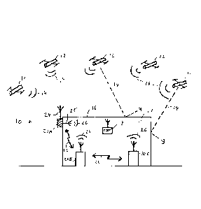
Referring now to FIG. 2A, there is shown a block diagram of an indoor
satellite
navigation system 10 consistent with an embodiment of the present invention.
The figure shows
five satellites 12 that are part of a global navigation satellite system
(GNSS). The satellites 12 are
in space orbit, and transmit GNSS signals 14 towards the ground. As shown,
there is located on
the ground a building or location 16 which contains an enclosed area 17. The
satellite GNSS
signals 14 are unable to enter enclosed area 17 due to the barrier of the
building roof and walls.
Accordingly, a GNSS or GPS receiver 18 located inside the building, in
enclosed area 17, is
unable to obtain the information needed to operate and to provide position
information.
For further clarity, the term "enclosed area" or "enclosed area 17" refers to
any
completely or partially enclosed space, area, or environment from which GNSS
signals are
completely, substantially, or partially blocked from entering, so that GNSS
signal strength is too
low for use or completely unavailable. A wide variety of enclosed areas are
comprehended,
including for example inner building floors and locations, shopping malls,
underground parking
lots and garages, elevators, hidden mountain roads, streets of urban canyons
where high rises
block GNSS signal reception, tunnelled roads, vessels, and airplanes.
Similarly, the teim
"outdoor area" refers to space, areas, or environments that are not enclosed
areas, i.e. where
typical GNSS signals are received by GNSS receivers and which retain
sufficient power so that
they can be processed to determine positioning results.
- 7 -
CA 02804179 2012-12-31
WO 2012/004750 PCT/IB2011/052990
According to some embodiments, system 10 of the present invention includes at
least two
stations or "micro simulators" (MS) 20 which are installed at the site of
building 16 and enclosed
area 17. A micro simulator is a device that has a multichannel GNSS
transmitter, a GNSS
receiver, and additional processing and communication components that enable
it to transmit and
imitate GNSS satellite signals, and to exchange information with other micro
simulators.
Micro simulators may be characterized by whether their transmitter (Tx) and
receiver
(Rx) operate inside enclosed area 17, i.e "In" or indoor, or outside enclosed
area 17, i.e "Out" or
outdoor. An "outdoor micro simulator" is one for which either the Tx or Rx
operate outdoors,
and the other antenna component operates indoors. An "indoor micro simulator"
is one for which
both the Tx and Rx operate indoors. Accordingly, there are three types of MS:
an "Rx-Out-Tx-
In" outdoor MS, an "Rx-In-Tx-Out" outdoor MS, and an indoor MS, which is
always "Rx-In-Tx-
In".
An outdoor MS of the type "Rx-Out-Tx-In" has a receiver that is located
outdoor and that
can receive GNSS satellite signals 14 directly from satellites 12, similar to
a GNSS receiver. The
outdoor MS of the type "Rx-In-Tx-Out" has a transmitter that is capable of
providing outside
coverage. This type of MS may optionally be used to provide additional
coverage in certain
situations. In many applications there will be relatively large numbers of
indoor micro
simulators, as this type of MS is used to span and provide continuous
navigation coverage within
enclosed area 17.
Turning to FIG. 2A, it may be seen that in this example system 10 has three
micro
simulators: outdoor MS 20A, and indoor micro simulators 20B and 20C. Outdoor
MS 20A has a
receiver 24 that is outdoors and that can receive satellite signals 14, and a
transmitter 25 which
transmits indoors, i.e in enclosed area 17. Indoor micro simulators 20B and
20C both receive and
transmit within enclosed area 17. For greater clarity, in the figures outdoor
micro simulators are
shown shaded and indoor micro simulators are shown unshaded.
System 10 also includes a means of communication between micro simulators to
enable
transmission and exchange of certain information. This is represented in FIG.
2A by line 22. As
will be discussed in greater detail below, communication line 22 may be
implemented by a
variety of embodiments, including for example wired or wireless techniques,
and accordingly
.. may or may not involve actual additional physical hardware.
At least one MS acts as a synchronization master MS (or just "master MS"),
which an
MS that knows its position. A master MS may be an outdoor MS that has a
receiving antenna Rx
that can receive GNSS signals 14 from satellites, and from that determine its
position. An indoor
MS can also be a master MS, even though it can't receive a GNSS signal from a
satellite, as long
- 8 -
CA 02804179 2012-12-31
WO 2012/004750 PCT/IB2011/052990
as it is provided with its position by a system administrator. For example, a
survey may be
performed to deteunine its position, and this value entered into the processor
of the indoor MS.
Information flows sequentially through each MS in system 10, beginning with a
master
MS. For example, in FIG. 2A information flows from outdoor MS 20A (assuming it
is a master
MS) to indoor MS 20B, and from indoor MS 2011 to indoor MS 20C. The embodiment
of FIG.
2A may be called a "live connection" type since it has an outdoor MS which
maintains a live
connection to active GNSS satellites and can actively obtain its position.
Each MS 20 in FIG. 2A transmits a local GNSS signal 26 which contains the
signals that
would be received from four or more (typically four) of the GNSS satellites at
a nominal
location, if those satellites were visible from that location. The local GNSS
signal 26 may be
described as a simulated satellite signal produced by MS 20. The nominal
location is typically
the MS location, but it may also be a different location that is related to or
offset from the MS
location. Accordingly, in FIG. 2A, GNSS receiver 18 may move about enclosed
area 17 and
obtain relevant location readings.
Another embodiment of system 10 is shown in FIG. 2B. In this embodiment the
enclosed
area is totally underground, for example a mine. Accordingly all of the MS's
are indoor micro
simulators. Since there are no outdoor MS's and no live connection to
satellites 12, this type of
system is called "stand alone". In this embodiment one or more of the MS's are
master MS's
who are supplied with their position. It may be noted that the position
supplied does not have to
be the true position. It could be arbitrary, and the system will work because
all of the other MS's
will be synchronized and in a consistent relationship to the master MS. The
stand alone system
shown will work with stored or historical satellite data that is provided to
the units.
In practice, GNSS systems are always in motion, since each satellite in view
delivers a
continuous stream of navigation messages while in motion, and individual
satellites are
constantly coming in and going out of view. As will be described in greater
detail below, system
10 of the present invention is able to adapt or self-align to these and other
changes, so that it is
able to maintain full and continuous navigation coverage in enclosed area 17.
These adaptations
include, for example, adjusting any or all of the timing, satellite selection,
and power of local
GNSS signals 26, and providing updated ephemerides of visible satellites.
Accordingly, it is to be appreciated that system 10, according to some
embodiments of
the present invention, adds practical navigation signals and supports full,
continuous navigation
coverage by GNSS receivers in environments where GNSS signals are absent or
for practical
purposes do not exist.
- 9 -
CA 02804179 2012-12-31
WO 2012/004750 PCT/IB2011/052990
Figures 3-5 are provided to illustrate example configurations or applications
of system
of the present invention.
Figure 3 shows a side view of a tunnel 28 having a roof 29 and a road surface
30 for
transport of pedestrians and vehicles such as automobiles 31. Satellite
navigation would
5 ordinarily not be possible in enclosed area 17 inside tunnel 28 due to
the blocking of satellite
signals 14 by roof 29. As shown, system 10 may include two outdoor micro
simulators 20,
positioned outside the tunnel at either end, and a group of indoor micro
simulators 20 inside the
tunnel. While three indoor micro simulators 20 are shown, it may be
appreciated that as many
indoor micro simulators 20 may be installed as necessary to provide continuous
coverage over
10 the length of the tunnel.
Two outdoor micro simulators 20 are used in this example, positioned at the
entrance and
exit at opposite ends of the tunnel. In configuring system 10 of the present
invention, either one
of the outdoor micro simulators would have an outdoor Rx (i.e. Out-Rx-In-Tx)
and the other one
could have an outdoor Tx (i.e In-Rx-Out-Tx). The Out-Rx MS would receive
satellite signals 14
from overhead satellites 12 and be the master MS. Communication would proceed
from that MS
through the indoor micro simulators, until termination at the Out-Tx outdoor
MS 20. While the
terminating outdoor MS is not used to receive satellite signals 14, its
outdoor location is still
useful to ensure that GNSS reception during travel into or out of the tunnel
is smooth and
uninterrupted.
In FIG. 3 the indoor micro simulators are shown attached to roof 29 of the
tunnel. Since
the users of the tunnel are pedestrians and drivers who will be closer to the
road surface 30, in
this situation it would be useful to configure local GNSS signal 26 so that it
provides a nominal
location on the road, below and offset from the actual roof location of MS 20.
Figure 4 shows a perspective view of a single story building 32, or of a floor
in a
.. building. In this configuration there are two outdoor micro simulators 20,
and a group of indoor
micro simulators 20 that span enclosed area 17. In this example both outdoor
micro simulators
20 may have an outside Rx and receive satellite signals 14.
In another example, FIG. 5 shows a side view of a multi-story building 33.
This setup
could represent an office or condominium tower, a shopping center, or parking
garage, among
others. As shown, system 10 could be configured with three outdoor micro
simulators 20 of Rx-
Out-Tx-In type on the roof. Each floor could have a group of indoor micro
simulators 20 that
span the interior, similar to that shown in the example of FIG. 4.
In general, it is useful to place micro simulators at each entrance and/or
exit of a building,
and next to specific stores in the case of a shopping mall, for example. If
there are obstacles such
- 10 -
CA 02804179 2012-12-31
WO 2012/004750 PCT/IB2011/052990
as pillars or posts then additional micro simulators may be needed to provide
continuous
coverage.
Figure 6 is a graphical representation of a portion of system 10 that may be
used to
illustrate some of the principles of operation of the invention. As indicated,
the figure shows
three micro simulators, which presumably are part of a much larger network of
micro simulators
from an installation of system 10. The three MS's are designated by the
letters "P", "Q", and
"R", or equivalently by MS 20P, MS 20Q, and MS 20R. MS 20Q is an indoor MS,
and MS 20P
and MS 20R may be either outdoor or indoor MS's. For the purposes of analysis,
MS 20P and
MS 20R are assumed to be indoor MS's.
The figure also shows information communication lines 22pq and 22qr, to
represent the
information flow or communication channel between adjacent MS's P and Q, and Q
and R,
respectively. Other communication lines 22 are shown that connect MS's P and R
to other MS's
not in the figure. The information flow or sequence is presumed to be from
left to right, i.e. from
an outside MS to MS 20P, then from MS 20P to MS 20Q, then from MS 20Q to MS
20R, and
then from MS 20R to an outside MS.
In order to view these three micro simulators, which form only a portion of
system 10, in
context, FIG. 6 also shows a constellation of twelve satellites overhead,
which are identified by
numbers 1 to 12. There is also shown a barrier 34 which represents any type of
signal block, such
as a roof of a building or a land mass forming the upper portion of a tunnel,
for example. As a
.. result, all of the area in FIG. 6 below barrier 34 is blocked enclosed area
17.
According to some embodiments of the invention, the three micro simulators
shown, P,
Q, and R, along with the other micro simulators in the system, are positioned
so that they are
separated from each other by a substantially equal distance, designated "5".
Accordingly, it is to
be appreciated that the number of micro simulators needed to adequately span a
given space may
be determined by dividing the length of the space by separation distance "5".
More particularly,
while the micro simulators may be placed at any separation distance that is
convenient, it is
advantageous to keep the separation distance fairly uniform, for reasons that
are discussed
further below. In FIG. 6, for ease of illustration, the communication lines
22pq and 22qr may
also be used to represent the separation distance between MS's. Accordingly,
line 22pq may be
said to represent a separation distance "S" between MS 20P and MS 20Q, and
line 22qr
similarly represents a separation distance "S" between MS 20Q and MS 20R.
Each MS is transmitting on its transmitter Tx its own local GNSS signal 26.
Each MS is
also receiving on its receiving antenna Rx the local GNSS signal 26 of its
neighboring MS that
precedes it in the information flow sequence. Specifically, MS 20P receives or
detects the local
-11 -
CA 02804179 2012-12-31
WO 2012/004750 PCT/IB2011/052990
GNSS signal from an MS to its "left" that is not shown in the figure, MS 20Q
receives local
GNSS signal 26 transmitted by MS 20P, and MS 20R receives local GNSS signal 26
transmitted
by MS 20Q. The use to which these received signals are put will be described
further below.
It may be noted that since the local GNSS signals 26 are transmitted at very
low power,
in order to detect these signals the micro simulators are configured to have,
according to some
embodiments of the invention, receivers Rx having a very high level of
sensitivity.
As noted, communication of synchronization information between micro
simulators, as
represented in the figures by line 22, may be implemented in a variety of
ways. According to
some embodiments, communication may be through a dedicated wired local area
network. This
may include, for example, optical fiber or copper wire based networks.
Another approach is to employ wireless communication techniques. This has the
advantage of using hardware that is already present, so that costs and
components may be kept to
a minimum. There are several ways that information may be transmitted on
unlicensed frequency
bands outside of the GNSS frequency bands, to keep the information signals
from interfering
with the navigation signals. One way is to use frequency division multiple
access, which is
analogous to the use of a WiFi wireless LAN. Another way is to use separate
directional
transmitting and receiving antennas on the micro simulators. A third, less
preferred way is to use
time division multiple access. In this technique, the transmission of the
simulated satellite signals
26 is occasionally paused to allow the exchange of information.
Another way of keeping the synchronization signals from interfering with the
navigation
signals takes advantage of the fact that the GPS system uses only 36 of the
1023 possible GPS
C/A codes. Since seven C/A codes are reserved for satellite-based augmentation
systems, there
remain 980 C/A codes available for use by system 10 for transmitting other
information. Because
the C/A codes are mutually orthogonal, the GPS receiver will ignore the C/A
codes that are used
for transmitting the synchronization signals.
The transmitters and receivers provided in the micro simulators may be adapted
for use
with whichever method is selected to communicate synchronization information.
According to some embodiments of the invention, in order to provide effective
and
continuous GNSS signal coverage for enclosed area 17, the micro simulators
need to maintain
certain conditions in the system relating to the power of transmission,
selection of satellites
transmitted, and synchronization or timing of the local GNSS signals.
Additionally, updated
ephemeris information for satellites in view by outdoor micro simulator needs
to be provided.
The particulars of these conditions and the procedures used to maintain them
will now be
discussed.
- 12 -
CA 02804179 2012-12-31
WO 2012/004750 PCT/IB2011/052990
Beginning with the power requirements, according to some embodiments of the
invention, where the separation distance between adjacent micro simulators is
"s", the effective
range of transmission of each micro simulator's local GNSS signal 26 should be
approximately
1.4 times the halfway point, or about 0.7 of the separation distance "s".
This aspect of system 10 of the present invention is shown in FIG. 6. The
halfway point
between micro simulators 20P and 20Q, and between 20Q and 20R, is shown as
"s/2". The
range of transmission "r" of each micro simulator is illustrated for each MS
by an arrow "r" and
a dashed circle 36. It can be seen that the range of transmission, as
represented by the circles 36,
extends past the halfway point s/2 of separation lines 22pQ and 22QR (note
that the figure is not
drawn to scale). Figure 6 also shows how adjacent circles 36 intersect, so
that an overlap area 37
is defined in the transmission range between adjacent micro simulators.
The effect of this signal power configuration may now be reviewed. When GNSS
receiver 18 is located within the transmission range r of a micro simulator
but not in an overlap
area, the predominant signal received will be local GNSS signal 26 from that
micro simulator.
For example, a receiver 18 located at point T1 in FIG. 6 will receive a strong
local GNSS signal
26 from MS 20P, since it is within the transmission range of MS 20P. The local
GNSS signal 26
from MS 20Q will be relatively very weak since point Ti is beyond the
transmission range of
MS 20Q. Similarly, at points T2 and T3 the receiver will predominantly receive
local GNSS
signals 26 from MS 20Q and MS 20R, respectively. Accordingly, at points Ti,
T2, and T3,
GNSS receiver 18 will compute and return locations corresponding to the
locations of MS 20P,
MS 20Q, and MS 20R, respectively (or nominal locations related to these
locations).
When GNSS receiver 18 is located in overlap area 37, such as at points T4 and
T5 in
FIG. 6, the receiver will receive two local GNSS signals 26. In that situation
the GNSS receiver
will compute its location as an average of the two, or at about the halfway
point s/2.
Accordingly, it may be appreciated that the resolution of system 10 of the
present invention is
about half the spacing between adjacent micro simulators, or about s/2. For
example, if the
separation distance "s" between micro simulators in a particular installation
is 50 meters, then
the position resolution will be 25 meters. It may also be appreciated that
this configuration
enables position values to transition relatively smoothly by steps of s/2
instead of steps of length
"s".
Another aspect of system 10 of the present invention is the selection of
satellites to be
transmitted as simulated GNSS signals by each MS. As noted, in the example
configuration of
FIG. 6 there are twelve satellites, Sat-1 to Sat-12, that are generally
visible or overhead, above
barrier 34, at a particular time. These satellites are known to the system
through direct reception
- 13 -
CA 02804179 2012-12-31
WO 2012/004750 PCT/IB2011/052990
of the satellite signal 14 by one or more associated outdoor micro simulators,
and/or from
information provided by the almanac, which is carried by all satellites.
According to some
embodiments of the invention, the almanac and ephemerides may also be received
by the system
through other means than by satellite signals, such as from the Internet or
from another external
source.
According to some embodiments of the present invention, system 10 is
preferably
configured so that each micro simulator transmits signals of a different set
of satellites than the
satellites transmitted by adjacent micro simulators. As shown in FIG. 6, local
GNSS signal 26 of
MS 21W transmits signals corresponding to satellites 2, 5, 7, and 12. MS 20Q
transmits signals
from satellites numbered 1, 4, 8, and 9, and MS 20R transmits signals from
satellites numbered
2, 6, 7, and 11. Accordingly, there are no satellite signals in common between
adjacent micro
simulators MS 20P and MS 20Q (i.e 2,5,7,12 and 1,4,8,9), and between MS 20Q
and MS 20R
(i.e 1,4,8,9 and 2,6,7,11). While satellites 2 and 7 are both used in MS 20P
and MS 20R, this is
acceptable because MS 20P and MS 20R are not adjacent.
An advantage of transmitting different sets of satellites from adjacent micro
simulators is
that it reduces the risk of error by the GNSS receiver. For example, suppose
that the satellites of
MS 20Q were 1,5,8,9 instead of 1,4,8,9, so that satellite 5 was now in common
with MS 21W. A
receiver at point T4 in overlap area 37, for example, would pick up satellite
5 from two local
GNSS signals, that of MS 21W and MS 20Q. Since each satellite 5 emanates from
a different
source, it may cause inaccuracies and possible multipath error at the
receiver. Errors may also
occur even outside of the overlap area, for example at T1 or T2, where the
receiver would
receive a strong satellite 5 and a weaker satellite 5 from a different path.
This risk may be
avoided through selection of distinct satellite selections by adjacent micro
simulators.
According to some embodiments of the invention, if adjacent micro simulators
were to
have a satellite in common, for any particular reason, the MS could be
configured to lower the
power of the channel carrying the satellite in common, thereby reducing the
risk of inaccuracy or
error described above.
In order to ensure appropriate satellite assignment, each micro simulator
communicates
its selected satellites to the adjacent micro simulator. For example, MS 21W
communicates to MS
20Q that MS 21W is using satellites 2,5,7, and 12. The self-alignment
algorithms of MS 20Q use
this information to select a distinct set of four satellites, such as 1,4,8,
and 9.
It may also be noted that in cases where only horizontal navigation is needed,
for
example inside a tunnel as shown in FIG. 3, then each micro simulator would
only need to
simulate the signals of three satellites instead of four satellites.
- 14 -
CA 02804179 2012-12-31
WO 2012/004750 PCT/IB2011/052990
In local GNSS signals 26, each satellite transmission includes a time of
transmission "t".
This time forms part of the information used by GNSS receiver 18 to compute
location, i.e. the
transmitting MS or nominal location offset from the transmitting MS. In order
to provide
accurate and smooth navigation, the micro simulators in system 10 need to be
synchronized with
one another. As noted, in the case where there is a live connection, the MS's
would also be
synchronized with the clock of satellites 12.
According to some embodiments of the invention, synchronization may be
achieved by
selecting outdoor MS 20 as the synchronization master. Outdoor MS 20 is an Out-
Rx-In-Tx type,
and so receives GNSS satellite signals 14 directly, and calculates its time
offset dT with the
satellite clock. Outdoor MS 20 transmits its own set of four or more simulated
satellite signals,
either by repeating the signals received from the satellites or by simulating
the signals in the
manner of indoor micro simulators 20. Outdoor MS 20 also uses the
communication channel 22
to relay its time offset from the GPS satellite clock to adjacent indoor MS
20.
Indoor MS 20 receives at its receiver Rx the simulated satellite signals from
outdoor MS
20, and uses the signal information to compute a location. The computed
location is only the
location of outdoor MS 20, but a by-product of the computation is the time
offset between the
clock of outdoor MS 20 and indoor MS 20.
The process continues sequentially, with every other indoor MS 20 receiving
the local
GNSS signals 26 from its adjacent indoor MS 20 (such as from the MS
immediately to its left. as
drawn in FIG. 1), and uses those signals to compute its time offset from the
adjacent indoor MS
20. Each indoor MS 20 then sends, on communication line 22, the cumulative
time offset, i.e the
total time offset from outdoor MS 20 up to that point, to the next adjacent MS
20 in sequence (i.e
the one to the "right"). In the example of FIG. 6, MS 20Q detects local GNSS
signal 26 from
MS 20P, and uses this information to determine its time offset to MS 20P. In
this manner, all
indoor MS's 20 eventually obtain their respective time offsets from master
outdoor MS 20 and
so become synchronized to the satellite GPS clock.
As noted, any micro simulator 20 could be used as the synchronization master,
to make
the timing of system 10 internally consistent. A GPS receiver 18 that is
inside enclosed area 17
navigates according to time as kept by system 10, not according to CPS
satellite time.
Nevertheless, it is preferable to synchronize system 10 to the GPS satellite
clock as described
above, by using outdoor MS 20 as the synchronization master, in order to
provide smooth
handoff of the CPS receiver 18 upon entering and exiting enclosed area 17.
Systems 10 that are
synchronized to a master MS that is not synchronized to the satellite clock
will likely cause UPS
receivers to lose location information, at least for a short time, upon
entering and exiting
- 15 -
CA 02804179 2012-12-31
WO 2012/004750 PCT/IB2011/052990
enclosed area 17. It may also be noted that in principle, indoor micro
simulators 20 could be
individually or collectively synchronized by cable connections to a common
clock that is in turn
is synchronized to the GPS satellite clock, though this is less preferable
than synchronizing from
outdoor MS 20 as described above.
In order for an indoor MS 20 to transmit the simulated satellite signals 26
associated with
the nominal location, the MS must know the ephemerides of the satellites whose
signals are
being simulated. These ephemerides values could be obtained from the Internet
or a
telecommunications connection. Alternatively the ephemerides may be obtained
from outdoor
MS 20, which can receive the ephemerides of all satellites in view through its
reception of GNSS
satellite transmission signals 14, and then transmit these values on
communication channel 22 to
the indoor MS's in the system. In this way, by periodically transmitting the
ephemerides, outdoor
MS 20 both updates the ephemerides used by indoor MS's 20 and ensures that the
indoor MS's
simulate only satellites that are currently visible.
The operation of the present invention, according to some embodiments, may now
be
reviewed. Master outdoor MS 20 begins by receiving GNSS satellite transmission
signals 14,
and uses that to acquire the time offset dT to the GPS satellite clock and the
ephemerides of
visible satellites. Optionally the almanac may be obtained, to assist the MS
in anticipating which
other satellites may be coming into view. The outdoor MS selects four
satellites and a power
level for transmitting indoors, and communicates to adjacent indoor MS 20 the
satellite time
offset dT, the ephemerides of all satellites 1-12, the satellites it selected,
and its power
transmission level.
According to some embodiments of the invention, there is a method of self-
alignment,
designated method "A" for convenience, that is described by the flow chart of
FIG. 7A. In this
method an external (wired or wireless) communication channel 22 is used to
synchronize time
between micro simulators. The local GNSS signal 26 measures the time delay
between the MS's
and can be used to measure MS location. This system needs as many
synchronization masters as
there are dimensions of the system (i.e one station per dimension) and each MS
should be
connected to as many adjacent MS's as there are dimensions of the system.
The flow chart of FIG. 7A illustrates self-alignment method A, according to
some
embodiments of the invention. After startup, in module 42 the MS detects local
GNSS signal 26
from the adjacent MS. From this, in module 44 the MS calculates its time
offset dT1 to the
adjacent MS. In module 46 indoor MS receives information from the adjacent MS
containing
cumulative timing dTri, system time, satellite selection, optionally the power
level, and
ephemerides of all satellites 1-12. The system time is simply the synchronized
time of the system
- 1 6 -
CA 02804179 2012-12-31
WO 2012/004750 PCT/IB2011/052990
provided by the master MS. In module 48 the indoor MS determines the time
offset relative to
the GPS satellite clock, dTnew dT1 dTn. In module 50 the MS selects four
satellites for local
transmission, where those satellites are different from those used by the
adjacent MS. In module
52 the MS determines the power level (dbm) and timing of transmission of local
GNSS signal
26. In module 53 the MS determines its position or location using the above
information.
In module 54 MS transmits local GNSS signal 26 for the selected satellites,
using dTnew
to obtain an appropriate time of transmission, and using the determined power
level. The signal
includes timing information and the ephemerides of the four selected
satellites.
More particularly, the MS calculates the parameters of local GNSS signal 26.
The MS calculates
what time "t" to apply to each channel, so that, using ephemerides, the GNSS
signal gives a
position that it wants the receiver to have. i.e. the location coordinates of
the MS, or a nominal
position related to the MS position.
In module 56 the indoor MS sends to the next MS in sequence information of
cumulative
timing offset dTnew, the system time, the satellites it selected, optionally
its power level, and the
ephemerides of all satellites. Control then returns to start module from
module 58, and the cycle
repeats. The same procedure is followed by all the other micro simulators in
system 10.
According to some embodiments of the invention, there is a type of self-
alignment called
method "B" for convenience. In this method communication channel 22 uses the
GPS C/A codes
as described above. The local GNSS signal 26 synchronizes the system time and
communication
channel 22 is used to measure time delay or distance between MS stations. Like
method "A", in
this case the system needs as many master MS's as there are dimensions of the
system, i.e one
station per dimension, and each MS should be connected to as many adjacent
MS's as there are
dimensions of the system.
Turning to the flow chart of FIG. 78, at module 60 the MS detects local GNSS
signal 26
from adjacent MS. At module 62 the MS calculates the system time from the
adjacent MS. At
module 64 the MS receives from adjacent MS on the communication channel: the
satellite
selection of adjacent MS, optionally the power level of adjacent MS, and the
ephemerides of all
the satellites in view. At module 66 MS calculates the delta time from
adjacent MS. At module
68 MS selects satellites for transmission. At module 70 MS determines the
power level and
timing for local GNSS signal 26. At module 72 MS determines its position. At
module 74 the
MS transmits local GNSS signal 26 for the selected satellites. At module 76
the MS sends to the
next MS on the communication channel: its satellite selection, optionally the
power level, and the
ephemerides of all the satellites in view. At module 58 it returns to start
and repeats.
- 17 -
CA 02804179 2012-12-31
WO 2012/004750
PCT/IB2011/052990
Another aspect of the power alignment of the system 10 of the present
invention is that if
the power of transmission of a particular MS is too large, the adjacent MS may
detect this and
communicate a message to reduce power. For example, in FIG. 6, if the
transmission power of
MS 20Q becomes too large, as represented by circle 36Q getting larger and
getting too close to
MS 20P and MS 20R, then MS 20P and/or MS 20R may communicate with MS 20Q, on
channel 22, to reduce transmission power. According to some embodiments of the
invention, the
detection of power may be done by the reception of the local GNSS signal 26.
According to
other embodiments of the invention, the detection of power may be done through
the power level
being communicated on communication channel 22.
It may be appreciated that in this way, the self-alignment algorithms
calculate, control,
and generate the power levels and timing of the transmitted local GNSS signals
26, and select the
satellites to be transmitted. Accordingly, each micro simulator is dynamically
controlled by these
algorithms.
Figure 8 illustrates the effect of system 10 of the present invention, with
respect to
representative micro simulator MS 20Q of FIG. 6. As indicated, the effect is
as if barrier 34 has
been removed and is no longer there, so that selected satellites 1, 4, 8, and
9 are free to transmit
and have their signals 14 received at MS 20Q. These signals, which contain C/A
codes and time
of transmission "t" for each channel, and their ephemerides, are re-
transmitted or simulated at a
lower power level, shown by dashed arrow 38, so that GNSS receiver 18 within
range of
transmission of local signal 26 of MS 20Q receives the signal as if it were
located at position Q
("posQ"). The local signal 26 is accordingly compatible with transmitted
satellite signals 14.
In FIG. 2A the layout of MS's is linear, or one-dimensional. In cases of two-
dimensional
or three-dimensional arrays of MS's, more master MS's are provided.
Specifically, at least two
master MS's are provided for two-dimensional arrays and at least three master
MS's for three-
dimensional arrays. In these cases the locations of MS's are obtained by
triangulation based on
round-trip signal travel times among the micro simulators. The process starts
with round-trip
signal travel times between the outdoor MSs and the adjacent indoor MS's, and
takes into
account the fixed and known delays within micro simulators in responding to
received
triangulation signals. By contrast, the locations of micro simulators of a
linear layout such as the
layout of FIG. 2A are obtained by conventional surveying methods.
Triangulation may be further explained using FIGS. 9A-C and the examples of
FIGS. 3-
5_ Figure 9A shows MS 20 obtaining time offset dT with respect to a single
adjacent reference
micro simulator. The distance from the reference micro simulator to MS 20 is
indicated by arrow
"w". It can be seen that MS 20 can move along an arc 39 having a radius "w".
However, at any
- 18 -
CA 02804179 2012-12-31
WO 2012/004750
PCT/IB2011/052990
position along the arc the distance from the reference MS is the same, so the
time offset dT will
be the same. The time offset will remain the same even as MS 20 moves in two-
dimensional
space. Accordingly, obtaining a time offset from one reference is not
sufficient to fix the location
of MS 20 in two-dimensional space.
This may be resolved by using two reference micro simulators, as shown in FIG.
913. The
distance from each reference is "w" and "v". In this case, as MS 20 moves in a
plane, at least one
of the reference distances will also change, Le. there will be a unique "v"
and "w" for each
position of MS 20 in two-dimensional space. Similarly, by the same principle,
in order to
determine the location of MS 20 in three dimensional space, three reference
micro simulators
should be used, as shown in FIG. 9C.
Turning now to the examples of FIGS. 3-5, it may be seen that in the tunnel
example of
FIG. 3, the only significant motion that occurs in the tunnel is progress
along the straight road
30. For this application therefore use of a single reference MS should be
sufficient. Outdoor MS
on the left could be the master, and adjacent indoor MS 20m1 could synchronize
with it, then
15 MS 20m2 would synchronize with MS 20m1, etc.
In the floor or room example of FIG. 4, movement will occur in two dimensions
but
likely not in three dimensions (i.e not up and down). It is accordingly
important to obtain
synchronization in two dimensions. The two outdoor micro simulators could be
masters, or one
outdoor and one indoor, to maintain a live connection. As an example,
synchronization may
20 proceed as follows: indoor MS 20k1 synchronizes from the two outdoor
MS's. Then indoor MS
20k2 synchronizes from one of the outdoor MS's and from indoor MS 20k1. Indoor
MS 20k3
then synchronizes from indoor MS's 20k1 and 20k2, etc.
The process is the same for the multi-story example of FIG. 5. Here movement
is in all
three dimensions, including up and down. Accordingly, three reference or
master micro
.. simulators are needed for synchronization. These may be, for example, the
three outdoor micro
simulators. Synchronization may proceed as follows: indoor MS 20d1
synchronizes from the
three outdoor micro simulators. Then indoor MS 20d2 synchronizes from two of
the outdoor
micro simulators and from indoor micro simulator 20d1. Then indoor MS 20d3
synchronizes
from one of the outdoor micro simulators and from indoor micro simulators 20d1
and 2012.
Then indoor MS 20d4 synchronizes from three indoor MS's 20411, 20d2, and 20d3.
Block diagrams of outdoor and indoor micro simulators, according to some
embodiments
of the invention, are shown in FIGS. 10A and 10B, respectively.
As indicated, outdoor MS has a single receiver Rx to receive the GNSS signals
from
GNSS satellites. This information is processed by a self alignment processing
and control
- 19-
CA 02804179 2012-12-31
WO 2012/004750
PCT/IB2011/052990
module and subsequently by an out-in control module, before being transmitted
as a local GNSS
signal from transmitter Tx.
Some of the advantages of system 10 of the present invention may now be
reviewed.
In a live connection, the system provides a live reading based on real
satellites overhead.
This provides a dynamically changing infrastructure that adapts itself and
attributes transmitted
GNSS signals to the enclosed area environment. Each micro simulator
automatically measures
its relative location with respect to its neighbour, which are other self
aligned micro simulators,
calibrates itself, and transmits the required signal accordingly.
Since the system transmits GNSS satellite signals that contain the same
information and
are on the same frequency as signals transmitted by satellites, regular GNSS
receivers may be
used. More particularly, no modifications need to be made to the hardware or
firmware of the
receivers. Similarly, there are no special "modes" in which the receiver needs
to operate, or
augmented information that the receiver has to be configured to use.
When synchronization occurs with the satellite's UPS clock, such as when an
outdoor
MS is used, system 10 enables users to enter or exit from enclosed areas 17
with no discontinuity
or disruption. Inside enclosed areas 17 system 10 full and continuous coverage
is provided,
whether synchronization is with the satellite's UPS clock or just between the
micro simulators of
the system.
Since each local GNSS signal 26 carries simulated signals of four satellites,
multipath is
not a problem because all four satellite signals travel the same path to the
receiver.
Full coverage can easily be provided in an enclosed area 17 by providing
sufficient
number of micro simulators to cover the area.
The invention enables continuous navigation in areas that were previously
unable to
receive satellite signals, or where the signals were too weak to be processed
by conventional
GNSS receivers. The invention disributes micro simulators that combine GNSS
receivers and
GNSS transmitters to best cover the enclosed area.
The GNSS-like signals generated by the infrastructure of this invention are
controlled and
processed by self alignment algorithms that synchronize them with signals from
actual satellites.
Although selected embodiment(s) of the present invention has/have been shown
and
described, it is to be understood that the present invention is not limited to
the described
embodiment(s). Instead, it is to be appreciated that changes may be made to
this/these
embodiment(s) without departing from the principles and spirit of the
invention, the scope of
which is defined by the claims and the equivalents thereof.
- 20 -