Note : Les descriptions sont présentées dans la langue officielle dans laquelle elles ont été soumises.
CA 02811492 2014-12-23
79700-86
MARINE SEISMIC SURVEY SYSTEMS AND METHODS USING
= AUTONOMOUSLY OR REMOTELY OPERATED 'VEHICLES
CROSS-REFERENCE TO RELATED APPLICATIONS
This application claims the benefit of U.S. Provisional Patent Application
Nos.
61/440,136, filed on February 7, 2011; 61/413,217, filed on November 12, 2010;
and
61/38.3,940, filed on September 17, 2010.
TECHNICAL FIELD
The present disclosure relates in general to marine seismic data acquisition,
and more
particularly to systems and methods for conducting seismic surveys and
performing activities
related to seismic surveys using autonomously operated vehicles (A0Vs) and/or
remotely
operated vehicles (ROVs).
BACKGROUND
Seismic exploration involves surveying subterranean geological formations for
hydrocarbon deposits. A seismic survey typically involves deploying seismic
source(s) and
seismic sensors at predetermined locations. The sources generate seismic
waves, which
propagate into the geological formations creating pressure changes and
vibrations along their
way. Changes in elastic properties of the geological formation scatter the
seismic waves,
changing their direction of propagation and other properties. Part of the
energy emitted by
the sources reaches the seismic sensors. Some seismic sensors are sensitive to
pressure
changes (hydrophones), others to particle motion (e.g., geophones), and
industrial surveys
may deploy only one type of sensors or both. In response to the detected
seismic events, the
sensors generate electrical signals to produce seismic data. Analysis of the
seismic data can
then indicate the presence or absence of probable locations of hydrocarbon
deposits.
1
CA 02811492 2014-12-23
79700-86
Marine seismic surveys may be carried out in a variety of manners. For
example,
towed array surveys are quite popular and involve the use of one or more large
vessels towing
multiple seismic streamers and sources. Streamers can be over 10 km long and
contain a
large number of closely spaced hydrophones and possibly also particle motion
sensors, such
as accelerometers.
Another method for acquiring seismic data involves the deployment of seismic
nodes
at the seafloor. Such nodes may contain a pressure sensor, a vertical geophone
and two
orthogonal horizontal geophones as well as a data recorder and battery pack.
Nodes may be
deployed by an ROY or simply deployed off the back of a ship.
SUMMARY
The present disclosure is directed to the use of A0Vs and/or ROVs for
conducting seismic surveys and/or performing other activities related to
seismic data
acquisition. Exemplary A0Vs and/or ROVs that may be used in carrying out the
principles
of the present disclosure are already available in the marketplace and may
include one or
more of the following: the wave glider provided by Liquid Robotics, Inc. and
further
described in U.S. Patent Number 7,371,136, the
Slocum" m diver provided by Teledyne Webb Research and further described at
http://www.webbresearch.com/slocumglider.aspx, and the uRaptor114 Twin TVC UAV
provided by Goscience and further described at
http://www.gosciencc.co.u1c/index.html.
The A0Vs and/or ROVs contemplated within the present disclosure may be
outfitted
with a seismic streamer carrying one or more seismic sensors. Such sensors may
include
pressure sensors, e.g., hydrophones, and particle motion sensors, such as
accelerometers. The
streamer may be deployed in a conventional manner and thus towed horizontally
through the
water column, or in some embodiments, the streamer may depend vertically
through the
2
CA 02811492 2016-02-09
79700-86
water column. The A0Vs and/or ROVs and associated streamers may be used for
permanent
reservoir monitoring.
In addition to conducting seismic surveys, the A0Vs and/or ROVs may be
used to carry out other activities related to the acquisition of seismic data.
For example, the
A0Vs and/or ROVs may be utilized to take current measurements, to position
seismic survey
equipment, to perform sound verification studies and/or monitor the presence
of marine
mammals.
In some embodiments, there is provided a method of seismic surveying,
comprising: deploying a plurality of water vehicles in a region for surveying,
wherein: the
water vehicles comprise a plurality of autonomous or remotely controlled
vehicles, at least
one of such vehicles being a propelled vehicle that comprises a surface float,
a tether
connecting the surface float and a submerged swimmer that has one or more fins
that interact
with the water as the swimmer moves up and down in response to wave motion to
generate
forces that propel the vehicle forward, the propelled vehicle comprises an
onboard positioning
system selected from the group consisting of a GPS system, a short base line
acoustic
positioning system, and a compass positioning system, and the onboard
positioning system is
configured to position or determine streamer shape or location relative to the
propelled
vehicle; and coupling a streamer to the propelled vehicle and further coupling
additional
distinct streamers to respective additional water vehicles of the plurality of
water vehicles, the
streamers each having a sensor for recording seismic data.
In some embodiments, there is provided a method of seismic surveying,
comprising: towing one or more seismic streamers with a tow vessel, the one or
more seismic
streamers having seismic sensors coupled thereto for recording seismic data;
deploying one or
more water vehicles in an area generally proximate to the seismic streamers,
the water
vehicles comprising one or more autonomous or remotely controlled vehicles
comprising: a
surface float, a tether connecting the surface float, a submerged swimmer that
has one or more
fins that interact with the water as the swimmer moves up and down in response
to wave
motion to generate forces that propel the vehicle forward, a streamer coupled
to the water
3
CA 02811492 2016-02-09
79700-86
vehicle, and an onboard positioning system selected from the group consisting
of a GPS
system, a short base line acoustic positioning system, and a compass
positioning system, the
onboard positioning system being configured to position or determine streamer
shape or
location relative to the propelled vehicle; and using the water vehicles to
support the seismic
survey.
In some embodiments, there is provided a method of seismic surveying,
comprising: deploying one or more water vehicles in a seismic survey area, the
water vehicles
comprising one or more autonomous or remotely controlled vehicles comprising:
a surface
float, a tether connecting the surface float, a submerged swimmer that has one
or more fins
that interact with the water as the swimmer moves up and down in response to
wave motion to
generate forces that propel the vehicle forward, a streamer coupled to the
water vehicle, and
an onboard positioning system selected from the group consisting of a GPS
system, a short
base line acoustic positioning system, and a compass positioning system, the
onboard
positioning system being configured to position or determine streamer shape or
location
relative to the propelled vehicle; deploying one or more source vessels in the
seismic survey
area, the source vessel having one or more sources coupled thereto; advancing
the water
vehicles along a predetermined path; advancing the source vessel along a
predetermined path;
emitting acoustic signals from the one or more sources to generate seismic
data; and recording
the seismic data via the seismic sensors coupled to the water vehicles.
The foregoing has outlined some of the features and technical advantages of
the present disclosure in order that the detailed description that follows may
be better
understood. Additional features and advantages of the present disclosure will
be described
hereinafter which form the subject of the claims.
3a
CA 02811492 2013-03-15
WO 2012/036814 PCT/US2011/047791
BRIEF DESCRIPTION OF THE DRAWINGS
The foregoing and other features and aspects of the present disclosure will be
best
understood with reference to the following detailed description of a specific
embodiment of
the invention, when read in conjunction with the accompanying drawings,
wherein:
Figure 1 is a schematic diagram of a marine seismic data acquisition system
according to an embodiment of the disclosure;
Figure 2 is a flowchart depicting a method for performing a seismic survey
according
to an embodiment of the disclosure;
Figures 3A-3D are schematic diagrams of seismic survey arrangements according
to
embodiments of the disclosure;
Figure 4 is a schematic diagram of yet another seismic survey arrangement
according
to an embodiment of the disclosure;
Figure 5 is a schematic diagram of yet another seismic survey arrangement
according
to an embodiment of the disclosure; and
Figure 6 is a schematic diagram of a permanent reservoir monitoring
arrangement
according to an embodiment of the disclosure.
4
CA 02811492 2014-12-23
79700-86
DETAILED DESCRIPTION
Refer now to the drawings wherein depicted elements are not necessarily shown
to
scale and wherein like or similar elements are designated by the same
reference numeral
through the several views.
Referring to Fig. 1, a water vehicle 10 may take the form of an AOV or ROV. In
some embodiments, the water vehicle 10 may be adapted to descend through the
water
column, while in other embodiments, the water vehicle may be adapted only for
use on the
sea surface. In the embodiment depicted in Fig. 1, the vehicle 10 takes the
form of a wave
glider, which harnesses wave energy to impart motion to the glider. Additional
details
regarding operation of the wave glider are disclosed in U.S. Patent No.
7,371,136.
According to principles of the present disclosure, the wave
glider platform may be used for seismic surveying and thus is instrumented
with at least one
seismic sensor 12. The sensor 12 may be located on the wave glider, or towed
behind it with
a tether, or inside a hydrodynamic body coupled to the wave glider, such as a
streamer 14. In
the embodiment depicted in Fig. 1, the streamer 14 may depend in a
substantially vertical
manner from the wave glider into the water column. In other embodiments, the
streamer 14
may be substantially horizontal within the water column, while in still other
embodiments,
the streamer may take on a slanted or undulating configuration. The streamer
14 is preferably
shorter than conventional streamers.
In accordance with embodiments of the disclosure, the seismic sensors 12 may
be
pressure sensors only, particle motion sensors only, or may be multi-component
seismic
sensors. For the case of multi-component seismic sensors, the sensors are
capable of
detecting a pressure wavefield and at least one component of a particle motion
that is
associated with acoustic signals that are proximate to the multi-component
seismic sensor.
Examples of particle motions include one or more components of a particle
displacement, one
CA 02811492 2014-12-23
79700-86
or more components (inline (x), crossline (y) and vertical (z) components) of
a particle
velocity and one or more components of a particle acceleration.
Depending on the particular embodiment of the disclosure, the multi-component
seismic sensors may include one or more geophones, hydrophones, particle
displacement
sensors, optical sensors, particle velocity sensors, accelerometers, pressure
gradient sensors,
or combinations thereof. For example, in accordance with some embodiments of
the
disclosure, a particular multi-component seismic sensor may include three
orthogonally-
aligned accelerometers (e.g., a three-component micro electro-mechanical
system (MEMS)
accelerometer) to measure three corresponding orthogonal components of
particle velocity
and/or acceleration near the seismic sensor. In such embodiments, the MEMS-
based sensor
may be a capacitive MEMS-based sensor of the type described in co-pending U.S.
Patent
Application No. 12/268,064. Of course, other
MEMS-based sensors may be used according to the present disclosure. In some
embodiments, a hydrophone for measuring pressure may also be used with the
three-
component MEMS described herein.
It is noted that the multi-component seismic sensor may be implemented as a
single
device or may be implemented as a plurality of devices, depending on the
particular
embodiment of the disclosure. A particular multi-component seismic sensor may
also
include pressure gradient sensors, which constitute another type of particle
motion sensors.
Each pressure gradient sensor measures the change in the pressure wavefield at
a particular
point with respect to a particular direction. For example, one of the pressure
gradient sensors
may acquire seismic data indicative of, at a particular point, the partial
derivative of the
pressure wavefield with respect to the crossline direction, and another one of
the pressure
gradient sensors may acquire, at a particular point, seismic data indicative
of the pressure data
with respect to the inline direction.
6
CA 02811492 2014-12-23
79700-86
In the embodiment of Fig. 1, the streamer 14 takes the form of a vertical
cable, i.e., a
streamer that extends substantially vertically through the water column. See,
e.g., U.S. Patent
No. 4,694,435. In this embodiment, the water
vehicle 10 may maintain a stationary position while recording seismic data via
the seismic
sensors 12. The position of the water vehicle 10 may be geographically
stationary or,
alternatively, the water vehicle and the cable 14 may drift with the currents.
The length of
the vertical cable 14 may vary between less than a meter to over a kilometer.
Vertical cables
may be much thinner than conventional towed streamers, thus facilitating ease
of handling.
The vertical cables 14 of the present disclosure may be modified in various
manners to
improve performance. For example, fairings 16 may be employed to reduce cross-
flow noise
due to currents and drag. Also, the vertical cables 14 may be formed of fiber
optic cables
and/or cables with fiber optic sensors may be employed, thus resulting in a
lighter and thinner
cable relative to conventional streamer cables. Still further, accelerometers
capable of
measuring the gravity vector may be used to measure the tilt of the streamer
14 relative to the
vertical.
In practice, the water vehicle 10 may be deployed to a desired position for
seismic
surveying. Upon positioning, a seismic source 18 may be detonated to generate
acoustic
waves 20 that propagate through an ocean bottom surface 22 and into strata 24,
26 beneath
the ocean bottom surface. The seismic source 18 may depend from another water
vehicle 10
(as shown in Fig. 1), or more conventional source deployments may be used,
such as the use
of dedicated source vessels. The acoustic signals 20 are reflected from
various subterranean
geological formations, such as an exemplary formation 28 depicted in Fig. 1.
The incident
acoustic signals 20 produce corresponding reflected acoustic signals, or
pressure waves 30,
which are sensed by the seismic sensors 12. The seismic sensors 12 generate
signals (digital
signals, for example), called !`traces," which indicate the acquired
measurements of the
7
CA 02811492 2013-03-15
WO 2012/036814 PCT/US2011/047791
pressure wavefield and particle motion (if the sensors include particle motion
sensors). The
traces are recorded and may be passed to a signal processing unit 32 disposed
on the water
vehicle 10. Of course, the signal processing unit 32 may be disposed on
another vessel
participating in the survey. The signal processing unit 32 may include a
digitizer and
memory for storing seismic data acquired during the survey. The water vehicle
10 may
further include an onboard communication unit 34, which may communicate with a
base
station located onshore or at sea, such as on a rig or vessel. The
communication unit 34 may
be used to transmit water vehicle position, quality control parameters, time
information and
seismic data. The communication unit 34 may also send or receive commands
particular to
the seismic survey. Such commands may include redirecting the water vehicles
10 for
purposes of infill.
Once sufficient data has been collected for a particular position, the water
vehicle 10
may be instructed to then move to a new survey position. The rapid deployment
and re-
deployment enabled through use of the water vehicle provides efficiency gains
in acquiring
seismic data. In some embodiments, the water vehicles 10 may be launched from
a seismic
source vessel, which tows one or more gun arrays for generating seismic
signals. Referring
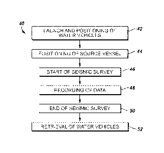
to Fig. 2, a workflow 40 for conducting a seismic survey includes the steps
of: launching and
positioning of water vehicles in a survey region 42; positioning the source
vessel 44; starting
a seismic survey 46; recording seismic data 48; ending the seismic survey 50;
and retrieving
the water vehicles 52.
Several seismic survey geometries may be employed via the workflow using the
water
vehicles 10 as seismic data acquisition platforms. For example, Fig. 3A
depicts a survey
geometry in which the water vehicles 10 advance along a substantially linear
path, while a
source vessel 60 shoots along a sail pattern that is substantially
perpendicular to the paths of
the water vehicles. It is to be appreciated that in practice, the water
vehicles 10 do not travel
8
CA 02811492 2013-03-15
WO 2012/036814 PCT/US2011/047791
along a substantially linear path, but rather there is likely some deviation
from the linear path.
The water vehicles 10 preferably have spacing similar to towed streamers, such
as 100 meter
intervals in the crossline direction. The water vehicles 10 may move at a
speed (e.g., 1 knot
or less) considerably different from the source vessel (e.g., 5 knots or
more). This not only
facilitates the survey geometry, but also allows the smaller water vehicles 10
to conserve
more fuel relative to the faster and larger source vessel 60. When the source
vessel 60 has
reached a boundary of the area under survey, it may turn around and continue
shooting along
a line perpendicular to the water vehicles' 10 sail direction.
Fig. 3B illustrates another possible geometry in which the water vehicles 10
advance
along a substantially linear path, while the source vessel 60 shoots along a
path either
perpendicular or generally transverse to the water vehicles' path. Fig. 3C
illustrates yet
another possible geometry in which the source vessel 40 shoots along a path
substantially
parallel to the path of the water vehicles 10. Fig. 3D illustrates another
geometry in which
the source vessel 60 shoots in a substantially circular configuration in and
around a survey
area of the water vehicles 10. Elliptical configurations are also
contemplated. At the
conclusion of the seismic survey, the source vessel 40 may collect the water
vehicles 10 to
permit data retrieval and recharging of the water vehicles, if necessary.
To facilitate seismic surveying, the water vehicles 10 may have an onboard
positioning system. This may include conventional GPS systems for surface
units and/or
short base line acoustic positioning systems for positioning the streamer 14
(Fig. 1) relative to
the water vehicle 10. Other positioning systems may utilize one or more
compasses with or
without accelerometers to determine streamer shape and location relative to
the water vehicle
10.
Multiple AUV's may employ relative positioning methods such as RTK or acoustic
distance measuring systems. Radar positioning methods might also be used, with
a master
9
CA 02811492 2014-12-23
79700-86
vessel or platform using micro-radar systems for locating one or more gliders
relative to its
known positing.
Referring to Fig. 4, in ,some embodiments, the water vehicles 10 may be
deployed
together with a conventional towed array seismic survey system 70 in which
conventional
seismic streamers 72 are towed through the water column to collect seismic
data. In such
embodiments, the water vehicles 10 may provide support by collecting and
providing data
useful for facilitating operation of the seismic survey. For example, the
water vehicles 10
may be used for measuring current in real time using an ADCP or other current
measurement
device, or alternatively comparing its speed over ground to a water speed
measurement. Such
current data may be transmitted to a conventional survey vessel 74 (e.g., via
communication
unit 32 (Fig. 1)) operating in the area to allow the vessel to anticipate the
current velocity it
might encounter while traversing down a survey line. Knowledge of the current
ahead can be
used to control the vessel speed and rudder, and streamer and source steering
devices,
allowing a smooth transition from one current regime to the next.
The water vehicles 10 according to the present disclosure may also be used
with
conventional towed arrays to aid in positioning of the streamers 72. In such
embodiments,
the water vehicles 10 may provide one or more Global Navigation Satellite
Systems (GNSS)
Earth Centered Earth Fixed (ECEF) reference points. For example, the water
vehicles 10
may be equipped with GPS devices. The deployed streamers 72 may be equipped
with
acoustic positioning systems, such as the IRMA system described in U.S. Patent
No.
5,668,775. Sensors in or on the streamers may be
positioned with respect to a short baseline (sbl) or ultra short baseline
(usbl) transducer head
mounted on the wave glider platform with reference to the GNSS antenna. To
further
improve the position accuracy of the streamers 72, the water vehicles 10 in
the survey area
may become part of the acoustic positioning system. In this regard, the water
vehicles 10
CA 02811492 2013-03-15
WO 2012/036814 PCT/US2011/047791
may record the acoustic signals emitted by the acoustic sources in the
streamers 72 and
transmit those recordings to the vessel 74. The water vehicles 10 may also
carry additional
acoustic sources whose signals are recorded by the streamers 72. The recorded
acoustic
signals from the streamers 72 and the water vehicles 10 may then be combined
and used to
determine an even more accurate position of the streamers and the water
vehicles. In some
embodiments, the water vehicles 10 may be deployed within the spread of
streamers 72 if risk
of entanglement is low. Otherwise the water vehicles may sail outside the
streamer spread as
illustrated in Figure 4.
Referring to Fig. 5, in some embodiments, the water vehicles 10 may be
deployed in
conjunction with a 2D seismic survey in which only one streamer 72 is towed
behind the
vessel 74. In such surveys, obtaining accurate position information is more
challenging.
Prior art solutions involve measuring the streamer orientation at regular
intervals using
compasses inside the streamer. According to the principles of the present
disclosure, the
water vehicles 10 may be deployed with acoustic positioning equipment as
previously
described and at a position offset from the sail line of the streamer 72. The
acoustic
positioning equipment on the water vehicles 10 is able to both receive and
transmit acoustic
signals. Accordingly, methods of triangulation may be used to accurately
determine streamer
position and shape. This more accurate streamer position information may be
used to
determine the further course of the vessel and streamer and for correcting to
such position.
The streamer 72 may also be fitted with steerable birds that when combined
with new
position information would allow for more accurate positioning of the streamer
in response to
currents and feathering.
In still other embodiments, and with reference to Fig. 6, one or more water
vehicles
may be deployed in the vicinity of a known oil and/or gas reservoir 100 and
associated
drilling rig 102 for the purposes of monitoring the reservoir. Reservoir
monitoring is a
11
CA 02811492 2013-03-15
WO 2012/036814 PCT/US2011/047791
common practice in the oilfield industry to assess the continued viability of
the reservoir.
However, conventional towed array systems are ill-equipped to provide
reservoir monitoring
as the length and size of such spreads can interfere with the drilling rig and
associated supply
vessels operating in the area. According to the principles of the present
disclosure, several
water vehicles 10 may be deployed with associated mini-streamers 14. Such
vehicles 10
allow for closer deployment to the survey region of interest (e.g., reservoir
100) and also
reduce risks associated with streamer entanglement. Indeed, in embodiments
where the water
vehicles 10 are designed to ascend and descend within the water column, risk
of
entanglement or collision with the rig 102 and/or supply vessels may be
further mitigated.
Also, a combination of surface vehicles 10 and underwater vehicles 10 may be
simultaneously deployed for the purposes of permanent reservoir monitoring.
For example,
the surface vehicles 10 may be deployed in a vertical cable arrangement as
shown in Fig. 1,
while the underwater vehicles 10 may provide infill coverage complementary to
the surface
vehicles. In such embodiments, the underwater vehicles 10 may tow streamers in
a
substantially horizontal direction, or the seismic sensors may be coupled to
the underwater
vehicle itself, thus eliminating the need for streamers. Of course, other
complementary
geometries are contemplated, such as using the surface vehicles 10 to tow
substantially
horizontal streamers, while the underwater vehicles 10 record seismic data
(with or without
streamers) in a substantially vertical direction in the water column.
The vehicles 10 may be deployed in conjunction with an energy source that
provides
useful data for seismic purposes. For example, such an energy source may
include a seismic
source (e.g., seismic source 18 in Fig. 1), drilling induced acoustic pressure
waves, or
production induced acoustic pressure waves such as might result from water or
gas injection.
In embodiments where seismic sources are deployed with the water vehicles 10,
the seismic
source may be a conventional air gun, marine vibrator, or non-traditional
environmentally
12
CA 02811492 2014-12-23
79700-86
friendly source. Marine vibrators and non-conventional environmentally
friendly sources are
characterized in that they have a lower amplitude than conventional airguns.
The seismic
sensors towed by, or otherwise coupled to, the water vehicles 10 are better
suited for
recording lower amplitudes due to the low water relative speeds of the water
vehicles that
avoid the water flow induced pressure waves that impact the hydrophones of
conventional
towed array systems. Further, the water vehicles 10 are better suited for
recording the Iowa
amplitude drilling and production induced noise produced in the vicinity of
the reservoir 100.
The combination of the relatively quiet towing platform of the water vehicles
10 and seismic
signal emission without the need for a source towing vessel is a significant
efficiency gain for
reservoir monitoring. Such seismic monitoring could be performed continuously
during the
life of the reservoir to calibrate reservoir models and generally give
information that will
increase production.
In some embodiments, the water vehicle 10 may be used to monitor the presence
of
marine mammals in an area where seismic source signals are being generated.
The
hydrophones 12 towed by the water vehicles 10 may be used to record data in
two separate
sampling frequencies ¨ one being a survey sampling frequency associated with
acoustic
signals emitted by the seismic source, and the other being a detection
sampling frequency
associated with marine mammal vocalizations. Additional details regarding such
a marine
mammal detection system are further described in U.S. Patent Publication No.
2010/0067326.
In other embodiments, the water vehicles 10 and
associated mini-streamers 14 may be dedicated to marine mammal monitoring and
thus the
sensors 12 are designed for and used exclusively to detect marine mammal
vocalizations. In
still other embodiments, the streamers contain sensors designed for seismic
signal recording
and additional specially designed marine mammal sensing devices together.
13
CA 02811492 2014-12-23
79700-86
In still other embodiments, the water vehicles 10 may be deployed to engage in
sound
verification studies to assess the zone of impact associated with firing of
seismic sources
during the survey. Such studies are typically performed prior to the start of
a seismic survey
and are aimed at calculating a zone of impact based on numerical models for
the survey area,
including water depth, ocean bottom properties and water properties. By
assessing the zone
of impact, the area may be cleared prior to beginning the seismic survey. The
assessed zone
of impact may be verified by shooting a line into an array of hydrophones
disposed
substantially perpendicular to the shooting line. Thus, measurements at
different offsets may
provide the desired verification. The array of hydrophones may be deployed via
the water
vehicles 10, thus obviating the need for deploying more costly chase and/or
supply vessels to
perform the sound verification studies. Moreover, given the relatively small
surface area of
the water vehicles 10, such verification studies may be performed in real
time, thus avoiding
delays of the start of the seismic survey.
Although specific embodiments of the invention have been disclosed herein in
some
detail, this has been done solely for the purposes of describing various
features and aspects of
the invention, and is not intended to be limiting with respect to the scope of
the invention. It
is therefore contemplated that various substitutions, alterations, and/or
modifications,
including but not limited to those implementation variations which may have
been suggested
herein, may be made to the disclosed embodiments without departing from the
scope of the invention as defined by the appended claims which follow.
14