Note : Les descriptions sont présentées dans la langue officielle dans laquelle elles ont été soumises.
CA 02823859 2013-10-16
AUGMENTATION OF PLACE RANKING
USING 3D MODEL ACTIVITY IN AN AREA
[0001] <deleted>
BACKGROUND OF THE INVENTION
[0002] Various network-based search applications allow
users to enter one or more search terms and in response,
receive a list of search results. These
search services may
also allow users to conduct "local" searches for information
associated with a particular geographic location or area. A
"local" search or a search with "local" intent may include
search terms which provide a geographic context or constraint
for a query. For
example, a user may use the terms "pizza,
Miami" in a map search. The "Miami" gives the query a local
context, and accordingly, the user may be provided with search
results related to pizza in the area of Miami.
Similarly, a
user may use the terms "empire state building, New York" in a
web search. Again,
the terms "New York" give the query a
local context.
[0003] These services use numerous different types of
ranking algorithms to ensure that the search results are both
relevant to the user's query and displayed in a useful way.
For example, some systems rank results based on the relevance
to the search query as well as the reliability and safety of
the search results. These
search services may also rank and
display search results according to the prominence of an
entity or entities associated with the search result. For
example if a user searches for "coffee house Seattle", the
search application may also display a list of prominent (or
-1-
CA 02823859 2013-08-07
WO 2012/088026 PCT/US2011/066009
well known, respected or important) websites or businesses
based on the geographic location, here, Seattle.
[0004] Some
services allow users to upload and share three-
dimensional ("3D") models of various objects such as the
interior or exterior of buildings, stadiums, ships, vehicles,
trees, or terrain (for example, the Grand Canyon), etc. The
objects may be associated with various types of information
such as titles, descriptive data, user reviews, points of
interest ("POI"), business listings, etc. Many of the objects
and the models themselves, may be geolocated or associated
with a geographic location such as an address or geolocation
coordinates. Models may also be categorized. For example, a
model of a skyscraper may be associated with one or more
categories such as skyscrapers, buildings in a particular
city, etc. In this regard, a user may search the database for
models, for example, based on the associated title, geographic
location, description, object type, collection, physical
features, etc.
[0005] Once a user
has selected a 3D model, the user may
interact with the model. For example,
a user may query the
database for "the Eiffel Tower" and in response receive a list
of search results including various models of the Eiffel
Tower, in Paris, France, as well as other objects associated
with or indexed by the search terms. Once a user has selected
an object, for example, by clicking on a search result, the
user may, among other actions, download, view, rotate, or
comment on the model.
[0006] Services may also allow users to search, for
example, for businesses or geographic locations on a world
map. In response to a search query, the service may provide a
map identifying, among other information, a 3D model or a link
2
CA 02823859 2013-08-07
WO 2012/088026 PCT/US2011/066009
to a 3D model of a 3D model database. Again, the
user may
interact with the 3D model, for example, by clicking on the
model.
BRIEF SUMMARY OF THE INVENTION
[0007] Aspects of
the invention relate generally to ranking
geographic locations based on perceived user interest. More
specifically, a database of three-dimensional models of
buildings or other architectural features may be used to
determine the level of user interest in a particular location
and accordingly rank, for example, geographic locations or web
or map search results with local intent. For
instance,
various signals such as the number of models created by users
for a particular location, the number of clicks or requests
for the models of the particular location, the number of
points of interest (POIs) contained within or associated with
the models associated with the particular geographic location,
number of categories associated with a model associated with
the geographic location, number of embedded views or views of
the models associated with the particular location on other
web sites, and the age of the models associated with the
particular geographic location.
[0008] One aspect
of the invention provides a computer-
implemented method. The method
includes storing a list of
geographic locations; accessing a database of 3D models of
objects, a plurality of the 3D models each being associated
with a respective geographic location of the list of
geographic locations; a processor determining a user interest
value for each particular geographic location of the list of
geographic locations based on whether the particular
geographic location includes the respective geographic
location of a given one of the plurality of 3D models, wherein
3
CA 02823859 2013-08-07
WO 2012/088026 PCT/IJS2011/066009
each user interest value is indicative of user interest in the
particular geographic location; and ordering, by the
processor, the list of geographic locations based on the
determined values to produce an ordered list of geographic
locations.
[0009] In one
example, the user interest value for the
particular geographic location is based on a number of 3D
models associated with respective geographic locations
included in the particular geographic location. In another
example, the method also includes receiving user requests for
one or more 3D models associated with respective geographic
locations included in the particular geographic location for a
period of time, and each user interest value is based on a
number of user requests received during the period of time.
In another example, each of the plurality of 3D models is
associated with one or more points of interest, and each user
interest value is based on a number of the points of interest
associated with the 3D models associated with a respective
geographic location that is included in the particular
geographic location. In another
example, each of the
plurality of 3D models is associated with one or more user
designated categories of objects, and each user interest value
is based on a number of the categories associated with the 3D
models associated with a respective geographic location that
is included in the particular geographic location. In another
example, the method also includes scanning a plurality of web
sites to identify views of the 3D model associated with the
respective geographic location included in the particular
geographic location; and wherein the user interest value for
the particular geographic location is based on the number of
identified views. In another
example, each particular 3D
4
CA 02823859 2013-08-07
WO 2012/088026 PCT/US2011/066009
model of the plurality of 3D models is associated with a time
value defining the age of the particular 3D model, and each
user interest value is based on the time value associated with
the 3D models associated with a respective geographic location
that is included in the particular geographic location. In
another example, the method also includes receiving a search
query from a client device; identifying a list of search
results based on the ordered list of geographic locations; and
transmitting the search results to be displayed on a display
of the client device based on the ordered list of geographic
locations. In another
example, the method also includes for
each particular geographic location of the list of geographic
locations, determining a weighted sum based on the determined
value associated with the particular geographic location, and
wherein ordering the list of geographic locations is also
based on the weighted sums.
[0010] Another
aspect of the invention provides a computer.
The computer includes memory storing a list of geographic
locations and a database of 3D models of objects. The memory
also stores a plurality of the 3D models each being associated
with a respective geographic location of the list of
geographic locations. The computer also includes a processor
coupled to the memory. The processor is operable to determine
a user interest value for each particular geographic location
of the list of geographic locations based on whether the
particular geographic location includes the respective
geographic location of a given one of the plurality of 3D
models, wherein each user interest value is indicative of user
interest in the particular geographic location; and order the
list of geographic locations based on the determined values to
produce an ordered list of geographic locations.
CA 02823859 2013-08-07
WO 2012/088026 PCT/US2011/066009
[ 0 0 1 1 ] In one
example, the processor is also operable to
determine the user interest value for the particular
geographic location based on a number of 3D models associated
with a respective geographic location included in the
particular geographic location. In another
example, the
processor is also operable to receive user requests for one or
more 3D models associated with respective geographic locations
included in the particular geographic location for a period of
time; and determine each user interest value based on a number
of user requests received during the period of time. In
another example, each of the plurality of 3D models is
associated with one or more points of interest, and the
processor is further operable to determine each user interest
value based on a number of the points of interest associated
with the 3D models which are associated with a respective
geographic location that is included in the particular
geographic location. In another
example, each of the
plurality of 3D models is associated with one or more user
designated categories of objects, and the processor is further
operable to determine each user interest value based on a
number of the categories associated with the 3D models which
are associated with a respective geographic location that is
included in the particular geographic location. In another
example, the processor is also operable to scan a plurality of
web sites to identify views of the 3D model associated with a
respective geographic location included in each particular
geographic location; and the processor is also operable to
determine each user interest value for each particular
geographic location based on the number of identified views.
In another example, each particular 3D model of the plurality
of 3D models is associated with a time value defining the age
6
CA 02823859 2013-08-07
WO 2012/088026 PCT/US2011/066009
of the particular 3D model, and the processor is further
operable to determine each user interest value based on the
time value associated with the 3D models associated with a
respective geographic location that is included in each
particular geographic location. In another
example, the
processor is operable to receive a search query from a client
device; identity a list of search results based on the ordered
list of geographic locations; and transmit the search results
to be displayed on a display of the client device based on the
ordered list of geographic locations. In another example, the
processor is also operable to, for each particular geographic
location of the list of geographic locations, determine a
weighted sum based on the determined value associated with the
particular geographic location, and wherein ordering the list
of geographic locations is also based on the weighted sums.
BRIEF DESCRIPTION OF THE DRAWINGS
[0012] FIGURE 1 is
a functional diagram of a system in
accordance with an aspect of the invention.
[0013] FIGURE 2 is
a pictorial diagram of a system in
accordance with an aspect of the invention.
[0014] FIGURE 3 is
an exemplary flow diagram in accordance
with an aspect of the invention.
[0015] FIGURE 4 is
an exemplary screen shot in accordance
with an aspect of the invention.
[0016] FIGURE 5 is another exemplary screen shot in
accordance with an aspect of the invention.
[0017] FIGURE 6 is
a further exemplary screen shot in
accordance with an aspect of the invention.
[0018] FIGURE 7 is another exemplary flow diagram in
accordance with an aspect of the invention.
7
CA 02823859 2013-08-07
WO 2012/088026 PCT/US2011/066009
[0019] FIGURE 8 is
a further exemplary flow diagram in
accordance with an aspect of the invention.
[0020] FIGURE 9 is
yet another exemplary flow diagram in
accordance with an aspect of the invention.
[0021] FIGURE 10 is
an exemplary flow diagram in accordance
with an aspect of the invention.
[0022] FIGURE 11 is
another exemplary flow diagram in
accordance with an aspect of the invention.
[0023] FIGURE 12 is
a further exemplary flow diagram in
accordance with an aspect of the invention.
[0024] FIGURE 13 is
a graphical representation of data in
accordance with an aspect of the invention.
[0025] FIGURE 14 is
yet another exemplary flow diagram in
accordance with an aspect of the invention.
DETAILED DESCRIPTION
[0026] As shown in
FIGURES 1-2, a system 100 in accordance
with one aspect of the invention includes a computer 110
containing a processor 120, memory 130 and other components
typically present in general purpose computers.
[0027] The memory
130 stores information accessible by
processor 120, including instructions 132, and data 134 that
may be executed or otherwise used by the processor 120. The
memory 130 may be of any type capable of storing information
accessible by the processor, including ,a computer-readable
medium, or other medium that stores data that may be read with
the aid of an electronic device, such as a hard-drive, memory
card, flash drive, ROM, RAM, DVD or other optical disks, as
well as other write-capable and read-only memories. In that
regard, memory may include short term or temporary storage as
well as long term or persistent storage. Systems and methods
in accordance with aspects of the invention may include
8
CA 02823859 2013-08-07
WO 2012/088026 PCT/US2011/066009
different combinations of the foregoing, whereby different
portions of the instructions and data are stored on different
types of media.
[0028] The
instructions 132 may be any set of instructions
to be executed directly (such as machine code) or indirectly
(such as scripts) by the processor. For example,
the
instructions may be stored as computer code on the computer-
readable medium. In that regard, the terms "instructions" and
"programs" may be used interchangeably herein. The
instructions may be stored in object code format for direct
processing by the processor, or in any other computer language
including scripts or collections of independent source code
modules that are interpreted on demand or compiled in advance.
Functions, methods and routines of the instructions are
explained in more detail below.
[0029] The data 134
may be retrieved, stored or modified by
processor 120 in accordance with the instructions 132. For
instance, although the architecture is not limited by any
particular data structure, the data may be stored in computer
registers, in a relational database as a table having a
plurality of different fields and records, XML documents or
flat files. The data may also be formatted in any computer-
readable format. By further way of example only, image data
may be stored as bitmaps comprised of grids of pixels that are
stored in accordance with formats that are compressed or
uncompressed, lossless or lossy, and bitmap or vector-based,
as well as computer instructions for drawing graphics. The
data may comprise any information sufficient to identify the
relevant information, such as numbers, descriptive text,
proprietary codes, references to data stored in other areas of
the same memory or different memories (including other network
9
CA 02823859 2013-08-07
WO 2012/088026 PCT/US2011/066009
locations) or information that is used by a function to
calculate the relevant data.
[0030] The
processor 120 may be any conventional processor,
such as processors from Intel Corporation or Advanced Micro
Devices.
Alternatively, the processor may be a dedicated
controller such as an ASIC. Although
FIGURE 1 functionally
illustrates the processor and memory as being within the same
block, it will be understood by those of ordinary skill in the
art that the processor and memory may actually comprise
multiple processors and memories that may or may not be stored
within the same physical housing. For example, memory may be
a hard drive or other storage media located in a server farm
of a data center. Accordingly, references to a processor, a
computer, or a memory will be understood to include references
to a collection of processors, computers, or memories that may
or may not operate in parallel.
[0031] The computer
110 may be at one node of a network 150
and capable of directly and indirectly receiving data from
other nodes of the network. For example,
computer 110 may
comprise a web server that is capable of receiving data from
client devices 160 and 170 via network 150 such that server
110 uses network 150 to transmit and display information to a
user on display 165 of client device 170. Server 110 may also
comprise a plurality of computers that exchange information
with different nodes of a network for the purpose of
receiving, processing and transmitting data to the client
devices. In this
instance, the client devices will typically
still be at different nodes of the network than any of the
computers comprising server 110.
[0032] Network 150,
and intervening nodes between server
110 and client devices, may comprise various configurations
CA 02823859 2013-08-07
WO 2012/088026 PCT/US2011/066009
and use various protocols including the Internet, World Wide
Web, intranets, virtual private networks, local Ethernet
networks, private networks using communication protocols
proprietary to one or more companies, cellular and wireless
networks (e.g., WiFi), instant messaging, HTTP and SMTP, and
various combinations of the foregoing. Although
only a few
computers are depicted in FIGURES 1-2, it should be
appreciated that a typical system can include a large number
of connected computers.
[0033] Each client
device may be configured similarly to
the server 110, with a processor, memory and instructions as
described above. Each client
device 160 or 170 may be a
personal computer intended for use by a person 191-192, and
have all of the components normally used in connection with a
personal computer such as a central processing unit (CPU) 162,
memory (e.g., RAM and internal hard drives) storing data 163
and instructions 164, an electronic display 165 (e.g., a
monitor having a screen, a touch-screen, a projector, a
television, a computer printer or any other electrical device
that is operable to display information), end user input 166
(e.g., a mouse, keyboard, touch-screen or microphone). The
client device may also include a camera 167, accelerometer,
speakers, a network interface device, a battery power supply
169 or other power source, and all of the components used for
connecting these elements to one another.
[0034] As shown in
FIGURE 1, the client devices may also
include geographic position component 168 to determine the
geographic location and orientation of the device. For
example, client device 170 may include a GPS receiver to
determine the device's latitude, longitude and altitude
position. Thus, as the client device changes location, for
11
CA 02823859 2013-08-07
WO 2012/088026 PCT/US2011/066009
example by being physically moved, the CPS receiver may
determine a new current location. The component 168 may also
comprise software for determining the position of the device
based on other signals received at the client device 1/0, such
as signals received at a cell phone's antennas from one or
more cell phone towers it the client device is a cell phone.
[0035] Although the
client devices 160 and 1/0 may each
comprise a full-sized personal computer, they may
alternatively comprise mobile devices capable of wirelessiy
exchanging data, including position information derived from
position component 168, with a server over a network such as
the Internet. By way of example only, client device 160 may
be a wireless-enabled PDA or a cellular phone capable of
obtaining information via the Internet. The user may
input
Information using a small keyboard (in the case of a
Blackberry-type phone), a keypad (in the case of a typical
cellular phone) or a touch screen (in the case of a PDA).
[0036] Data 134 of
server 110 may include a database 136 of
3D models of various objects. These 3D
objects may be
associated with data provided by the model's creator (or
uploading user) or other users. For example, a model may be
associated with one or more categories, geographic locations,
descriptions, user reviews, etc. The models
may also be
associated with user-designated collections. For example,
when a user uploads a new model to the database, the user may
designate the model as part of one or more collections, such
as "mid-century modern" or "stuff I like." As a result, the
new model may also be associated with other models also
associated with the same collection. This information may be
used to identify, index, and query the models.
12
CA 02823859 2013-08-07
WO 2012/088026 PCT/US2011/066009
[0037] If a
particular object is geolocated (or associated
with a geographic location), the 3d object data may also
include a number of POIs contained within the object or very
close to its perimeter. POIs may include, for example,
businesses (such as retail locations, gas stations, hotels,
supermarkets, restaurants, etc.), schools, federal or state
government buildings, parks, monuments, statues, bridges, etc.
This data may be also used to index the objects and provide
search results in response to a user query of the database.
[0038] Server 110
may access map information 138, at least
a portion of which may be transmitted to the client device.
For example, the server may store map tiles, where each tile
is a map image of a particular geographic area. A single tile
may cover an entire region, such as a state, in relatively
little detail and another tile may cover just a few streets in
high detail. In that regard, a single geographic point may be
associated with multiple tiles, and a tile may be selected for
transmission based on the desired level of zoom. The map
information is not limited to any particular format. For
example, the data may comprise street maps, satellite images,
or a combination of these, and may be stored as vectors
(particularly with respect to street maps), bitmaps
(particularly with respect to satellite images), etc.
[0039] The map
information 138 may include various types of
geolocated information, such as, buildings, roadways,
waterways, POIs, and other features which may be used to
display a map of a given location.
[0040] The map
information may also include representative
3D objects selected from database 136. For example, there may
be a plurality of models of the "Eiffel Tower" stored in
database 136. A particular
3D model may be selected to
13
CA 02823859 2013-08-07
VM3 2012/088026 PCT/US2011/066009
represent the Eiffel Tower at the map location of Paris,
France. The selected model may be selected manually or by the
server based on various criteria including, for example,
question and answer sessions with the model's designer, the
level of accuracy and detail, the tile size, and even how fast
the model may load on a client device when requested from the
server. The model
selected to represent an object at a
particular geographic location may change over time as new
models are generated and uploaded by users.
[0041] The various
map tiles, vectors, etc. may each be
associated with geographical locations, such that the server
110 and/or a client device are capable of selecting,
retrieving, transmitting, or displaying one or more tiles in
response to receiving a geographical location. For example,
the client device may transmit a request to the server. The
server may identify relevant information and transmit the
information to the client device. The client
device may
receive the relevant information and use it to render a map
image on a display of the client device.
[0042] The server may also access search content 140. In
addition to querying the map information 138, the server may
also access web content and other Information in response to a
user request for information.
[0043] Data 134 may
also include a list of geographic
locations 142. This information may be stored as part of map
information 138 or independent of the map information. Each
particular geographic location of the list of geographic
locations may be associated with a user interest value based
on the perceived user interest in 3D models associated with
the particular geographic location. As described
in more
detail below, these values may be used, for example, to rank
14
CA 02823859 2013-08-07
MO 201/(088026 PCT/US2011/066009
and order the list of geographic locations or search results
associated with the geographic locations.
[0044] Various
operations in accordance with aspects of the
invention will now be described. It should also be understood
that the following operations do not have to be performed in
the precise order described below. Rather, various steps can
be handled in a different order or simultaneously.
[0045] The server
may use 3D object data to quantify user
interest in a particular geographic location. In one example,
the server may determine the number of models of a particular
geolocated object which have been uploaded by users and use
this number as an indicator of user interest. For example,
more 3D models of a particular geolocated object or location
may imply a greater user interest in that entity or location.
[0046] In another
example, the server may use a threshold
value based on the number of co-located models as an indicator
of user interest. In one
example, the number of co-located
models may be used as a weighted factor. In another example,
if the number of models of an object or containing the object
is greater than the threshold value, for example, more than 5,
the location may be considered "interesting." In other words,
if more users are creating and uploading 3D models associated
with a particular geographic location, the more likely other
user may be interested in the particular geographic location.
It will be understood that as the total number of models
Increases, this "threshold" number of models may also
increase. If there are
zero, one or very few models of a
particular location, the interest in a particular location may
be assumed to be much lower. For example,
database 136 may
Include twenty different models of or which contain the Eiffel
Tower but only one model of the Hopital he Longjumeau (both in
CA 02823859 2013-08-07
WO 2012/088026 PCT/US2011/066009
Paris, France) . In the
present example, because of the
relatively high number of models of the Eiffel Tower, user
interest in these 3D objects and the user interest indicator
value for this location may be higher than those associated
with the Hopital de Longjumeau.
[0047] As shown in
the exemplary flow diagram 300 of FIGURE
3, the server receives one or more 3D models of an object at
block 302. The object
is associated with a particular
geographic location. At block 304, the server identifies the
number of received (uploaded or stored) 3D models associated
with the particular geographic location. At block
306, the
server determines an indicator value, indicative of the level
of user interest in a geographic location, for the particular
geographic location based on the number of received 3D models.
[0048] In another
example, the server may use the number of
clicks on a particular geolocated model of an object over a
period of time as an indicator of user interest in the
particular geographic location. For example, a client device
may request map information for New York City. In the example
of FIGURE 4, the user enters a local search 410 for Business
A, NY. The server may query the map information and return a
map 420 of New York City, various search results 430, and
related map markers 440. The map may
also include 2D or 3D
representations, images, photos, etc. of buildings 450,
roadways 460, intersection 470, etc. The user may select the
model by clicking on a 2D representation or image or a
building to view the model more closely or request additional
information about the Empire State Building. For example, as
shown in FIGURE 5, the user may maneuver a mouse icon 505 over
and/or click on a building 510 and receive a popup 520 with a
view of a 3D model. The user may select model 530 by clicking
16
CA 02823859 2013-08-07
WO 2012/088026 PCT/US2011/066009
on the model using mouse 505. In response,
the user may be
presented with a display of the 3D model and various other
information as shown in FIGURE 6.
[0049] The number
of times a particular representative
model has been selected for a given period of time may be
recorded and stored by the server. Each
"selection" or
"click" event may be associated with the model and stored, for
example as a running tally or average. Preferably,
privacy
protections are provided for the user data including, for
example, anonymization of personally identifiable information,
aggregation of data, filtering of sensitive information,
encryption, hashing or filtering of sensitive information to
remove personal attributes, time limitations on storage of
information, or limitations on data use or sharing.
Preferably, data is anonymized and aggregated such that any
individual user data is not revealed.
[0050] As an
example, model A may receive an average of 100
clicks per day for the last 30 days, whereas model B may
receive an average of 120 clicks per day for the last 10 days.
In another example, the same average number of clicks per day
may be received if model A receives a total of 1000 clicks in
the last 10 days and model B receives a total of 1200 clicks
in the last 10 days. The greater
the number of clicks on a
particular representative model over a given period of time,
the greater the level of user interest (and indicator value)
of the geographic location associated with the model.
[0051] As noted
above, the representative model selected
for a particular geographic location may change over time.
Thus, the count may be recorded for a particular geographic
location and may span multiple models. For example, model A
may be selected to represent a given location from time t=0 to
17
CA 02823859 2013-08-07
WO 2012/088026 PCT/US2011/066009
time t=5 days, and model B may replace model A as the selected
model between time t=5 days and t=10 days. In order to
determine the number of clicks for the period t=0 to t=10, the
server may record the click data associated with model A and
model B and combine these counts together. The greater
the
number of clicks on a given model or chain of models, the
greater the level of importance or user interest in the
geographic location. Again, the
server may use this
information to determine the level of user interest or an
indicator value for search results associated with the object
or the object's geographic location.
[0052] As shown in
the exemplary flow diagram 100 of FIGURE
7, the server receives, from a plurality of requesting client
devices, requests for a map of a geographic area at block 702.
In response, the server transmits the requested map of the
geographic area to the requesting client devices at block 704.
The server also transmits information identifying a 3D model
of an object associated with a particular geographic location
within the geographic area of the transmitted map. The server
then receives, from one or more of the client devices, one or
more requests for the 3D model at block 706 (for example,
where the user has clicked on the information identifying a 3D
model). The server identifies the number of received requests
for the 3D model received over a period of time at block 708.
The server then determines an indicator value for the
particular geographic location based on the number of received
requests for the 3D model for the period of time at block 710.
[0053] In addition
to the number of clicks a given model
receives, the server may also determine a user interest value
based on various other criteria associated with user actions
such as how often a model is requested from database 136 (for
18
CA 02823859 2013-08-07
WO 2012/088026 PCT/US2011/066009
example by entering a query into search box 610 and selecting
a resulting 3D model or by selecting the model as shown in
FIGURE .5), the average length of time a model or the
description associated with a model is viewed by users (for
example, how long the user views the model 620, description
630, etc.), etc. Again the greater these values, the greater
the user interest in the model, and the greater the perceived
level of user interest and indicator value for the geographic
location.
[0054] As shown in
the exemplary flow diagram 800 of FIGURE
8, the server receives a request for a particular 3D model,
for example, where a user selects or clicks on the 3D model in
a list of search results as shown in block 802. The server
identifies the number of received requests for the 3D model at
block 804. The server then determines an indicator value for
the particular geographic location based on the number of
received requests for the 3D models at block 806.
[0055] In a further
example, the server may use the number
POI associated with, nearby, or contained within the bounds of
a geolocated model (based on its map location) as an indicator
of user interest in the particular geographic location. For
example, a particular 3D object may be associated with a given
geographic location. The server may identify one or more POIs
of the map information at or near the given geographic
location. In one
example, if the geolocated object is a
building or other structure, an identified POI may be located
within the building (at the same address), in the courtyard of
the building, or next to the building. The
identified POIs
may be associated with the 3D object and this association may
be stored as described above.
19
CA 02823859 2013-08-07
WO 2012/088026 PCT/US2011/066009
[0 056 ] It a
particular location is associated with a
relatively high number of POI, the location may be considered
more interesting to users and thus be associated with a
greater interest value. For example,
a first building
including only a bookstore business may be considered less
interesting to users than a second building associated with a
coffee shop, a bookstore business, and a park. Thus, the
second building associated with three POIs may have a higher
perceived level of user interest (or indicator value) than
that of the first building associated with a single POI.
[0057] As shown in
the exemplary flow diagram 900 of FIGURE
9, the server identifies a number of points of interest
associated with a 3D model of an object associated with a
particular geographic location at block 902. A point of
interest may be associated with a 3D model, for example, if
the point of interest is contained within the boundaries of
the 3D model or the object or is located proximate to the
object. As shown in block 904, the server then determines an
indicator value for the particular geographic location based
on the number of points of interest associated with the 3D
model.
[0058] In yet
another example, the server may use the
number of collections or tags associated with a geolocated
model as an indicator of user interest in the particular
geographic location. For example,
users which designate a
model as part of a particular collection may be likely to do
so because the user admires the model and presumably the
geographic location of the real object. Models associated
with a relatively high number of collections, for example 5 or
more, may therefore have a higher level user interest and a
CA 02823859 2013-08-07
WO 2012/088026 PCT/US2011/066009
higher indicator value than models which are contained in very
few collections, or none at all.
[0059] As shown in
the exemplary flow diagram 1000 of
FIGURE 10, the server receives one or more 3D models of an
object associated with a particular geographic location at
block 1002. The server then receives, for each of the one or
more 3D models, one or more user defined collection
designations at block 1004. The server
then identifies the
number of collections associated with the one or more 3D
models at block 1006. The server then determines an indicator
value for the particular geographic location based on the
number of collections at block 1008.
[0060] In still a
further example, the server may use the
number of embedded views of a geolocated model as an indicator
of user interest in the particular geographic location.
Embedded views may be described as two-dimensional views or
images of a model displayed in various ways on a web site (as
opposed to views of the 3D model displayed in the context of
database 136). For example, a website advertising, promoting
or mentioning a particular 3D model may include a two
dimensional image of the 3D model as described above. The
server may provide the two dimensional views of the 3D model
to users upon request and thus identify the number of
requested images as well as embedded views. For example,
based on the URL used, when a user clicks to view an embedded
view of an image or the image is requested in order to be
displayed to a user, a particular servlet may receive a
request for the embedded views. For example, an embedded view
may take the form of: <iframe src="http: // a.com /3dwarehouse
/mini?mid=34cb74ce8e5a1ed9/d4896c8a58e0569&etyp=im&width=400&h
eight=300" frameborder="0" scrolling="no" marginheight="0"
21
CA 02823859 2013-08-07
WO 2012/088026 PCT/US2011/066009
marginwidth="0" width="400" height="300"></itrame> where as an
image of the model used in the database context may take the
form of <http: // a.com /3dwarehouse
/download?mid=34cb/4ce8ebaled91d4896c8a53e0569&rtyp=lt&ctyp=ot
her&ts=12862127/3000>. In this
example, the first URL uses
the "mini" servlet, and the second uses the "download"
servlet. Thus, based
on the type of servlet providing the
image, the server may identify whether the request is for an
embedded view and may record the number of requests.
[0061] The greater
the number of requests for embedded
views of a particular geolocated model, the greater the
presumed user interest value in the model as well as the
model's associated geographic location. Thus, the
level of
user interest or indicator value in the geographic location of
a model which appears in, for example 5 or more web sites, may
be higher than the user interest in the geographic location of
a model which appears in very few or no web sites.
[0062] As shown in
the exemplary flow diagram 1100 of
FIGURE 11, the server identifies a number of 2D views of a 3D
model associated with a particular geographic location at
block 1102. These
"views" may be included in various web
sites. The server then determines an indicator value for the
particular geographic location based on the number of 2D views
at block 1104.
[0063] In yet a
further example, the server may use the
length of time that a particular geographic location has been
associated with one or more geolocated models. For example,
the age, or how long a particular geolocated model has been
included in the database, may indicate the user interest or
importance of the associated geographic location. This may
be, for example, because at least one user thought an object
22
CA 02823859 2013-08-07
WO 2012/088026 PCT/US2011/066009
at the geographic location was interesting enough to create
and upload a 3D model. It a
particular geolocated model has
been included in the database for a relatively long period of
time, such as tour or more years, this may indicate a higher
level of user interest or indicator value for the geographic
location than another geographic location which has no
associated models or models which have existed for a much
shorter period of time, such as one year or less.
[0064] As shown in
the exemplary flow diagram 1200 of
FIGURE 12, the server receives a 3D model of an object
associated with a particular geographic location at block
1202. The server stores the 3D model for an amount of time at
block 1204. The server then determines an indicator value for
the particular geographic location based on the amount of time
the 3D model has been stored at block 1206.
[0065] The above examples of indicators and values
indicative of user interest may be used alone or in
combination, for example, to rank and order a list of
geographic locations. For example,
each particular location
of a given list of geographic locations may be associated with
a user interest value. The user interest value may indicate
the level of user interest in a particular location based one
or more of the factors determined from the 3D model data, etc.
described above.
[0066] The user
interest value may be used to rank the list
of geographic location or may simply be associated with the
geographic location and the association stored in memory
accessibly by the server. The values
may be determined
periodically or updated as the various indicator's
contributions to the value may change overtime. For example,
a process may be run periodically, such as each night, in
23
CA 02823859 2013-08-07
WO 2012/088026 PCT/US2011/066009
order to determine a user interest value for each geographic
location of the list of geographic locations. The user
interest value may be associated with each entity and stored.
The server may receive a query and in response, identify a
list of search results based on relevance to the query. The
server may also determine a relevancy-to-query value. For
each particular entity returned as a search result for a
query, the server may retrieve the stored user interest value
associated with the geographic location of each particular
entity. The user
interest values may be combined with the
respective relevance-to-query score for each search result in
the identified list of search results in order to determine
the ranking of the results. For example, if an entity X and
an entity Y include identical relevancy-to-query values for a
given query and are otherwise identical, the server may use
the user interest values to determine whether the entity X and
entity Y will be displayed, and if so, the order in which they
will be displayed to the user.
Alternatively, these values
may be computed by the server for a list of search results in
real time in response to receiving a search query and
identifying the list of search results.
[0067] The user
interest value may be based on one or more
of the indicators described above, such as the number of
models of a particular object; the number of clicks on a
particular geolocated model; criteria associated with user
actions; the number POI associated with, nearby, or contained
within the bounds of a geolocated model; and the length of
time that a particular geographic location has been associated
with one or more geolocated models. For example, if there are
multiple user interest signals being considered, the user
interest values may be combined by way of a mathematical
24
CA 02823859 2013-08-07
WO 2012/088026 PCT/US2011/066009
function so as to determine an aggregate user interest over
all of the plurality of user interest indicators.
[0068] One example
of this type of calculation may be a
weighted sum of the user interest indicators, where a greater
weight is given to stronger indicators of user interest. For
example, the weighted sum may be written as:
sum {i=0}^{i=N {user interest tactors1}{weight {user interest
factor il*fuser interest factor ill.
If the weights sum to 1, this may be a weighted average.
[0069] In one
example, a user creating a 3D model at a
location may be a stronger indicator of user interest than a
single user interacting with the same model. In this example,
the weighted user interest value for a particular model may
be:
(weight_lnumber of 3D models overlapping this one}*
number of 3d models overlapping this_one) + (weight {number of
interactions with the model in the last week}*
{number ot interactions with this model in the last week}.
The value of weight {number of 3D models over lapping this
one} may be .99, while the value of weight_{number of
interactions with the model in the last week) may be 0.01. In
this example, a single model associated with a geographic
location may indicate the same amount of user interest as 99
separate interactions with the model. Thus, it there is only
a single model and the model was interacted with 99 times, the
total user interest score may be calculated as: (0.99*1) +
(0.1*99) = 1Ø
[0070] In another
example, the weighted sum described above
may be passed through a thresholding nonlinearity such as a
sigmoid. This may be
illustrated using the program Matlab.
For example, a sigmoid may be generated using the following:
CA 02823859 2013-08-07
WO 2012/088026 PCT/US2011/066009
function y = sigmoid(x, shift, scale)
%SIGMOID returns the sigmoid function
%USAGE: y = sigmoid(x, shift, scale)
%Calculates 1 ./ (1 + exp(-((x-shitt)./scale)));
Y = 1 ./ (1 + exp(-((x-shift)./scale))).
In this example, "x" may be the linear combination of user
inputs (the weighted sum). Figure 13
depicts this sigmoid
where the shift has been set to 0.5 and the scale to 0.1.
[0071] As shown in
the exemplary flow diagram 1400 of
FIGURE 14, the server accesses a list of geographic locations
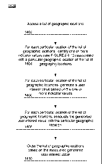
at block 1402. For each
particular geographic location, the
server identifies one or more indicator values (see, for
example, FIGURES 6-12) associated with the particular
geographic location and generates a user interest value based
on the identified one or more indicator values as shown in
block 1404 and 1406, respectively. The server associates the
user interest value with the respective geographic location of
the list of geographic locations at block 1408. The server
then orders the list of geographic locations based on the
respective user interest values as shown in block 1410.
[0072] In one example, a client device may request
information from the server. If the
request is a local
search, including a geographic search constraint as described
above, the server may select search results from the list of
geographic locations. As noted
above, the results may be
ranked in advance or ranked as a result of the search request.
The server may then identify the relevant search results, for
26
CA 02823859 2013-08-07
WO 2012/088026 PCT/US2011/066009
example, in descending order based on the associated user
interest values.
[0073] In another example, the user interest value may be
used to remove or reorder search results in order to reduce
spam search results. For example, a search for "empire state
building, new york" may return a list of search results
related to the true Empire State Building in New York city.
In addition, the results may also include "spam" results.
These spam results may contain text which refers to the
queried terms, but the spam may also be associated with a
location different from the geographic locations of the true
Empire State Building and the of the 3D models contained in
the database. Because the user interest value associated with
the correct location of the Empire State Building may be
relatively high as compared to the user interest value in the
spam result's geographic location, the spam result may be
removed or ranked very low so that it is either withheld from
search results provided to the requesting client device,
transmitted but not displayed on the display of the client
device, or displayed at a relatively low position (for
example, towards the bottom of a list of search results).
[0074] As these and other variations and combinations of
the features discussed above can be utilized without departing
from the invention as defined by the claims, the foregoing
description of exemplary embodiments should be taken by way of
illustration rather than by way of limitation of the invention
as defined by the claims. It will also be understood that the
provision of examples of the invention (as well as clauses
phrased as "such as," "e.g.", "including" and the like) should
not be interpreted as limiting the invention to the specific
27
CA 02823859 2013-08-07
WO 2012/088026 PCT/US2011/066009
examples; rather, the examples are intended to illustrate only
some of many possible aspects.
INDUSTRIAL APPLICABILITY
[0075] The present disclosure can be used to rank
geographic locations based on perceived user interest.
28