Note : Les descriptions sont présentées dans la langue officielle dans laquelle elles ont été soumises.
CA 02827070 2013-09-16
CG200046
INTERFERENCE NOISE ATTENUATION METHOD AND APPARATUS
BACKGROUND
TECHNICAL FIELD
[0001] Embodiments of the subject matter disclosed herein generally
relate to methods and systems for removing interference noise in seismic data
and, more particularly, to mechanisms and techniques for identifying and
subtracting seismic signals produced by a seismic source that is not part of
the
seismic survey.
DISCUSSION OF THE BACKGROUND
[0002] Seismic data acquisition and processing may be used to generate a
profile (image) of the geophysical structure under the ground (subsurface).
While
this profile does not provide an accurate location for oil and gas reservoirs,
it
suggests, to those trained in the field, the presence or absence of such
reservoirs. Thus, providing a high-resolution image of the subsurface is
important, for example, to those who need to determine where oil and gas
reservoirs are located.
[0003] Geophysical prospectors use a seismic source (e.g., air gun,
explosive, vibrators (in a marine or land context), etc.) to generate seismic
waves. The seismic waves propagate thorough the water (in the case of a
marine seismic survey) towards the sea bed. At the sea bed, some of the waves
enter the sea bed, some are reflected back to the sea surface while other are
refracted and continue to advance along the sea bed. Sooner or later most of
the
1
CA 02827070 2013-09-16
CG200046
waves return to the surface, either because they were reflected at various
interfaces under the sea bed (subsurface) or because they were refracted.
[0004] An array of seismic sensors are deployed either on the ocean
bottom (ocean bottom nodes or cables) or close to the water surface
(streamers).
In a towed streamer context, the sensors may be hydrophones and/or particle
motion sensors (e.g., accelerometers) or a combination thereof. For land
datasets, geophones may be used which measure one or more components of
the acoustic and/or elastic wavefield. For ocean bottom data, any combination
of
geophones, hydrophones, and particle motion sensors (e.g., accelerometers)
may be used. The seismic sensors record the reflected/refracted seismic waves.
After collecting the seismic data from the sensors, the data is processed
either on
board of the vessel towing the sensors or at dedicated facilities on the
ground.
One final product of the processing is the generation of an image of the
surveyed
subsurface.
[0005] A marine seismic survey is now described for illustrating a problem
that is present at the processing phase. A narrow azimuth towed streamer 3-
dimensional (3D) acquisition includes a single vessel equipped with one or
more
seismic sources and towing one or more streamers. The vessel is sailed over
the survey area until the area is fully covered. In addition, the vessel may
be
sailed to achieve infill/reshoot data (e.g., to acquire seismic data for parts
of the
area that was not covered or for which the data was detected to be bad). For a
vessel with a given number of streamers and sources, the acquisition time
largely
depends on the survey size.
[0006] Ideally, only one vessel operates at a time in one given
geographical region to perform a first seismic survey. When demand for
acquisition is high, it is not un-common for a second seismic survey to be
carried
on close to the first seismic survey. While this allows data to be acquired
quickly,
interference noise will contaminate the seismic records. The sources may
2
CA 02827070 2013-09-16
CG200046
contain airguns, marine vibrators, or a combination thereof. The interference
noise is energy being recorded on the receivers of the first seismic survey
and
originating from seismic sources of the second seismic survey. While the
present
example considers one vessel per seismic survey, the interference noise also
extends to more than two vessels.
[0007] If both surveys are being operated by the same company, the
position of vessels can be known in real time. This can allow the level of
interference noise to be limited. For example, marine seismic surveys are
commonly acquired such that the vessel is sailed in a series of straight lines
over
the survey area with line turns in-between. Generally, the source is not fired
in
the line turn, and as such, interference noise will not be recorded. It is not
uncommon for line turns to take two or three hours. It is therefore advisable
to
de-synchronize the line turns so that the vessels from the two or more surveys
are not shot at the same time. This allows the duration of the acquisition
time
free of interference noise to be maximized.
[0008] However, even under these considerations, interference noise may
be seen in the recorded data. For example, several sources of interference
noise
100, 102, 104, and 106 can be observed on the shot gathers in Figure 1 in
which
at least two other vessels operate in the survey area. Figure 1 plots the
recorded
traces in time (s).
[0009] Various methods currently exist for removing the interference
noise.
Some of the methods remove the noise through modeling while others use
impulsive denoise techniques. Some of the methods do not require knowledge of
the relative timing of the noise, while others calculate the relative timing
from the
data. In addition, knowledge of the position of the source that generated the
interference noise can be used to help remove it, as described by N. Gulunay,
"Two different algorithms for seismic interference noise attenuation," The
Leading
Edge, February 2008.
3
CA 02827070 2013-09-16
CG200046
[0010] As the timing of the interference noise varies from shot to shot,
it is
well known that the timing of the interference noise can appear random in
other
domains other than the shot domain (for example receiver, cmp, offset volume
domains). This random characteristic in the receiver domain can be used to
attenuate the interference noise with conventional impulsive denoise
techniques,
as described in Gulunay et at., "Seismic interference noise attenuation," 74th
SEG
international conference meeting, 2004. The same principle is also used in
denoise techniques for simultaneous shooting, where two sources fire as part
of
acquiring the same survey.
[0011] Another category of interference noise removal utilizes knowledge
of the relative timing the interference source fired. The knowledge of this
timing
(calculated from the recorded data) can be used to align the noise, and at the
same time misalign the seismic data which we desire to be retained. When
impulsive denoise algorithms are used on data aligned for the main seismic, an
estimate of the interference noise is made. When the interference noise is
aligned, the denoise procedure will make an estimate of the main seismic data.
By iterating alignment and iterative denoise, the amplitude of the seismic and
the
amplitude of the interference noise can be driven down at the same time, often
achieving results with higher integrity.
[0012] Simultaneous modeling methods also make use of the knowledge
of the timing (calculated from the measured data) of the interfering source.
This
category of methods derive models of the main seismic data (i.e., data that
needs
to be kept) and the interference noise simultaneously. This is normally
achieved
through careful parameterization and the use of high resolution model
parameter
weighting or sparseness constraints. One such example is described in U.S.
Patent Application Publication US 2010/0097885 (herein '885). The '885 patent
application describes a method that: 1) receives the seismic data, 2)
calculates
the relative timing of the interference noise from the received seismic data,
and
4
CA 02827070 2013-09-16
CG200046
3) attenuates the interference noise using an algorithm that relies on the
time
shifts derived in step 2).
[0013] Traditionally, and as outlined in the '885 patent application, the
relative timing of the interference noise is derived from the dataset (for
example
through cross-correlations and peak picking). However, this step of
calculating
the relative timing of the interference noise is prone to inaccuracies which
negatively affects the quality of the final image.
[0014] Thus, there is a need to develop a method that is capable of
removing the interference noise from the recorded data without calculating the
relative timing of the sources producing the interference noise so that the
final
image is more accurate.
SUMMARY OF THE INVENTION
[0015] According to an exemplary embodiment, there is a method for
determining interference noise recorded in a first seismic survey of a
subsurface
generated by a source in a second seismic survey. The method includes
receiving seismic data recorded by seismic sensors of the first seismic
survey,
wherein the seismic data includes seismic waves that originate from the first
seismic survey and seismic waves that originate from the second seismic
survey;
receiving actual relative shooting timing of seismic sources of the first and
second seismic surveys; applying a processing algorithm to the seismic data to
calculate the interference noise, wherein the processing algorithm that takes
into
consideration the actual relative shooting timing of the seismic sources; and
generating a final image of the subsurface based on the recorded seismic data
from which the interference noise is subtracted.
[0016] According to another exemplary embodiment, there is a method for
determining interference noise recorded in a first seismic survey of a
subsurface
generated by a source in a second seismic survey. The method includes
CA 02827070 2013-09-16
CG200046
receiving seismic data recorded by seismic sensors of the first seismic
survey,
wherein the seismic data includes seismic waves that originate from the first
seismic survey and seismic waves that originate from the second seismic
survey;
receiving actual shooting timing and coordinates of seismic sources of the
first
and second seismic surveys; applying a processing algorithm to the seismic
data
to calculate the interference noise, wherein the processing algorithm that
takes
into consideration the actual shooting timing and the coordinates of the
seismic
sources; and generating a final image of the subsurface based on the recorded
seismic data from which the interference noise is subtracted.
[0017] According to still another exemplary embodiment, there is a
computing device for determining interference noise recorded in a first
seismic
survey of a subsurface generated by a source in a second seismic survey. The
computing device includes an interface that receives seismic data recorded by
seismic sensors of the first seismic survey, wherein the seismic data includes
seismic waves that originate from the first seismic survey and seismic waves
that
originate from the second seismic survey. The interface further receives
actual
relative shooting timing of seismic sources of the first and second seismic
surveys. The computing device further includes a processor connected to the
interface. The processor is configured to apply a processing algorithm to the
seismic data to calculate the interference noise, wherein the processing
algorithm
that takes into consideration the actual relative shooting timing of the
seismic
sources, and generate a final image of the subsurface based on the recorded
seismic data from which the interference noise is subtracted.
[0018] According to still another exemplary embodiment, there is a
computer readable medium including computer executable instructions, wherein
the instructions, when executed by a processor, implement a method for
removing interference noise as noted above.
6
CA 02827070 2013-09-16
CG200046
BRIEF DESCRIPTION OF THE DRAWINGS
[0019] For a more complete understanding of the present invention,
reference is now made to the following descriptions taken in conjunction with
the
accompanying drawings, in which:
[0020] Figure 1 illustrates recorded seismic data that includes
interference
noise;
[0021] Figure 2 illustrates a setup for first and second seismic surveys;
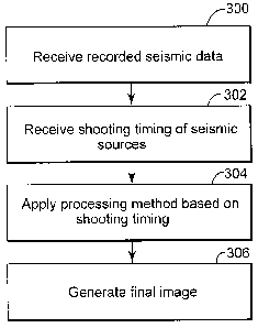
[0022] Figure 3 is a flow chart of a method for determining interference
noise according to an exemplary embodiment;
[0023] Figure 4 illustrates main signals and interference noise recorded
by
seismic sensors of a first seismic survey according to an exemplary
embodiment;
[0024] Figure 5A illustrates seismic data corresponding to a first shot
in the
time-space domain and Figure 5B illustrates the same seismic data in the tau-p
domain;
[0025] Figure 6A illustrates seismic data corresponding to a second shot
in
the time-space domain and Figure 6B illustrates the same seismic data in the
tau-p domain;
[0026] Figure 7A illustrates the seismic data in the tau-p domain and
Figure 7B illustrates the impulsive noise according to an exemplary
embodiment;
[0027] Figure 8 is a flowchart of a method illustrating an iterative
impulsive
denoise mechanism according to an exemplary embodiment;
[0028] Figure 9 is a flowchart of a method for illustrating the iterative
impulsive denoise mechanism performed in plural domains according to an
exemplary embodiment;
7
CA 02827070 2013-09-16
CG200046
[0029] Figure 10 is a flowchart of a method illustrating a joint modeling
mechanism according to an exemplary embodiment;
[0030] Figure 11 is a schematic diagram of a computing device capable to
implement one or more of the methods discussed in the exemplary
embodiments.
DETAILED DESCRIPTION OF THE INVENTION
[0031] The following description of the exemplary embodiments refers to
the
accompanying drawings. The same reference numbers in different drawings
identify the same or similar elements. The following detailed description does
not
limit the invention. Instead, the scope of the invention is defined by the
appended
claims. The following embodiments are discussed, for simplicity, with regard
to the
terminology and structure of a marine seismic system that includes two seismic
sources. However, the embodiments to be discussed next are not limited to a
marine seismic survey or two seismic sources but may be applied to land survey
or
ocean bottom survey, also with a larger number of sources, etc.
[0032] Reference throughout the specification to "one embodiment" or "an
embodiment" means that a particular feature, structure or characteristic
described in connection with an embodiment is included in at least one
embodiment of the subject matter disclosed. Thus, the appearance of the
phrases "in one embodiment" or "in an embodiment" in various places throughout
the specification is not necessarily referring to the same embodiment.
Further,
the particular features, structures or characteristics may be combined in any
suitable manner in one or more embodiments.
[0033] According to an exemplary embodiment, the relative timing of the
interference sources (i.e., at least seismic sources from a first seismic
survey and
seismic sources from a second seismic survey) is not calculated as in the
traditional methods, but rather the actual relative timing is known from the
8
CA 02827070 2013-09-16
CG200046
operators of the seismic surveys. In other words, when both surveys are being
acquired by the same company, or when there is co-operation between
companies operating the vessels of both surveys, it is possible to share the
exact
timing and optionally the location of the seismic sources generating the
interference noise. Thus, rather than calculating the timing of the
interference
noise from the data itself, prior to denoise or as part of the denoising
algorithm,
the timing could be known in advance in a precise manner.
[0034] For effective removal of interference noise, it is preferable to
record
the noise consistently, as will be discussed later. This means that utilizing
continuous recording can be of benefit. This may include recording while the
spread is turning, i.e., the vessel is on the line turn.
[0035] Knowledge of the timing of the interference source can be more
accurate than estimating the timing from the data. It can also simplify
denoise
processes where the noise timing is required. Thus, the novel concepts to be
discussed herein can be applied to any method that removes interference noise
from seismic data where the knowledge of the timing of the source responsible
for the interference noise is known in advance.
[0036] According to an exemplary embodiment illustrated in Figure 2, a
seismic survey system 200 includes at least one vessel 202 that tows a seismic
source 204 and one or more streamers 206. Source 204 may include at least
one airgun, vibratory source, or a combination thereof. The streamer 206
includes plural seismic sensors 208. A seismic sensor may include a geophone,
a hydrophone, an accelerometer, a particle motion sensor, a differential
pressure
sensor, or other sensors designed to receive acoustic or elastic energy, or a
combination of them. For example, a 4C seismic sensor may include a
hydrophone and three accelerometers. Birds 210 may be distributed along the
streamers to achieve desired shapes for them, e.g., curved shapes, straight
lines,
slanted shapes, etc.
9
CA 02827070 2013-09-16
CG200046
[0037] A seismic wave 220a emitted by the source 204 propagates toward
the sea bed 222 and may get reflected. Source 204 may be a marine airgun, a
marine vibrator (towed or stationary), a land dynamite or vibrator, or other
acoustic energy source. The reflected wave 220b may be recorded by seismic
sensor 208a. Of course, the seismic wave 220a may enter the subsurface 224
and get reflected there by an interface and then recorded by a sensor. All
these
elements discussed until now belong to the first seismic survey system 200.
[0038] It is possible that a second seismic survey system 250 takes place
away from the first system 200 but still close enough so that energy generated
by
the seismic source 254 propagates as a wave 270a and after it gets reflected
at
the sea bed 222 (or another interface in the subsurface), the reflected wave
270b
is also recorded by the seismic sensor 208a. This recording corresponding to
the
second seismic vessel 250 produces the interference noise.
[0039] The seismic vessel may also include a control device 230 (e.g.,
processing system) that is capable to receive and process the recorded seismic
data from the seismic sensors. Alternatively, the control device 203 may
provide
minimum processing and the data is transferred to a ground facility for
further
processing.
[0040] Either on the vessel in the control device or at the ground
facility,
the recorded data from the seismic sensors is received in step 300 as
illustrated
in Figure 3. Then, in step 302, the timing when the seismic sources of the
first
and second seismic surveys is received from the operators of the surveys. As
noted above, this time is not calculated or determined from the recorded data
as
in the traditional methods. In step 304, a processing method is applied to the
received seismic data, based on the known (actual) relative shooting timing of
the
seismic sources of the first and second seismic surveys. Assuming for
simplicity,
that the first seismic survey has a single source that is shot at t1 and the
second
seismic survey has a single source that is shot at t2, the actual relative
shooting
CA 02827070 2013-09-16
CG200046
timing is the value of t2-t1. However, this step may use the actual shooting
timing (e.g., the values of t1 and t2 instead of the actual relative shooting
timing.
The processing methods discussed herein are scalable to n seismic survey,
i.e.,
the methods may be applied when more than two seismic surveys are performed
at the same time. In this case, the actual relative shooting timing of the
source of
the first survey and the source of nth survey is necessary to be known. The
processing method removes part or all of the interference noise. The applied
processing method may be any of a number of methods to be discussed next. In
step 306, the final image of the subsurface is generated based on the seismic
data from which the interference noise has been removed.
[0041] The
various processing methods are now discussed in more detail.
A first processing method is one in which the interference noise appears
continuous in the shot domain. For such a basic modeling, if the interference
noise has a different apparent dip compared to the main seismic signal (the
one
coming from the seismic source of the first seismic survey), it can be
filtered.
Many types of modelling can be used for the filtering process, e.g., muting in
the
frequency-wavenumber (FK) domain, the tau-p or Radon domain,
etc. Alternatively, a convolution filter can be designed to attenuate the
energy at
the relevant apparent dip range. The input for this algorithm may be 2D, e.g.,
in
the marine context cable-by-cable, or 3D by using receivers located on more
than
one cable. The model may be derived using a single component, for example
the hydrophone, or to simultaneously satisfy more than one component, for
example hydrophone and at least one particle velocity sensor. Filtering in 3D
may be more accurate, especially when the interference noise comes from the
broadside direction, i.e., travels substantially in a direction perpendicular
to the
streamer. In the marine hydrophone only context, the cable spacing often means
3D transforms are not possible (due to aliasing).
However, where
accelerometers are also available, the extra information from the
accelerometers
may provide dealiasing benefits.
11
CA 02827070 2013-09-16
CG200046
[0042] It is
noted that some shots may not be affected by the interference
noise while others may be only marginally affected. When the timing of the
interference noise is directly known, the interference noise model can be
restricted to the times and offsets that are affected. This would involve
firstly
calculating an interference noise model with any of the existing approaches,
and
then muting the noise model so it may only contain energy at the anticipated
travel times and offsets. In some cases this would mean not requiring a noise
model for shots that are known not to be affected by interference noise. This
approach allows improved parameterisation and more effective noise
attenuation.
[0043] Another
processing method is impulsive denoise. In the shot
domain the interference noise is continuous with offset. However, in other
domains, e.g., receiver domain, common channel domain, common middle point
(cmp) domain, offset volume domain, etc., the interference noise appears
impulsive. The impulsive noise technique can be considered by: 1) noise
flagging followed by 2) noise removal/signal interpolation. Such an algorithm
is
described in Gulunay et al., "Seismic interference noise attenuation," 74th
SEG
international conference meeting, 2004. In this method the noise
removal/signal
interpolation step is comprised of fx reconstruction where affected traces are
reconstructed from surrounding data which is not contaminated by the
interference noise. Steeply
dipping signal can at times be mistaken for
interference noise, so careful parameterization of the method is necessary.
The
application of impulsive denoise can be improved through use of a model space
which may partially distinguish signal and noise, for example based on
apparent
dip. Such a scheme is now illustrated.
[0044] Figure
4 shows interference noise regions 400 and 402 recorded
together with the main seismic data 404 and 406. When data corresponding to a
first shot, see Figure 5A, is transformed in another domain, for example, the
tau-p
domain as illustrated in Figure 5B, the interference noise generated by the
12
CA 02827070 2013-09-16
CG200046
second survey corresponds to 502. In this example the interference noise
largely
occupies a different area of the tau-p space to the signal. For a second shot
as
illustrated in Figure 6A, the interference noise corresponds to 602, which is
at a
different time than the noise 502.
[0045] When the seismic data in the tau-p domain as illustrated in Figure
7A is re-ordered to the constant p-shot domain as illustrated in Figure 7B,
the
interference noise appears random, or impulsive. As there is often already a
separation between signal and noise in this domain, the impulsive denoise
scheme outlined earlier can be applied more effectively.
[0046] When the interference noise is low in amplitude compared to the
signal, it can be difficult to parameterise thresholds to identify the noise,
especially where the signal has high apparent dip. When the timing of the
interference noise is directly known, the interference noise model can be
restricted to times and offsets that are affected. This can allow improved
parameterisation and more effective noise attenuation. The model domain may
be in 2D (e.g., tau-p) or 3D (e.g., tau-px-py).
[0047] Impulsive denoise can be repeated in more than one domain. For
example, the impulsive denoise may be performed in the receiver domain and
the common channel domain independently. This approach provides two
different estimates of noise which can be combined to improve the interference
noise attenuation.
[0048] Another processing method is the iterative impulsive denoise.
When data is sorted in a domain where the interference noise appears
impulsive,
e.g., receiver domain, common channel domain, cmp domain, offset volume
domain, etc., the processes discussed above with regard to the impulsive
denoise may be employed.
13
CA 02827070 2013-09-16
CG200046
[0049] When the interference noise is low in amplitude compared to the
signal, it can be hard to parameterise the algorithm to effectively attenuate
the
noise while at the same time preserve the signal. When this is the case, and
when the timing of the noise is known in advance, it can be advantageous to
align the interference noise. This involves applying a different timeshift for
each
trace in the gather so that the interference noise is aligned. By aligning the
interference noise, the signal appears as impulsive. It can then be possible
to
make a signal model with the same impulsive denoise techniques outline above
when discussing the impulsive denoising.
[0050] After subtracting the signal model from the data, any residual
signal
may once again be aligned (by the reverse of the time shifts applied in the
previous step). Finally, a second pass of impulsive denoise can be used, this
time to attenuate the interference noise. As the data is relatively signal
free at
this point, more harsh parameterisation of denoise can be used.
[0051] The procedure just discussed can be summarized as an iterative
process as follows: in step 800 as shown in Figure 8, sort the recorded
seismic
data to a domain where the interference noise appears impulsive; in step 802
align the interference noise - this is achieved based on the knowledge of the
shooting timing of the sources in the first and second seismic survey and it
is
provided in step 803; in step 804 remove the main signal with impulsive
denoise
attenuation and add the main signal estimate to a signal output dataset; in
step
806 align the main signal; in step 808 remove the interference noise with
impulsive denoise attenuation and add the noise estimate to a noise output
dataset. In step 810, determine if necessary to repeat steps 802 to 808 and
repeat these steps if necessary. The steps may be repeated a constant number
of times based on user tests, or by iterating until a user specified
percentage of
the energy of the input data has been described by the noise and signal
models.
14
CA 02827070 2013-09-16
CG200046
[0052] To obtain the denoised data, in step 812 subtract the interference
noise model made from successive applications of steps 802 to 808 from the
original input data and then generate in step 814 the final image of the
subsurface from the denoised data. The process can be extended to the case
where there is more than one source of interference noise apparent in the data
by aligning the different interference noises one at a time.
[0053] The above procedure requires knowledge of the relative timing of
the noise. This timing can be calculated from the data, or provided up front
with
knowledge of the timing of the interference noise source. Also, knowledge of
the
timing and duration of the noise can be used to restrict the noise model with
each
application of impulsive denoise. The process illustrated in Figure 8 can be
repeated in more than one domain. For example, as illustrated in Figure 9, the
process may be performed in step 900 in the receiver domain and then in step
902 in the common channel domain. These two steps provide two different
estimates of the main signal and the interference noise, which can be combined
in step 904 to improve the interference noise attenuation. Then, based on the
results of step 904, the final image of the subsurface may be generated in
step
906.
[0054] Still another processing method is the joint modelling. This
alternative algorithm derives models of the main signal and interference noise
simultaneously in a single inversion problem. This processing may require that
the seismic data be sorted to a domain where the interference noise is
impulsive
and the relative timing of the interference noise is known either through
calculation from the data or by being provided in advance.
[0055] The seismic data (referred to herein as "seismic data d")
corresponds to the actual data measured by the seismic sensors due to the
firings of the seismic sources. The seismic sources include the one or more
seismic sources of the first seismic survey as well as the one or more seismic
CA 02827070 2013-09-16
CG200046
sources of the second seismic survey (i.e., the interfering seismic surveys).
The
simultaneous or near simultaneous firing of the seismic sources causes
significant energy from all of these firings to be present in the seismic data
vector
d. Models that describe the geology that affects the source energy are
associated with linear operators L that describe the physics of the source
mechanisms, the wave propagation and the survey geometry. The seismic data
vector d may then be characterized as a function of the models and the linear
operators.
[0056] In the general sense, when a linear model m is derived for input
data, the following equation needs to be solved: d = Lm, where d is the input
data
(e.g., a group of traces), m is the model of the data (non-limiting examples
include FK domain, linear Radon, parabolic Radon, hyperbolic Radon), and L is
the linear operator that makes the transition from the model space to the data
space. The above equation may be solved in many ways, e.g., calculating the
inverse of L, conjugate gradients, LU decomposition, Cholesky factorisation,
etc.
[0057] In the case of joint modelling, two models are found
simultaneously;
one for the main signal and one for the interference noise. In this case, the
ms
problem can be outlined as: d = (Ls Dni,n)(,-., ), where D, is a dithering
operator
to introduce the timing of the interference noise, Ls is the linear operator
for the
main signal, Lõ is the linear operator for the interference noise, ms is the
signal
model, and mn is the noise model.
[0058] The linear operators may represent, but are not limited to, the
reverse slant stack or reverse parabolic stack. In one application, the same
linear operator can be used for the main signal and interference noise, i.e.,
Ls =
Ln = L. In another application different linear operators may be used. For
example, the Ls operator may be a reverse parabolic stack, and the Ln operator
may be a reverse slant stack.
16
CA 02827070 2013-09-16
CG200046
[0059] Once a least squares representation of the models have been
found, it is usually necessary to make a new solution with model space
weighting. This can be achieved directly with an 11 norm solver, or by
weighting
the linear transfer matrices based on the result from a previous
iteration. Alternatively, the model weights can be set based on an earlier
estimate of interference noise from the previous processing methods.
[0060] To summarize the joint modelling processing, in step 1000 the data
is sorted to a domain there the interference noise is impulsive. In step 1002,
the
known relative timing of the interference noise is received. In step 1004, two
models ms and mn are simultaneously calculated based on the relative timing of
the interference noise and two operators Ls and L. In step 1006, a new
solution
with model space weighting is performed and in step 1008 the final image of
the
subsurface is calculated.
[0061] It is noted that the above processing methods work best when a
good recording of the main signal and interference noise is achieved. For this
reason, it is preferred to make a continuous recording of the seismic data,
i.e., to
record even during a conventional lag time' of 1 to 2 seconds between trace
recordings or otherwise potential interference noise in the lag time may be
missed.
[0062] The above methods and mechanisms may be implemented in a
computing system specifically configured to calculate the interference noise.
An
example of a representative computing system capable of carrying out
operations
in accordance with the exemplary embodiments is illustrated in Figure 11.
Hardware, firmware, software or a combination thereof may be used to perform
the various steps and operations described herein.
[0063] The exemplary computing system 1700 suitable for performing the
activities described in the exemplary embodiments may include server 1101.
17
CA 02827070 2013-09-16
CG200046
Such a server 1101 may include a central processor (CPU) 1102 coupled to a
random access memory (RAM) 1604 and to a read-only memory (ROM) 1106.
The ROM 1106 may also be other types of storage media to store programs,
such as programmable ROM (PROM), erasable PROM (EPROM), etc. The
processor 1102 may communicate with other internal and external components
through input/output (I/O) circuitry 1108 and bussing 1110, to provide control
signals and the like. The processor 1102 carries out a variety of functions as
is
known in the art, as dictated by software and/or firmware instructions.
[0064] The server 1101 may also include one or more data storage
devices, including a hard drive 1112, CD-ROM drives 1114, and other hardware
capable of reading and/or storing information such as DVD, etc. In one
embodiment, software for carrying out the above discussed steps may be stored
and distributed on a CD-ROM 1616, removable memory device 1118 or other
form of media capable of portably storing information. These storage media may
be inserted into, and read by, devices such as the CD-ROM drive 1614, the disk
drive 1112, etc. The server 1101 may be coupled to a display 1120, which may
be any type of known display or presentation screen, such as LCD displays, LED
displays, plasma display, cathode ray tubes (CRT), etc. A user input interface
1122 is provided, including one or more user interface mechanisms such as a
mouse, keyboard, microphone, touch pad, touch screen, voice-recognition
system, etc.
[0065] The server 1101 may be coupled to other computing devices, such
as the landline and/or wireless terminals via a network. The server may be
part
of a larger network configuration as in a global area network (GAN) such as
the
Internet 1128, which allows ultimate connection to the various landline and/or
mobile client devices. The computing device may be implemented on a vehicle
that performs a land seismic survey.
18
CA 02827070 2013-09-16
CG200046
[0066] The disclosed exemplary embodiments provide a system and a
method for removing or reducing interference noise in seismic data. It should
be
understood that this description is not intended to limit the invention. On
the
contrary, the exemplary embodiments are intended to cover alternatives,
modifications and equivalents, which are included in the spirit and scope of
the
invention as defined by the appended claims. Further, in the detailed
description
of the exemplary embodiments, numerous specific details are set forth in order
to
provide a comprehensive understanding of the claimed invention. However, one
skilled in the art would understand that various embodiments may be practiced
without such specific details.
[0067] Although the features and elements of the present exemplary
embodiments are described in the embodiments in particular combinations, each
feature or element can be used alone without the other features and elements
of
the embodiments or in various combinations with or without other features and
elements disclosed herein.
[0068] This written description uses examples of the subject matter
disclosed to enable any person skilled in the art to practice the same,
including
making and using any devices or systems and performing any incorporated
methods. The patentable scope of the subject matter is defined by the claims,
and
may include other examples that occur to those skilled in the art. Such other
examples are intended to be within the scope of the claims.
19