Note : Les descriptions sont présentées dans la langue officielle dans laquelle elles ont été soumises.
CA 02846359 2014-03-14
Borehole Instrument for Borehole Profiling and Imaging
Cross-reference to Related Applications
[0001] This application claims priority to US provisional patent
application 61/782,767, filed Mar. 14, 2013, and to US non-provisional
patent application 13/826,214, filed Mar. 14, 2013, both of which are
incorporated herein by reference.
Field
[0002] The present invention relates to borehole instruments.
Background
[0003] Existing borehole instruments are limited in the sense that
limited amounts of data can be captured during a single pass of the
instrument within the borehole. Further, such instruments may only be
able to capture data at low rates, which constrains the speed of travel
of the instrument within the borehole and increases the time required to
capture the data.
[0004] When an instrument spends much time within the borehole, it
cannot be serving other boreholes. Thus, the efficiency of geoscience and
engineering projects, such as exploration, geotechnical, hydrogeology,
civil engineering, mining, oil and gas, and pipe inspection projects, is
reduced in waiting for instruments to serve all boreholes. Project cost
and complexity can increase due to an increase in the amount of
instruments needed. In addition, as the time within a borehole increases,
the risk of an instrument becoming physically stuck within the borehole
also increases, and a stuck instrument may have to be abandoned.
[0005] Another problem arises in analyzing different sets of data
captured by different kinds of borehole instruments. Different sets of
data must typically be aligned with each other by highly skilled people.
For instance, visual analysis is performed to adjust different datasets
so that they coincide at all depths. The files containing the datasets
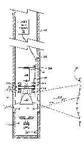
1
CA 02846359 2014-03-14
are then typically merged. This can lead to errors and additional time
before data is ready for geoscience and engineering analysis.
[0006] Furthermore, because running different instruments in the same
borehole adds time to a project, datasets considered nice-to-have but not
essential to a project are often missing because time saving was
paramount and an optional instrument was not run.
[0007] Thus, state-of-the-art borehole instruments may cause geoscience
and engineering projects to be carried out with poor efficiency, and
further may result in gaps in geological knowledge.
Summary
[0008] According to one aspect of the present invention, a borehole
instrument includes a housing sized and shaped to fit inside a borehole,
at least one image sensor disposed within the housing and configured to
capture images of an inside wall of the borehole, at least one
illumination light source disposed within the housing and configured to
illuminate the inside wall of the borehole, at least one laser light
source disposed within the housing and configured to emit laser light
towards the inside wall of the borehole, a data processing subsystem
coupled to the image sensor(s) and configured to receive image data from
the image sensor(s), the image data representative of images of the
inside wall of the borehole. The data processing subsystem is further
configured to capture borehole profile data from images containing laser
light reflected from the inside wall of the borehole.
[0009] According to another aspect of the present invention, a borehole
instrument includes a housing sized and shaped to fit inside a borehole,
a window, at least one image sensor disposed within the housing and
configured to capture images of an inside wall of the borehole through
the window, at least one illumination light source disposed within the
housing and configured to direct illumination light through the window to
the inside wall of the borehole, at least one laser light source disposed
within the housing and configured to emit laser light, laser-shaping
optics configured to shaped emitted laser light into a sheet directed
through the window to the inside wall of the borehole, capturing optics
2
CA 02846359 2014-03-14
positioned to direct image light reflected from the inside wall onto the
image sensor(s) and positioned to direct laser light reflected from the
inside wall onto the image sensor(s), a data processing subsystem coupled
to the image sensor(s) and configured to receive image data from the
image sensor(s), and a computer connected to the data processing
subsystem. The image data is representative of images of the inside wall
of the borehole. The data processing subsystem is further configured to
capture borehole profile data from images containing laser light
reflected from the inside wall of the borehole and to transmit the image
data, the borehole profile data, or both the image data and the borehole
profile data to the computer.
[0010] According to another aspect of the present invention, a method
for capturing data from a borehole includes illuminating an inside wall
of the borehole, emitting laser light onto the inside wall of the
borehole, and capturing images of the inside wall of the borehole. The
captured images are represented by image data. The method further
includes processing the image data to extract borehole profile data from
laser light present in the captured images, and performing the
illuminating, the emitting of laser light, and the capturing of images
during a single pass of the borehole.
Brief Description of the Figures
[0011] FIG. 1 is a schematic diagram of borehole analysis using a
borehole instrument according to an example of the present invention.
[0012] FIG. 2 is a schematic diagram of the borehole instrument.
[0013] FIG. 3 is a functional block diagram of the borehole instrument.
[0014] FIG. 4 is a functional block diagram of a borehole instrument
according to another example.
[0015] FIG. 5 is a schematic diagram of example optical elements of a
borehole instrument.
[0016] FIG. 6 is a block diagram of an example of a processing
subsystem.
3
CA 02846359 2014-03-14
[0017] FIGs. 7a - d are schematic diagrams of example topologies for
power and communications with the borehole instrument.
[0018] FIG. 8 is a schematic diagram of power and communications
through a winch.
[0019] FIG. 9 is a graph illustrating a calibration table.
Detailed Description
[0020] The present invention relates to an in-situ borehole instrument
configured to capture several different datasets from a borehole in as
few passes as possible and as fast as possible, and at higher resolution.
In some examples and under certain dataset requirements and borehole
conditions, only a single pass of the borehole instrument is needed.
Because different datasets can be captured during the same pass, the need
to align different datasets at a later time is reduced or eliminated.
Many of the problems discussed above are solved or have their detrimental
effects reduced.
[0021] The present description adopts the context of geological
analysis in the field of mining and mineral exploration. However, the
borehole instruments, methods, and other techniques described herein may
find other uses and solve problems in other fields, such as pipe
inspection, hydrogeology, oil and gas exploration, engineering, and
scientific study.
[0022] FIG. 1 shows a borehole instrument 10 being used to collect data
from a borehole 12 drilled into a rock formation 14. The instrument 10
may be known as a borehole televiewer. The borehole 12 may be open or
cased. The borehole instrument 10 is connected to the surface by a cable
16 that runs from the borehole instrument 10 to outside the borehole 12,
through a rigging apparatus 18, and to a vehicle 20.
[0023] The cable 16 physically carries the weight of borehole
instrument 10, as well as its own weight, as the borehole instrument 10
is raised and lowered within the borehole 12. To assist in this, the
rigging apparatus 18 may include a pulley supported by one or more
4
CA 02846359 2014-03-14
support arms, which may extend from the vehicle 20 or may be braced
against the ground. At the vehicle 20, the cable 16 can be wrapped around
a drum or winch that is driven to spool the cable 16 in and out.
[0024] The cable 16 can also connect the borehole instrument 10 to the
vehicle 20 for the purposes of signal communications. The cable 16 may
therefore include one or more wire conductors, which may be situated
within a weight-carrying braided steel sheath. The vehicle 20 can include
data acquisition hardware, such as a computer 22 or other device that is
connected to the wire conductors inside the cable 16.
[0025] The vehicle 20 can be a truck, van, or similar. In other
examples, a non-vehicular winch is provided mounted to a portable frame,
which can be configured to be air-dropped to remote regions.
[0026] A depth transducer 24, such an optically encoded wheel in
frictional contact with the cable 16, is connected to the up-hole
computer 22 to measure the depth of the borehole instrument 10 in the
borehole 12 (i.e., with respect to the surface of the ground or some
other reference datum). Depth data 30 can therefore be collected based on
the spooling and unspooling of the cable 16. The depth data 30 can be
compensated for cable stretch and other factors so that an accurate depth
of the borehole instrument 10 can be recorded. The depth data 30 can be
recorded in any increment (e.g., 1 mm, 1 cm, 2 cm, etc.). The depth
transducer may be capable of determining depth with a higher degree of
precision. For illustrative purposes, it is assumed that N samples of
depth data 30 are taken for a particular borehole, so that depths D(1),
D(2)...D(N) are measured and stored at the computer 22.
[0027] The borehole instrument 10 is configured to capture image data
32 of images of the inside wall of the borehole 12. In this example,
images I(1), I(3)... I(N-2), I(N) are captured at regular depths D(1),
D(3)...D(N-2), D(N) and transmitted to outside the borehole 12 via the
cable 16 to be stored in the computer 22. The images captured have a
height (e.g., 2 - 4 cm), so that images need not be captured at each
depth increment and so that sufficient overlap exists to splice images
together. For example, image I(1) is captured at depth D(1), image I(3)
CA 02846359 2014-03-14
is captured at depth D(3), and the height of the captured images means
that no image need be captured at depth D(2) and that images I(1) and
I(3) have sufficient overlap to provide an image at depth D(2) and to
permit splicing of images I(1) and I(3) to produce a continuous image of
a segment of the borehole 12.
[0028] The borehole instrument 10 is also configured to measure the
profile of the inside wall of the borehole 12 to capture profile data 34.
Borehole profiles define the interior dimensions of the borehole and can
include a series of radial measurements, a series of diametrical
measurements, a series of deviations (+/-) from nominal diameter or
radius, or the like. In this example, borehole profiles P(1), P(2)...P(N)
are measured at regular depths D(1), D(2)...D(N) and transmitted to
outside the borehole 12 via the cable 16 to be stored in the computer 22.
[0029] The borehole instrument 10 is also configured to measure its
direction or orientation within the borehole 12 to capture orientation
data 36. Direction data may be measured and stored with respect to a
reference datum, such as magnetic north. In this example, instrument
orientations S(1), S(2)...S(N) are measured at regular depths D(1),
D(2)...D(N) and transmitted to outside the borehole 12 via the cable 16
to be stored in the computer 22. The orientation data 36 can be used to
laterally shift captured images and profile measurements to compensate
for any rotation of the borehole instrument 10 within the borehole 12.
[0030] The borehole instrument 10 performs image capture, profile
measurement, and orientation measurement during the same pass of the
borehole 12. Captured image data 32 and profile data 34 are thus both
measured directly in association with the same depth and orientation
measurements. This means that images and profile measurements are depth-
aligned and of the same orientation without the need for post processing,
which has until now included substantial human effort.
[0031] FIG. 2 shows the borehole instrument 10 in greater detail. The
borehole instrument 10 includes a housing 42 sized and shaped to fit
inside the borehole 12 with clearance. In this example, the housing 42
includes a hollow metal cylindrical tube having closed ends. A
6
CA 02846359 2014-03-14
transparent or semi-transparent window 44 is provided in the housing 42
and is positioned to allow light emitted from inside the housing 42 to
illuminate the inside wall of the borehole 12. In this example, the
window 44 includes a hollow transparent cylinder made of glass or similar
material. The window 44 can be made of abrasion-resistant material and
can have an outside diameter smaller than the outside diameter of the
housing 42 to reduce wear induced by the borehole 12.
[0032] The borehole instrument 10 may further include one or more
centralizers 45 attached to the outside of the housing 42. The
centralizers 45 serve to keep the borehole instrument 10 centered in the
borehole 12. When one centralizer 45 is used, it may be located above or
below the window 44. When two or more centralizers 45 are used, there may
be centralizers 45 located above and below the window 44.
[0033] In some examples, the housing 42 and centralizers 45 are sized
to accommodate boreholes between 75 mm and 300 mm in diameter. For
example, the housing 42 and centralizers 45 are dimensioned to
accommodate a borehole of 75 mm diameter when the centralizers 45 are
near their most-compressed state, and the same housing 42 and
centralizers 45 are further dimensioned to accommodate a borehole of 300
mm diameter when the centralizers 45 are near their most-expanded state.
The same borehole instrument 10 can thus be used in a range of different
borehole sizes.
[0034] The housing 42 is sized and shaped to accommodate borehole
conditions, such as pressure of up to 200 bar (2900 PSI) and temperatures
of up to 50 degrees Celsius. In other examples, the housing 42 can be
configured to withstand other temperatures and pressures.
[0035] The borehole instrument 10 further includes an optical imager
52, a borehole profiler 54, an inertial measurement unit (IMU) 58, and a
data processing subsystem 56 disposed within the interior 46 of the
housing 42. The optical imager 52, borehole profiler 54, and IMU 58 are
each electrically connected to the data processing subsystem 56, which is
connected to the computer 22 via one or more conductive transmission
lines 62, which form part of the cable 16.
7
CA 02846359 2014-03-14
[0036] The cable 16 further includes an electrically insulative inner
sheath 64 that electrically isolates the conductive transmission lines 62
from an outer braided cable sheath 66, which can be made of steel braid
and provides tensile strength to the cable 16.
[0037] Light and other signals emitted from and captured by one or more
of the optical imager 52 and the borehole profiler 54 pass through the
window 44. Data captured about the borehole 12 using the optical imager
52, borehole profiler 54, and IMU 58 are collected by the data processing
subsystem 56 synchronously, so that image data 32, profile data 34, and
orientation data 36 are inherently depth aligned at capture. Power can be
provided to the components 52 - 58 along one or more of the lines 62, and
the outer sheath 66 may be used to provide grounding.
[0038] The data processing subsystem 56 can be configured to process
captured image, profile, and other sensor data, pre-process such data,
communicate such data to an on-board computer (e.g., ref. 160 in FIGs. 7a
- d) or to the up-hole computer 22, store such data, or any combination
of these tasks. Raw captured data that is pre-processed, fully processed,
or communicated to a computer can be stored at the data processing
subsystem 56 for redundancy or can be deleted. When data is stored down-
hole, such as in the data processing subsystem 56 or an on-board
computer, the data processing subsystem 56 can be configured to send
snapshots to the up-hole computer 22 to show the operator that tool is
working properly.
[0039] FIG. 3 shows a functional block diagram of the borehole
instrument 10.
[0040] The optical imager 52 includes one or more illumination light
sources 72 positioned to illuminate an inside wall 82 of the borehole 12
via the window 44. The optical imager 52 further includes one or more
image sensors 74 aligned with the window 44 and positioned to capture
images of the inside wall 82 of the borehole 12. The optical imager 52
may further include a processor, memory, and other hardware to perform
image capture. Imaging light emitted and reflected by the optical imager
52 is shown as dashed lines.
8
CA 02846359 2014-03-14
[0041] The illumination light source 72 can include one or more light-
emitting diodes (LEDs), incandescent bulbs, other kinds of light-emitting
devices, or a combination of such. When the light source 72 includes
multiple discreet elements, these can be positioned to cast a
substantially even field of light into the borehole. The light source 72
can include optics, such as one or more diffusers, mirrors, lenses, or a
combination of such to assist in generating the light field. In other
examples, the light source 72 includes a down-hole end of an optical
fiber (or bundle of such) that runs the length of the cable 16, with the
light emitting element being located at an up-hole end of the optical
fiber (or bundle). Using an optical fiber may help reduce heat generation
and accumulation inside the borehole profiler 54 and thus may prolong its
operating life and extend its operating widow of borehole conditions
(e.g., greater borehole temperatures can be tolerated if the profiler 54
is configured to generate less heat itself).
[0042] The borehole profiler 54 is configured to emit a signal towards
the inside wall 82 of the borehole 12 to measure the profile of the
inside of the borehole 12. In this example, the borehole profiler 54
includes a laser light source 76 aligned with the window 44. Laser light
emitted by the laser light source 76 and reflected from the wall 82 is
shown in dotted line. The laser light source 76 is aligned so that laser
light reflected by the inside wall 82 of the borehole 12 is incident upon
the image sensor 74 of the optical imager 52, which captures profile
measurement signals of the inside wall 82 of the borehole 12 in the form
of images of reflected laser light. One advantage of using the laser
light source 76 is that profiles can be measured in wet, dry, or
partially dry boreholes.
[0043] The laser light source 76 can include a laser-generating device,
such as an 11 mW device having a wavelength of 660 nm, installed within
the housing 42.
[0044] In other examples, the laser light source 76 includes a down-
hole end of an optical fiber (or bundle of such) that runs the length of
the cable 16, with the laser-generating device being located at an up-
9
CA 02846359 2014-03-14
hole end of the optical fiber (or bundle). This may help reduce heat
generation and accumulation inside the borehole profiler 54.
[0045] The image sensor 74 may be a high-speed and high-resolution
charge-coupled device (CCD) or CMOS image sensor, or similar. In this
example, the illumination light source 72 and image sensor 74 are
configured to capture full-color images in, for instance, the RBG color-
space. A set of optics may be provided to direct and focus both the light
of images to be captured and laser light from the profiler 54 into the
image sensor 74. The image sensor 74 may include optical elements (e.g.,
a lens or the like) or may omit such optical elements.
[0046] The illumination light source 72, image sensor 74, and laser
light source 76 are configured to capture data for the full 360 degrees
of the inside of borehole 12.
[0047] In this example, the same image sensor 74 is used to capture
image data 32 and profile data 34. Using a single, shared image sensor
can advantageously reduce the weight, size, and cost of the borehole
instrument 10. Further, this may also reduce the complexity of the data
processing subsystem 56, in that the data processing subsystem 56 may
only be required to transmit one format of data, i.e., data captured by
the image sensor 74.
[0048] The IMU 58 may include a magnetometer with tilt-meters, a
gyroscope, accelerometers, or similar device configured to generate
orientation signals with reference to magnetic north or to the high-side
of the borehole in angled holes. In some examples, the IMU 58 includes a
6-axis gyroscope/accelerometer chip from STMicroelectronics, a tilt
sensor from Murata Manufacturing Co. Ltd., and a compass from
STMicroelectronics.
[0049] As shown, the data processing subsystem 56 is electrically
coupled to the optical imager 52, the borehole profiler 54, and the IMU
58 to receive images, profile measurement signals, and orientation
signals from the optical imager 52, which carries the shared image sensor
74. The data processing subsystem 56 may communicate power level settings
for the illumination light source 72 and the laser light source 76, and
CA 02846359 2014-03-14
may further communicate capture signals indicative of when to capture
images and profile measurements. Capture signals may include depth data
30, which is then encoded with the image data 32, profile data 34, and
orientation data 36 before such is sent up-hole along the lines 62 to the
computer 22.
[0050] The data processing subsystem 56 may use any suitable protocol
for transmitting the captured data 32 - 36 along the lines 62, and such
protocol may depend on the length of the cable 16, the speed of the
borehole instrument, and the amount of data 32 - 36 to be captured, among
other factors. In this example, the protocol is configured to transmit
image data for 360-degree full-color images with 0.5 mm resolution and
profile data also at 0.5 mm resolution at speeds of 6 m/min of the
instrument 10 within the borehole 12 under normal operating conditions.
The protocol may employ data compression and error correction.
[0051] FIG. 4 shows a functional block diagram of a borehole instrument
90 according to another example, in which two image sensors are used. The
instrument 90 is similar to the instrument 10 and for clarity, and only
differences will be described in detail. For other features and aspects
of the instrument 90, the description of the instrument 10 can be
referenced, with like reference numerals identifying like elements.
[0052] The borehole instrument 90 includes a borehole profiler 94
similar to the borehole profiler 54. The borehole profiler 94 includes an
image sensor 96 positioned to capture laser light emitted by the laser
light source 76 and reflected from the inside wall 82 of the borehole 12.
The image sensor 96 thus measures the borehole profile, while the
different image sensor 74 of the optical imager 52 can be dedicated to
capturing images of the borehole wall 82.
[0053] The image sensor 96 may be a high-speed and high-resolution CCD
or CMOS image sensor, or similar. In this example, the image sensor 96 is
configured to capture light of the wavelength band of the laser light
source 76.
[0054] The image sensors 74, 96 may be of the same or different types.
The image sensors 74 and 96 may have different sets of optics.
11
CA 02846359 2014-03-14
[0055] In further examples, additional sensors can be provided to the
borehole instrument 10, such as a temperature sensor, a water sensor (for
detecting leaks into the housing), a current/voltage sensor (to detect
electrical faults), and similar.
[0056] With reference to FIGs. 3 and 4, in other examples, the borehole
profiler 54 is an acoustic device that includes a rotating transducer
that transmits an acoustic pulse into the borehole 12 and measures the
returning amplitude and travel time of the pulse reflected from the
borehole wall 82. Profile data 34 is thus captured by the rotating
transducer. This example is suitable for use in wet boreholes and when
moving parts can be tolerated.
[0057] In view of the above, it should be apparent that the present
invention allows data capture to be performed faster. For example, up
until now a 1000 meter borehole may have required as much as 800 minutes
of scanning time (i.e., 400 minutes each for a profile pass and a
separate imaging pass). With the present invention, a single pass of 400
minutes captures depth-aligned and mutually oriented profile data and
image data, resulting in substantial time saved. Moreover, increased data
capture speed allows for faster movement in the borehole, such that total
capture time may be reduced to less than 200 minutes.
[0058] Further, there can be a reduction in the amount of manual work
and potential for error in manually aligning profile data and image data.
This may also further save time.
[0059] In addition, image and profile data can be acquired with higher
resolution than currently available. For example, existing acoustic
profile technology is limited by a 2 mm acoustic beam diameter, which
means that the typical highest resolution possible is a 2 mm x 2 mm pixel
size or a maximum annular resolution of 288 measurements per 360 degrees.
A 2 mm pixel size is usually not adequate to measure roughness in situ.
When using the laser light source as discussed herein, pixel size can be
as small as 0.5 mm x 0.5 mm, which can result in an annular resolution of
approximately 1000 measurements per 360 degrees.
12
CA 02846359 2014-03-14
[0060] FIG. 5 shows an example of optical elements an example borehole
instrument in accordance with the techniques discussed herein.
[0061] The borehole instrument includes the laser light source 76,
which is selected to emit laser light of about 635 - 680 nm. A multimode
fiber 100 connected the laser light source 76 to a laser output head 102,
which is located at a suitable location inside the housing 42. As
apparent from this example, the laser light source 76 can be located
within the housing 42 or at another location, such as up-hole with the
fiber 100 extending the length of the cable 16 (FIG. 2).
[0062] A camera board 104 having the image sensor 74 is fixed inside
the housing 42. A pinhole objective lens 106 or other optical element can
be positioned ahead of the image sensor 74. The image sensor 74 is used
to capture both borehole images and profile measurements, as discussed
above with respect to FIG. 3.
[0063] The borehole instrument further includes the illumination light
source 72, which in this example includes a plurality of white LEDs 108
and reflectors 110 arranged to cast illumination light out of the housing
and through the window 44. In this example, 50 - 100 LEDs are used and
are operated in pulse mode with 3 - 5 times over-current (using pulse
mode).
[0064] The window 44 in this example is in the shape of a hollow
cylinder and is made of fused silica. In other examples, flat panes of
material can be arranged in a polygonal shape, such as an octagon or the
like. In this example, the fused silica cylindrical window 44 under 200
bar pressure requires a 6.5 mm thickness for the window 44. Hence, when
the outside diameter of the housing is selected to be 45 mm to
accommodate 75 mm diameter boreholes, then the housing's inside diameter
for fitting of the internal components is 32 mm.
[0065] The borehole instrument further includes capturing optics for
directing light entering the window 44 towards the image sensor 74. In
this example, the capturing optics is an imaging mirror 112. The imaging
mirror 112 is aspheric in shape and is positioned to face the pinhole
objective lens 106 so as to concentrate light incoming through the window
13
CA 02846359 2014-03-14
44 onto the pinhole objective lens 106 for capture by the image sensor
74. In other examples, a lens, such as a wide-angle or fisheye lens is
used as the capturing optics instead of the imaging mirror. In still
other examples, multiple mirrors, multiple lenses, or combinations of one
or more mirrors and one or more lenses can be used as the capturing
optics.
[0066] In other examples, multiple image sensors 74 are positioned to
directly face the window 44 and arranged in a circular pattern to capture
360 degrees of the borehole wall 82 with overlap for image combining. In
such examples, capturing optics may not be required.
[0067] The borehole instrument further includes laser-shaping optics
114 positioned in the path of the laser and configured to shape the laser
for projection onto the borehole wall 82. The laser-shaping optics 114
can include reflectors, lenses, beam expanders, and the like. In this
example, the laser-shaping optics 114 are configured to shape the laser
into a frustoconical sheet 116 of laser light (dashed line) that projects
onto the borehole wall 82 as a ring, which is captured by the image
sensor 73 for the borehole profile measurement.
[0068] The laser-shaping optics 114 can be configured to direct the
laser light towards the 82 at an angle A with respect to the general or
average direction 118 of incoming light from the field of view (dotted
lines) for capture by the image sensor 74. The angle A affects the
sensitivity of the borehole profile measurement, and can be selected to
provide a desired sensitively without being overly sensitive so as to
cause the laser ring to leave the field of view of the image sensor 74.
Examples of suitable angles and ranges of angles for angle A include 10 -
30 degrees, 10 - 20 degrees, and about 15 degrees.
[0069] In other examples, The laser-shaping optics 114 can be
configured to cast patterns different from a single ring, such as two or
more rings at different positions and/or different angles A or a grid or
mesh pattern.
[0070] The image sensor 74 can be a CMOSIS CMV2000 image sensor having
a 1088 x 2048 pixel resolution with a color Bayer pattern, and operable
14
CA 02846359 2014-03-14
at 340 full frames/sec. The resolution at a working distance of 90 mm is
about 56 um/pixel and the resolution at a working distance of 250 mm is
about 158 um/pixel. The resolution at a working distance of 250 mm with
angle A of 15 degrees is about 500 um/pixel. When the borehole instrument
is moved at a rate of about 6 m/min, the image sensor capture rate allows
for a 28.5 mm high image of a wall of a 75 mm borehole with about 50%
overlap between images and at least 40 profile measurement captures per
borehole image captured. The resolution allows for at least a 0.5 mm
horizontal (circumferential) resolution for a 300 mm borehole. The
exposure time can be set to about 2.86 msec for a vertical resolution
better than about 0.5 mm at 6 m/min instrument speed.
[0071] FIG. 6 shows a block diagram of an example of the processing
subsystem 56.
[0072] The processing subsystem 56 is connected to the image sensor 74,
the IMU 58, and a computer, such as the up-hole computer 22 or a computer
onboard the borehole instrument.
[0073] The processing subsystem 56 includes a laser controller 130
coupled to or forming part of the laser light source 76 and an
illumination controller 132 coupled to or forming part of the
illumination light source 72. The processing subsystem 56 further
includes a microcontroller 134, a data acquisition controller 136, a data
processor 138, a communications interface 140, and two buffers 142, 144.
[0074] The laser controller 130 is connected to the data acquisition
controller 136 and is configured to drive and modulate the laser light
source 76 according to commands from the data acquisition controller 136.
That is, when the data acquisition controller 136 is to capture a profile
measurement, the data acquisition controller 136 can control the laser
controller 130 to turn on the laser light source 76. Conversely, when the
data acquisition controller 136 is to capture an image of the borehole
without the laser ring, then the data acquisition controller 136 can
control the laser controller 130 to turn off the laser light source 76.
[0075] The illumination controller 130 is connected to the data
acquisition controller 136 and is configured to drive and modulate the
CA 02846359 2014-03-14
illumination light source 72 according to commands from the data
acquisition controller 136. When the data acquisition controller 136 is
to capture an image of the borehole wall, the data acquisition controller
136 can control the illumination controller 130 to turn on the
illumination light source 72. Conversely, when the data acquisition
controller 136 is to capture a laser profile measurement, then the data
acquisition controller 136 can control the illumination controller 130 to
turn off the illumination light source 72.
[0076] The microcontroller 134 communicates with the computer via the
communications interface 140. Such communications may be routed through
an intermediate interface 146 that is coupled between the data processor
138 and the communications interface 140. The microcontroller 134 is
connected to data acquisition controller 136 and data processor 138 and
controls such based on commands received via the communications interface
140. The microcontroller 134 is also connected to the IMU 58 and receives
data from the IMU 58 and forwards such to the data acquisition controller
136. The microcontroller 134 can be programmed to control the overall
operations of the processing subsystem 56, such as changing the
amounts/ratios of images and profile measurements captured, the intensity
and timing of illumination and laser light, and image sensor 74 operating
parameters such as gain. In this example, the microcontroller 134 is an
ARM Cortex M4 microcontroller or similar device.
[0077] The data acquisition controller 136 controls image capture from
the image sensor 74 and receives borehole wall images and laser profile
images. The data acquisition controller 136 can be configured with
capture rates and other capture parameters. The data acquisition
controller 136 can provide clock signal for the image sensor 74 and read
in real-time pixel values (e.g., 16 pixels in parallel). The data
acquisition controller 136 is selectably connected to the buffers 142,
144 and sends read pixel data to the selected buffer 142, 144. The data
acquisition controller 136 can also provide control signals to the
illumination controller 132 and the laser controller 130.
[0078] The data processor 138 is selectably connected to the buffers
142, 144 and receives pixel data from the selected buffer 142, 144.
16
CA 02846359 2014-03-14
[0079] The data processor 138 can be configured to perform various
amounts of processing. In one example, the data processor 138 performs
all borehole image processing and borehole profile measurement, as well
as directional data processing, and sends resulting data to the
communications interface 140, via the intermediate interface 146, for
storage in the borehole instrument and/or communication to the up-hole
computer 22.
[0080] In another example, the data processor 138 performs pre-
processing on some or all of the captured borehole image data, borehole
profile measurements, and captured directional data. The data processor
138 then sends pre-processed data to the communications interface 140,
via the intermediate interface 146, for storage in the borehole
instrument, further processing by an onboard computer, and/or
communication to the up-hole computer 22.
[0081] If data is stored in memory in the borehole instrument, it can
be retrieved when the borehole instrument is removed from the borehole.
[0082] In the current example, the data processor 138 performs pre-
processing by finding laser pixels in images that contain the laser ring
and determining a center-of-gravity of the laser ring. This compensates
for any lateral movement of instrument in the borehole and any changes in
profile of the borehole, which is useful when processing the borehole
wall images. In another example, the pre-processing by data processor 138
is limited to finding and isolating laser pixels in images that contain
the laser ring for later center-of-gravity determination by a computer.
[0083] The data processor 138 can further be configured to compress
borehole images, including those with or without laser rings, before
sending such to the communications interface 140. Such compression can be
lossless (e.g., PNG) or lossy (e.g., JPEG, MPEG).
[0084] The data processor 138 can further be configured to align
captured borehole images with the relevant profile measurements and with
position/yaw/pitch/tilt/direction data from the IMU 58, as well as data
from any additional sensors. The data processor 138 can further timestamp
captured data before sending such to communications interface 140.
17
CA 02846359 2014-03-14
[0085] The buffers 142, 144 are switched so as to allow the data
acquisition controller 136 to fill one buffer while the data processor
reads the other. In this example, the buffers 142, 144 include dual-port
SRAM configured in dual-buffer fashion.
[0086] The communications interface 140 is configured to provide two-
way communications between the processing subsystem 56 and a computer,
such as the up-hole computer 22 or a computer on board the instrument.
The communications interface 140 can include a high-speed USB interface,
an Ethernet interface, or the like.
[0087] In this example, the data acquisition controller 136, data
processor 138, and intermediate interface 146 are provided on a field-
programmable gate array (FPGA) 150, such as the Spartan-6 FPGA from
Xilinx, Inc. A co-processor, such as the STM32F407 MCU from
STMicroelectronics, may also be provided to support the FPGA and increase
efficiency.
[0088] FIGs. 7a - d show example topologies for power and
communications with the borehole instrument.
[0089] In FIG. 7a, the up-hole computer 22 communicates with a computer
160 on board the borehole instrument. The on-board computer 160 is
connected to the processing subsystem 56, which directly controls data
acquisition. The on-board computer 160 receives raw or pre-processed data
from the processing subsystem 56 and further processes it for
communication to the up-hole computer 22, which can be supplied with
memory sufficient for long-term storage or captured and processed data.
The communications link 162 between the computers 22, 160 is selected for
suitable performance over expected operational depths of the borehole
instrument, such as hundreds of meters. In one example, the
communications link 162 is an Ethernet link. Power-over-Ethernet (PoE)
may also be used to supply power to the on-board computer, the processing
subsystem 56, and other components of the borehole instrument. The
shorter communications link 164 between the on-board computer 160 and the
processing subsystem 56 can be selected to be a USB link or similar.
18
CA 02846359 2014-03-14
[0090] In FIG. 7b, the up-hole computer 22 communicates directly with
the processing subsystem 56. The up-hole computer 22 receives raw or pre-
processed data from the processing subsystem 56 and further processes it
for long-term storage in suitable memory, or simply stores raw or pre-
processed data for off-site processing. The communications link 162
between the computer 22 and the processing subsystem 56 can be an
Ethernet link or similar, and accordingly the processing subsystem 56 can
be provided with an Ethernet interface. Power-over-Ethernet may also be
used to supply power to the processing subsystem 56 and other components
of the borehole instrument.
[0091] In FIG. 7c, the up-hole computer 22 is omitted and only a power
source 166 is provided at the up-hole end. The on-board computer 160
receives raw or pre-processed data from the processing subsystem 56 and
further processes it for long-term storage in suitable memory, or simply
stores raw or pre-processed data for off-site processing. Power lines 168
are provided between the power source 166 and the on-board computer 160,
the processing subsystem 56, and other components of the borehole
instrument. The communications link 164 between the on-board computer 160
and the processing subsystem 56 can be selected to be a USE link or
similar.
[0092] In FIG. 7d, the computers 22, 160 are omitted and only a power
source 166 is provided at the up-hole end. The processing subsystem 56
has sufficient memory for long-term storage of raw or pre-processed data.
Power lines 168 are provided between the power source 166 and the
processing subsystem 56 and other components of the borehole instrument.
[0093] Computers suitable for use as the computers 22, 160 include
computers having an ARM Cortex A8 AM335x processor from Texas Instruments
running Linux, high speed USB2 ports, DDR3 memory interface for 16-bit
256MB memory, Ethernet 1000-baseT ports, and a Micro-SD card interface.
Each computer 22, 160 may further include a VDSL-2 modem, such as the
MT2301 chipset available from Metanoia Communications Inc. of Taiwan that
allows compact Ethernet-to-Ethernet connection over twisted pair.
19
CA 02846359 2014-03-14
[0094] With reference to FIG. 7a, in one example, the on-board computer
160 is configured to obtain image and profile data from the data
processor 138 (FIG. 6) via the communications interface 140, store such
data in DDR memory, compress borehole wall images (to lossless PNG,
lossless/lossy JPEG, etc.), run a client side of a network, send frames
upstream to the up-hole computer 22 (which operates as a server) through
the Ethernet link 162 using the VDSL-2 modem, and receive and decode
commands from the up-hole computer 22 and send such to the
microcontroller 134 of the processing subsystem 56.
[0095] The up-hole computer 22 is configured to receive data through
the Ethernet link 162 using the VDSL-2 modem, decompress received images,
unwrap borehole wall images into the cylindrical shape of the borehole,
build the 3D representation of the borehole surface using 3D
triangulation data and OpenGL, stitch borehole images together using data
from the IMU 58 and/or data from the depth transducer 24 and/or graphical
image stitching techniques, and display and store the assembled 3D
representation of the borehole.
[0096] FIG. 8 shows an example of how power and communications can be
transmitted across a winch 180 between the up-hole computer 22 and the
borehole instrument, with reference to the example topology of FIG. 7a.
[0097] One or more power lines 182 from the up-hole computer 22 (or a
separate power source) are routed through the slip rings 184 of the winch
180. A wireless link 186, such as a WIFI link, is provided between the
up-hole computer 22 and a wireless device 188, such as a modem or router,
that is wire-connected to the top of the cable and mounted to the
rotating part of the winch 180. This can avoid electrical noise from the
slip rings 184 from entering the communications link.
[0098] With reference to FIG. 9, borehole wall images can be processed
by triangulation using pre-calculated 3D conversion tables. A calibration
process can be performed to construct these tables before the instrument
is deployed. Conversion tables can be stored and applied in any of the
processing subsystem 56 and the computers 22, 160.
CA 02846359 2014-03-14
[0099] Round-shaped borehole images result from the optical arrangement
shown in FIG. 5. In other optical arrangements, different shaped images
may result and these may also require calibration tables. Conversion
tables allow such images to be unwrapped and represented as rectangular
(unrolled cylindrical) images or cylindrical 3D images. FIG. 9 shows the
logic behind example conversion tables for round-shaped images. The R-
axis represents the radius of the round-shaped image in pixels, the 0-
axis represents the angle in increments. Output for triangulation (D)
shows a distance coordinate, i.e., a radius distance to the surface of
the wall. The output for unwrapping (H) shows a vertical coordinate of
the pixel in the unwrapped image.
[00100] While the foregoing provides certain non-limiting example
embodiments, it should be understood that combinations, subsets, and
variations of the foregoing are contemplated. The monopoly sought is
defined by the claims.
21