Note : Les descriptions sont présentées dans la langue officielle dans laquelle elles ont été soumises.
CA 02854666 2016-01-11
PCT PATENT APPLICATION
METHODS FOR GE. STEERING A DRILL BIT IN
REAL TIME USING DRILLING ACOUSTIC SIGNALS
BACKGROUND
Field of the Invention:
100011 Embodiments of the invention generally relate to hydrocarbon
production, and
more particularly, to drilling operations using well loping and measurement
techniques for
steering a drill bit within a pay zone in a lateral vell using acoustic
signals generated by the
drill bit drilling into rock.
Description of the Related Art:
100021 To increase oil or gas production of a well, an effective approach
is to drill the well
with a substantially lateral trajectory (e.g., a horizontal or lateral well)
in a petroleum
reservoir to increase the drainage area in the reservoir. It is therefore
desired to maintain the
drill bit within the targeted reservoir formation or pay zone during the
horizontal or lateral
drilling.
10003j If the pay zone's geometry and distribution in space is precisely
known, it will be
easy to maintain the drill bit within the pay zone during lateral drilling.
However, this is
rarely the case. Geometry and distribution information of a pay zone before
drilling, normally
derived from seismic survey, offset wells, and local geological information,
has significant
error. Therefore, it can be extremely difficult to achieve good contact (i.e.,
high portion of a
lateral section within a pay zone) if only the predefined geometry and
distribution
information of the pay zone is used to steer the drill bit through the pay
zone in the lateral
well, especially when the pay zone is thin.
R)004] To achieve better contact within the pay zone, geosteering can be
employed.
Traditionally, geosteering has been used to determine the position of the
drill bit or drill
string relative to the boundary between the pay zone and the surrounding rocks
(e.g.,
overlying, underlying, and lateral layers) during drilling. The relative
position of the drill bill
-1
CA 02854666 2014-05-05
WO 2013/074745
PCT/US2012/065211
is used to steer the drill bit within the pay zone, producing a lateral
section having a
maximum contact within the pay zone of the lateral well.
100051 For
example, measuring rock properties during drilling can provide the operator
the ability to steer a drill bit in the direction of desired hydrocarbon
concentrations. These
types of systems typically utilize acoustic sensors located inside or adjacent
to the drilling
string to transmit acoustics associated with the drill bit encountering
downhole rock
formations (e.g., overlying, underlying, and lateral layers). Acoustic sensor
data can be
relayed to a measurement-while-drilling (MWD) or logging-while-drilling (LWD)
tool,
which either relays data via a wireline running inside the drilling string to
the MWD/LWD
tool at the surface, or through a borehole acoustic telemetry system which
translates an
acoustic signal through the drilling string or through the adjacent formation
layers. Each
methodology has its own set of disadvantages.
100061 The
wireline technique, although providing an arguably higher data rate, requires
a
wireline connected to the MWD/LWD tool, which must be deployed with the
MWD/LWD
tool. The acoustic telemetry methodology, albeit arguably the cheapest to
implement, has a
limited data rate, and thus, cannot support the transmission of raw data,
requiring some form
of lossy data reduction.
100071 Many of the conventional MWD/LWD geosteering tools, some of which are
configured to have a bit rate capability that can be sufficient to allow for
the provision of raw
data, only provide data describing encountered rock used in steering the drill
bit that is behind
the drill bit. As shown in FIG. 1, for example, the measurement sensor 101 of
the
conventional geosteering system is positioned a few dozen feet (e.g., 30 to 50
feet) behind the
drill bit 102. Therefore, location of the boundary between the pay zone 103
and the overlying
rock 104 (i.e., upper boundary), and the boundary between the pay zone 103 and
underlying
rock 105 (i.e., lower boundary), are determined at the measurement sensor's
101 position
behind the drill bit 102. The drill bit 102 is steered or maintained within
the pay zone 103 by
keeping the drill string 106, at the sensor position 101, in the middle, or
certain position
between the upper and lower boundaries 104, 105, of the pay zone 103. Because
the
measurement sensor 101 is positioned behind the drill bit 102, conventional
geosteering
systems, as shown in FIG. 1, are unable to immediately notify an operator that
the drill bit
102 has already left the pay zone 103. Therefore, these tools are not real-
time tools.
-2-
CA 02854666 2014-05-05
WO 2013/074745
PCT/US2012/065211
100081 In other
conventional geosteering systems, drilling tools use either resistivity or
sonic measurement to guide the drill bit during horizontal or lateral
drilling. When resistivity
measurements are employed, the upper and lower boundaries are computed from
geological
models using inversion techniques. A geological model can include predefined
surrounding
layers, predefined resistivity of the pay zone and the surrounding layers, and
assumed
thickness of the pay zone and the surrounding layers. In the inversion
calculation, predicted
tool response can be computed from a predefined geological model. The
difference between
the predicted tool response and the measured one can be calculated. If the
difference is less
than a preselected threshold, the assumed thicknesses of the pay zone and
surrounding layers
are treated as the "right" ones and the upper and lower boundaries are thus
derived.
Therefore, in this process, different combinations of layer thicknesses are
searched until a
right set is found. As rooted in the inversion techniques, the solution is not
unique (i.e.,
different combinations of the thickness of pay zone and surrounding layers
with different
resistivity can result in the same or similar resistivity patterns). Thus, for
the same measured
resistivity pattern, different upper and lower boundaries can be determined.
100091 When sonic measurements are employed, the upper and lower boundaries
can be
calculated from the travelling time of the reflected sonic waves and sonic
velocity of the
formation rocks. Sonic velocities of the formation rocks can be measured in
situ or
determined prior to drilling.
100101
Therefore, the aforementioned conventional geosteering systems are limited in
that
the formation used to steer the drill bit is derived at the location of the
measurement sensor a
few dozen feet behind the drill bit. Therefore, it is possible that although
the position of the
measurement sensor is in the pay zone, the drill bit may be drilling out of
the pay zone.
When it is determined that the drill bit is following the incorrect path at
the measurement
sensor location, a certain significant length of lateral section may have
already been drilled
out of the pay zone. When this happens, it may require a significant distance
to adjust the
drill bit back into the pay zone, resulting in a lateral section of the well
with some non-
productive fractions and thus reducing productivity of hydrocarbon production.
As previously
described, conventional geosteering systems are also limited by the use of
resistivity
techniques producing non-unique solutions, thereby reducing productivity of
hydrocarbon
production.
100111 Some
newer types of geosteering systems utilize a dedicated electronics unit and a
segmented broadband cable protected by a reinforced steel cable positioned
within the drill
-3-
CA 02854666 2014-05-05
WO 2013/074745
PCT/US2012/065211
pipe to provide a faster communication capability. Such geosteering systems
have been
employed into conventional LWD tools to enhance the resolution of the logged
information.
However, such geosteering systems require the provision of a segmented cable,
whereby each
segment connects to an inductive coil at the end of each separate drill pipe,
which must
survive the forces and environment encountered when connecting/running the
drill pipe
segments.
100121 Other
newer types of geosteering systems attempt to provide data for steering the
drill bit, at least near-real-time, while still utilizing conventional
borehole telemetry systems
(i.e., having a relatively slow bit rate). These geosteering systems can
include, for example, a
dowrthole processor configured to provide dowrthole on-site processing of
acoustic data to
interpret the lithographic properties of the rock encountered by the drill bit
through
comparison of the acoustic energy generated by the drill bit during drilling
with
predetermined bit characteristics generated by rotating the drill bit in
contact with a known
rock type. The lithographic properties interpreted via the comparison are then
transmitted to
the surface via the conventional borehole telemetry system. Although providing
data in a
reduced form requiring only a bit rate speed, these conventional geosteering
systems fail to
provide raw data real-time which can be used for further analysis. It is
nearly impossible to
construct additional interpretation models or modify any interpretation models
generated by
this type of downhole processor.Further, they require additional and
potentially expensive
hardware that must be positioned between the drill bit and the drill.
100131 In order
to improve the contact of the drill bit through the pay zone of the lateral
well while drilling, and thus, the productivity of hydrocarbon production
processes, an
apparatus, computer program product, and a method are needed for steering the
drill bit
through the pay zone in real-time. Furthermore, methods are needed that
include
employing/installing an apparatus having acoustic sensors positioned adjacent
to the drill bit
(i.e., near the front of the drill bit) to detect drill sounds during drilling
operations, a
dovvnhole computer/processor positioned to receive raw acoustic sensor data
and to process
the raw acoustic sensor data to determine acoustic characteristics of the
drilled rock, a
telemetry system for pushing acoustic feature data to a surface computer and a
computer/processor positioned to receive the acoustic characteristics data to
derive the rock
type, to evaluate the properties of the rock (e.g., lithology type and other
petrophysical
properties, as non-limiting examples), and to generate instructions for
steering the drill bit
through the pay zone in real-time based on the derived rock type and
properties.
-4-
CA 02854666 2014-05-05
WO 2013/074745
PCT/US2012/065211
SUMMARY
100141
Embodiments of the invention are directed to an apparatus, computer program
product, and method for steering a drill bit through a vertical and lateral
pay zone in real-time
for well production in the oil and gas industry. In particular, in accordance
with an
embodiment of the invention, there is provided an apparatus for steering a
drill bit within a
pay zone in a lateral well. The apparatus includes a drill bit configured to
drill through an
encountered rock in the lateral well, and a sensor arranged adjacent to the
drill bit and
configured to receive real-time acoustic signature data indicating acoustic
signatures of the
rock being encountered by the drill bit. The apparatus further includes a
processor configured
to compare the received real-time acoustic signature data indicating acoustic
signatures of the
rock being encountered by the drill bit to predetermined acoustic signatures
determined for a
plurality of rock samples. The processor is further configured to identify a
lithology type of
the rock being encountered by the drill bit based on the comparison, and steer
the drill bit in a
predefined direction, in real-time, based on the identified lithology type of
the rock, for
maintaining the drill bit within the pay zone of the lateral well.
100151 In
accordance with another embodiment of the invention, there is provided a
method for steering a drill bit within a pay zone in a lateral well. The
method includes
receiving acoustic signature data from a downhole processor assembly. The
acoustic
signature data includes an amplitude spectrum and one or more acoustic
characteristics
evaluated from an acoustic signal provided by a sensor arranged adjacent to a
drill bit and
generated in real-time as a result of rotational contact of the drill bit with
encountered rock in
the lateral well during drilling. The method further includes comparing the
received real-time
acoustic signature data to predetermined acoustic signatures determined for a
plurality of rock
samples, and identifying a lithology type of the rock being encountered by the
drill bit based
on the comparison. Further, the method includes steering the drill bit in a
predefined
direction, in real-time, based on the identified lithology type of the rock,
for maintaining the
drill bit within the pay zone of the lateral well.
100161 In
accordance with another embodiment of the invention, there is provided a
computer program product embodied on a computer readable storage medium. The
computer
program product is configured to control a processor to perform a process. The
process
includes receiving acoustic signature data from a downhole processor assembly.
The acoustic
signature data includes an amplitude spectrum and one or more acoustic
characteristics
evaluated from an acoustic signal provided by a sensor arranged adjacent to a
drill bit and
-5-
CA 02854666 2014-05-05
WO 2013/074745
PCT/US2012/065211
generated in real-time as a result of rotational contact of the drill bit with
encountered rock in
the lateral well during drilling. The process further includes comparing the
received real-time
acoustic signature data to predetermined acoustic signatures determined for a
plurality of rock
samples, and identifying a lithology type of the rock being encountered by the
drill bit based
on the comparison. Further, the process includes steering the drill bit in a
predefined
direction, in real-time, based on the identified lithology type of the rock,
for maintaining the
drill bit within the pay zone of the lateral well.
BRIEF DESCRIPTION OF DRAWINGS
100171 So that the manner in which the features and advantages of the
invention, as well
as others which will become apparent, may be understood in more detail, a more
particular
description of th.e invention briefly summarized above may be had by reference
to the
embodiments thereof which are illustrated in the appended drawings, which form
a part of
this specification. It is to be noted, however, that the drawings illustrate
only various
embodiments of the invention and are therefore not to be considered limiting
of the
invention's scope as it may include other effective embodiments as well.
100181 FIG. 1 is a schematic diagram of a conventional geosteering system
having sensors
positioned a few dozen feet behind a drill bit.
100191 FIG. 2
is a schematic diagram of a geosteering system for steering a drill bit within
a pay zone using acoustic signals generated by the drill bit drilling into
rock, in accordance
with an embodiment of the invention.
100201 FIG. 3
is a partial schematic and partial perspective view of the geosteering system,
as shown in FIG. 2, for steering a drill bit within a lateral pay zone using
acoustic signals
generated by the drill bit drilling into rock, in accordance with an
embodiment of the
invention.
100211 FIG. 4
is a set of graphs illustrating the amplitude spectrums of a cap rock, a pay
zone, and a bed rock, respectively, of a rock being drilled by a drill bit, in
accordance with an
embodiment of the invention.
100221 FIGS. 5(a) and (h) are flow diagrams of a method performed by the
geosteering
system, as shown in FIGS. 2 and 3, for up-down steering a drill bit through a
lateral pay zone,
in accordance with an embodiment of the invention.
-6-
CA 02854666 2014-05-05
WO 2013/074745
PCT/US2012/065211
100231 FIG. 6
is a cross sectional area of a lateral pay zone having a strong lithology
contrast at an upper boundary and a gradual lithology change downward in a
transitional
zone, in accordance with an embodiment of the invention.
100241 FIG. 7 is a perspective diagram of a path taken by a drill bit through
a channel pay
zone using acoustic signals generated by the drill bit drilling into rock, in
accordance with an
embodiment of the invention.
100251 FIGS. 8(a)-(c) are flow diagrams of a method performed by the
geosteering
system, as shown in FIG. 2, for left-right steering a drill bit through a
channel pay zone, in
accordance with an embodiment of the invention.
100261 FIG. 9 is a cross sectional area of a channel pay zone having a
material in a channel
which gradually becomes muddy toward the banks of the channel, in accordance
with an
embodiment of the invention.
100271 FIG. 10 is a diagram of predefined, preliminary and actual bank
boundaries of a
channel, in accordance with an embodiment of the invention.
DETAILED DESCRIPTION
100281 The present invention will now be described more fully hereinafter with
reference
to the accompanying drawings, which illustrate embodiments of the invention.
This invention
may, however, be embodied in many different forms and should not be construed
as limited
to the illustrated embodiments set forth herein. Rather, these embodiments are
provided so
that this disclosure will be thorough and complete, and will fully convey the
scope of the
invention to those skilled in the art. Like numbers refer to like elements
throughout. Prime
notation, if used, indicates similar elements in alternative embodiments.
100291
Generally, embodiments of the invention are directed to drill bit acoustic
logging
tools for vertically and laterally steering a drill bit. In particular, the
tools employed use drill
bit sounds (i.e., hereinafter referred to as "drilling acoustic signals")
generated by the drill bit
drilling into rock to derive acoustic properties, lithology or rock types, and
rock physical
properties (e.g., porosity, fracture density, water saturation, permeability,
and hydrocarbon
presence) (i.e., hereinafter collectively referred to as "petrophysical
properties") to steer the
drill bit in real time. The petrophysical properties derived from the drilling
acoustic signals
for the pay zone and the surrounding rocks may be first obtained from a
vertical section of
the well under drilling or from offset wells.
-7-
CA 02854666 2014-05-05
WO 2013/074745
PCT/US2012/065211
100301 When
drilling into different rock lithologies or the same rock lithology with
different properties (e.g., porosity, water saturation, permeability, presence
of fractures, etc.),
the generated drilling acoustic signals emanating from the drill bit are
distinctly different.
According to various embodiments of the invention, the drilling acoustic
signals are
transmitted upward along a drill string. A downhole sensor subassembly
containing acoustic
sensors is positioned above the drill bit and connected to the drill string.
The drill bit
transmits the drilling acoustic signals to a downhole sensor subassembly and
are picked up by
the acoustic sensors. The drilling acoustic signals received by the acoustic
sensors (i.e.,
generally after amplification) can be transmitted to a processor/processor
assembly
(hereinafter referred to as "processor") which can generate Fast Fourier
Transformation
(FFT) data (i.e., amplitude spectrums) by transforming the drilling acoustic
signals using a
FFT. The processor can use the amplitude spectrums to further evaluate
additional acoustic
characteristics (e.g., mean frequency, normalized deviation of the frequency,
mean amplitude,
etc.) of the drilling acoustic signals. The amplitude spectrums and the
additional acoustic
characteristics of the drilling acoustic signals will be collectively referred
to as "acoustic
signatures" hereinafter. According to certain embodiments of the invention,
the acoustic
signature of the each rock formation can be transmitted to the surface using a
borehole
telemetry system, which can include various components such as, for example, a
downhole
data inteiface, an electrical/acoustic/wireless medium, a surface data
interface, eic. On the
surface, the lithology type and petrophysical properties of the rock under
drilling can be
derived from the acoustic signature to horizontally and laterally steer the
drill bit through the
pay zone in the lateral well in real time.
100311
According to certain embodiments of the invention, the drill bit is kept in,
or
steered within, the pay zone by continuously comparing the observed acoustic
signatures
under drilling, in real time, against known acoustic signatures of the pay
zone and the
surrounding rocks, as shown, for example, in FIG. 4, as will be described in
more detail
below. Since the acoustic signature of the pay zone is different from the
acoustic signatures
of the surrounding rocks, the driller will be able to instantaneously adjust
the drilling
direction of the drill bit when the drill bit drills out of the pay zone,
allowing the driller to
drill smoother lateral or horizontal wells with better contact with the
production zone,
detection of formation boundaries, and detection of fractured zones, which can
advantageously result in better hydrocarbon productivity within the well.
-8-
CA 02854666 2014-05-05
WO 2013/074745
PCT/US2012/065211
100321 According to various embodiments of the invention, the acoustic
signatures of the
pay zone and the surrounding rocks may be derived in three ways. First, the
acoustic
signatures may be derived by drilling through the pay zone and running drill
bit acoustic
logging before lateral drilling through the pay zone. Second, the acoustic
signatures may be
derived from the same rock formations from offset wells. Third, the acoustic
signatures may
be retrieved from a database which is constructed by accumulating acoustic
signatures of
various rocks under different depths.
100331 According to various embodiments of the invention, the pay zone
boundaries can
also be estimated when steering the drill bit. For example, the upper boundary
(i.e., the
boundary between the pay zone and its cap rock formation, the lower boundary
(i.e., the
boundary between the pay zone and its underlying rock formation), and the
lateral
distribution for a channel pay zone, if available, may be used to roughly
guide the drilling
direction of the drill bit. The boundaries may also be derived from seismic
survey, offset
wells, and local geological information.
100341 The acoustic signatures of the pay zone, the surrounding rocks, and the
boundaries
shall be hereafter collectively referred to as "prior information." As will be
described in more
detail below, the prior information can be updated during lateral drilling
using the acoustic
signatures outputted from the drill bit acoustic logging tools according to
various
embodiments of the invention.
100351 As used herein, the term "pay zone" shall include a "lateral pay zone"
and a
"channel pay zone." The term "lateral pay zone" shall be used to describe a
laterally
extending rock formation with a varying vertical position at different
locations. According to
certain embodiments of the invention, the aim of geosteering through the
lateral pay zone is
to keep the drill bit following a vertical variation. The term "channel pay
zone" shall be used
to describe a rock formation that has a very limited lateral extension, but a
very long axial
extension. The position of this type of rock formation varies in both the
lateral and vertical
direction. According to certain embodiments of the invention, the aim of
geosteering through
the channel pay zone is to keep the drill bit following both the vertical and
lateral variations.
The term "up-down steering" shall be used to describe geosteering to keep the
drill bit
following a vertical variation. The term "left-right steering" shall be used
to describe
geosteering to keep the drill bit following a lateral variation.
-9-
CA 02854666 2014-05-05
WO 2013/074745
PCT/US2012/065211
100361 FIGS. 2
and 3 schematically show the setup of an apparatus for geosteering a drill
bit through a pay zone in a lateral well using drilling acoustic signals, in
accordance with
various embodiments of the invention. For example, FIG. 2 is a schematic
diagram of a
geosteering system for steering a drill bit within a pay zone using acoustic
signals generated
by the drill bit drilling into rock, in accordance with an embodiment of the
invention. FIG. 3
is a partial schematic and partial perspective diagram of the geosteering
system, as shown in
FIG. 2, for steering a drill bit within a lateral pay zone using acoustic
signals generated by the
drill bit drilling into rock, in accordance with an embodiment of the
invention.
100371 In
particular, FIG. 2 shows a top drive drill rig arranged around the setup of a
drill
bit acoustic logging tool, in accordance with an embodiment of the invention.
In accordance
with an embodiment of the invention, the system 200 includes a top drive drill
rig 210, which
includes a top drive 211, which is the central component of the top drive
drill rig 210. The top
drive 211 can be suspended in a derrick 212 by a travelling block 213. In the
center of the top
drive 211, a drive shaft 214 is coupled to a top pipe of a drill string 215,
for example, by
threads. The top drive 211 can rotate the drive shaft 214, so that the drill
string 215 and a drill
bit acoustic logging tool 220, as will be described in more detail below, cuts
the rock at the
bottom of a borehole 216. A power cable 217 supplying electric power to the
top drive 211 is
protected inside one or more service loops 218. In accordance with certain
embodiments of
the invention, drilling mud is pumped into the borehole 216 through a mud
line, the drive
shaft 214, and the drill string 215.
100381 As
further shown in FIG. 2, to provide downhole drilling acoustic signal
recording,
acoustic sensors 221 can be coupled to a processor/processor assembly 222
(hereinafter
referred to as "processor 222"). According to an embodiment of the invention,
both acoustic
sensors 221 and processor 222 are contained in a downhole sensor subassembly
223, which is
positioned adjacent to (i.e., position above) a drill bit 224 and coupled to
the drill string 215.
In operation, drilling acoustic signals are generated when the drill bit 224
bites rock at the
bottom of the borehole 216 during the drilling process.
100391
According to various embodiments of the invention, different acoustic sensors
221
can be used (e.g. accelerometer, measurement microphone, contact microphone,
and
hydrophone). According to the certain embodiments of the invention, at least
one, but more
typically each acoustic sensor 221 either has a built-in amplifier or is
directly connected to an
amplifier (not shown). The drilling acoustic signals picked up by the acoustic
sensors 221 can
-10-
CA 02854666 2014-05-05
WO 2013/074745
PCT/US2012/065211
be amplified first by the amplifier before being transmitted to the processor
222, and then
subsequently transmitted to the processor 222.
100401 According to an embodiment of the invention, the processor 222 includes
a
programmable electronic processor. Other configurations are, however, within
the scope of
the present invention. The processor 222 can include various components such
as, for
example, an analog-to-digital converter 230, a processing section 231, memory
232 contained
within, carried by, or otherwise operably coupled with the processing section
231, and
acoustics characteristics analyzing program product/firmware 233 stored
therein, which can
adapt the processor 222 to perform program functions for up-down steering and
left-right
steering of the drill bit 224 through the well, as will be described in more
detail below.
100411 A.s further shown in FIG. 2, the system, in accordance with an
embodiment of the
invention, includes a computer 240, a database 250, and a decoder 260 coupled
to the top
drive drill rig 210 and the drill bit acoustic logging tool 220 via the one or
more service loops
218. The computer 240 can include a computer program product 242 installed,
for example,
in memory 241. The computer program product 242 can analyze the acoustic
signatures of
the rock being drilled by the drill bit 224 of the drill bit acoustic logging
tool 220 for steering
the drill bit 224 in real time through the pay zone.
100421 According to certain embodiments of the invention, the computer 240 can
be in the
form of a personal computer or in the form of a server or server farm serving
multiple user
interfaces or other configurations known to those skilled in the relevant art
(i.e., a non-
transitory, computer-readable storage medium). The computer program product
242 can be
implemented in hardware, software, or a hybrid implementation. For example,
the computer
program product 242 can be in the form of microcode, programs, modules,
routines, and
symbolic languages that are in operative communication with one another, and
which provide
a specific set or sets of ordered operations that control the functioning of
the hardware and
direct its operation, as known and understood by those skilled in the relevant
art. The
computer program product 242, according to an embodiment of the invention,
need not reside
in its entirety in volatile memory, but can be selectively loaded, as
necessary, according to
various methodologies as known and understood by those skilled in the relevant
art. Still
further, at least portions of the computer program product 242 can be stored
in memory of the
processor 222, when so configured.
CA 02854666 2014-05-05
WO 2013/074745
PCT/US2012/065211
UP-DOWN STEERING A DRILL BIT THROUGH A LATERAL PAY ZONE:
100431 FIGS. 3,
4, and 5(a) and (b) illustrate procedures for steering a drill bit through a
lateral pay zone using the geosteering system shown in FIG. 2, in accordance
with an
embodiment of the invention. In particular, FIG. 3 is a partial schematic and
partial
perspective view of the geosteering system, as shown in FIG. 2, for steering a
drill bit within
a pay zone using acoustic signals generated by the drill bit drilling into
rock, in accordance
with an embodiment of the invention. FIG. 4 is a set of graphs illustrating
the amplitude
spectrum of the cap rock, pay zone, and bed rock, respectively, of a rock
being drilled by a
drill bit acoustic logging tool, in accordance with an embodiment of the
invention. FIGS. 5(a)
and (b) are flow diagrams of a method performed by the geosteering system, as
shown in
FIGS. 2 and 3, for up-down steering a drill bit through a lateral pay zone, in
accordance with
an embodiment of the invention.
100441 In accordance with various embodiments of the invention, there may be
two
scenarios of contrast between the acoustic signatures of the pay zone 340 and
its overlying
(hereinafter referred to as "cap rock 330") or underlying rock (hereinafter
referred to as "bed
rock 350"), as shown in FIG. 3. For example, the acoustic signature between
the cap rock
330, the pay zone 340, and the bed rock 350 can either gradually or suddenly
change. The
procedure described below, as shown. in FIGS. 3, 4, and 5(a) and (b), shall be
understood to
cover both of the aforementioned scenarios, whereby the lithology of the pay
zone 340 is
assumed to change, for example, gradually downward towards the bed rock 350,
and to
suddenly change when crossing the upper boundary into the cap rock 330.
Because of the
sudden change in lithology between the cap rock 330 and the pay zone 340, the
amplitude
spectrum 420 (hereinafter used interchangeably with "acoustic signature 420")
of the pay
zone 340 may be totally different from the amplitude spectrum 410 (hereinafter
used
interchangeably with "acoustic signature 410") of the cap rock 330, as shown
in FIG. 4. In
accordance with certain embodiments of the invention, when the drill bit
drills out of the pay
zone 340 into the cap rock 330, the observed amplitude spectrum will change
suddenly from
the amplitude spectrum 420 (hereinafter used interchangeably with "acoustic
signature 420")
to the amplitude spectrum 410, as shown in FIG. 4. In contrast, when drilling
from the pay
zone 340 downward into the bed rock 350, the amplitude spectrum gradually
changes from
the amplitude spectrum 420 to the amplitude spectrum 430 (hereinafter used
interchangeably
with "acoustic signature 430"), with picks marked by a star gradually
shrinking and new
picks marked by an arrow gradually rising, as further shown in FIG. 4.
-12-
CA 02854666 2014-05-05
WO 2013/074745
PCT/US2012/065211
100451 As shown in FIG. 5, in accordance with an embodiment of the invention,
the
acoustic signatures 410, 420, 430 of the cap rock 330, the pay zone 340, and
the bed rock
350, respectively, of a well (AS) can be derived, at step 501-1, by (1)
conducting drill bit
acoustic logging, i.e., applying the apparatus to obtain the acoustic
signature, while drilling a
vertical section 310 of the well (see FIG. 3), or (2) obtaining, at step 501-
2, the acoustic
signatures 410, 420, 430 from offset wells or a database. As shown in FIG.4,
the amplitude
spectrums 410, 420, 430 can be represented for the cap rock 330, the pay zone
340, and the
bed rock 350, respectively, as derived from either step 501-1 or step 501-2,
as shown in FIG.
5(a).
100461 At step 502, preliminary upper and lower boundaries and pay zone
thickness for
the well (BT) can be derived from a geophysical survey and/or an offset well.
If a vertical
section 310 of the well, as shown in FIG. 3, is drilled, the actual upper and
lower boundaries
A, A' and the pay zone thickness (i.e., A-A') at the vertical section 310 can
be determined
and recorded. Based on this information, an operator can now steer the drill
bit through a
lateral section 320 (see FIG. 3) of the well, in real time, using the
following procedures.
100471 In accordance with an embodiment of the invention, the lateral section
320 of the
well can be drilled, at step 503, at a starting point positioned higher than a
middle depth of
the pay zone 340 along a predefined path. Drill bit acoustic logging, i.e.,
applying the
apparatus to obtain the acoustic signature, can be conducted whenever the
drilling is in
operation. At step 504, the acoustic signature of the drilled rock outputted
from the drill bit
acoustic logging tool 220 can be compared against the known acoustic
signatures 410, 420
for the cap rock 330 and the pay zone 340, respectively (AS). If the observed
acoustic
signature of the drilled rock is the same as the known acoustic signature 410
of the cap rock
330, but different from the known acoustic signature 420 of the pay zone 340,
the drill bit
224 has not entered the pay zone 340, and thus the drill bit 224 is still
drilling in the cap rock
330, as decided at step 505. In this scenario, the drill bit 224, at step 506-
1, can continue to
drill along the predefined path. Otherwise, if the observed acoustic signature
of the drilled
rock is different from the known acoustic signature 410 of the cap rock 330,
but the same as
the known acoustic signature 420 of the pay zone 340, the drill bit 224 has
entered and is
drilling in the pay zone 340. In this scenario, the drill bit 224, at step 506-
2, can continue
drilling along the predefined path until it reaches the middle, or a preferred
position, of the
pay zone 340.
-13-
CA 02854666 2014-05-05
WO 2013/074745
PCT/US2012/065211
100481 In accordance with an embodiment of the invention, when the drill bit
224 reaches
the middle, or a preferred position, of the pay zone 340, the drill bit 224
can be controlled to
drill in a lateral direction through the well. At step 507, if predefined,
preliminary boundaries
for the upper layer and/or the lower layer of the pay zone 340 are available,
the drilling of the
drill bit 224 can be directed parallel to one of the boundaries (step 508-1).
Otherwise, if
predefined, preliminary boundaries of the pay zone 340 are not available, the
drilling of the
drill bit 224 can be operated in a horizontal direction through the well (step
508-2). For
example, as shown in FIG. 3, the predefined, preliminary boundaries in the
section between
A and B are assumed to be unavailable. In accordance with an embodiment of the
invention,
the well is drilled horizontally in this section between A and B.
100491 If the acoustic signature 420 of the pay zone 340 gradually changes
upward or
downward (step 509), as shown in FIGS. 3 and 6 (FIG. 6 is a cross sectional
area of a lateral
pay zone having a strong lithology contrast at an upper boundary and a gradual
lithology
change downward in a transitional zone 610 (marked by a dashed line to a lower
boundary)),
the drilling of the drill bit 224 can be continuously adjusted, at step 510,
to keep the drill bit
224 drilling along an optimal path (prolific) by comparing the observed
acoustic signature of
the drilled rock against the known signature 420 of the pay zone 340, as shown
in FIG. 5(b).
For example, since the lithology of the pay zone 340 gradually changes
downward from a
certain depth, as shown in FIG. 6, the amplitude spectrum 420 of the pay zone
340 may be
gradually changing to the amplitude spectrum 430, with picks marked by a star
gradually
shrinking and new picks marked by an arrow gradually rising.
100501 In accordance with an embodiment of the invention, when the driller
determines
that the amplitude spectrum of the observed acoustic signature of the drilled
rock is gradually
changing from the amplitude spectrum 420 of the pay zone 340 into the
amplitude spectrum
430 of the bed rock 350, the driller knows that the drill bit 224 is gradually
drilling downward
(i.e., relative to the upper and lower boundaries of the pay zone 340) toward
the bed rock
350. As a result, the driller can adjust the drilling of the drill bit 224
upward to follow the
most prolific zone.
100511 During
the lateral drilling of the well, drill bit acoustic logging, i.e., applying
the
apparatus to obtain the acoustic signature, can be conducted and the observed
acoustic
signature of the drilled rock can be continuously compared, at step 511,
against the known
acoustic signatures 410, 420, 430 of the cap rock 330, pay zone 340, and bed
rock 350,
respectively (AS), as shown in FIG. 5(b). If the observed acoustic signature
of the drilled
-14-
CA 02854666 2014-05-05
WO 2013/074745
PCT/US2012/065211
rock is the same or similar to the acoustic signature 420 of the pay zone 340,
the drill bit 224
is still drilling in the pay zone 340. In this scenario, the drill bit 224 can
be operated, at step
513-1, to continue drilling along its current path. If the observed acoustic
signature is same
as or similar to the known acoustic signature 410, 430 of the cap rock 330 or
bed rock 350,
respectively, as determined at step 512, then the driller can determine that
the drill bit 224 is
drilling out of the pay zone 340 and into the upper or low boundary of the pay
zone 340. At
this point, the vertical position of the upper and/or lower boundaries at this
lateral position
within the well can be determined and the upper and lower boundaries of the
pay zone 340
(BT) can be updated, at step 513-2 (see, for example, positions B and C in
FIG. 3). In
accordance with an embodiment of the invention, the vertical position at the
opposite
boundary can then be estimated based on the predetermined thickness of the pay
zone 340,
such as positions B' and C'. If predefined, preliminary boundaries are no
available, for
example, between positions A and C in FIG. 3, the upper and lower boundaries
of the pay
zone 340 can be drawn by connecting the known positions (e.g., A, A', B, and
C) and the
estimated positions (e.g., B' and C'). As shown, for example, in FIG. 3, the
upper boundary
of the pay zone 340 can be drawn by connecting positions A-B'-C, and the lower
boundary of
the pay zone 340 can be drawn by connecting positions A'-B-C'.
100521 As further shown in FIG. 3, if the drill bit 224 has been drilled
through the pay
zone 340 from one boundary to the opposite boundary as, for example, from
positions A to B
to C, the spectrum of the acoustic signature 420 of the pay zone 340 in a
vertical direction,
although not at the same location, can be determined and updated (AS), at step
513-2, as
shown in FIG. 5(b).
100531 In accordance with an embodiment of the invention, when the drill bit
224 is being
drilled at a boundary (i.e., either the upper or lower boundary of the pay
zone 340), the
drilling of the drill bit 224 can be steered, at step 514, toward the middle,
or a preferred
position, of the pay zone 340 along a shortest possible path. There are two
scenarios at this
step. If the acoustic signatures 410, 430 of the cap rock 330 and the bed rock
350 are
distinctively different, as illustrated in FIG. 4, the driller would know from
the acoustic
signature which boundary the drill bit 224 is being drilled at. The driller
can then steer the
drill bit 224 accordingly toward the middle, or a preferred position, of the
pay zone 340 along
a shortest possible path. If, otherwise, the acoustic signatures 410, 430 of
the cap rock 330
and the bed rock 350 are not distinctively different, then the drilling
direction of the drill bit
224 can be determined using a trial-and-error approach. First, the driller
needs to prejudge the
-15-
CA 02854666 2014-05-05
WO 2013/074745
PCT/US2012/065211
relative position of the boundary the drill bit 224 is drilling at based on
other information.
The driller then steers the drilling of the drill bit 224 "toward the middle"
of the pay zone
340. If, after drilling the drill bit 224 "toward the middle" for a reasonable
distance, the
acoustic signature of the drilled rock shows, that the drill bit 224 is
entering the pay zone 340,
the driller needs to continue the drilling of the drill bit 224 toward the
middle, or a preferred
position, of the pay zone 340. If, otherwise, after drilling the drill bit 224
"toward the middle"
for a reasonable distance, the acoustic signature of the drilled rock shows,
that the drill bit
224 is still drilling the boundary rock, then the drilling of the drill bit
224 has been steered in
the wrong direction. The driller needs to steer the drilling of the drill bit
224 in an opposite
direction and to drill toward the middle, or a preferred position, of the pay
zone 340.
100541 At step 515, the pay zone 340 thickness (BT) can be updated whenever
possible.
For example, when steering the drill bit 224 from an upper boundary of the pay
zone 340
toward the middle of the pay zone 340, if the drill bit 224 drills into the
transitional zone 610
before it reaches the anticipated middle depth of the pay zone 340, the
assumed thickness of
the pay zone 340 has been overestimated and can then be adjusted and updated.
After the
drill bit reaches the middle, or a preferred position, of the pay zone, the
drilling of the drill bit
224 can be steered through the pay zone 340 of the well by repeating the
procedure described
above beginning with step 507, until the drill bit 224 reaches a desired
bottom hole depth of
the well.
100551 In accordance with an embodiment of the invention, when the process, as
shown in
FIGS. 5(a) and (b), reaches step 507 after the first iteration, there are two
scenarios to guide
the drilling of the drill bit 224 based on the availability of predefined
boundaries before
drilling. If predefined boundaries are available, such as the lateral section
of the pay zone
340 after position C, the drilling of the drill bit 224 can be guided by
operating the drill bit
224 to drill parallel to one of the predefined boundaries. Otherwise, if
predefined boundaries
are not available, such as, for example, the section between positions A and C
in FIG. 3, the
drilling of the drill bit 224 can be kept parallel to the extension of one of
the boundaries (i.e.,
either the upper or lower boundary of the pay zone 340) established during the
drilling. For
example, as shown in FIG. 3, when the drilling of the drill bit 224 reaches
the middle, or a
preferred depth, of the pay zone 340 after position B, the drilling of the
drill bit 224 can be
kept parallel to line BB" which is the extension of the newly established
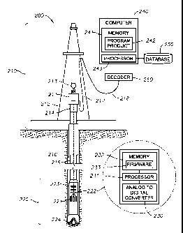
boundary A'B.
However, if it is determined that the trend of the boundaries may change after
the established
boundary (i.e., after position B in FIG. 3), the drilling of the drill bit 224
can follow a
-16-
CA 02854666 2014-05-05
WO 2013/074745
PCT/US2012/065211
modified extension of the newly established boundary. In accordance with an
embodiment of
the invention, the boundaries (i.e., the upper and lower boundaries of the pay
zone 340) can
also be updated by applying other geosteering tools in the operation of the
drill bit 224.
LEFT-RIGHT STEERING A DRILL BIT THROUGH A CHANNEL PAY ZONE:
100561 FIGS. 7,
8(a)-(c), 9, and 10 illustrate a procedure for steering a drill bit through a
channel pay zone using the geosteering system shown in FIG. 2, in accordance
with an
embodiment of the invention. In particular, FIG. 7 is a perspective view of a
diagram of a
path taken by a drill bit through a channel pay zone using acoustic signals
generated by the
drill bit drilling into rock, in accordance with an embodiment of the
invention. FIGS. 8(a)-(c)
are flow diagrams of a method performed by the geosteering system, as shown in
FIG. 2, for
left-right steering a drill bit through a channel pay zone, in accordance with
an embodiment
of the invention. FIG. 9 is a cross sectional area of a channel pay zone
having a material in a
channel which gradually becomes muddy toward the banks of the channel, in
accordance
with an embodiment of the invention. FIG. 10 is a diagram of predefined,
preliminary and
actual bank boundaries of a channel, in accordance with an embodiment of the
invention.
[00571 As shown in FIG. 7, for purposes of illustrating the procedure
described in FIGS.
8(a)-(c), a river channel 710, in accordance with an embodiment of the
invention, can
meander along its course (i.e., it is not straight). As further shown in FIG.
7, the vertical
position of the river channel 710 may also gradually vary along its course.
After being buried
in geological history, the vertical position of the river channel 710 may vary
more due to
changes caused by tectonic processes. Thus, the position of a geologically
ancient sand
channel buried in underground may vary vertically and laterally. FIG. 7, as an
example,
shows such a river channel 710 (e.g., a sand channel) with its position
varying laterally. In
accordance with an embodiment of the invention, the aim of geosteering a drill
bit 224
through the pay zone of the river channel 710 (hereinafter referred to as
"channel pay zone
710"), as shown in FIG. 7, is to keep the drill bit 224 following the channel
pay zone 710 in
both the lateral and vertical directions.
100581
Generally, a buried sand channel has a sharp lithological contrast with its
underlying and overlying sedimentary rocks (e.g., cap rock 330 and bed rock
350), which can
include, for example, mudstone or shale. As shown in FIG. 9, the cross
sectional area of the
lithology of the sand channel (i.e., of the channel pay zone 710) may
gradually change from
sand/sandstone to mudstone or shale toward the sand channel's banks. These
characteristics
-17-
CA 02854666 2014-05-05
WO 2013/074745
PCT/US2012/065211
of lithology variation in the vertical and horizontal direction can be used in
the steering of the
drill bit 224 by employing a drill bit acoustic logging tool 220, as described
above for FIG. 2.
100591 In
accordance with various embodiments of the invention, the drill bit 224 being
drilled through a channel pay zone 710 can be steered in both up-down and left-
right
directions. Up-down steering is performed using the procedure, as shown in
FIGS. 3, 4, and
5(a) and (b), described above.
100601 In accordance with an embodiment of the invention, FIG. 7 shows a
buried river
channel 710 with its cap rock 330 and bed rock 350. A lateral section 320 of
the channel pay
zone 710 can be side tracked from the vertical section 310. In FIG. 7, the
lateral section 320
can be drilled by following the middle of the channel pay zone 710 (i.e., the
well path is 0.5w
(w = the width of the channel) away from each bank. In accordance with certain
embodiments of the invention, the lateral section 320 of the channel pay zone
710 can follow
a different path, for example, along a path 0.4w away from the left bank or a
path 0.6w away
from the right bank, as non-limiting examples.
100611 In accordance with an embodiment of the invention, the acoustic
signatures 410,
420, 430, 440 (not shown) of the cap rock 330, the channel pay zone 710, the
bed rock 350,
and the banks 720, 730 of a well (AS) can be derived, at step 801-1, by (1)
conducting drill
bit acoustic logging, i.e., applying the apparatus to obtain the acoustic
signature, while
drilling a vertical section 310 (see FIG. 7) and a cross section (not shown)
of the well; or (2)
obtaining, at step 801-2, the acoustic signatures 410, 420, 430, 440 from
offset wells or a
database, as shown in FIG. 8(a).
100621 As further shown in FIG. 8(a), the preliminary boundaries between the
channel pay
zone 710 and its surrounding rocks (e.g., cap rock 330, bed rock 350, and
banks 720, 730),
and the channel pay zone's 710 lateral distribution along its course can be
derived, at step
802, from the information collected at steps 801-1 or 801-2. If a vertical
section 310 (see
FIG. 7) is drilled, at step 801-1, the boundary positions A, A' and the
channel pay zone 710
thickness at the vertical section 310 can be determined and updated (BT). If a
cross section is
drilled, at step 801-1, the boundaries between the channel pay zone 710 and
the banks 720,
730, and the channel pay zone 710 width at the cross section can be determined
and updated
(BT). Thus, in accordance with an embodiment of the invention, steps 801-1 and
801-2 can
be used to determine the prior information AS, BT, and thus the drilling of
the drill bit 224
-18-
CA 02854666 2014-05-05
WO 2013/074745
PCT/US2012/065211
through the lateral section 320 (see FIG. 7) can be steered by employing the
following
procedure.
100631 In accordance with an embodiment of the invention, the lateral section
320 (see
FIG. 7) can be drilled, at step 803, starting at a point positioned higher
than a middle depth of
the channel pay zone 710 along a predefined path (see FIG. 7). Drill bit
acoustic logging,
i.e., applying the apparatus to obtain the acoustic signature, can be
conducted whenever the
drilling is in operation. At step 804, the acoustic signature of the drilled
rock outputted from
the drill bit acoustic logging tool 220 can be compared against the known
acoustic signatures
410, 420 for the cap rock 330 and the channel pay zone 710, respectively (AS).
If the
observed acoustic signature of the drilled rock is the same as the known
acoustic signature
410 of the cap rock 330, but different from the known acoustic signature 420
of the channel
pay zone 710, the drill bit 224 has not entered the channel pay zone 710, and
thus is still
drilling in the cap rock 330, as decided at step 805. In this scenario, the
drill bit 224, at step
806-1, can continue to drill along the predefined path. Otherwise, if the
observed acoustic
signature of the drilled rock is different from the known acoustic signature
410 of the cap
rock 330, but the same as the known acoustic signature 420 of the channel pay
zone 710, the
drill bit 224 has entered and is drilling in the channel pay zone 710. In this
scenario, the drill
bit 224, at step 806-2, can continue drilling along the predefined path until
it reaches the
middle, or a preferred position, of the channel pay zone 710.
100641 In accordance with an embodiment of the invention, when the drill bit
224 reaches
the middle, or a preferred position, of the channel pay zone 710, lateral
drilling of the drill bit
224 through the well can begin. Based on whether the acoustic signature 420 of
the channel
pay zone 710 gradually changes toward the banks 720, 730, drilling of the
drill bit 224, at
step 807, can be steered in two different ways. For example, as shown in FIG.
8(a), if the
acoustic signature 420 of the channel pay zone 710 does not gradually change
toward the
banks 720, 730, the drilling of the drill bit 224, at step 808-1, can continue
laterally along the
predefined path parallel to one of the boundaries (i.e., the left or right
banks of the channel
pay zone 710). Otherwise, the drilling of the drill bit 224 can be
continuously adjusted, at
step 808-2, to keep the drill bit 224 drilling along an optimal path
(prolific) by comparing the
observed acoustic signature of the drilled rock against the known acoustic
signature 420 of
the channel pay zone, as shown in FIG. 8(a). For example, if the lithology of
the channel pay
zone 710 gradually changes toward one of the banks 720, 730 from a certain
position, as
shown in FIG. 9, the amplitude spectrum 420 of the channel pay zone 710 may be
gradually
-19-
CA 02854666 2014-05-05
WO 2013/074745
PCT/US2012/065211
changing from a pattern of good sandstone to a pattern of muddy sandstone, and
then to a
pattern of mudstone.
100651 In accordance with an embodiment of the invention, when the driller
determines
that the amplitude spectrum of the observed acoustic signature of the drilled
rock is gradually
changing from a pattern of good sandstone to a pattern of mudstone, the
driller knows that the
drill bit 224 may be gradually drifting away from the most prolific zone.
Accordingly, the
driller can then immediately take action to restore th.e drilling of the drill
bit 224 toward the
best zone (i.e., staying within the channel pay zone 710), resulting in a
lateral well with
maximum contact within the channel pay zone 710.
100661 As shown
in FIG. 8(b), during the lateral drilling, drill bit acoustic logging, i.e.,
applying the apparatus to obtain the acoustic signature, can be conducted and
the observed
acoustic signature of the drilled rock can be continuously compared, at step
809, against the
known acoustic signatures 410, 420, 430, 440 of the cap rock 330, the channel
pay zone 710,
the bed rock 350, and the banks 720, 730, respectively, to detei ____ mine, at
step 810, whether the
drill bit 224 is drilling within the channel pay zone 710. If the observed
acoustic signature of
the drilled rock is the same or similar to the known acoustic signature 420 of
the channel pay
zone 710, the drill bit 224 is still drilling in the channel pay zone 710. In
this scenario, the
drill bit 224 can be operated, at step 811-1, to continue drilling along its
current path. If it is
determined that the drill bit 224 is drilling out of the channel pay zone 710,
a determination
can be made as to which direction that the drill bit 224 is drilling out of
the channel pay zone
710. For example, in accordance with an embodiment of the invention, if the
observed
acoustic signature of the drilled rock is the same as or similar to the known
acoustic signature
410 of the cap rock 330, it can be determined, at step 811-2, that the drill
bit 224 is drilling
out of the top of the channel pay zone 710 into the cap rock 330; and
therefore, the drill bit
224 can be to be steered, at step 812-1, back into the channel pay zone 710
using the up-down
steering method, as shown in FIGS. 5(a) and (b).
100671 As
further shown in FIG. 8(b), if it is determined that the drill bit 224 is not
drilling
out of the top of the channel pay zone 710, then the drill bit 224 may either
be drilling toward
a bank 720, 730 or the bed rock 350. To differentiate these different
possibilities, it must be
determined, at step 812-2, whether the acoustic signatures of the rocks at the
bed rock 350
and the bank 720, 730 are distinguishably different from one another. If they
are
distinguishably different, then it can be determined, based on this
difference, which direction
the drill bit 224 is drilling by comparing the observed acoustic signature of
the drilled rock
-20-
CA 02854666 2014-05-05
WO 2013/074745
PCT/US2012/065211
against the known acoustic signatures 430, 440 of the bed rock 350 and the
banks 720, 730.
If the observed acoustic signature of the drilled rock is the same or similar
to that of the bed
rock 350, then the driller can determine, at step 813-2, that the drill bit
224 is drilling out of
the base of the channel pay zone 710 into the bed rock 350. In this scenario,
the drill bit 224
can be steered back toward the channel pay zone 710 by following step 812-1.
If the acoustic
signature of the drilled rock is the same or similar to the acoustic signature
440 of the rock at
the banks 720, 730, then the driller can determine that the drill bit 224 is
drilling out of the
channel pay zone 710 from the banks 720, 730; and therefore, the drill bit 224
can be steered
back into the middle, or a prolific position, of the channel pay zone 710 by
following step
815.
100681 If, at step 812-2, it is detei ____________________________ mined
that the acoustic signatures of the bed rock 350
and the bank 720, 730 are not distinguishably different, then the drilling
direction of the drill
bit 224 can be determined using a trial and error approach. In accordance with
an
embodiment of the invention, the trial and error approach includes operating,
at step 813-1,
the drill bit 224 to drill upward for a short distance, and then comparing the
observed acoustic
signature of the drilled rock against the acoustic signature 420, 430 of the
channel pay zone
710 and the bed rock 350 to determine whether the drill bit 224 is re-entering
the channel pay
zone 710. If it is determined, in step 814, that the drill bit 224 is re-
entering the channel pay
zone 710, the drill bit 224 was drilling out of the base of the channel pay
zone 710; and
therefore, the drill bit 224 can be steered back into the channel pay zone 710
by following
step 812-1. If it is deteiiiiined, in step 814, that the drill bit 224 is not
re-entering the channel
pay zone 710, the drill bit 224 was drilling out of the channel pay zone 710
from one of the
banks 720, 730; and therefore, the drill bit 224 can be steered back into the
middle, or a
prolific position, of the channel pay zone 710 by following step 815.
100691 In accordance with an embodiment of the invention, when redirecting the
drill bit
224 from the bank 720, 730 into the center of the channel pay zone 710, the
driller can decide
which side (e.g., the left or right bank 720, 730) (see FIG. 9) the drill bit
224 is drilling away
from the channel pay zone 710. In accordance with an embodiment of the
invention,
information, such as the channel lateral distribution (BT), the acoustic
signatures of the left
and right bank 440 (AS), if they are different, can help the driller derive,
in step 815, a
prejudged drill bit relative position. The driller can now steer, in step 816,
the drill bit 224
toward the center of the channel pay zone 710 in the opposite direction of the
prejudged drill
bit relative position. For example, if the driller determines that the drill
bit 224 is drilling into
-21-
CA 02854666 2014-05-05
WO 2013/074745
PCT/US2012/065211
the left bank 720 (see FIG. 10), the driller can steer the drill bit 224 right
toward the center of
the channel pay zone 710.
100701 As shown in FIG. 8(c), when drilling "toward the center" of the channel
pay zone
710, the observed acoustic signature of the drilled rock can be compared, at
step 817, against
the acoustic signature 420, 440 of the channel pay zone 710 and the banks 720,
730,
respectively, to determine, at step 818, whether the drill bit 224 has re-
entered the channel
pay zone 710. If it is determined that the drill bit 224 shortly enters the
channel pay zone
710, the driller can determine that the prejudgment of the relative position
of the drill bit 224
is correct. At step 819-1, based on the determination that the prejudgment of
the relative
position of the drill bit 224 was correct, the confirmed boundary position and
the acoustic
signature 440 of the rock at the banks 720, 730 can be updated. For example,
in FIG. 7, if the
driller determined, using the above procedure, that the drill bit 224 is
drilling out the channel
pay zone 710 at a boundary position B, the preliminary boundary position
derived before the
lateral drilling can be precisely determined at the point B. The boundary
position at the
opposite position B' can also now be estimated more accurately (i.e., assuming
that the width
of the channel pay zone 710 is known). If the prejudgment of the relative
position of the drill
bit 224 is correct, the drill bit 224 is operated, at step 820-1, to continue
drilling until it
reaches the center, or a preferred position, of the channel pay zone 710 along
a possible
shortest path.
100711 In
accordance with an embodiment of the invention, if, after drilling "toward the
center" of the channel pay zone 710 for a reasonable distance, the acoustic
signature of the
drilled rock shows, at step 817, that the drill bit 224 is entering the bank
720, 730, the pre-
judgment of the relative position of the drill bit 224 can be determined to be
incorrect. For
example, in FIG. 10, when the drill bit 224 is at a point P and it reaches one
of the banks 720,
730, if the relative position of the drill bit 224 has been prejudged
incorrectly as being at the
right bank 730, the driller can steer the drill bit 224 left toward the
"center" of the channel
pay zone 710, as indicated by the dashed arrow at point P in FIG. 10. If the
drill bit 224 is
actually at the left bank 720, the drill bit 224 would be entering the left
bank 720 instead of
leaving it, based on the direction of drilling. In this case, the prejudged
drill bit relative
position can be corrected, at step 819-2. For the example in FIG. 10, the
drill bit relative
position at point P can be positioned at the left bank 720 instead of the
right bank 730.
Accordingly, the absolute boundary position at point P. and the acoustic
signature 440 of the
rock at the banks 720, 730 can be updated, at step 819-2. The drilling of the
drill bit 224 can
-22-
CA 02854666 2014-05-05
WO 2013/074745
PCT/US2012/065211
then be redirected, at step 820-2, toward the center, or a preferred position,
of the channel pay
zone 710 along a possible shortest path.
100721 If the drill bit 224 has been drilled through the channel pay zone 710
from one
boundary to the opposite side, as, for example, from B to C and C to D, as
shown in FIG. 7,
the spectrum of the acoustic signature 420 of the channel pay zone 710 in the
lateral direction
(although not at the same location) can be determined and updated (AS), at
step 821.
100731 In accordance with an embodiment of the invention, the width of the
channel pay
zone 710 can be estimated and updated during drilling (BT), at step 821. For
example, when
steering the drill bit 224 from a bank 720 or 730 boundary toward the center
of the channel
pay zone 710, if the drill bit 224 drills into a transitional zone before it
reaches the anticipated
center of the channel pay zone 710, the width has been overestimated and can
be adjusted and
updated (BT), at step 821.
100741 In accordance with an embodiment of the invention, the thickness of the
channel
pay zone 710 can also be estimated and updated during drilling (BT), at step
821. For
example, when steering the drill bit 224 from the upper boundary toward the
center of the
channel pay zone 710, if the drill bit 224 drills into the lower boundary
before it reaches the
anticipated center of the channel pay zone 710, the thickness has been
overestimated and can
be adjusted and updated (BT), at step 821.
100751 After
the drill bit 224 reaches the center, or a preferred position, of the channel
pay
zone 710, the drill bit 224 can be steered by following an iterative process
beginning at step
807, until the drill bit 224 has been drilled through the channel pay zone 710
over a planned
length of the channel pay zone 710.
100761 In accordance with an embodiment of the invention, during drilling, the
bank
boundaries at some points, such as B, C and D in FIG. 7, can be accurately
determined, while
the points at the opposite boundaries, such as B', C' and D', can also be
accurately estimated
based on the determined bank boundary points and the known width of the
channel pay zone
710.
100771 Accordingly, embodiments of the invention provide non-obvious
advantages over
conventional geosteering systems. Conventional geosteering systems use
information 30-50
feet behind the drill bit to steer the drill bit, and therefore are not real-
time techniques.
Embodiments of the invention use information at the drill bit to steer it, and
therefore provide
-23-
CA 02854666 2014-05-05
WO 2013/074745
PCT/US2012/065211
a truly real-time technique, which provides non-obvious advantages over
conventional
geosteering systems.
100781 The
present invention may suitably comprise, consist or consist essentially of the
elements disclosed and may be practiced in the absence of an element not
disclosed. For
example, it can be recognized by those skilled in the art that certain steps
can be combined
into a single step.
100791 Unless
defined otherwise, all technical and scientific terms used have the same
meaning as commonly understood by one of ordinary skill in the art to which
this invention
belongs.
[00801 The
singular forms "a", "an," and "the" include plural referents, unless the
context
clearly dictates otherwise.
100811 As used herein and in the appended claims, the words "comprise," "has,"
and
"include" and all grammatical variations thereof are each intended to have an
open, non-
limiting meaning that does not exclude additional elements or steps.
100821
"Optionally" means that the subsequently described event or circumstances may
or
may not occur. The description includes instances where the event or
circumstance occurs
and instances where it does not occur.
100831 Ranges may be expressed herein as from about one particular value,
and/or to
about another particular value. When such a range is expressed, it is to be
understood that
another embodiment is from the one particular value and/or to the other
particular value,
along with all combinations within said range.
100841 Although
the present invention has been described in detail, it should be
understood that various changes, substitutions, and alterations can be made
hereupon without
departing from the principle and scope of the invention. Accordingly, the
scope of the
present invention should be determined by the following claims and their
appropriate legal
equivalents.
-24-