Note : Les descriptions sont présentées dans la langue officielle dans laquelle elles ont été soumises.
CA 02860316 2014-08-21
1 SYSTEM AND METHOD FOR SPACE FILLING REGIONS OF AN IMAGE
2 TECHNICAL FIELD
3 [0001] The following relates generally to image processing and more
specifically to space
4 filling techniques to render a region of an image of a physical space
using other regions of the
image.
6 BACKGROUND
7 [0002] In design fields such as, for example, architecture, interior
design, and interior
8 decorating, renderings and other visualisation techniques assist
interested parties, such as, for
9 example, contractors, builders, vendors and clients, to plan and validate
potential designs for
physical spaces.
11 [0003] Designers commonly engage rendering artists in order to sketch
and illustrate
12 designs to customers and others. More recently, designers have adopted
various digital
13 rendering techniques to illustrate designs. Some digital rendering
techniques are more realistic,
14 intuitive and sophisticated than others.
[0004] When employing digital rendering techniques to visualise designs
applied to existing
16 spaces, the rendering techniques may encounter existing elements, such
as, for example,
17 furniture, topography and clutter, in those spaces.
18 SUMMARY
19 [0005] In visualising a design to an existing physical space, it is
desirable to allow a user to
capture an image of the existing physical space and apply design changes and
elements to the
21 image. However, when the user removes an existing object shown in the
image, a void is
22 generated where the existing object stood. The void is unsightly and
results in a less realistic
23 rendering of the design.
24 [0006] In one aspect, a system is provided for space filling regions
of an image of a physical
space, the system comprising a rendering unit operable to generate a tileable
representation of
26 a sample region of the image and replicating the tileable representation
across a target region in
27 the image.
28 [0007] In another aspect, a method is provided for space filling
regions of an image of a
29 physical space, the method comprising: (1) in a rendering unit,
generating a tileable
1
CA 02860316 2014-08-21
1 representation of a sample region of the image; and (2) replicating the
tileable representation
2 across a target region in the image.
3 [0008] In embodiments, a system is provided for assigning world
coordinates to at least one
4 point in an image of a physical space captured at a time of capture by an
image capture device.
The system comprises a rendering unit configured to: (i) ascertain, for the
time of capture, a
6 focal length of the image capture device; (ii) determine, in world
coordinates, for the time of
7 capture, an orientation of the image capture device; (iii) determine, in
world coordinates, for the
8 time of capture, a distance between the image capture device and a
reference point in the
9 physical space; and (iv) generate a view transformation matrix comprising
matrix elements
determined by the focal length, the orientation and the distance to enable
transformation
11 between the coordinate system of the image and the world coordinates.
12 [0009] In further embodiments, the system for assigning world
coordinates is configured to
13 space fill regions of the image, the rendering unit being further
configured to: (i) select, based on
14 user input, a sample region in the image; (ii) map the sample region to
a reference plane; (iii)
generate a tileable representation of the sample region; (iv) select, based on
user input, a target
16 region in the reference plane; and (v) replicate the tileable
representation of the sample region
17 across the target region.
18 [0010] In still further embodiments, the rendering unit is
configured to determine the
19 distance between the image capture device and the reference point by:
(i) causing a reticule to
be overlaid on the image using a display unit; (ii) obtaining from a user by a
user input device
21 the known length and orientation in world coordinates of a line
corresponding to a captured
22 feature of the physical space; (iii) adjusting the location and size of
the reticule with respect to
23 the image in response to user input provided by the user input device;
(iv) obtaining from the
24 user by the user input device an indication that the reticule is aligned
with the line; and (iv)
determining the distance from the image capture device to the reference point,
based on the
26 size and orientation of the reticule and the size and orientation of the
line.
27 [0011] In embodiments, the rendering unit is configured to
determine the distance from the
28 image capture device to the reference point by: (i) determining that a
user has placed the image
29 capture device on a reference plane; (ii) determining the acceleration
of the image capture
device as the user moves the image capture device from the reference plane to
an image
31 capture position; (iii) deriving the distance of the image capture
device from the reference plane
32 from the acceleration; and (iv) determining the distance between the
image capture device and
2
CA 02860316 2014-08-21
1 the reference point, based on the focal length of the image capture
device and the distance of
2 the image capture device from the reference plane.
3 [0012] In further embodiments, the rendering unit is configured to
determine the distance
4 from the image capture device to the reference point by requesting user
input of an estimated
distance from the image capture device to a reference plane.
6 [0013] In yet further embodiments, the rendering unit determines the
orientation in world
7 coordinates of the image capture device by: (i) obtaining acceleration of
the image capture
8 device from an accelerometer of the image capture device; (ii)
determining from the acceleration
9 when the image capture device is at rest; and (iii) assigning the
acceleration at rest as a proxy
for the orientation in world coordinates of the image capture device.
11 [0014] In embodiments, the rendering unit generates the tileable
representation of the
12 sample region by using a Poisson gradient-guided blending technique. The
tileable
13 representation of the sample region may comprise four sides and the
rendering unit enforces
14 identical boundaries for all four sides of the tileable representation
of the sample region.
[0015] In further embodiments, the rendering unit replicates the tileable
representation of
16 the sample region across the target area by applying rasterisation.
17 [0016] In still further embodiments, the rendering unit generates
ambient occlusion for the
18 target area.
19 [0017] In embodiments, a method is provided for assigning world
coordinates to at least one
point in an image of a physical space captured at a time of capture by an
image capture device,
21 the method comprising a rendering unit: (i) ascertaining, for the time
of capture, a focal length of
22 the image capture device; (ii) determining, in world coordinates, for
the time of capture, an
23 orientation of the image capture device; (iii) determining, in world
coordinates, for the time of
24 capture, a distance between the image capture device and a reference
point in the physical
space; and (iv) generating a view transformation matrix comprising matrix
elements determined
26 by the focal length, the orientation and the distance to enable
transformation between the
27 coordinate system of the image and the world coordinates.
28 [0018] In further embodiments, a method is provided for space filling
regions of an image,
29 comprising the method for assigning world coordinates to at the least
one point in the image of
the physical space and comprising the rendering unit further: (i) selecting,
based on user input,
31 a sample region; (ii) mapping the sample region to a reference plane;
(iii) generating a tileable
3
CA 02860316 2014-08-21
1 representation of the sample region; (iv) selecting, based on user input,
a target region in the
2 reference plane; and (v) replicating the tileable representation of the
sample region across the
3 target region.
4 [0019] In still further embodiments, the rendering unit in the
method for assigning world
coordinates to at least one point in an image of the physical space determines
the distance
6 between the image capture device and the reference point by: (i) causing
a reticule to be
7 overlayed on the image using a display unit; (ii) obtaining from a user
by a user input device the
8 known length and orientation in world coordinates of a line corresponding
to a captured feature
9 of the physical space; (iii) adjusting the location and size of the
reticule with respect to the
image in response to user input on the user input device; (iv) obtaining from
the user by the user
11 input device an indication that the reticule is aligned with the line;
and (v) determining the
12 distance from the image capture device to the reference point, based on
the size and orientation
13 of the reticule and the size and orientation of the line.
14 [0020] In embodiments, the rendering unit in the method for
assigning world coordinates to
at least one point in an image of the physical space determines the distance
from the image
16 capture device to the reference point by: (i) determining that a user
has placed the image
17 capture device on a reference plane; (iii) determining the acceleration
of the image capture
18 device as the user moves the image capture device from the reference
plane to an image
19 capture position; (iv) deriving the distance of the image capture device
from the reference plane
from the acceleration; and (iv) determining the distance between the image
capture device and
21 the reference point, based on the focal length of the image capture
device and the distance of
22 the image capture device from the reference plane.
23 [0021] In further embodiments, the rendering unit in the method
for assigning world
24 coordinates to at least one point in an image of the physical space
determines the distance from
the image capture device to the reference point by requesting user input of an
estimated
26 distance from the image capture device to a reference plane.
27 [0022] In still further embodiments, the rendering unit in the method
for assigning world
28 coordinates to at least one point in an image of the physical space
determines the orientation in
29 world coordinates of the image capture device by: (i) obtaining
acceleration of the image
capture device from an accelerometer of the image capture device; (ii)
determining from the
31 acceleration when the image capture device is at rest; and (iii)
assigning the acceleration at rest
32 as a proxy for the orientation in world coordinates of the image capture
device.
4
CA 02860316 2014-08-21
1 [0023] In embodiments, the rendering unit in the method for
assigning world coordinates to
2 at least one point in an image of the physical space generates the
tileable representation of the
3 sample region comprises by using a Poisson gradient-guided blending
technique. In further
4 embodiments, the tileable representation of the sample region comprises
four sides and the
rendering unit enforces identical boundaries for all four sides of the
tileable representation of the
6 sample region.
7 [0024] In yet further embodiments, the rendering unit in the
method for assigning world
8 coordinates to at least one point in an image of the physical space
replicates the tileable
9 representation of the sample region across the target area by applying
rasterisation.
[0025] In embodiments, the rendering unit in the method for assigning world
coordinates to
11 at least one point in an image of the physical space further generates
ambient occlusion for the
12 target area.
13 DESCRIPTION OF THE DRAWINGS
14 [0026] A greater understanding of the embodiments will be had with
reference to the
Figures, in which:
16 [0027] Fig. 1 illustrates an example of a system for space filling
regions of an image;
17 [0028] Fig. 2 illustrates an embodiment of the system for space
filling regions of an image;
18 [0029] Fig. 3 is a flow diagram illustrating a process for
calibrating a system for space filling
19 regions of an image;
[0030] Figs. 4-6 illustrate embodiments of a user interface module for
calibrating a system
21 for space filling regions of an image;
22 [0031] Fig. 7 illustrates a flow diagram illustrating a process
for space filling regions of an
23 image; and
24 [0032] Figs. 8-10 illustrate embodiments of a user interface
module for space filling regions
of an image.
26 DETAILED DESCRIPTION
27 [0033] Embodiments will now be described with reference to the
figures. It will be
28 appreciated that for simplicity and clarity of illustration, where
considered appropriate, reference
29 numerals may be repeated among the figures to indicate corresponding or
analogous elements.
In addition, numerous specific details are set forth in order to provide a
thorough understanding
5
CA 02860316 2014-08-21
1 of the embodiments described herein. However, it will be understood by
those of ordinary skill in
2 the art that the embodiments described herein may be practiced without
these specific details.
3 In other instances, well-known methods, procedures and components have
not been described
4 in detail so as not to obscure the embodiments described herein. Also,
the description is not to
be considered as limiting the scope of the embodiments described herein.
6 [0034] It will also be appreciated that any module, unit,
component, server, computer,
7 terminal or device exemplified herein that executes instructions may
include or otherwise have
8 access to computer readable media such as storage media, computer storage
media, or data
9 storage devices (removable and/or non-removable) such as, for example,
magnetic disks,
optical disks, or tape. Computer storage media may include volatile and non-
volatile, removable
11 and non-removable media implemented in any method or technology for
storage of information,
12 such as computer readable instructions, data structures, program
modules, or other data.
13 Examples of computer storage media include RAM, ROM, EEPROM, flash
memory or other
14 memory technology, CD-ROM, digital versatile disks (DVD) or other
optical storage, magnetic
cassettes, magnetic tape, magnetic disk storage or other magnetic storage
devices, or any
16 other medium which can be used to store the desired information and
which can be accessed
17 by an application, module, or both. Any such computer storage media may
be part of the device
18 or accessible or connectable thereto. Any application or module herein
described may be
19 implemented using computer readable/executable instructions that may be
stored or otherwise
held by such computer readable media and executed by the one or more
processors.
21 [0035] Referring now to Fig. 1, an exemplary embodiment of a
system for space filling
22 regions of an image of a physical space is depicted. In the depicted
embodiment, the system is
23 provided on a mobile tablet device 101. However, aspects of systems for
space filling regions of
24 an image may be provided on other types of devices, such as for,
example, mobile telephones,
laptop computers and desktop computers.
26 [0036] The mobile tablet device 101 comprises a touch screen 104.
Where the mobile tablet
27 device 101 comprises a touch screen 104, it will be appreciated that a
display unit 103 and an
28 input unit 105 are integral and provided by the touch screen 104. In
alternate embodiments,
29 however, the display unit and the input unit may be discrete units. In
still further embodiments,
the display unit and some elements of the user input unit may be integral
while other input unit
31 elements may be remote from the display unit. For example, the mobile
tablet device 101 may
32 comprise physical switches and buttons (not shown).
6
CA 02860316 2014-08-21
1 [0037] The mobile tablet device 101 further comprises: a rendering
unit 107 employing a ray
2 tracing engine 108; an image capture device 109, such as, for example, a
camera or video
3 camera; and an accelerometer 111. In embodiments, the mobile tablet
device may comprise
4 other suitable sensors (not shown).
[0038] The mobile tablet device may comprise a network unit 141 providing,
for example,
6 Wi-Fi, cellular, 3G, 4G, Bluetooth and/or LTE functionality, enabling
network access to a
7 network 151, such as, for example, the Internet or a local intranet. A
server 161 may be
8 connected to the network 151. The server 161 may be linked to a database
171 for storing data,
9 such as models of furniture, finishes, floor coverings and colour
swatches relevant to users of
the mobile tablet device 101, users including, for example, architects,
designers, technicians
11 and draftspersons. In aspects, the actions described herein as being
performed by the
12 rendering unit may further or alternatively be performed outside the
mobile tablet device by the
13 server 161 on the network 151.
14 [0039] In aspects, one or more of the aforementioned components of
the mobile tablet
device 101 is in communication with, and remote from, the mobile tablet device
101.
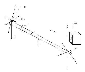
16 [0040] Referring now to Fig. 2, an image capture device 201 is shown
pointing generally
17 toward an object 211 in a physical space. The image capture device 201
has its own coordinate
18 system defined by X-, Y- and Z- axes, where the Z-axis is normal to the
image capture device
19 lens 203 and where the X-, Y-, and Z-axes intersect at the centre of the
image capture device
lens 203. The image capture device 201 may capture an image which includes
portions of at
21 least some objects 211 having at least one known dimension, which fall
within its field of view.
22 [0041] The field of view is defined by the view frustum, as shown.
The view frustum is
23 defined by: the focal length F along the image capture device Z-axis,
and the lines emanating
24 from the centre of the image capture device lens 203 at angles a to the
Z-axis. On some image
capture devices, including mobile tablet devices and mobile telephones, the
focal length F and,
26 by extension, the angles a, are fixed and known, or ascertainable. In
certain image capture
27 devices, the focal length F is variable but is ascertainable for a given
time, including at the time
28 of capture.
29 [0042] It will be appreciated that the rendering unit must reconcile
multiple coordinate
systems, as shown in Fig. 2, such as, for example, world coordinates, camera
(or image capture
31 device) coordinates, object coordinates and projection coordinates. The
rendering unit is
32 configured to model the image as a 3-dimensional (3D) space by assigning
world coordinates to
7
CA 02860316 2014-08-21
1 one or more points in the image of the physical space. The rendering unit
assigns world
2 coordinates to the one or more points in the image by generating a view
transformation matrix
3 that transforms points on the image to points having world coordinates,
and vice versa. The
4 rendering unit is operable to generate a view transformation matrix to
model, for example, an
image of a physical space appearing in 2D on the touchscreen of a mobile
tablet device.
6 [0043] The rendering unit may apply the view transformation matrix to
map user input
7 gestures to the 3D model, and further to render design elements applied
to the displayed image.
8 [0044] The view transformation matrix is expressed as the product of
three matrices: VTM =
9 N =T = R, where VTM is the view transformation matrix, N is a
normalisation matrix, T is a
translation matrix and R is a rotation matrix. In order to generate the view
transformation matrix,
11 the rendering unit must determine matrix elements through a calibration
process, a preferred
12 mode of which is shown in Fig. 3 and hereinafter described.
13 [0045] As shown in Fig. 3, at block 301, in a specific example, the
user uses the image
14 capture device to take a photograph, i.e., capture an image, of a
physical space to which a
design is to be applied. The application of a design may comprise, for
example, removal and/or
16 replacement of items of furniture, removal and/or replacement of floor
coverings, revision of
17 paint colours or other suitable design creations and modifications. The
space may be generally
18 empty or it may contain numerous items, such as, for example, furniture,
people, columns and
19 other obstructions, at the time the image is captured.
[0046] In Fig. 2, the image capture device is shown pointing generally
downward in relation
21 to world coordinates. In aspects, the rendering unit performs a
preliminary query to the
22 accelerometer while the image capture device is at rest in the capture
position to determine
23 whether the image capture device is angled generally upward or downward.
If the test returns
24 an upward angle, the rendering unit causes the display unit to display a
prompt to the user to re-
capture the photograph with the image capture device pointing generally
downward.
26 [0047] At block 303, the rendering unit generates the normalisation
matrix N, which
27 normalises the view transformation matrix according to the focal length
of the image capture
28 device. As previously described, the focal length for a device having a
fixed focal length is
29 constant and known, or derivable from a constant and known half angle a.
If the focal length of
the image capture device is variable, the rendering unit will need to
ascertain the focal length or
31 angle of the image capture device for the time of capture. The
normalisation matrix N is defined
32 for a given half-angle a is defined as:
8
CA 02860316 2014-08-21
F1/tan a 0 0 0
1 0 1/tan a 0 , where a is the half angle of the image capture
device's field of view.
0 0 1 0
0 0 0 1
2 [0048] At
block 305, the rendering unit generates the rotation matrix R. The rotation
matrix
3
represents the orientation of the image capture device coordinates in relation
to the world
4 coordinates. The image capture device comprises an accelerometer configured
for
communication with the rendering unit, as previously described. The
accelerometer provides an
6
acceleration vector G, as shown in Fig. 2. When the image capture device is at
rest, any
7
acceleration which the accelerometer detects is solely due to gravity. The
acceleration vector G
8
corresponds to the degree of rotation of the image capture device coordinates
with respect to
9 the
world coordinates. At rest, the acceleration vector G is parallel to the world
space z-axis.
The rendering unit can therefore assign the acceleration at rest as a proxy
for the orientation in
11 world coordinates of the image capture device.
12 [0049] The
rendering unit derives unit vectors NX and NY from the acceleration vector G
13 and the image capture device coordinates X and Y:
x G
NX = _________________________________________
YXGI
axxx
N-Y =
x A-7.v1
14
The resulting rotation vector appears as follows:
-N X.x \Y ..r G.x 0-
Za.y NY.y G..y 0
N- X z 1V-Y a.z o
16 _o U U 1_.
17 [0050] At
block 307, the rendering unit generates the translation matrix T. The
translation
18
matrix accounts for the distance at which the image capture device coordinates
are offset from
19 the
world coordinates. The rendering unit assigns an origin point 0 to the view
space, as shown
in Fig. 2. The assigned origin projects to the centre of the captured space,
i.e., along the image
21
capture device Z-axis toward the centre of the image captured by the image
capture device at
9
CA 02860316 2014-08-21
1 block 301. The rendering unit assumes that the origin is on the "floor"
of the physical space, and
2 assigns the origin a position in world coordinates of (0, 0, 0). The
origin is assigned a world
3 space coordinate on the floor of the space captured in the image so that
the only possible
4 translation is along the image capture device's Z-axis. The image capture
device's direction is
thereby defined as: NX = Z,NY = Z, d = z, 0. The displacement along that axis
is represented in the
6 resulting translation matrix:
1 0 0 0
0 1 0 0
0 0 1 D
7 -0 0 0 1 -, where D represents the distance, for the time of capture,
between the image
8 capture device and a reference point in the physical space.
9 [0051] The value for D is initially unknown and must be ascertained
through calibration or
other suitable technique. At block 309, the rendering unit causes a reticule
401 to be overlaid on
11 the image using the display unit, as shown in Fig. 4. The rendering unit
initially causes display of
12 the reticule to correspond to a default orientation, size and location,
as shown. For example, the
13 default size may be 6 feet, as shown at prompt 403.
14 [0052] As shown in Figs. 3 and 4, at block 311 a prompt 403 is
displayed on the display unit
to receive from the user a reference dimension and orientation of a line
corresponding to a
16 visible feature within the physical space. For example, as illustrated
in Figs. 3 and 4, the
17 dimension of the line may correspond to the distance in world
coordinates between the floor and
18 the note paper 405 on the dividing wall 404. In aspects, a visible door,
bookcase or desk sitting
19 on the floor having a height known to the user could be used as visible
features. The user
selects the size of the reference line by scrolling through the dimensions
listed in the selector
21 403; the rendering unit will then determine that the reticule
corresponds to the size of the
22 reference line.
23 [0053] As shown in Fig. 4, the reticule 401 is not necessarily
initially displayed in alignment
24 with the reference object. As shown in Fig. 3, at blocks 313 to 317, the
rendering unit receives
from the user a number of inputs described hereinafter to align the reticule
401. At block 313,
26 the rendering unit receives a user input, such as, for example, a finger
gesture or single finger
27 drag gesture, or other suitable input technique to translate the
reticule to a new position. At
28 block 315, the rendering unit determines the direction that a ray would
take if cast from the
29 image capture device to the world space coordinates of the new position
by applying to the user
CA 02860316 2014-08-21
1 input gesture the inverse of the previously described view transformation
matrix. The rendering
2 unit then determines the x- and y-coordinates in world space where the
ray would intersect the
3 floor (z=0). The rendering unit applies those values to calculate the
following translation matrix
4 that would bring the reticule to the position selected by the user:
1 0 0 X
0 1 0 Y
o 0 1 0
_0 0 0 1
6 [0054] At block 317, the rendering unit rotates the reticule in
response to a user input, such
7 as, for example, a two-finger rotation gesture or other suitable input.
The rendering unit rotates
8 the reticule about the world-space z-axis by angle 8 by applying the
following local reticule
9 rotation matrix:
cos(0) ¨ sin(0) 0 0-
sin(0) cos(60) 0 0
0 0 1 0
0 0 0 1
11 [0055] The purpose of this rotation is to align the reticule along
the base of the reference
12 object, as shown in Fig. 5, so that the orientation of the reticule is
aligned with the orientation of
13 the reference line. When the user has aligned the reticule 501 with the
reference object 511, its
14 horizontal fibre 503 is aligned with the intersection between the
reference object 511 and the
floor 521, its vertical fibre 507 extends vertically from the floor 521
toward, and intersecting with,
16 the reference point 513, and its normal fibre 505 extends
perpendicularly from the reference
17 object 511 along the floor 521.
18 [0056] Recalling that the reticule was initially displayed as a
default size to which the user
19 assigned a reference dimension, as previously described, it will be
appreciated that the initial
height of the marker 509 may not necessarily correspond to the world
coordinate height of the
21 reference point 513 above the floor 521. Referring again to Fig. 3, at
block 319, the rendering
22 unit responds to further user input by increasing or decreasing the
height of the marker 509. In
23 aspects, the user adjusts the height of the vertical fibre 507 to align
the marker 509 with the
24 reference point 513 by, for example, providing a suitable touch gesture
to slide a slider 531, as
shown, so that the vertical fibre 507 increases or decreases in height as the
user moves the
26 slider bead 533 up or down, respectively; however, other input methods,
such as arrow keys on
11
CA 02860316 2014-08-21
1 a fixed keyboard, or mouse inputs could be implemented to effect the
adjustment. Once the
2 user has aligned the marker 509 of the reticule 507 with the reference
point 513, the rendering
3 unit can use the known size, location and orientation of each of the
reticule and the line to solve
4 the view transformation matrix for the element D. A fully calibrated
space is shown in Fig. 6.
[0057] Once the rendering unit has determined the view transformation
matrix, the
6 rendering unit may begin receiving design instructions from the user and
applying those
7 changes to the space.
8 [0058] In further aspects, other calibration techniques may be
performed instead of, or in
9 addition to, the calibration techniques described above. In at least one
aspect, the rendering unit
first determines that a user has placed the image capture device on the floor
of the physical
11 space. Once the image capture device is at rest on the floor, the user
lifts it into position to
12 capture the desired image of the physical space. As the user moves the
device into the capture
13 position, the rendering unit determines the distance from the image
capture device to the floor
14 based on the acceleration of the image capture device. For example, the
rendering unit
calculates the double integral of the acceleration vector over the elapsed
time between the floor
16 position and the capture position to return the displacement of the
image capture device from
17 the floor to the capture position. The accelerometer also provides the
image capture device
18 angle with respect to the world coordinates to the rendering unit once
the image capture device
19 is at rest in the capture position, as previously described. With the
height, focal length, and
image capture device angle with respect to world coordinates known, the
rendering unit has
21 sufficient data to generate the view transformation matrix.
22 [0059] In still further aspects, the height of the image capture
device in the capture position
23 is determined by querying from the user the user's height. The rendering
unit assumes that the
24 image capture device is located a distance below the user's height, such
as for example, 4
inches, and uses that location as the height of the image capture device in
the capture position.
26 [0060] Alternatively, the rendering unit queries from the user an
estimate of the height of the
27 image capture device from the floor.
28 [0061] It will be appreciated that the rendering unit may also
default to an average height off
29 the ground, such as, for example, 5 feet, if the user does not wish to
assist in any of the
aforementioned calibration techniques.
12
CA 02860316 2014-08-21
1 [0062] In aspects, the user may wish to apply a new flooring
design to the image of the
2 space, as shown in Fig. 8; however, the captured image of the space may
comprise obstacles,
3 such as, for example the chair 811 and table 813 shown. If the user would
like to view a
4 rendering of the captured space without the obstacles, the rendering unit
needs to space fill the
regions on the floor where the obstacles formerly stood.
6 [0063] In Fig. 7, a flowchart illustrates a method for applying
space filling regions of the
7 captured image. At block 701, the user selects a sample region to
replicate across a desired
8 region in the captured image. As shown in Fig. 8, the rendering unit
causes the display unit to
9 display a square selector 801 mapped to the floor 803 of the captured
space. The square
selector 801 identifies the sample region of floor 803. In aspects, the square
selector 801 is
11 semi-transparent to simultaneously illustrate both its bounding area and
the selected pattern, as
12 shown. In alternate embodiments, however, the square selector 801 may be
displayed as a
13 transparent region with a defined border (not shown). In further
aspects, a viewing window 805
14 is provided to display the selected area to the user at a location on
the display unit, as shown.
The rendering unit translates and flattens the pixels of the sample region
bounded by the square
16 selector 801 into the viewing window 805, and, in aspects, updates the
display in real-time
17 according to the user's repositioning of the selector.
18 [0064] The user may: move the selector 801 by dragging a finger or
cursor over the display
19 unit; rotate the selector 801 using two-finger twisting input gestures
or other suitable input;
and/or scale the selector 801 by using, for example, a two-finger pinch. As
show in Fig. 7 at
21 block 703, the rendering unit applies the following local scaling matrix
to scale the selector:
s 0 0 0
0.900
0 0 S 0
22 0 0 0 1_
23 [0065] Once the user has selected a sample region to replicate,
the user defines a target
24 region in the image of the captured space to which to apply the pattern
of the sample region, at
block 705 shown in Fig. 7. The rendering unit causes a closed, non-self
intersecting vector-
26 based polygon 901 to be displayed on the display unit, as shown in Fig.
9. In order to ensure
27 that the polygon 901 always defines an area, rather than a line, the
polygon 901 comprises at
28 least three control points 903. The user may edit the polygon 901 by
adding, removing and
29 moving the control points 903 using touch gestures or other suitable
input methods, as
13
CA 02860316 2014-08-21
1 described herein. In aspects, the control points 903 can be moved
individually or in groups. In
2 still further aspects, the control points may 903 be snapped to the edges
and corners of the
3 captured image, providing greater convenience to the user.
4 [0066]
After the user has finished configuring the polygon, the rendering unit
applies the
pattern of the selected region to the selected target region, as shown in Fig.
7 at blocks 707 and
6 709. At block 707, the rendering unit generates a tileable representation
of the pattern in the
7 sample region, using suitable techniques, such as, for example, the
Poisson gradient-guided
8 blending technique described in Patrick Perez, Michel Gangnet, and Andrew
Blake. 2003.
9 Poisson image editing. ACM SIGGRAPH 2003 Papers (SIGGRAPH '03). ACM, New
York, NY,
USA, 313-318. Given a rectangular sample area, such as the area bounded by the
selector 801
11 shown in Fig. 8, the rendering unit generates a tileable, i.e.,
repeatable, representation of the
12 sample region by setting periodic boundary values on its borders. In
aspects, the rendering unit
13 enforces identical boundaries for all four sides of the square sample
region. When the tileable
14 representation is replicated, as described below, the replicated tiles
will thereby share identical
boundaries with adjacent tiles, reducing the apparent distinction between
tiles.
16 [0067]
At block 709, the rendering unit replicates the tile across the target area by
applying
17 rasterisation, such as, for example, the OpenGL rasteriser, and applying
the existing view
18 transformation matrix to the vector-based polygon 901, shown in Fig. 9
using a tiled texture map
19 consisting of repeated instances of the tileable representation
described above.
[0068] In
aspects, the rendering unit enhances the visual accuracy of the modified image
21 by generating ambient occlusion for the features depicted therein, as
shown in at blocks 711 to
22 7. The rendering unit generates the ambient occlusion in cooperation
with a ray tracing engine.
23 At block 719, the rendering unit receives from the ray tracing engine
ambient occlusion values,
24 which it blends with the rasterised floor surface. In aspects, the
rendering unit further enhances
visual appeal and realism by blending the intersections of the floor and the
walls from the
26 generated image with those shown in the originally captured image.
27 [0069]
At block 711, the rendering unit infers that the polygon 901, as shown in Fig.
9,
28 represents the floor of the captured space, and that objects bordering
the target region are wall
29 surfaces. The rendering unit applies the view transformation matrix to
determine the world
space coordinates corresponding to the display coordinates of the polygon 901
and generates a
31 3D representation of the space by extruding virtual walls
perpendicularly from the floor along the
32 edges of the polygon 901. As shown in Fig. 7 at block 713, the rendering
unit provides the
14
CA 02860316 2014-08-21
1 resulting virtual geometries to a ray tracing engine. The rendering unit
only generates virtual
2 walls that meet the following condition: the virtual walls must face
toward the inside of the
3 polygon 901, and the virtual walls must face the user, i.e., towards the
image capture device.
4 These conditions are necessary to ensure that the rendering unit does not
extrude virtual walls
that would obscure the rendering, as will be appreciated below.
6 [0070] The rendering unit determines the world coordinates of the
bottom edge of a given
7 virtual wall by projecting two rays from the image capture device to the
corresponding edge of
8 the target area. The rays provide the world space x and y coordinates for
the virtual wall where
9 it meets the floor, i.e., at z=0. The rendering unit determines the
height for the given virtual wall
by projecting a ray through a point on the upper border of the display unit
directly above the
11 display coordinate of one of the end points of the corresponding edge.
The ray is projected
12 along a plane that is perpendicular to the display unit and that
intersects the world coordinate of
13 the end point of the corresponding edge. The rendering unit calculates
the height of the virtual
14 wall as the distance between the world coordinate of the end point and
the world coordinate the
ray directly above the end point.
16 [0071] In cooperation with the rendering unit, the ray tracing
engine generates an ambient
17 occlusion value for the floor surface. At block 713, the rendering unit
transmits the virtual
18 geometry generated at block 711 to the ray tracing engine. At block 715,
the ray tracing engine
19 casts shadow rays from a plurality of points on the floor surface toward
a vertical hemisphere.
For a given point, any ray emanating therefrom which hits one of the virtual
walls represents
21 ambient lighting that would be unavailable to that point. The proportion
of shadow rays from the
22 given point that would hit a wall to the shadow rays that would not hit
a wall is a proxy for the
23 level of ambient light at the given point on the floor surface.
24 [0072] Because the polygon may only extend to the borders of the
display unit, any virtual
walls extruded from the edges of the polygon will similarly only extend to the
borders of the
26 display unit. However, this could result in unrealistic brightening
during ray tracing, since the
27 shadow rays cast from points on the floor space toward the sides of the
display unit will not
28 encounter virtual walls past the borders. Therefore, in aspects, the
rendering unit extends the
29 virtual walls beyond the borders of the display unit in order to reduce
the unrealistic brightening.
[0073] In aspects, the ray tracing engine further enhances the realism of
the rendered
31 design by accounting for colour bleeding, at block 717. The ray tracing
engine samples the
32 colour of the extruded virtual walls at the points of intersection of
the extruded virtual walls with
CA 02860316 2014-08-21
1 all the shadow rays emanating from each point on the floor. For a given
point on the floor, the
2 ray tracing engine calculates the average of the colour of all the points
of intersection for that
3 point on the floor. The average provides a colour of virtual light at
that point on the floor.
4 [0074] In further aspects, the ray tracing engine favours
generating the ambient occlusion
for the floor surface, not the extruded virtual geometries. Therefore, the ray
tracing engine casts
6 primary rays without testing against the extruded geometry; however, the
ray tracing engine
7 tests the shadow rays against the virtual walls of the excluded geometry.
This simulates the
8 shadow areas of low illumination typically encountered where the virtual
walls meet the floor
9 surface.
[0075] It will be appreciated that ray tracing incurs significant
computational expense. In
11 aspects, the ray tracing engine reduces this expense by calculating the
ambient occlusion at a
12 low resolution, such as, for instance, at 5 times lower resolution than
the captured image. The
13 rendering unit then scales up to the original resolution the ambient
occlusion obtained at lower
14 resolution. In areas where the ambient occlusion is highly variable from
one sub-region to the
next, the rendering unit applies a bilateral blurring kernel to prevent
averaging across dissimilar
16 sub-regions.
17 [0076] As shown in Fig. 10, the systems and methods described
herein for space-filling
18 regions of the captured image provide an approximation of the captured
space with the
19 obstacles removed.
[0077] Although the invention has been described with reference to certain
specific
21 embodiments, various modifications thereof will be apparent to those
skilled in the art. The
22 scope of the claims should not be limited by the preferred embodiments,
but should be given the
23 broadest interpretation consistent with the description as a whole.
24
16