Note : Les descriptions sont présentées dans la langue officielle dans laquelle elles ont été soumises.
CA 02886808 2015-03-30
WO 2014/084952
PCT/US2013/060052
SYSTEM AND METHOD FOR VELOCITY ANOMALY ANALYSIS
BACKGROUND
Field
[0001] The present invention relates generally to seismic imaging and more
particularly to velocity model correction.
Background
[0002] Seismic surveying is used to characterize subsurface formations and
in
particular for locating and characterizing potential hydrocarbon reservoirs.
One or more
seismic sources at the surface generate seismic signals that propagate through
the
subsurface, reflect from subsurface features, and are collected by sensors.
Raw data is
generally in the form of travel times and amplitudes, which must be processed
in order to
obtain information about the structure of the subsurface.
[0003] Typically, processing includes inversion of the collected time
information to
produce a velocity model of the subsurface structure. Because there are
usually multiple
velocity solutions that satisfactorily explain any given set of time data, it
is not always
known whether the velocity models accurately depict the subsurface structure.
In some
circumstances, there may be localized regions in which the velocity is highly
non-
homogeneous. The non-homogeneity may result from presence of local high or low
velocity zones in the subsurface structure.
[0004] Clathrates are substances in which a lattice structure made up of
first
molecular components (host molecules) that trap or encage one or more other
molecular
components (guest molecules) in what resembles a crystal-like structure. In
the field of
hydrocarbon exploration and development, clathrates of interest are generally
clathrates
in which hydrocarbon gases are the guest molecules in a water molecule host
lattice.
They can be found in relatively low temperature and high pressure
environments,
including, for example, deepwater sediments and permafrost areas.
SUMMARY
[0005] An aspect of an embodiment of the present invention includes a
method of
analyzing a seismic image of a subsurface region, including obtaining a
velocity model
and a seismic image for the subsurface region, smoothing the velocity model to
produce a
1
CA 02886808 2015-03-30
WO 2014/084952
PCT/US2013/060052
smoothed velocity model, subtracting the velocity model from the smoothed
velocity
model to create an anomaly velocity model, and creating a hybrid anomaly
velocity
model based on the anomaly velocity model and the seismic image.
[0006] An aspect of an embodiment of the present invention includes a
system
including a graphical user interface, a data storage device and a processor,
the processor
being configured to perform the foregoing method.
[0007] Aspects of embodiments of the present invention include computer
readable
media encoded with computer executable instructions for performing any of the
foregoing
methods and/or for controlling any of the foregoing systems.
DESCRIPTION OF THE DRAWINGS
[0008] Other features described herein will be more readily apparent to
those skilled
in the art when reading the following detailed description in connection with
the
accompanying drawings, wherein:
[0009] Figure 1 is a hybrid image combining velocity anomaly information
with
amplitude information;
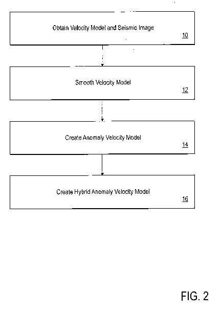
[00010] Figure 2 is a flowchart illustrating a method of analyzing a seismic
image in
accordance with an embodiment of the invention;
[00011] Figure 3 is another hybrid image combining velocity anomaly
information
with amplitude information;
[00012] Figure 4 is a flowchart illustrating a method of analyzing a seismic
image in
accordance with an embodiment of the invention; and
[00013] Figure 5 is a schematic illustration of a computing system for use in
analyzing
a seismic image in accordance with an embodiment of the invention.
DETAILED DESCRIPTION
[00014] Velocity models may include anomalies as a result of a variety of
factors
present in the subsurface under study. The inventors have developed tools for
characterization of subsurface conditions and structures based on velocity
anomaly data.
2
CA 02886808 2015-03-30
WO 2014/084952
PCT/US2013/060052
CLATHRATE DEPOSIT IDENTIFICATION
[00015] In an embodiment, velocity anomaly may be used as part of a method for
identifying clathrate deposits. In mud prone sediments, clathrates are often
broadly
distributed in low concentrations. In sand prone environments, however, it may
be that
higher concentrations of clathrates are more likely to form, given sufficient
charge.
Because these environments tend to be located in relatively shallow subsurface
regions,
where vertical velocity gradients tend to be high due to compaction, it may be
difficult to
identify velocity variations that would indicate high concentrations of
clathrate. The
inventors have developed a method of analysis of a velocity anomaly field to
improve
detection and localization of high velocity materials that may correspond to
useful
clathrate deposits, which themselves tend to be high velocity compared to
marine
sediment in which they may appear. By way of example, marine sediments at
relevant
depths have a velocity between about 1700-2000 m/s while clathrates may have
velocities
around 3000 m/s.
[00016] In an embodiment, an anomaly model is produced and overlain on a
seismic
image to produce a hybrid anomaly velocity model as illustrated in Figure 1.
In a method
in accordance with an embodiment, as shown in the flowchart of Figure 2,
seismic
velocity analysis techniques are used to define a velocity model for the
subsurface region.
The analysis may include, for example, normal moveout (NMO) based stacking
velocity
picking, or other approaches. Alternately, tomographic velocity analysis
including, for
example, traveltime tomography or tomographic velocity inversion may be used.
[00017] Once the velocity field is obtained 10, it is spatially smoothed 12
using long
spatial wavelength smoothing. In an embodiment, during the smoothing, vertical
resolution is maintained. As an example, this smoothing may be produced using
a
function of the average of all velocity measurements from a selected water
bottom. This
smoothed velocity field will be used as a background velocity field to aid in
the
identification of anomalous regions. Typically, software packages that are
used in
velocity modeling include functionality for smoothing. As an example, GOCAD,
available from Paradigm Geophysical of Houston, Texas includes such
functionality,
though other commercially available or custom software implementations may be
used.
3
CA 02886808 2015-03-30
WO 2014/084952
PCT/US2013/060052
[00018] Once the smoothed field is generated, it is subtracted from the
original
velocity field 14, and the resulting field may be considered to be an anomaly
field or
anomaly model. That is, because the velocity field contains more high
frequency
information, and the smoothed field represents the low frequency information,
the
remaining high frequency information after subtraction is more likely to
represent
anomalous structures (i.e., structures that are notably higher or lower
velocity than the
background).
[00019] Once the anomaly model has been produced, it is overlain on the
seismic stack
as illustrated in Figure 1, to create a hybrid anomaly velocity model. In an
embodiment,
the anomaly model is visualized via a color image in which color is indicative
of an
anomaly velocity level. The seismic stack image is a black and white image in
which
brightness is indicative of amplitude of a reflected signal.
[00020] The combined anomaly model and seismic stack image may then be used to
identify areas in which the stack amplitudes show channel-like geometry that
are also
anomalous velocity areas. In particular, if the anomaly information indicates
a high
velocity area and the stack image indicates a channel geometry, those areas
are more
likely to include clathrate deposits than are areas with channel geometry that
do not have
high velocity anomalies.
[00021] Additional cues may be incorporated into the identifying. For example,
clathrates are generally known to be present within particular depth ranges
because they
are stable within a specific pressure and temperature envelope. Locations
meeting these
criteria may be referred to as clathrate stability zones. In deepwater
settings, this is
usually within a shallow zone beneath the seafloor. Therefore, if high
velocity anomaly
and channel-like geometries are found at large depths, they may be ignored or
assigned
reduced likelihood of clathrate presence.
[00022] Those regions that have high anomaly, channel-like structure and lie
within an
appropriate depth range are then flagged for further interpretation by an
expert and/or for
application of a different analysis method.
[00023] In the example illustrated in Figure 1, the bright region A near the
surface
represents a channel-like structure (recognizable from the seismic image) that
also
4
CA 02886808 2015-03-30
WO 2014/084952
PCT/US2013/060052
includes a bright coloring (purple and white in the original color image),
corresponding to
fast velocities.
[00024] In an embodiment, an amplitude envelope is defined, and applied to the
image
in order to identify likely possibilities for further review by a seismic
interpretation
expert.
[00025] In an embodiment, a threshold for velocity anomaly value is set, and a
pattern
recognition algorithm is applied to the image, to identify contiguous regions
in which the
velocity anomaly threshold value is exceeded. These regions are further culled
by
application of depth criteria, eliminating those regions that are below a base
of the
clathrate stability zone. Finally, edges of the identified velocity anomalies
are tested to
determine whether they are coincident with high amplitude seismic signals
indicating the
likelihood that the high anomaly zone represents a physical subsurface
structure. These
computer-identified zones may then be further reviewed by the seismic image
analysis
expert.
[00026] In an embodiment, decisions on exploitation of the identified
clathrates may
be made based on the analysis. For example, exploratory drilling decisions may
be made.
Likewise, management decisions including methodology for production such as
use of
dissociation-promoting techniques, pre-compaction of the producing region, and
the like
may be based on the images of the deposits.
STRATIGRAPHIC IMAGING
[00027] Typically, tomographic techniques are able to resolve local low or
high
velocity zones but may not be effective in resolving precise vertical or
lateral extent of an
anomaly. Therefore, in an embodiment, anomaly analysis of the velocity field
as
illustrated in Figure 3 may be used to assist in resolving subsurface
structures within local
high and/or low velocity zones, and vice versa.
[00028] First, as shown in the flowchart of Figure 4, using a tomography
technique, a
velocity model is defined 20 and a seismic image is obtained 22. For example,
prestack
depth migration analysis may be used, though other tomographic techniques can
alternately be used.
CA 02886808 2015-03-30
WO 2014/084952
PCT/US2013/060052
[00029] Once the velocity field is obtained, it is spatially smoothed 24
using long
spatial wavelength smoothing. In an embodiment, during the smoothing, vertical
resolution is maintained.
[00030] The tomographic field is subtracted from the smoothed field to create
an
anomaly volume or anomaly model 26. The velocity model is then overlain on a
seismic
stack image as in the previous application to generate a hybrid velocity
amplitude model
28.
[00031] Once the hybrid velocity amplitude model is produced, stratigraphic or
structural features that are coincident with anomalies are identified. As
described above,
this identification may be performed by an expert viewing the data on a
computing
device. In principle, automated pattern recognition processes may be used
either to
identify the features or may be used to pre-screen for features that are to be
further
examined by the expert.
[00032] A human interpreter defines a geobody within the image. In Figure 3,
the
geobody is defined by the black outline. This geobody may be defined in any
appropriate
manner. For example, the interpreter may use an input device such as a mouse
or pad
device to identify edges of the geobody. In principle, image analysis software
may be
used to identify geobodies based on pattern recognition algorithms. Where
automated
approaches are pursued, a human interpretation step may be used to refine the
automatically identified geobodies.
[00033] Once the geobody is defined, it may be populated with the appropriate
velocity anomaly. As will be appreciated, prior to the use of geobody
definition of the
anomaly, it may be poorly defined, and the measured anomaly may extend beyond
(either
in depth or in extent) the geologically reasonable location for the anomaly.
This can be
observed in Figure 3 in that the anomaly (bright portions of the anomaly
model) extends
beyond the edges of the defined geobody. That is, edges of measured anomalies
tend to
be blurred and/or mispositioned within the region. By constraining the
location of the
anomaly to the location of an interpreted geobody, the velocity model may be
refined to
better reflect the likely subsurface structure. With respect to the model of
Figure 3, that
portion of the anomaly extending beyond the top of the geobody would be
reduced or
6
CA 02886808 2015-03-30
WO 2014/084952
PCT/US2013/060052
eliminated while portions of low anomaly that are within the geobody may be
increased
to equal the high anomaly present throughout the remainder of the geobody.
[00034] The anomaly model, once constrained by location of identified
geobodies, is
then added back to the background (smoothed) velocity model to produce a
modified
velocity model. This new product may then be used to remigrate the seismic
data to
produce a new seismic image. Optionally, once the new seismic image is
produced, the
process may be iterated or the model otherwise refined via additional rounds
of
tomography.
[00035] A system for performing the method is schematically illustrated in
Figure 5.
A system includes a data storage device or memory 202. The stored data may be
made
available to a processor 204, such as a programmable general purpose computer.
The
processor 204 may include interface components such as a display 206 and a
graphical
user interface 208. The graphical user interface may be used both to display
data and
processed data products and to allow the user to select among options for
implementing
aspects of the method. Data may be transferred to the system 200 via a bus 210
either
directly from a data acquisition device, or from an intermediate storage or
processing
facility (not shown).
[00036] While the method is described and illustrated in the context of two
dimensional images, the principles of the method are applicable to three
dimensional
analysis as well.
[00037] As will be appreciated, the methods as described herein may be
performed
using a computing system having machine executable instructions stored on a
tangible,
non-transitory medium. The instructions are executable to perform each portion
of the
method, either autonomously, or with the assistance of input from an operator.
In an
embodiment, the system includes structures for allowing input and output of
data, and a
display that is configured and arranged to display the intermediate and/or
final products
of the process steps. A method in accordance with an embodiment may include an
automated selection of a location for exploitation and/or exploratory drilling
for
hydrocarbon resources. Where the term processor is used, it should be
understood to be
applicable to multi-processor systems and/or distributed computing systems.
7
CA 02886808 2015-03-30
WO 2014/084952
PCT/US2013/060052
[00038] Those skilled in the art will appreciate that the disclosed
embodiments
described herein are by way of example only, and that numerous variations will
exist.
The invention is limited only by the claims, which encompass the embodiments
described
herein as well as variants apparent to those skilled in the art. In addition,
it should be
appreciated that structural features or method steps shown or described in any
one
embodiment herein can be used in other embodiments as well.
8