Note : Les descriptions sont présentées dans la langue officielle dans laquelle elles ont été soumises.
CA 02898390 2015-07-27
LOW-COST, HIGH-PERFORMANCE RADAR NETWORKS
FIELD OF THE INVENTION
This invention relates to land-based radar surveillance of wide areas or local
sites. It also
relates to radar detection and tracking and multi-sensor fusion.
BACKGROUND OF THE INVENTION
ilomeland Security" refers to the goal of detecting and defending against
threats to public
safety posed by potential attack by hostile individuals or groups. Homeland
Security
I() applications for radar surveillance differ fundamentally from most
military applications. The
high price of military radars is justified by the critical and urgent need for
protection in
combat zones or near high-value assets. The price is affordable because the
deployments are
confined in time and/or space. Homeland Security, in contrast, deals with
threats, such as
terrorist attacks, that materialize infrequently and can occur anywhere.
Surveillance to
counter such threats must be deployed simultaneously across huge areas on a
permanent 24/7
basis. Therefore, in the market for sensors used for Homeland Security
surveillance, low-cost
is not just a competitive advantage, it is a fundamental requirement.
Homeland Security includes such applications as border patrol, law
enforcement, critical
infrastructure protection (both corporate and public facilities),
transportation security, port
security and coastal surveillance. All of these applications require cost-
effective detection
and tracking of small, fast, maneuvering, elusive targets. Targets of interest
include (but are
not limited to) small watercraft in littoral regions, and snowmobiles on snow
or ice cover, or
other vehicles. Al the present time, low-cost radar systems suitable for these
homeland
security applications are not operational.
Altogether different problems that also require cost-effective detection and
tracking of small,
fast, maneuvering, elusive targets are the bird air strike hazard (BASH)
problem and the
natural resource management (NRM) problem concerning birds. Billions of
dollars in
damage to aircraft and significant loss of life have been recorded due to
birds flying into
aircraft, particularly during take-off and landing in the vicinity of
airports. At the present
time, low-cost radar systems suitable for these avian radar applications are
under
development.
CA 02898390 2015-07-27
2
Practical solutions for the aforementioned applications must be able to
provide continuous,
day or night, all w eather. wide-area situational awareness with automated
detection,
localization and warnings of threats. The wide-area situational awareness
points towards a
network of radars operating together to provide a composite picture. The
automated warning
of threats points toward high-quality target track data with sophisticated
criteria to determine
suspicious or potentially dangerous target behavior, as well as communication
of alerts to
users who require that information. Furthermore, practical solutions must also
minimize
operator interaction due to the fact that system cost includes the cost of
human labor needed
to operate the system.
Some of the key requirements of the cited applications include:
= Low-cost, high-performance radar antennas and transceivers that can be
mounted on
land-based towers as well as on mobile vehicles and vessels.
= Radar processing that can reliably detect and track small, low-RCS,
maneuvering
targets in dense target and clutter environments.
= Automatic threat detection and alert capability to remote users
= The formation of radar networks to provide wide-area coverage
= Low cost of operation
= Low life cycle costs
= Data and analysis support for research and development
While X-band or S-band coherent radar technology used in air traffic control
and military
radars could be integrated. reconfigured and optimized to satisfy performance
requirements
for the aforementioned applications, such systems would not be affordable.
Typically, each
radar sensor would cost in the millions of dollars, not taking into account
the life cycle costs
of maintaining and operating such systems. The purpose of the invention
disclosed herein is
to provide a low-cost radar surveillance solution to these problems, where the
radar sensor
would cost as little as $50,000 or less.
Commercial, off-the-shelf (COTS) marine radars (from companies such as Furuno.
Raymarine, Decca, etc.) are very inexpensive due to the fact that they are
noncoherent and
that millions of them are sold world-wide for use on commercial and
recreational vessels. A
radar antenna and transceiver can be purchased for under $10,000, depending on
the
transmitter power and antenna selected. These marine radars exhibit
surprisingly good
hardware specifications such as transmitter power, receiver characteristics
and antenna
CA 02898390 2015-07-27
3
pattern. I lowever, in operation, these radars deliver mediocre performance
for our targets of
interest because of their primitive signal processing. They are primarily used
for detecting
large vessels and shorelines for navigation and collision avoidance purposes.
Combining a COTS marine radar with a digitizer board and a software radar
processor that
runs on a COTS personal computer (PC) can allow a marine radar to be adapted
for other
applications. One vendor [Rutter Technologies, www.ruttertech.com] has
developed a radar
processor for such a system [the Sigma S6 Processor] where the radar processor
is tuned for
detecting slow-moving floating ice targets (such as ice bergs or bergy bits)
in the sea by using
scan-to-scan integration techniques over time frames of 20 seconds to 160
seconds (to
improve signal to clutter ratio (SCR)) combined with an alpha-beta tracker
designed for non-
maneuvering targets. This system has been designed for maritime operation on-
board a vessel
or moored platform and hence does not deal with the formation of radar
networks, does not
solve the small-RCS, fast, maneuvering target problem, and does not provide
low-cost of
operation since an operator is needed for each system. In addition, alerts
are not
automatically provided to remote users for unattended operation.
SUMMARY OF THE INVENTION
The present invention concerns radar surveillance networks applied to homeland
security and
avian radar applications. The invention aims to provide a land-based, radar
system that is
low-cost and high-performance for Homeland Security, BASH and NRM
applications. The
invention contemplates sophisticated radar signal and data processing
algorithms that can
reliably detect and track small, low-RCS, maneuvering targets, including small
watercraft,
snowmobiles, birds and aircraft, in dense target and clutter environments.
The present invention more particularly involves a low-cost, high performance
radar sensor
that can be networked with other like and dissimilar sensors to form low-cost,
high-
performance radar networks with situational awareness and \\ ide-area
coverage. The
invention seeks to use sophisticated radar processing combined with spatial
diversity
(associated with the location of radar sensors making up a radar network),
which allows the
performance of a low-cost, noncoherent radar system to approach that of much
more
expensive coherent radar systems.
The present invention aims to take advantage of standardized COTS technologies
to the
CA 02898390 2015-07-27
4
maximum extent possible to keep the system cost low and to provide for low
life cycle costs
associated with maintainability, upgrade ability and training. The intent is
to use COTS
marine radars as the radar sensor in order to minimize sensor costs.
Pursuant to the present invention, the radar sensors and systems are software-
configurable so
as to allow them to be easily adapted for different applications. Operator
interaction is
minimized in order to reduce the cost of operation.
The present invention additionally contemplates that the radar sensors and
system can be
controlled remotely, that the system supports remote users with different user
requirements,
and that the system can provide automated threat detection and issue alerts to
local and remote
users.
The present invention intends that radar target data are geo-referenced using
a geographic
information system (GIS) so that target data is tagged to earth co-ordinates
and target
dynamics including speed and heading are provided.
The present invention further intends that the radar system incorporates
features that
efficiently support research and development and off-line analysis, allowing
for example,
target behavior to be studied so that target classification algorithms can be
developed, or
allowing target data to be studied and replayed after the fact, to assist, for
example, in the
prosecution of terrorists.
Accordingly, the present invention relates to the design of a low-cost, high-
performance, land-
based radar sensor and a radar network consisting of one or more of these
radar sensors
designed for homeland security and avian radar applications. These challenging
applications
and some of the features and performance of the present invention have been
reported in
[Weber. P et al., Low-cost radar surveillance of inland waterways for homeland
security
applications, 2004 IEEE Radar Conference, April 26-29, 2004, Philadelphia, PA
1 and
[Nohara. T .1 et al. Affordable avian radar surveillance systems for natural
resource
management and BASH applications, 2005 IEEE International Radar Conference,
May 9-12,
2005, Arlington. VAI.
CA 02898390 2015-07-27
A feature of the present invention is the preferred use of COTS marine radars
to provide
economical antennas and transceivers that operate at X-band and S-band. COTS
marine
radars exhibit surprisingly good hardware specifications such as transmitter
power, receiver
characteristics and antenna pattern. low ever, in operation (for homeland
security and avian
5 radar applications) these radars deliver mediocre performance because of
their primitive
signal processing. The first part of our invention is to create an inexpensive
radar sensor with
high performance by integrating a sophisticated radar processor with COTS
marine radar
equipment. The radar processor itself incorporates sophisticated algorithms
and software that
runs preferably on COTS personal computers (PC) to keep costs down. The system
design of
the invention described herein demonstrates that affordable COTS marine radars
combined
with COTS personal computers (PCs) With specialized software can provide
powerful
surveillance systems.
For the cited applications, which are the focus of this disclosure, targets of
interest include
small watercraft, snowmobiles, and birds. These small, fast moving and
maneuvering, non-
cooperative targets have low (and fluctuating) radar cross-sections (RCS), and
compete with
ground (e.g. land, snow, ice cover, urban features), water and weather
clutter. COTS marine
radars are designed for navigation and recreational use and, as such, have low
small-target
detection sensitivity. The presence of many friendly targets further
complicates matters and
the tracking circuits included with these radars are completely inadequate for
our targets of
interest. To detect these small targets with these marine radars, surveillance
operators would
need to observe the display over several consecutive radar scans in order to
begin to assess the
situation at hand. This is a difficult task that causes operator fatigue very
quickly, is not
reliable, and hence is not used in practice. To
mitigate these problems, our invention
digitizes the raw radar video signal from the marine radar receiver and uses a
PC-based radar
processor with sophisticated processing to achieve significantly improved
performance. The
radar processor of the subject invention incorporates a detection processor, a
track processor,
and a display processor. Prior art processors have used significant amounts of
scan-to-scan
integration to increase the SCR and thereby improve detection sensitivity for
small, slow-
moving targets such as ice bergs, berg' bits, and capsized vessels or persons-
in-water. These
prior art systems exploit the fact that the radars are mounted on vessels and
that sea clutter
decorrelates over a relatively short time. Scan-to-scan integration is not
applicable to the fast-
movini2, targets of interest of the present invention for two fundamental
reasons: I) the targets
move out or the radar resolution cell due to fast movement. and 2) the land
clutter that
CA 02898390 2015-07-27
6
dominates detection due to the fact that the radar sensors are land-based does
not dccorrelate
as quickly as sea clutter. As a result, a different approach must be adopted
to improve
detection sensitivity. Rather than emphasize the steady ground returns with
scan-to-scan
integration, they are preferably removed with an adaptive clutter map. This is
an important
part of pre-detection radar processing when detecting in and around ground
clutter. Ground
clutter usually originates through mainbeam illumination when the antenna beam
is pointed
horizontally or looking down from a tower. Even for cases where the antenna is
pointed up,
for example, to detect birds, clutter originates from the antenna elevation
sidelobes. After
most clutter has been suppressed, the detection processor of the present
invention produces
detections (also called plots) by setting lower detection thresholds than
conventional
processors, and thus is able to detect smaller targets. The
consequence of using lower
detection thresholds is that an undesired, higher false alarm rate results,
particularly due to the
strong clutter residual in the vicinity of the land-based radars used in the
present invention.
The track processor of the present invention depends on sophisticated
association and track
filtering algorithms that are designed to handle both the high false alarm
rate and
maneuvering targets. These approaches are unique to the present invention.
The plot-to-track association algorithm provides means to resolve ambiguities
produced by
multiple targets, missed detections, false alarms, and maneuvering targets,
whereas the track
filtering algorithm provides high quality estimates of target dynamics for the
association
algorithms and for the display processor. While the track filtering algorithm
performs well
With non-maneuvering targets, it uses special algorithms to handle maneuvering
targets and
this feature is unique to the present invention. The track processor
preferably uses a
sophisticated plot-to-track association algorithm called MKT [D.H.Reid, "An
algorithm for
tracking multiple targets", IEEE Transactions on Automatic Control, vol. AC-
24, no. 6. Dec.
1979, pp. 843-8541 and preferably uses an advanced track filtering algorithm
called
Interacting Multiple Model (IMM) filtering [G.A.Watson and W.D.Blair, "1MM
algorithm for
tracking targets that maneuver through coordinates turns", Proceedings of the
SPIE (Society
of Photo-Optical Instrumentation Engineers, vol. 1698, Signal and Data
Processing of Small
Targets, April 20-22, 1992, pp. 236-247]. It is understood that this invention
includes
schemes wherein the association algorithm is replaced by alternate techniques
known to those
skilled in the art and described in the literature including [S. S. Blackman,
Multiple-Target Tracking with Radar Applications, Artech 1-louse, 1986], and
wherein the
track filtering algorithm is replaced by alternate techniques known to experts
in the field and
CA 02898390 2015-07-27
7
described in the literature including [S.S.Blackman, Multiple-Target Tracking
with Radar
Applications, Artech House, 1986]. Furthermore. this invention also includes
schemes where
the association and track filtering algorithms are combined into a single
algorithm such as the
Probabalistic Data Association algorithm and its numerous variants [Y. Bar-
Shalom.
"Tracking methods in a multitarget environment: survey' paper", IEEE
Transactions on
Automatic Control, vol. AC-23, no. 4, Aug. 1978, pp.618-626], [S.S.Blackman.
Multiple-
Target Tracking with Radar Applications, Artech House, 19861.
For homeland security and avian radar applications, one radar, or even several
independently
operating radars is often not enough to provide a high-performance, composite
tactical picture
for a wide area of interest. For any single radar, there are gaps in coverage
due to
obstructions; and the area covered may not be a wide enough area. Thus the
second part of
our invention is to network radars to a central monitoring station (CMS), and
then integrate
(and/or fuse) target data from all of them. A single system is suitable for
monitoring a
geographically close group of sites or even a fairly large waterway. Multiple
systems can be
further networked together to provide integrated coverage of extended routes
or border
regions. Mobile systems are appropriate for monitoring regions needing more
intermittent
coverage, The benefits of fusion algorithms to further improve track quality
will become
apparent in the sequel. The networking of a number of land-based radar sensors
(each
consisting preferably of a COTS marine radar combined with a sophisticated
radar processor)
and the fusion of their target data to provide improved tracking performance
is a novel and
unique feature of the present invention.
A major challenge of continuous, wide-area surveillance is the high cost of
human effort to
monitor sensor displays. The networking of radar sensor target data to a CMS
reduces the
human costs significantly, since monitoring can be done far more efficiently
at a single CMS
than at the individual radar sensor sites. However, further reductions in
human operator costs
are desirable, especially in applications such as border patrol, w here vast
regions of border
have little or no target activity for extended periods of time. In such cases,
another feature of
the present invention is particularly valuable. The track data produced by
system of the
present invention contains detailed (but compact) long-term behavior
information on
individual targets. For any given scenario, these data can be automatically
tested for
suspicious activity. in order to generate alerts to security personnel.
Because the information
is detailed, alerts can reflect complex behavior, such as collision
predictions, origins and
CA 02898390 2015-07-27
8
destinations of vessels, perimeter approaches or violations, density of
traffic, etc. The low-
bandwidth track and alert information can be easily sent to central locations,
and directly to
end users, providing economical, effective monitoring. A novel feature of the
present
invention is the provision of automated alerts to remote users who require
them. This enables
the radar surveillance system to run unattended \vith users alerted only when
necessary.
Furthermore, track displays can be provided to remote users to give them a
clear picture of the
situation when alerts arise. The invention preferably exploits COTS
communication
technology to provide such remote alerts and displays inexpensively.
Further human cost reductions can be achieved with the present invention
through the
provision of hardware and software to remotely control the operation of each
radar sensor,
including the operation of each sensor's radar processor, as well as the
operation of its marine
radar transceiver. A novel feature of the present invention is the remote
control of each radar
sensor to reduce the human cost of operating and maintaining the radar network
of radar
sensors.
The applications towards which the present invention is directed require
further research and
development (R&D) in order to increase and establish knowledge concerning
target behavior.
This knowledge can be used, for example, for automatic target identification.
Off-line
analysis of target data can be used with ground truth data to better
understand bird signatures,
for example, which could then be used to develop bird identification
algorithms. In BASH
applications, knowing the kind of bird that is being tracked is valuable for
forming an
appropriate response (e.g. should aircraft delay take-offs and landings or
make an evasive
maneuver to increase safety). In homeland security applications, target
identification could be
very useful in determining whether a real threat exists when a target
approaches a security
perimeter near some critical infrastructure. Another example would be to
perform off-line
statistical analyses of target data in order to learn routes and patterns
characterizing criminal
activity in border areas. A novel feature of the present invention is the
ability to continuously
store complete target detection and track data over extended periods of time
in order to
support such R&D activities. Another novel feature of the present invention is
the ability to
rapidly play back stored target data into the radar processor in order to
study and analyze the
data. Prior art systems (particularly those employing COTS marine radars) do
not provide
such support for R&D activities.
CA 02898390 2015-07-27
9
BRIEF DESCRIPTION OF THE DRAWING
Figure 1 is a block diagram of a radar sensor apparatus included in a radar
surveillance
system, in accordance with the present invention.
Figure 2 is a block diagram of a radar controller that may be incorporated
into the radar sensor
apparatus of Figure I, in accordance with present invention.
Figure 3 is a block diagram of a remote controller for a Faun() FR2155BB radar
system, in
accordance with the present invention.
Figure 4 is a block diagram showing a radar network incorporating plural
instances of the
radar sensor apparatus of Figure I. 2, and/or 3, in accordance with the
present invention.
Figure 5 is a block diagram of radar network architecture in accordance with
the present
invention.
Figure 6 is essentially a block diagram showing a central monitoring site or
operations center
using the radar network of the present invention.
DLTA ILFD DESCRIPTION
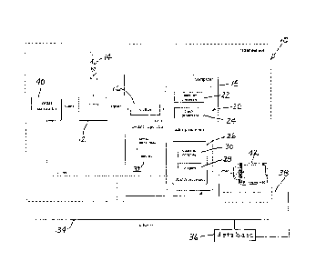
A block diagram of a radar sensor apparatus 10 in accordance with the present
invention is
shown in Figure I. Characteristics of each block are as follows. 'Fite radar
sensor apparatus
10 includes a radar device 12 that is typically noncoherent and transmits
pulses of constant
width at a constant pulse repetition frequency (PRF) at X-band or S-Band.
Radar device 12
typically has either a continuously rotating or sector scanning antenna 14.
Antenna 14 is
elevated to be several meters above the area to be monitored, and has a
detection range of
several kilometers. COTS marine radars typically have these characteristics
and are preferred
for the present invention due to their availability, low-cost, and good
antenna and transceiver
characteristics.
Radar device 12 takes the form of a marine radar. A typical marine radar is
noncoherent.
transmits at X-band with 50 kW peak power, pulse repetition frequency (PR.F)
between I and
2 kHz and with pulse width between 0.1 and 1 tts. It has a 2 m antenna with a
narrow
azimuth beamwidth and a wide elevation beamwidth, rotates at 24 RPM. and has
up to 165
CA 02898390 2015-07-27
km range. A radar such as this retails for around $50,000. Marine radar
configurations are
based on choosing a peak power/maximum-range value and an antenna size. Radars
with
peak powers up to 10 kW typically retail for less than $10,000. The lower-
power radars can
be purchased for as little as two or three thousand dollars making them very
cost effective.
5
In some applications, it is important to use a specialized antenna 14 to meet
requirements. An
avian radar application, for example, often requires bird height information.
A typical marine
radar antenna with a 20' elevation beamwidth does not provide accurate enough
height
estimates in these cases. As a result, other antennas may be preferred. In the
article [Nohara,
10 1 3 et al, Affordable avian radar surveillance systems for natural
resource management and
BASH applications, 2005 IEEE International Radar Conference, May 9-12, 2005,
Arlington,
VA], a 4 pencil beam dish antenna is described that has been successfully
tested in the field
with an implementation of the radar sensor of the present invention. This
antenna provides
better height estimates of birds but its coverage is limited. To solve the
coverage problem,
antenna 14 may be an elevation-monopulse antenna to provide simultaneously
good height
estimates with full coverage in elevation. The present invention provides for
the integration
of such an antenna into the radar sensor apparatus 10. While a phased array
antenna could be
integrated into the radar sensor 10 of the present invention, it is not a
preferred embodiment of
the present invention due to the significantly higher cost anticipated for
such an antenna. In
addition, it is not clear that the volume search rate of such a two-
dimensional antenna could
satisfy target update requirements.
As illustrated in Figure I, a digitizer 16 is connected to an output of marine
radar device 12
for collecting radar video samples from each pulse, at sampling rates and over
range intervals
appropriate for the operational mode. Digitizer 16 is preferably a PC card
mounted on a bus
of a computer 18, which is preferably a commercial off-the-shelf (COTS) PC.
The PC
computer 18 can run any standard operating system, but preferably runs a
Microsoft
WindowsTm operating system. The digitizer 16 itself is preferably a COTS
product to further
reduce the radar sensor cost. The digitizer 16 preferably samples the radar
video signal at 12-
bits and operates in real-time. The digitized signals are the full-bandwidth,
unprocessed radar
CA 02898390 2015-07-27
signals captured in real-time to create a fully digital radar sensor in which
the radar's signal
processing and operating characteristics are determined bv a radar processor
20.
Radar processor 20 is implemented as generic digital processing circuits of
computer 18
modified by programming, or configured by software, to accomplish the
functions described
hereinafter. Radar processor 20 includes includes a detection processor or pit
extractor 22, a
multi-target track processor 24 and a display processor 26 all of which are
preferably
implemented in real-time by software that runs on the COTS PC 18. The software
is
preferably written in C/C++, and possibly assembly, and uses multi-threaded
programming to
provide a highly responsive application as well as for computational
efficiency. The software
also preferably exploits the Single Instruction Multiple Data (SINID)
capabilities of modern
processors to considerably improve processing speed.
I
Detection processor 22 declares the presence and location of targets
preferably on each radar
scan. Track processor 24 sorts the time-series of detections (also called
plots) into either
tracks (confirmed targets with estimated dynamics) or false alarms. The
processed
information produced by radar processor 20 can be presented to the operator on
a local
display 28 that is part of display processor 26. This information may include
scan-converted
video, target data including detection data and track data, maps, user data
(e.g. text, push pins)
etc. Operator controls 30 may be local as well and provide a graphical user
interface for the
local user to control the operation of the radar processor 20.
The radar processor 20 performs radar signal processing functions known to
those skilled in
the art such as scan-conversion, adaptive clutter-map processing to remove
ground and
weather clutter, sector blanking to suppress detections in regions that are
not of interest,
constant false alarm rate (CFAR) processing, and digital sensitivity time
control (STC).
These functions may be included in either the detection processor 22 or the
display processor
26, but preferably are included in both so that the user display can be
optimized for the user
while the detection processor can be optimized for detection and tracking
performance.
Conventional radars employing automatic detection and tracking algorithms
typically set the
detection threshold high enough to achieve a probability of Use alarm (PFA) to
1 in 106
CA 02898390 2015-07-27
12
resolution cells or less, For a radar display extending 50 km in range with a
100 m range
resolution and 10 azimuth resolution, this translates to about 1 false alarm
every 5 scans or 12
seconds (typical marine radar scan rates are 24 RPM). In contrast, low
detection thresholds
are a special feature of the detection processor 22 and are used in order to
increase the
sensitivity- of the radar, allowing smaller targets to be detected. An
unwanted side effect is
that the false alarm rate increases substantially, making it more difficult
for tracking to
perform. For example, the PFA could drop 3 orders of magnitude from typical
settings to say
10-3 resulting in 180 false alarms per scan or 72 false alarms per second.
This is a huge stress
on tracking. To
mitigate this effect, as veil as to successfully track through maneuvers
without degradations in track quality, the track processor 24 preferably
includes multiple
hypothesis testing (NWT) tracking with interacting multiple model (IMM)
extended Kalman
filtering as described earlier, and which are further described in [D.B.Reid,
"An algorithm for
tracking multiple targets", IEEE Transactions on Automatic Control, vol. AC-
24, no. 6, Dec.
1979, pp. 843-854 [G.A.Watson and W.D.Blair, "1MM algorithm for tracking
targets that
maneuver through coordinates turns", Proceedings of the SP1E (Society of Photo-
Optical
Instrumentation Engineers, vol. 1698, Signal and Data Processing of Small
Targets, April 20-
22, 1992, pp. 236-247]. These advanced processing algorithms often found in
military radars
yields the performance of much higher-priced systems and have been shown to
work well
under these high false alarm rate conditions.
The display processor 26 provides a real-time display. Preferably, a map is
integrated with
the radar display and provides a background on which is overlaid geo-
referenced radar data,
including target data (tracks and detections), target echo trails, as well as
scan-converted
radar video in the form of a PPI display. These features enable target
behavior to be more
easily understood, where the display processor 26 can be viewed as a
geographical
information system (GIS). Cursor position in latitude and longitude or UTM
coordinates is
continuously read out in the status bar, and numerous display features common
to marine
radars such as electronic bearing lines and virtual range markers are
available. Small
symbols at the location where the threshold is exceeded indicate detections. A
history of
detections from previous scans can be shown, with fading intensities
indicating scan time (the
current scan's detections are the brightest). Tracks are indicated by a
different symbol drawn
at a target's current position with a line emanating from the symbol
indicating the heading.
the operator can select any track on the screen, and the system will display
target
information such as position, speed. heading, track stage, track uncertainty,
echo size and
CA 02898390 2015-07-27
13
intensity. These target attributes can also be used tor the study and
classification of targets of
interest, and for multi-sensor fusion. Detection and track data are rich with
target attributes
that are available for viewing by the operator in real-time. At any instant in
time, the track
histories provide situational awareness of recent activity. Any suspicious
behavior (e.g.
perimeter crossings) can be recognized, and communicated to authorities.
Many of the aforementioned radar processor features as well as features not
mentioned above
are described in [Weber, P et al., Low-cost radar surveillance of inland
waterways for
homeland security applications, 2004 IEEE Radar Conference, April 26-29, 2004,
Philadelphia, PA and [Nohara, I .1 et al, Affordable avian radar surveillance
systems for
natural resource management and BASH applications, 2005 IEEE International
Radar
Conference. May 9-12, 2005, Arlington, VA]. For example, the benefits of the
low detection
thresholds to improve small target detection sensitivity are demonstrated with
real data in
[Weber. P et al., Low-cost radar surveillance of inland waterways for homeland
security
applications, 2004 IEEE Radar Conference, April 26-29, 2004, Philadelphia, PA
] along with
the ability of the track processor 24 to track reliably through target
maneuvers without
increasing track uncertainty. Clutter-map processing is demonstrated in
[Nohara, T ct al,
Affordable avian radar surveillance systems for natural resource management
and BASH
applications, 2005 IEEE International Radar Conference, May 9-12, 2005,
Arlington, VA] to
reject ground clutter so that birds can be detected along with a specialized
target echo trails
display mode that is a feature of the present invention.
A feature of the digital radar processor 20 of the present invention is the
implementation of
automated alerts based on target behavior inferred from track data. Target
behaviors such as
perimeter breach, collision prediction or any complex behavior can be defined.
When
operating as an automated monitoring system, security perimeters are
preferably defined. The
radar processor then determines when targets approach and cross these
perimeters, and issues
appropriate alert responses. Preferably, target detection, tracking and threat
recognition
algorithms are customized for speci.fic threats and scenarios. Alerts can
include an audible
alarm and display indication to an operator, or a transmitted message to a
remote user.
Transmitted messages are preferably communicated over a network to remote
users using
networking and communication methods and technology known to those skilled in
the art.
Preferably, alerts can be issued as text messages or e-mails directed to
pagers, cell phones,
personal data assistants. BlackberrvsTM etc. using COTS technology. Alerts
can
CA 02898390 2015-07-27
14
minimize required operator resources even to the point of permitting some
systems to run
24/7 unattended.
A recorder 32 shown in Figure I can store the received radar video samples
onto disk or tape.
Target data including track data and detection data can also be recorded,
Target data is a
more compact and convenient alternative to raw radar video and can easily be
stored
continuously, 24/7, without stressing the storage capacity of a COTS PC. These
same data
can be remoted over a network 34; full-fidelity raw video, however, generally
requires very
high-speed networks. Target data, on the other hand, can be handled on low-
speed networks,
including real-time distribution over COTS wireless networks and over the
Internet through
inexpensive COTS networking hardware. The stored data (in either raw format or
target data
format) can subsequently be played back through any computer running the radar
processor
software; it is not necessary that it be connected to a radar. This feature is
useful for oft-line
analysis, investigations, evidence for use in prosecutions, etc. Target data
can be archived for
longer-term investigations. The recorder 32 stores target data in accordance
with operator
selections. The recorder 32 supports continuous writing of target data
directly to a database
36 (as well as to other tile formats). The database 36 can reside locally on
the radar processor
computer, as indicated by a phantom connection 38, on another computer on the
network, or
on both. The database 36 is used preferably for post processing, for
interaction with external
geographical information systems (GIS) systems, for remote radar displays, for
support for
web services, and for further research and development (e.g. to investigate
and develop target
identification algorithms).
Another feature of the radar processor 20 is that it can he controlled
remotely over network 34
(schematically shown as a bus in Figure 1), when a network connection is
available. Radar
processor control functions are implemented preferably as a web service, or
alternatively, by
using a virtual network console (VNC) so that the PC keyboard (not shown) and
display 28 of
radar processor 20 can be run remotely. COTS VNC server software runs on the
radar
processor PC and client VNC software runs on the remote end of the network 34.
If the
network 34 includes one or more segments on the Internet, a virtual private
network (V FN) is
preferably established using COTS technology known to those skilled in the
art. In this
manner, the radar processor 20 can be remotely controlled from anywhere on an
established
network, using COTS software and hardware.
CA 02898390 2015-07-27
If the radar processor 20 is to be controlled remotely over the network 34, it
becomes
important to also be able to control remotely the marine radar functions as
well. These
functions include, preferably, power-on/off, transmit/standby, and operating
range selection.
Unfortunately, COTS marine radars designed for marine use do not come with
network-
5 enabled remote control features. As a result, a feature of the radar
sensor of the present
invention is a radar controller 40 to control the marine radar through a
network-enabled
software interface. The radar controller 40 includes hardware (e.g. switches,
control codes,
etc.) that integrates with the marine radar to provide thereto external
control signals that
replicate internal control signals of a built-in controller of the COTS marine
radar device 12,
10 as provided by the radar manufacturer. This hardware is controllable by
software that
preferably runs on a COTS PC, and may be the same COTS PC that houses the
radar
processor. The software provides either a user interface or programmer's
interface to control
the aforementioned radar features. The software can be accessed over a network
(as
illustrated in Figure 1) either as a web service or through a VNC connection
as described
15 earlier.
Marine radars typically remember their state during power down. Therefore,
when the radar
is powered up, it comes back in its previous state (which includes the range
setting). If the
marine radar is to be controlled remotely, then it is important that the
operator is certain of the
state of the radar at all times since the radar processor performance depends
on this. A novel
feature of the radar controller 40 is its preferred use of the radar's own
display 28 to confirm
the radar state. The radar's local display video, schematically represented at
42, is captured
preferably using COTS frame-grabber technology and made accessible remotely
through the
radar controller software. In this way, the remote user can use the software
to change the
radar's state and can confirm immediately that the state has changed as
requested by
observing the remoted radar display. In Figure 2, a block diagram of the radar
controller 40 is
shown. The diagram shows two logical components, namely the radar controller
40 with
interface 44, and the marine radar device 12. The radar controller 40 is
ideally composed of
both COTS hardware and software with the addition of original hardware and
software.
Controller 40 utilizes a hardware and software interface customized for the
particular radar
type to be controlled. Where possible, the existing radar control is preserved
so that the
addition of the computer automation does not interfere with standard manual
operation of the
radar system. Within the interface 44, the controller is connected to a power
switch or relay
46 for enabling remote control of the power supply to radar device 12, and to
a command
CA 02898390 2015-07-27
16
combiner 48 for controlling data transmission functions and antenna range. As
shown in
Figure 2, radar controller 40 is connected to an input of command combiner 48,
while non-
automated or manual radar controls of marine radar device 12, 18 are connected
to another
input of the command combiner. Command combiner is connected at an output to a
command
input of marine radar device 12, 18 to alternatively provide thereto the
external control signal
from radar controller 40 and at least one signal from the non-automated or
manual radar
controls of the marine radar device. The interface 44 thereby connects radar
controller 40 to
marine radar device 12, 18 in parallel with the non-automated or manual radar
controls
thereof. The interface 44 also includes a video splitter 50 and a video
capture module 52 for
capturing the radar's local display video 42.
Figure 3 shows a preferred implementation 54 of the radar controller 40 of
Figure 2 as applied
specifically to a COTS Furuno 2155E313 radar system 56. The controller 54 uses
serial codes
for a variety of functions and relay contact switches for other functions. The
emulation of
other radar control functions may require the use of digital to analogue (DIA)
converters,
analog to digital (A/D) converters, digital 1/0 or other conversion interfaces
in order to enable
computer control. The combination of hardware interfaces and software
application interface
are then network-enabled using standard open web services such as XML Remote
Procedure
Calls (XML-RPC) or SOAP over a standard network transport protocol, such as
FIVIT.
-)0
Components of the COTS Furuno 2155813 radar system 56 in Figure 3 that perform
the same
functions as components shown in Figures I and 2 are labeled with like
reference
designations. Figure 3 also depicts a Furuno processor 57, a Furuno keyboard
58 and an
ancillary radar processor 60.
One or more radar sensor apparatuses 10 as described above with reference to
Figures 1-3 can
be connected to network 34 to distribute information to remote users. The
radar processor
architecture supports real-time communication of target data to remote sites
using low-
bandwidth, COTS network technology (wired or wireless). Since the target data
contain all of
the important target information (date, time, position, dynamics, plot size,
intensity, etc.),
remote situational awareness is easily realized. The all-digital architecture
facilitates
networking of radar target data and control functions to a central monitoring
station (CMS) 60
(Figure 4) to consolidate monitoring resources for an entire radar network,
thereby
minimizing operating cost and providing for low-cost, high-performance radar
networks. The
CA 02898390 2015-07-27
17
use of open network protocols such as TCP/IP and FITIP allow the delivery of
the radar data
anywhere over the Internet. It also makes available a number of standard web
service
protocols that can be used on the network to provide a software application
programmintz
interface (API). One example of this is the use of XML-RPC in the radar
controller 40, 54 to
create a network-enabled API that is accessible over HIT P. A web server is
then used to
provide a client interface to a remote user. The web server functions as both
a web client
application to the XML-RPC server to perform the radar control functions, as
well as a web
server application to provide a user-friendly graphical interface to a remote
user with a client
web browser. This same principle is applied to other radar data services, such
as the web
services server interface to a TCP/IP networked SQL database containing a
repository of past
and live real-time radar data.
Figure 4 shows a conceptual diagram of the computer radar network 34. One or
more radar
sensors 10 send their target data to one or more CMS 60 (which could be co-
located with any
of the radar sensors 10). The target data consists of detection data, track
data and/or alerts.
Raw radar video data could also be sent to the CMS 60 in real-time if a
suitable network was
available, but preferably, target data is sent. Other types of surveillance
sensors (e.g. sonar)
can also be on the network 34. The network 34 and its software are typically
COTS. The
CMS 60 has a fusion/display processor 62 (Figure 5) that processes, combines,
displays and
archives the data. Integrated tactical information, including displays and
alerts, is provided.
Track and detection data from the separated radar sensors 10 may be fused to
take advantage
of their spatial diversity and improve the radar network performance beyond
that of the radar
sensors themselves using multi-sensor data fusion methods known to those
skilled in the art.
This takes advantage of the spatial diversity of the sensors, and improves the
radar network
performance beyond that of the radar sensors 10 themselves. Data can also be
accessed and
integrated from other private or public networks (e.g. military, NEXRA D) as
well.
Figure 5 shows a preferred embodiment where the radar network 34 is
implemented via the
global computer network 64 known as the "Internet", with only a single radar
apparatus 10
shown. The same configuration of radar processor 20 plus radar controller 40
(or 54) is
replicated for other sites. Each site is connected to the Internet network 64
using a firewall
and router device 66. (It is not necessary to use the Internet 64 as part of
the network; a
completely dedicated or private network could obviously be used as %yell.)
This configuration
enables each independent site to connect and send radar data continuously and
in a real-time
CA 02898390 2015-07-27
18
fashion to a remote radar data server 68 and to enter it into a common SQL
database server.
A single SQL database server is capable of receiving radar data from multiple
related Radar
Processor sites simultaneously. The centralized pooling of radar data from the
multiple radar
sites allows for integration or fusion of related radar data by the CMS
Fusion/Display
processor 62. An example of this is the processing of radar target tracks that
cross the radar
coverage area scanned by the radar antenna 14 of physically adjacent or
related radar sensors
10.
The use of a standard open high-performance networked SQL database server in
the radar
data server 68 further maximizes the flexibility in providing the data
services to multiple
CMS users on the network 34 while keeping costs low. The asynchronous
messaging within
the SQL database allows the radar processor 20 to indicate when a new scan of
data is
available inside the database. This signals the fusion/display processor 62 of
any CMS 60 to
monitor a particular radar processor 20 to update its display in real-time
with the latest data.
The CMS fusion/display processor 62 need not be local to the radar data server
68 and may be
located anywhere on the network 34, whether realized via the Internet 64 or a
private network
(not separately illustrated). In addition to monitoring live radar data, the
CMS 60 also
provides the capability to play back past recorded radar data. The
functionality is analogous
to that of a COTS hard-disk based Personal Video Recorders (PVR) such as TiVO.
The CMS
60 may similarly allow a user to:
= choose to watch a particular live radar data feed coming from a single or
multiple
radar processors 20, with Picture-In-Picture type monitoring,
= pause the display,
= continue the display (now delayed from live by the pause time),
= rewind or fast-forward through the data with display at 2x, 4x, or 8x rates,
= play back at 1/8x, 1/4x, 1/2x, lx (real-time), 2. 4x, or 8x speed,
= play back data from a particular time stamp or index marker,
= choose another pre-recorded experiment from menu, and
= resume mom luring of the live data feed.
A handheld remote control device similar to that of a PVR, VCR, or DVD player
preferably
provides the operator with a familiar human device interface. Such high-
performance features
added to a radar network as described above are unique to the present
invention, all at
affordable cost by exploiting open and COTS technologies.
CA 02898390 2015-07-27
19
The network-enabled XIVIL-RPC API of the radar controller 40 (or 54) gives
programmatic
access to the radar by an engineering maintenance console 70 (Figure 5).
Operations across
multiple sites may be scheduled ahead of time and executed remotely by
software. An
example of this is the scheduling of monitorimz only during a nightly
interval. Another
example is the automated change of radar parameters during daytime monitoring.
In a similar manner to the use of sophisticated radar processing and tracking,
the CMS
fusion/display processor 62 shown in Figure 5 can fuse target data from a
radar network 34 to
enhance the performance of these noncoherent low-cost radar systems, and have
them
approach the level of more expensive coherent radar systems. Some of the
performance
improvements achievable through integration and fusion of data from radar
networks include
but are not limited to the following:
= Multi-radar fusion to improve track accuracy, continuity, quality, etc.
= Spatial diversity against target fluctuations in RCS (necessary for small
targets)
= Spatial diversity for shadowing due to geographic obstructions
= Spatial diversity to cover extended borders, equivalently increasing
radar coverage
The richness of the target data available from each radar sensor apparatus 10
in the network
allows much flexibility when such data is required to be combined or fused for
a wide-area
display. Depending on the level of fusion required (which will be driven by
application,
geography and target density.), the target data permits both contact
(detection) and track-level
combination of data. The following (non-exhaustive) list provides some
examples of possible
fusion methods that may be applied to the available data:
= Synchronous fusion (contact-level)
2.5 = Parallel fusion (contact-level)
= Best track (track-level)
= Covariance intersection (track-level)
= Information fusion (track-level)
= Reasoning and knowledge-based approaches
As is known to those skilled in the art, numerous methodologies and algorithms
exist for
combining such data, and new techniques are always being developed. The
following
references provide examples of such methods [DI. Ilan, J. Llinas (Eds),
Handbook of
Multisensor Data Fusion, CRC Press, 2001], 1Y. Bar-Shalom (Ed.). Multitarget-
Multisensor
CA 02898390 2015-07-27
7)0
Tracking: Advanced Applications, Vol. 1õAstech House/YES Publishing, 19981 and
[DL.
Hall, Mathematical Techniques in Muitisensor Data Fusion, Artech House,
Norwood MA,
1992.] The sophistication of the aforementioned radar detection and track
processing, as well
as the careful archiving and transmission of this data. ensures that the CMS
fusion/display
processor 62 can incorporate and evaluate any applicable fusion strategy,
including new and
emerging methods. Another significant feature of the present radar
surveillance system is the
ability to customize the level and extent of the integration and fusion
available, which is
achievable through the rich information that has been produced and recorded by
the radar
detection processor 22 and tracker processor 24.
Figure 6 illustrates an example of a radar network 34 in accordance with
principles elucidated
herein. Seven radar sensors 10 schematically depicted as antennas 14 are
assumed to be
geographically separated to cover a wide-area of surveillance. Land-based
installations are
assumed, and antenna towers are made high enough to reduce blockage to
acceptable levels,
hut low enough to be cost-effective and covert. Portable and mobile systems
are also
possible. In this example, two CMS's 60 are shown, one indicated as a command
and control
CMS 60a and the other as a secondary operations center 60h. Ten radar
workstations 72 are
shown in the one CMS 60a and a single radar workstation 74 in the other 60b.
Each radar
workstation 72. 74 can run the CMS fusion/display processor to create an
integrated tactical
surveillance picture from target data associated with a particular radar
sensor 10, or multiple
radar sensors. These support multiple operators with specific missions. A
dedicated display
processor 76 that provides a completely integrated tactical picture preferably
using all of the
available radar sensors 10 drives a large war-room type display. Each radar
workstation 72,
74 is a dedicated workstation or workstations 72, 74 could also serve as the
engineering
maintenance console 70.
Another novel feature of the present radar surveillance system is the
provision of a remote
integrated tactical display to a mobile user. For example, consider the case
where law
enforcement personnel are attempting to thwart an illegal activity in a border
patrol
application. The law enforcement personnel are located on mobile vessels on
the water
border. Using their on-board marine radar provides little or no situational
awareness for
reasons described earlier. Furthermore, line of sight is extremely' limited
because of the low
height of the marine radar above the water. Instead, the law entbrcement
vessel receives an
integrated tactical picture from the CMS 60 over a wireless network 34. The
law enforcement
CA 02898390 2015-07-27
21
vessel has an on-board COTS PC running a remote CMS Display Client that
provides the
integrated tactical picture created by the CMS Fusion/Display Processor.
Preferably. the
vessel's current location is shown on the tactical picture via a GPS input.
The CMS 60 (or
60a, 60b) simply routes fused target data produced by the CMS fusion/display
processor 62
over a wireless network 34 to the CMS Display Client. The law enforcement
vessel gains the
benefit of the performance of the entire radar network. Even if only a single
radar sensor 10
is available and the radar processor 20 remotes its target data to the CMS
display client
directly, the vessel will have the radar visibility of a land-based, tower-
mounted marine radar
and sophisticated processing that far exceed the capabilities of the on-board
marine radar.
I 0
Sighting land-based radar sensors to maximize coverage is an important factor
in network
design and resulting radar network system performance. Sighting a radar for
coverage can be
a labor intensive and hence expensive process. In accordance with another
feature of the
radar processor of the present invention, this labor cost is minimized. The
display processor
26 includes the ability to overlay PPI radar video (with now ground clutter
suppression) on
top of a geo-referenced map. Since the radar sensors 10 are land-based, this
overlay will
immediately show the presence of ground clutter, or its absence due to
blockage or
shadowing. Wherever ground clutter is present and overlaid on the map,
coverage is available,
where ever it is not, coverage is not available (at least for targets low to
the ground). Moving
the radar around in a mobile vehicle (e.g. a truck with a telescopic mast) and
creating these
coverage maps in real-time is a convenient, efficient, and cost-effective way
of sighting the
radar sensors that will form a radar network.
One of the key features of the present radar surveillance system is the
exploitation of COTS
technologies to keep the radar sensors and radar network low-cost. Not only is
initial
purchase cost made affordable with this approach, but maintenance and
replacement are also
characterized by short lead times, multiple suppliers, and reasonable prices.
The systems in
accordance with the present invention deliver high performance with features
tailored to
customer needs while minimizing the three major components of cost: purchase
cost,
maintenance cost and operational cost.
A final feature of the present radar surveillance system is its software re-
contigurability which
permits extensive customization to adapt its features to specific applications
other than those
described herein, with reasonable levels of effort. This will permit access to
smaller markets
CA 02898390 2015-07-27
27
since minimum economic quantities of customized systems will be small. The
software
platform architecture also permits upgrades, feature addition, and target
market customization.
Particular features of our invention have been described herein. The scope of
the claims
should not be limited by the preferred embodiments set forth in the examples,
but should be
given the broadest interpretation consistent with the description as a whole.