Note : Les descriptions sont présentées dans la langue officielle dans laquelle elles ont été soumises.
CA 02924151 2016-03-11
SYSTEM FOR DETECTING AND LOCATING SUBMERGED OBJECTS
HAVING NEUTRAL BUOYANCY SUCH AS MOORED MINES AND
ASSOCIATED METHOD
The invention disclosed herein relates to a system
for detecting and locating underwater objects having
neutral buoyancy, comprising a sonar making it possible
to detect the underwater objects having returned sonar
echoes, that is to say returned echoes following the
emission of an acoustic pulse (or acoustic ping) by the
sonar.
Moored mines are mines of neutral buoyancy being
attached by a cable, called tether, to an anchor,
called sinker, resting on the seabed. The sonars are
mounted either on a surface ship, or on a fish towed by
a surface ship or on a self-propelled underwater
vehicle.
One of the problems in detecting objects having
neutral buoyancy is being able to detect mines over a
wide swath so as to monitor an area of the marine
environment that is as wide as possible in a minimum
time. Another problem is being able to locate the
detected mines with a sufficiently great accuracy in
the three dimensions of space. In other words, another
problem is producing a system for detecting underwater
objects that exhibits a sufficient locating accuracy in
the three dimensions of space of the order of a few
meters.
One existing solution consists in using front
looking sonars which insonify the water column in front
of the carrier and which form a plurality of contiguous
directional beams in reception terms. One drawback with
this solution is that, to cover a wide swath at right
angles to the axis of the carrier and locate
C.A0241_5120161
- 2 -
underwater targets having neutral buoyancy with a good
accuracy in terms of relative bearing, arrays that are
of large dimensions, are bulky and consume a lot of
electrical energy are needed. This drawback is
incompatible with the trend in mine warfare which is to
distance man from the threat. Technical solutions are
sought for mounting the sonars on autonomous carriers,
on board which a limited energy is stored, rather than
on ships of mine hunter type. Another drawback with
front looking sonars is that they do not make it
possible to locate the mines with a good accuracy in
terms of elevation without an array that is directional
in elevation and which therefore adds bulk and energy
consumption.
Another solution is described in patent
application US5506812; it consists in using cylindrical
emission and reception arrays that make it possible to
insonify a toroidal zone surrounding the carrier in a
single acoustic ping, that is to say a single acoustic
pulse. This solution presents the drawbacks of
requiring a high emission power to transmit an acoustic
pulse over 360 and of being very bulky since it uses
an array with 120 reception channels. Moreover, the
processing of the multiple reception channels to detect
objects in the water column and locate them can prove
complex.
The aim of the invention is to remedy at least one
of the abovemetioned drawbacks.
To this end, the subject of the invention is a
system for detecting and locating submerged underwater
objects having neutral buoyancy, comprising at least
one mechanically steered sonar with a single channel,
the mechanically steered sonar being a sonar with a
single emission channel making it possible to perform
C.A0241_5120161
- 3 -
the insonification of a first individual sector in a
first pointing direction by means of a single first
pulse and forming a single reception channel suitable
for acquiring a first acoustic signal resulting from
said insonification, the mechanically steered sonar
being mounted on a carrier intended to advance in a
main direction, such that the first pointing direction
is substantially lateral to the carrier and that the
first Individual sector exhibits a wide relative
bearing aperture and a narrower elevation aperture, the
scanning sonar comprising a pointing device intended to
tilt the pointing direction about an axis of rotation
substantially parallel to the main direction allowing
the sonar to acquire first acoustic signals resulting
from insonifications performed in different pointing
directions. The system according to the invention
advantageously comprises a processing unit configured
to locate underwater objects having neutral buoyancy
from first acoustic signals.
This system based on a mechanically steered sonar
offers the advantage of being inexpensive, small and a
low energy consumer compared to a multi-beam sonar
(with a plurality of reception channels) which would
require a powerful and bulky transmitter and a probably
curved reception array with at least fifty or so
channels. It also makes it possible, by configuring it
shrewdly and by shrewd processing operations, to detect
marine objects and locate them with a good accuracy in
the three dimensions of space of the order of that
obtained by means of a side-scan sonar for the
detection of underwater objects placed on the seabed.
It notably makes it possible to obtain position
measurements exhibiting a good location accuracy in the
three dimensions from a sonar having a poor horizontal
C.A0241_5120161
- 4 -
resolution since it is a sonar with a single emission
and reception channel exhibiting a poor resolution in
relative bearing terms.
This system also makes it possible to detect short
moored mines (situated at a low height relative to the
seabed) which are difficult to detect with a side-scan
sonar, particularly in proximity to the maximum
observation range.
Advantageously, the system comprises a processing
unit configured to locate underwater objects having
neutral buoyancy from at least one first acoustic
signal.
In a particular embodiment, the system comprises a
plurality of mechanically steered sonars spaced apart
in the main direction and the oriented pointing
directions of which are directed toward the same side
of a vertical plane passing through the main direction.
Advantageously, the system comprises at least one
side-scan sonar intended to image the seabed in a
second pointing direction in a second individual sector
exhibiting a wide relative bearing aperture and a
narrow elevation aperture, the side-scan sonar forming
a plurality of relative bearing reception channels and
being mounted on the carrier such that the second
pointing direction is oriented substantially laterally
to the carrier on the same side of the carrier, in
relation to the vertical plane passing through the main
direction, as the first pointing direction, the system
further comprising a human-machine interface comprising
a display device intended to simultaneously display a
first sonar image representing first acoustic signals
and a second sonar image representing second acoustic
signals acquired during a same period of acquisition by
the mechanically steered sonar and respectively by the
C.A0241_5120161
- 5 -
side-scan sonar with the human-machine interface being
configured such that, when the first and second images
are displayed simultaneously, an operator can, when
they visually identify, on the first image, a first
echo created by a submerged object having neutral
buoyancy, visually identify instantaneously, on the
second image, if a second echo has been reflected by an
object placed on the seabed substantially directly
below the submerged object.
This feature allows an operator to classify the
detected underwater objects and notably classify them
according to whether they are moored mines or free
objects having neutral buoyancy. In effect, both the
mine and the sinker return intense echoes which are
represented by bright zones on the sonar images. If, at
the moment when a first bright echo is obtained by
means of the scanning sonar, a second bright echo is
also obtained by means of the side-scan sonar around
the position of the first echo, there is a high
probability that this second echo has been formed by a
sinker and that the first echo has been formed by a
moored mine. This allows an operator to confirm a
detection of a moored mine in the volume. It is thus
possible to distinguish moored mines from free objects
such as shoals of fishes or mammals.
In a particular embodiment, the display device is
configured such that the first image and the second
image displayed have substantially identical sizes and
such that an echo included in the first image and an
echo included in the second image reflected by
respective objects situated at a same distance from the
mechanically steered sonar and respectively from the
side-scan sonar and generated following a first and a
second simultaneous insonification step are represented
C.A0241_5120161
- 6 -
substantially at a same abscissa and at a same ordinate
on the first image and on the second image.
In a preferred embodiment, the human-machine
interface comprises tracking means allowing an operator
to simultaneously move two cursors displayed by the
display device, one on the first image and the other on
the second image, the display device being configured
such that the two cursors occupy, on the first and the
second image, positions corresponding to a same
geographic position in a terrestrial reference frame.
Advantageously, the cursor displayed on the first
image is provided with a curve representing a set of
the possible positions on the first image of echoes
originating from an object having created an echo
represented at the position pointed to by the cursor.
Advantageously, which the first image and the
second image represent the first and second acoustic
signals in instant mode of emission of the acoustic
pulse originating the signals/distance separating, in
the horizontal plane, the objects originating the
echoes, and being included in said signals, from a
fixed point in relation to said sonars.
Advantageously, the system comprises a processing
unit suitable for identifying, in first signals, first
effective echoes effectively created by effectively
submerged effective objects having neutral buoyancy,
the display device being configured so as to display,
superimposed with the first image and/or the second
image, symbols at the effective positions considered as
being effectively occupied by the effective objects.
Advantageously, said human-machine interface
comprises a classification unit configured so as to
allow an operator to classify first echoes visible on
the first image or first effective echoes identified,
C.A0241_5120161
- 7 -
by a processing unit in first signals, as being created
by effectively submerged effective objects having
neutral buoyancy visible in a first class taken from a
plurality of classes comprising a moored mine class and
a free floating object class.
The invention relates also to a method for
detecting and locating underwater objects having
neutral buoyancy, using a system according to the
invention, the method comprising a scanning step in
which the mechanically steered sonar scans, a plurality
of times, a sector to be imaged open in a plane
substantially at right angles to the main direction, in
which the mechanically steered sonar performs
successive sonar acquisition steps in which the
pointing device points the first pointing direction in
successive pointed directions included in the sector to
be imaged, and, for each pointed direction, transmits a
first acoustic pulse at a first insonification instant
and acquires a first acoustic signal resulting from the
first acoustic pulse.
Advantageously, the method comprises a detection
step for detecting first potential echoes created by
submerged objects having neutral buoyancy by means of
first signals, comprising unitary detection steps, each
unitary detection step comprising an identification
step for identifying first potential echoes, considered
as having been created by respective potential floating
objects in response to a first acoustic pulse, the
first potential echoes being parts of first signals
satisfying a predetermined selection criterion.
Advantageously, the identification step comprises
a step of thresholding of the contrasts of first
signals.
C.A0241_5120161
- 8 -
Advantageously, the mechanically steered sonar is
configured, given the speed of the carrier, so as to
acquire, in the scanning step, more than once, echoes
from a one-off object fixed in the terrestrial
reference frame and located at a depth lying between a
predetermined minimum depth and a predetermined maximum
depth, and located at right angles to the main
direction in a horizontal plane, at a distance from the
mechanically steered sonar greater than a predetermined
minimum range and less than a predetermined maximum
range, the method comprising a step of locating
effective submerged objects having neutral buoyancy
from the first acoustic signals acquired in the
scanning step and from the first potential echoes.
Advantageously, the method comprises a step of
locating submerged objects having neutral buoyancy,
comprising:
a step of determination of potential positions of
the potential floating objects comprising, for
each first potential echo, a step of determination
of a set of potential positions, that the
corresponding potential object is likely to
occupy, from the position of the sonar at the
first instant of emission of the first acoustic
pulse originating the first potential echo,
an accumulation step in which positions that are
fixed in the terrestrial reference frame are
assigned respective probabilities of occupancy
corresponding to probabilities of being actually
occupied by an object, said respective
probabilities of occupancy being initialized at
the start of the accumulation step and incremented
each time the respective fixed positions are
C.A0241_5120161
- 9 -
determined as being potential positions in the
step of determination of potential positions,
a step of identification of effective positions
effectively occupied by effective submerged
objects having neutral buoyancy from fixed
positions assigned a probability of occupancy
above a predetermined threshold.
Advantageously, the set of potential positions of
a potential object is a circular arc, of radius equal
to the distance separating the potential object from
the mechanically steered sonar computed from the
difference between the first instant of emission and
the instant of reception of the first potential echo
created by the potential object, the center of which is
the position of the sonar at the first instant of
emission and the aperture of which is equal to the
aperture of the first individual sector, the first
individual sector corresponding to the sector in which
is transmitted the portion of the main lobe of the
first acoustic pulse attenuated to the maximum of 3dB,
or equal to the aperture of the first individual sector
plus a predetermined tolerance aperture.
Advantageously, the method is implemented by means
of a system according to the invention, comprising a
step of imaging of the seabed concurrent with the
scanning step, the step of imaging of the seabed
consisting in imaging the seabed by means of the side-
scan sonar by transmitting second successive acoustic
pulses at second successive insonification instants,
and by conducting the acquisition of the second
successive acoustic signals deriving from the second
successive pulses, the method further comprising a step
of simultaneous display of a first image representing
first acoustic signals and of a second image
C.A0241_5120161
- 10 -
representing second acoustic signals acquired during a
same period of acquisition by the mechanically steered
sonar and respectively by the side-scan sonar.
Advantageously, the method comprises a step of
classification, by an operator by means of a
classification unit, of at least one first echo visible
on the first image in a class taken from a plurality of
classes comprising a moored mine class and a free
floating object class.
The invention relates also to a system for
detecting and locating submerged underwater objects
having neutral buoyancy suitable for implementing the
method according to the invention, comprising a
processing unit configured so as to implement the step
of identification of the first potential echoes.
Advantageously, the system comprises a positioning
unit, such as an inertial navigation system, configured
so as to determine the position of the carrier as a
function of time, in which the processing unit is
configured so as to implement the location step, the
positioning unit or the processing unit being
configured so as to determine the position of the
mechanically steered sonar.
Other features and advantages of the invention
will become apparent on reading the following detailed
description, given as a nonlimiting example and with
reference to the attached drawings in which:
- figure 1 schematically represents, in
side view, a carrier equipped
with elements of a detection
system according to the
invention, the equipment items
represented in broken lines
are equipment items installed
CA0292415120161
- 11 -
inside the carrier, and remote
equipment items are also
represented in this figure,
- figure 2 schematically represents, in
plan view, a carrier equipped
with elements of a detection
system according to the
invention,
- figure 3 schematically represents
a
transverse cross section of a
carrier equipped with elements
of a detection system
according to the invention,
- figure 4 represents a flow diagram of
the method according to the
invention,
- figure 5 represents, on the
same
transverse Cross section,
successive pointed directions
of the scanning step,
- figure 6 schematically represents the
limits of a zone of the marine
environment imaged by the
mechanically steered sonar,
- figure 7 schematically represents
potential positions occupied
by objects creating first
echoes received by the
mechanically steered sonar in
two imaging steps according to
pointed directions exhibiting
a same elevation angle,
- figure 8 schematically
represents
potential positions occupied
C.A0241_5120161
- 12 -
by the first individual sector
in successive imaging steps
separated by a scanning period
according to pointed
directions exhibiting a same
elevation angle,
- figure 9 schematically represents an
exemplary display according to
the invention of the
representations of first
echoes and of second echoes
received by the mechanically
steered sonar and respectively
by the side-scan sonar.
From one figure to another, the same elements are
identified by the same references.
Figure 1 shows elements of a system for detecting
underwater objects according to the invention.
The detection system comprises an imaging system
comprising a first sonar 2, called mechanically steered
sonar, intended to image the water column. This
mechanically steered sonar 2 is mounted on a carrier 1.
The carrier 1 can be a ship, a towed or autonomous
underwater vessel. It is intended to advance in a main
direction of advance D considered as being
substantially horizontal. The direction D is an
oriented direction. The main direction D is the
longitudinal direction of the carrier 1 and is oriented
toward the front of the carrier. The carrier 1
advantageously comprises stabilizers, such as rudders
that are not represented, making it possible to keep
the bank angle of the carrier constant (that is to say
to limit the roll) and possibly limit the yaw and pitch
such that the depth of the sonar or of the sonars
C.A0241_5120161
- 13 -
embedded on board the carrier is constant with constant
depth of the carrier when the direction of advance is
substantially horizontal in the terrestrial reference
frame.
The mechanically steered sonar 2 is a sonar with a
single transmit channel and a single reception channel.
It is mounted on one of the flanks of the carrier 1. As
can be seen in figure 2, the detection system
advantageously comprises two mechanically steered
sonars 2, 2' mounted on the respective flanks la, lb of
the carrier 1. Only the sonar 2 will be described in
the patent application, the other sonar 2' being
configured and arranged in the same way.
The mechanically steered sonar 2 is intended to
conduct a sonar acquisition of a first individual
sector SE1 by transmitting a single first acoustic
pulse and by conducting the acquisition of the first
acoustic signals thus obtained. The first individual
sector SE1 is the sector at -3dB in which is emitted
the main lobe of an acoustic pulse emitted by the sonar
2. A first oriented pointing direction PA1 is defined,
visible in figure 2, corresponding to the direction in
which the maximum acoustic energy is sent when the
sonar transmits a first acoustic pulse. The
mechanically steered sonar 2 is mounted on the carrier
1 such that the first pointing direction PA1 is
substantially lateral to the carrier 1. In other words,
the first pointing direction PA1 extends in a
substantially vertical plane forming, in a horizontal
plane in the terrestrial reference frame, a non-zero
angle with the main direction D. This plane is
advantageously substantially at right angles to the
main direction D. The mechanically steered sonar 2 is
also mounted on the carrier 1 such that the first
CA 029241512015-09-11
- 14 -
individual sector SE1 exhibits a wide relative bearing
aperture 20311 (in the horizontal plane) and a narrow
elevation aperture 203v (in the vertical plane), visible
in figure 3, so as to obtain the desired angular
resolution according to the elevation. The narrow
elevation aperture makes it possible to limit the
effect of reverberation from the surface of the water
and locate the objects having neutral buoyancy with a
good accuracy. The first pointing direction PA1 divides
the first individual sector SE1 into two equal parts in
these two planes.
The mechanically steered sonar 2 comprises a
mechanical pointing device 3 intended to tilt the first
pointing direction PA1 about an axis of rotation x
substantially parallel to the main direction D. In
other words, the pointing device 3 allows the sonar 1
to perform a vertical scan. This device is, for
example, a device that makes it possible to tilt the
emission and reception arrays of the sonar about the
axis x. In other words, it mechanically tilts the
pointing direction about the axis x.
The system according to the invention
advantageously comprises a processing unit 5 making it
possible to locate and possibly detect, prior to the
locating, underwater objects having neutral buoyancy
from at least one first acoustic signal.
The mechanically steered sonar 2 is not bulky, and
a low electrical energy consumer. Moreover, the first
acoustic signals obtained by means of this sonar are
easy to process notably to proceed to detect underwater
objects, and locate them. It makes it possible, by
configuring it and by processing the acoustic signals
obtained shrewdly, to locate, accurately and with
little complexity, underwater objects detected in the
C.A0241_5120161
- 15 -
three directions of space over a swath comparable to
that of a side-scan sonar.
Advantageously, the system according to the
invention comprises a plurality of mechanically steered
sonars spaced apart in the main direction and the
oriented pointing directions of which are directed
toward a same side of the carrier, that is to say on
the same side of a vertical plane passing through the
main direction D. The directions pointed to by the
adjacent sonars at a given instant are offset by an
appropriate angle. They are for example offset by half
of the angular aperture of the sector to be imaged such
that each sonar scans only half of the sector to be
imaged or else offset by half of the tilt step. The
tilt step and the sector to be imaged are defined
subsequently. The processing unit 5 is then configured
to locate and possibly detect underwater objects having
neutral buoyancy from at least one first acoustic
signal from at least one scanning sonar. This
configuration makes it possible, for a same spatial
resolution, to increase the maximum speed of the
carrier, and/or increase the vertical resolution of the
moored mine detection system, and/or refine the
directionality in the vertical plane in order to
improve detection efficiency, particularly in the
directions close to the interfaces (surface, bed) and
location efficiency in the vertical plane while keeping
a scanning speed compatible with a minimum number of
target hits (> 3), and/or to increase the scanning
speed in order to multiply the number of target hits,
and/or to increase the width of the vertical sector
covered.
CA 02924151 2016-03-11
- 16 -
The invention relates also to a method for
detecting objects in the volume of water, that is to
say underwater objects having neutral buoyancy.
This method comprises a scanning step 20 in which
the mechanically steered sonar 2 scans, a plurality of
times, a sector to be imaged SI that is open in
elevation, that is to say in a plane at right angles to
the main direction D. This sector to be imaged SI is
delimited by a minimum direction Drain and a maximum
direction Dmax respectively exhibiting a minimum
elevation angle Orair, and a maximum elevation angle Omax
greater than the minimum elevation angle. The elevation
angles are defined relative to the horizontal plane P
passing through the sonar 2 represented by dotted lines
in figure 3, the elevation angle of an oriented
direction being counted as positive when it is directed
to a point situated above the horizontal plane P.
As can be seen in figures 4 and 5, in the scanning
step 20, the mechanically steered sonar 2 performs
successive sonar acquisition steps 20i, of index i with
i = 1 to N (where N is the number of sonar acquisition
steps performed in the scanning step equal to 7 in
figure 5), in which the pointing device 3 points the
first pointing direction PA1 in respective pointed
directions P- of index or of serial number i. The
directions P, are included in the sector to be imaged SI
and have elevation angles of respective indices 0, by
tilting the first pointing direction PA1 about the axis
of rotation x. In each sonar acquisition step 20i, the
pointing device 3 points, in a step 21i, the first
pointing direction PA1 in a pointed direction Põ
insonifies, in a step 22i, the first individual sector
SE1, that is to say transmits a first acoustic pulse I,
at a first instant of insonification t, and acquires 23,
CA 02924151 2016-03-11
- 17 -
a first acoustic signal sli corresponding to an acoustic
intensity as a function of time. The method also
comprises a step of storage 24i, in a memory 4, of the
first acoustic signal sli and of the insonification
instant ti.
By pointing the mechanically steered sonar 2
laterally to the carrier 1 and by having it perform a
vertical scan (by rotation of the pointing direction
about an axis of rotation substantially parallel to the
axis of the underwater vehicle), it is possible to
detect underwater objects having neutral buoyancy over
a swath comparable to that of a side-scan sonar imaging
the seabed that can range from 20 to 300 meters.
The fact that the mechanically steered sonar
points laterally makes it possible to obtain images
laterally relative to the direction of the carrier. In
this way, the detection of objects in the water column
such as moored mines can be performed simultaneously
with the imaging of the seabed, by a side-scan sonar,
directly below the zone imaged by the mechanically
steered sonar. It is consequently possible to rapidly
image a wide zone, both the seabed and the water
column, without having to pass over the same point
several times.
The successive pointed directions P, are chosen so
as to totally insonify the sector to be imaged SI, that
is to say such that the first individual sector SE1
covers contiguous successive zones, the set of the
contiguous zones forming the sector to be imaged. In
other words, the angle 0 formed between two consecutive
pointed directions is advantageously substantially
equal to or less than 20314 and preferably less than
203H/2.
C.A0241_5120161
- 18 -
The scanning is advantageously performed, as
represented in figure 5, where N=7, by conducting
consecutive two-way sweeps of the sector to be imaged
SI, that is to say by scanning the sector to be imaged
alternately in a first direction then in a second
direction opposite to the first direction.
Advantageously, the scanning is performed at a constant
speed (that is to say that the time to switch from one
pointed direction to the next is constant) and with a
constant step, called tilt step 60, between two
consecutive a pointed directions.
The scanning in two-way sweeps makes it possible
to have a high probability of imaging a fixed object
more than once upon the movement of the carrier and
also makes it possible to perform a rapid imaging of a
zone to be imaged. A scanning period is therefore the
time needed to conduct a two-way sweep, that is to say
the time needed to scan the sector to be imaged SI once
by starting from a pointed direction exhibiting an
elevation angle and by returning to a pointed direction
exhibiting the same elevation angle. It would be
possible, less advantageously, to scan the sector to be
imaged only in one direction by starting from the
minimum (or maximum) direction, by pointing the first
pointing direction in consecutive pointed directions
within the sector as far as the maximum (or minimum)
direction, by returning to the initial direction and by
repeating the scan in the same direction.
The carrier 1 moves throughout the scanning step
in relation to the terrestrial reference frame. It
follows a substantially rectilinear and preferably
uniform trajectory at a substantially constant speed
and at substantially constant altitude Hmp in relation
to the seabed 7.
CA 02924151 2016-03-11
- 19 -
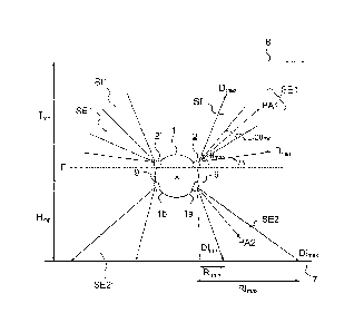
As can be seen in figure 6, the minimum Omin and
maximum eimax elevation angles are defined so as to image
a water column extending horizontally and transversally
(that is to say at right angles to the main direction
D) between a predefined minimum range Rrrin (defined by
the direction Dmax) and a predefined maximum range Rmax
(defined by the direction Dmin) and, vertically, between
a predefined minimum depth Iann and a predefined maximum
depth Imdx. The depth of an object is the vertical
distance separating this object from the surface level
of the water. The minimum elevation angle Ruin and the
maximum elevation angle Omax depend on the depth Imsi of
the mechanically steered sonar 2 at constant altitude
Hs, in relation to the seabed 7, and also on Rrnjii, Rmax,
and 'max. The maximum depth IrRax is chosen so as to
be less than the depth Ifm of the seabed and the minimum
depth must be greater than 0 to be below the surface of
the water 8. The directions Dm, and Dilidx can exhibit
positive or negative elevation angles Oru, and Omax, the
condition being that, for the depth of the sonar 2, the
volume imaged when the pointing direction points in
these directions in the volume defined between Ruin and
Rmax, Imin and 'max is a volume of water and not the
seabed. In other words, between the minimum and maximum
range distances and the minimum and maximum depths the
sonar 2 images the volume of water in which it is
dipped. In the embodiment of figures 3 and 6, the
elevation angles are positive, the pointed directions
are always pointed upward.
The processing unit 5 is embedded on board the
carrier 1. This processing unit 5 can comprise one or
more computers or can be a computation function of a
computer. It can as a variant be partially remotely
sited away from the carrier, for example on a ship, on
CA0292415120161
- 20 -
land or on board an aircraft, and partially on board
the carrier. It can also be entirely remotely sited.
The processing unit 5 is advantageously configured
so as to calculate the minimum and the maximum Ruin, Omax
angles during the mission, for example at regular time
intervals as a function of the depth Imp of the carrier
1, of the position of the sonar 2 on the carrier, and
possibly as a function of its attitude, notably of its
list. The depth of the carrier Imp is advantageously
supplied to the processing unit by a positioning unit 6
configured so as to determine the position and possibly
the attitude of the carrier 1 at regular time
intervals, for example, at the first successive
insonification instants and to supply them to the
processing unit 5. In other words, the positioning unit
6 is configured to supply the processing unit 5 with
the space-time trajectory of the carrier 1 and possibly
its attitude as a function of time. It can be an
acoustic and/or inertial positioning device or any
other type of positioning device. This device is
advantageously embedded on board the carrier 1.
The processing unit 5 supplies these angles R.,
emax to the scanning sonar 2, possibly together with a
scanning speed, an angular tilt step SO and a scanning
mode (two-way or one-way, for example). As a variant,
the depth of the carrier 1 is assumed predefined and
these data are supplied to the sonar 2 before the
mission, notably the angles Orain, max are computed
before the mission.
In one embodiment, the method comprises a
detection step 30, performed by the processing unit,
consisting in detecting first potential echoes having
been created by objects of neutral buoyancy floating
mid-water by means of first signals. This step
CA0292415120161
- 21 -
comprises unitary detection steps 301 from respective
first signals sl,. A unitary detection step 30,
associated with a sonar acquisition step 20, consists in
determining first potential echoes Ell] considered as
having been created by potential floating objects Op,_3
of indices I and j with j = 1 to Mi where Mi is the
number of potential objects detected for the sonar
acquisition step 20i, from the first acoustic signal sli
acquired by the sonar 2 in the sonar acquisition step
20i of the same index. A first potential object Op,j is
considered to have created a first echo when the latter
satisfies a predefined selection criterion. In other
words, a first potential echo is a part of the first
acoustic signal satisfying a predetermined selection
criterion.
The unitary detection step 30i advantageously
comprises an identification step 32i in which there are
identified, by a method of thresholding of the contrast
of the first signal, the first potential echoes E1,1 1 =
1 to L included in the first signal and exhibiting a
contrast, that is to say a signal-to-noise ratio above
a predetermined contrast threshold where L is the
number of echoes exhibiting a contrast above the
contrast threshold.
This contrast threshold can be fixed. It can be a
function of the time separating the instant of emission
of the acoustic pulse and the instant of reception on
the first signal, that is to say the function of the
distance separating an echo from the sonar.
The contrast threshold can be computed dynamically
to obtain a constant false alarm rate, that is to say a
constant rate of detections of potential objects which
are not real objects relative to the detections of
potential objects which are real objects. The detection
CA 029241512015-09-11
- 22 -
threshold can, for example, be fixed to obtain on
average a constant detection density over the entire
swath.
The identification step 32i is possibly preceded
by a step of normalization 31i of the intensity of the
first signal sll as a function of the duration
separating the instant of emission of the acoustic
pulse and the instant of reception to allow for the
application of a constant contrast threshold.
The unitary detection step 30i advantageously
comprises an elimination step 33i, in which the first
potential echoes Elil created by potential objects Opil
deriving from the surface reverberation and/or
potential objects deriving from the seabed and/or
potential objects situated outside the zone of interest
included between the minimum and maximum ranges R21101
are eliminated. In this case, the selection
criterion is a dual criterion of position and of
intensity (or of contrast). First potential echoes El,_]
are then obtained.
The elimination step 33i consists, for example, in
eliminating the first potential echoes Eli- situated at
a distance from the mechanically steered sonar 2 that
does not lie within a distance interval. The
elimination step uses the elevation angle of the
pointed direction P, in the insonification step 22i and
the instant of insonification 22i and of the instant of
reception of the first associated potential echo Elu as
well as the depth of the sonar 2. The distance interval
is advantageously the distance interval outside of
which the potential objects detected are situated at a
depth greater than the maximum depth 1. or at a depth
less than the minimum depth Imin and/or at a horizontal
distance from the sonar less than the minimum range Rffiln
CA0292415120161
- 23 -
or greater than the maximum range Rmax. The method
according to the invention therefore makes it possible
to very simply reject the potential objects deriving
from reverberation from the surface or from the bottom
when the pointing direction is directed respectively
toward the surface or toward the bottom.
On completion of the unitary detection step 301,
an uncertainty remains as to the position of the
potential objects Opij because of the relative bearing
aperture of the individual sector. It is known how to
compute the slant range rij (that is to say the
distance) separating the potential object Opij and the
sonar 2, the horizontal distance RI] separating the
object from the sonar (from the elevation angle O of
the pointed direction Pi at the moment of insonification
22i, of the slant range rij and possibly the attitude of
the carrier if it is not fixed), as well as its depth
Imij (from the elevation angle 0,, the pointed direction
Pi at the instant ti of insonification 22õ the depth
Ims, of the carrier at the instant of insonification and
possibly from its attitude).
The depth Imij of the object is given by the
following formula:
Im = Im - r sin (0,]) [1]
The horizontal distance Rij is given by the
following formula:
= sin (0,j)*r,j [2]
On the other hand, it is not possible to
accurately know the position of the potential object in
the horizontal plane. This object can occupy a set of
potential positions corresponding to a circular arc,
the center of which is the position of the sonar 2 at
the instant of emission of the acoustic pulse and the
radius of which is the slant range r,j. That is
CA0292415120161
- 24 -
represented in figure 7. This figure shows the
trajectory of the sonar 2, the positions Psi, Psific of
the carrier 1 at the first instants of insonification
of indices i and i+k which are successive instants of
insonification according to the pointed directions
exhibiting a same elevation angle and separated by a
scanning period. The set of positions potentially
occupied by a potential object Opi:, Opic:, having
generated a first echo deriving from the insonification
step 22i, respectively 22i+k, and being situated at the
slant range ri3, respectively ri+kj,, of the carrier is a
circular arc Ci3, respectively C14-1W, of radius
respectively ri+k],, the center of which is the position
Psi, respectively and
symmetrical relative to the
vertical plane in which the pointed direction Pi, Pi+k
is located. In the embodiment of figure 7, the angular
apertures of these circular arcs aij, and respectively
ai+kj, equal to 203H. It will be seen that the angular
apertures can be greater than 203H.
Another drawback is that the detections can
exhibit a not inconsiderable number of false alarms.
Advantageously, the scanning is performed in such
a way as to image more than once a one-off object fixed
in the terrestrial reference frame and located at right
angles to the direction D, at a horizontal distance
from the sonar at least equal to the minimum range Rmin
and less that the maximum range Rmax of the sonar 2 and
between the minimum Ir= and maximum 'max depths, when
the carrier advances at a predetermined speed Vavg by
rectilinear movement. It is stated that the system is
configured so as to produce a number of target hits.
Thus, a number of first echoes are acquired that
originate from the object in the scanning step and
these echoes are used to locate neutral buoyancy
CA0292415120161
- 25 -
objects effectively floating mid-water from the first
potential echoes created by the potential objects. This
feature makes it possible to limit the chances of not
detecting a target.
In other words, the scanning speed, the scanning
angle 0 and the sector to be imaged are chosen so as to
image more than once an object situated in the space
defined by P
Rrnax I min Imax by means of the first
individual sector SE1 at -3dB of the sonar during the
scanning step.
This can be done by configuring the sonar system
in such a way that an object fixed in the terrestrial
reference frame and located, at right angles to the
direction D, at a distance at least equal to a minimum
overlap, is located more than once within the
individual sector SE1 during an imaging step, when the
carrier advances at a speed vavg.
Figure 8 gives a different representation of the
different positions PSEli, PSEli+k, PSE11+2k occupied by
the first individual sector SE1 as well as the
respective positions occupied by the sonar Psi, Psi+k,
P51+2k, in three insonification steps 22i, 22i+k, 22i+2k,
separated in pairs by the scanning period, in which the
respective pointed directions Pi, P,k, P1-F2k exhibit the
same elevation angle. In other words, in these
insonification steps, the first individual sector SE1
occupies the same position in relation to the carrier,
that is to say the same orientation in the vertical
plane.
These fixed one-off objects are imaged at least
three times within the first individual sector when the
scanning sonar scans the first individual sector more
than once at constant scanning speed if they are
situated at a horizontal distance at right angles to
CA0292415120161
- 26 -
the direction D at least equal to a first threshold
distance Rhole =
R = Davg
hole tan(2e,H [3]
'
in which 203H is the horizontal aperture of -3dB of the
transmit pattern of the scanning sonar 2, and in which
Davg is the average distance travelled by the carrier
during the scanning time. The value of the average
distance is given by the following equation:
Ddvg = Vsvg * Tscan [4]
In which Vavg is the average speed of the carrier during
the scanning step and in which Tscan is the scanning
time.
It must be noted that the first echoes received by
the mechanically steered sonar 2 are not derived solely
from the objects situated within the first individual
sector at the time when they are imaged, they can also
be derived from objects situated in the rest of the
main lobe or outside of this sector. The acoustic pulse
in effect exhibits a transmit pattern in sin 0/0 form
exhibiting a maximum at the level of the pointed
direction. The sonar can therefore receive echoes from
objects situated within secondary lobes of the
transmitted acoustic signal. The objects situated close
to the sonar, for example, at a distance from the sonar
less than Dhoier will return an echo exhibiting a
significant intensity or contrast, which makes it
possible to detect them in the individual detection
step by thresholding even if they are situated outside
of the individual sector at -3dB. They will therefore
also be able to be detected a number of times when the
sonar advances.
CA0292415120161
- 27 -
This means that the second threshold distance Rhoie
can be greater than the minimum range Rmin for the
method according to the invention to work or that the
radius of the circular arc retained to represent the
set of potential positions can be a circular arc
exhibiting an aperture greater than the horizontal
aperture at -3dB (relative bearing aperture SE1) but,
for example, an aperture equal to the horizontal
aperture at -10dB or at -20dB.
Advantageously, the scanning is performed so as to
produce at least three target hits. That makes it
possible to guarantee a certain positioning accuracy.
The method according to the invention
advantageously profits from the plurality of target
hits to reduce the false alarm rate and accurately
locate, in the three dimensions of space, the potential
objects.
To this end, the method advantageously comprises a
step of determination of potential positions 40
comprising, for each first potential echo Eli], a step
of determination 41,j of a set of potential positions
P0p,i that the potential object which has created the
first potential echo is likely to occupy. These
potential positions are determined from the position of
the sonar 2 at the instant of emission of the acoustic
pulse originating from said first potential echo Elij.
The position of the sonar 2 is advantageously computed
by the processing unit 5 from the position of the sonar
in relation to the carrier and from the position of the
carrier. As a variant, the positioning unit 6 directly
supplies the position of the sonar to the processing
unit 5.
These potential positions POpij, can be two-
dimensional positions in the horizontal plane. In this
CA0292415120161
- 28 -
case, as explained previously with reference to figure
8, the set of potential positions that a potential
object Op ij can occupy is the projection, in a
horizontal plane, of a circular arc C1], the center of
which is the position Psi, which is symmetrical in
relation to the vertical plane in which the pointing
direction Pi is located and the radius of which is the
slant range r,j separating the potential object from the
sonar 2. These circular arcs Cjj can exhibit an angular
aperture equal to the relative bearing aperture of the
first individual sector SE1 or equal to the relative
bearing aperture of the first individual sector plus a
predetermined tolerance aperture corresponding to a
fraction of the aperture of the first individual sector
so as to take account of objects detected outside of
the first individual sector. As stated previously, the
angular aperture of the circular arc can for example be
equal to the horizontal aperture at -10dB or at -20dB.
The method also comprises an accumulation step 50
in which fixed positions Pf in the terrestrial
reference frame are assigned respective probabilities
of occupancy corresponding to probabilities of being
actually occupied by an object. These probabilities are
initialized, for example at 0, in a step 51 at the
start of the accumulation step and incremented 521j
each time that said fixed positions are identified as
being potential positions in the step of determination
of the sets of potential positions 40. The fixed
positions Pf assigned probabilities are cells of a grid
10 represented in figure 7.
In the case where the potential positions are two-
dimensional positions in the horizontal plane, the
fixed positions assigned probabilities are cells of a
CA0292415120161
- 29 -
two-dimensional grid, the sides of which are parallel
and at right angles to the direction D.
The method comprises a step of identification 60
of effective positions which are positions effectively
occupied by an object out of the fixed positions, the
effective positions being obtained from fixed positions
assigned a probability of occupancy above a
predetermined probability threshold. This step makes it
possible to select only the objects seen a sufficient
number of times. On completion of this step, the non-
relevant potential objects (not seen a sufficient
number of times by the method) have been eliminated. It
has notably been possible to eliminate fish in motion
contrary to the moored mines occupying positions that
are substantially fixed and other false alarms.
The effective positions correspond to the two-
dimensional positions which are assigned the maximum
probability in a circle of radius less than a
predetermined threshold (local maximum).
In the case of figure 7, the fixed positions are
all either assigned a probability equal to 1 for the
fixed positions (or cells) over which a circular arc
extends, or a probability equal to 0 for the fixed
positions over which a circular arc does not extend, or
a probability equal to 2 only for the fixed position
situated at the intersection of the two circular arcs.
The increments can be fixed. As a variant, the
increment is all the greater when the contrast of the
first echo created by the potential object is great.
That makes it possible to grant greater credit to a
strong echo, that is to say an echo with a significant
contrast.
The step of location of the objects comprises a
step of computation 70 of the vertical co-ordinates
effectively occupied in the vertical plane from
C.A0241_5120161
- 30 -
elevation angles of the pointed directions in emissions
of the acoustic pulses originating the first potential
echoes created by the potential objects occupying
potential positions corresponding to the positions
assigned probabilities above the probability threshold
and from the distances separating the potential objects
and the mechanically steered sonar. This value can be
obtained from an average or from a median of the
elevation angles of the pointed directions in the
insonification steps originating first potential echoes
considered.
In other words, the step of location of the
objects comprises a step of computation 70 of the
vertical co-ordinates effectively occupied in the
vertical plane from the depths of the potential objects
occupying potential positions corresponding to the
positions assigned probabilities above the probability
threshold and from the distances separating the
potential objects and the sonar. The depth of a
potential object is defined by the formula [1]. This
method described previously makes it possible to locate
the object with a good accuracy in the three dimensions
of space. The resolution in the vertical direction is
defined by the elevation aperture of the first
individual sector.
As a variant, the fixed positions are three-
dimensional geographic positions. They are for example
cells of a three-dimensional grid, the height of which
corresponds to the aperture of the first individual
sector plus a possible predefined elevation tolerance
(variable as a function of the horizontal distance
separating a cell from the sonar 2). The method
therefore makes it possible to obtain a vertical
resolution corresponding to the elevation aperture of
the first individual sector.
In this case, the step of location of the objects
having neutral buoyancy corresponds to the step of
selection 60 of the effective positions.
CA0292415120161
- 31 -
Advantageously, the system according to the
invention comprises, as can be seen in figure 1, at
least one side-scan sonar 9 intended to image the
seabed 7 in a second oriented pointing direction PA2
visible in figure 3, in a second individual sector SE2
exhibiting a wide relative bearing aperture and a
narrow elevation aperture, the side-scan sonar 9
forming a plurality of reception channels in relative
bearing terms and being mounted on the carrier 1 such
that the second pointing direction PA2 is oriented
substantially laterally to the carrier 1, preferably
substantially at right angles to the main direction D,
on the same side of the carrier 1 in relation to the
vertical plane passing through the main direction D as
the first pointing direction PAl. The sonar can be a
synthetic aperture side-scan sonar.
In a seabed imaging step 100 concurrent with the
scanning step 20, the side-scan sonar transmits, in
steps 100t (with t = 1 to N for example), second
successive acoustic pulses at second successive
instants of insonification and acquires, in steps 101t,
second successive acoustic signals si2 resulting from
the respective second acoustic pulses. Advantageously,
the second successive instants of insonification are
the same instants as the first successive instants of
insonification. In other words, the sonars are
synchronized. That makes it possible to avoid having
the sonars interfere with each other. Consequently, the
sonars have the same pulse repetition rate and
therefore the same range. Advantageously, the emission
frequency bands of the two sonars are not superposed.
The system further comprises a human-machine
interface 10, arranged, for example, on a surface ship,
comprising a display device 11 intended to display, in
a step 110, simultaneously, as represented in figure 9,
a first sonar image Ii representing first acoustic
signals and a second sonar image 12 representing second
acoustic signals acquired during a same period of
CA0292415120161
- 32 -
acquisition by the mechanically steered sonar and
respectively by the side-scan sonar. In other words,
the display device comprises means for generating the
sonar images from the first and second acoustic
signals. The echoes originating from objects are
visible on the images and represent significant
intensities.
The human-machine interface is configured such
that, when the first and second images are displayed
simultaneously, an operator can, when they visually
identify, on the first image, a first echo created by a
submerged object having neutral buoyancy, visually
identify instantaneously, on the second image, if a
second echo has been reflected by an object placed on
the seabed substantially directly below the submerged
object.
In other words, the human-machine interface is
configured such that an operator can visually
simultaneously locate, instantaneously on the two
images, first and second echoes situated substantially
directly above and below one another. In other words,
the human-machine interface is configured such that an
operator can simultaneously visually locate first
echoes and second echoes from substantially a same
geographic co-ordinate, in a terrestrial reference
frame, on the two images. This feature makes it
possible to eliminate false alarms notably by allowing
an operator to distinguish first echoes from free
floating objects such as fish from moored mines linked
to an object placed on the seabed 7. In the embodiment
of figure 9, the first image Il and the second image 12
are displayed simultaneously. These respective images
Ii, 12 represent the intensities of the echoes included
in the first and second signals. The display device is
configured such that the first image and the second
image displayed are of substantially identical sizes
and that a first echo and a second echo from objects
situated at a same distance, that is to say slant
CA0292415120161
- 33 -
range, from the mechanically steered sonar and
respectively from the side-scan sonar are represented
substantially at a same abscissa and that a first echo
and a second echo generated following a first and
respectively a second simultaneous pulse are situated
at a same ordinate on the two images Ii and 12. The two
images are said to be geographically synchronized. As a
variant, the first images can be superposed while being
distinguished by two symbologies. The first and second
echoes can, for example, be represented by two
different colors.
Advantageously, in the embodiment of figure 9, the
first image II_ and the second image 12 comprise first
echoes Ela, Fib, Elc, Ele, Elf, Elg and second echoes
E2a, E2b that are very intense according to a same
system of co-ordinates. Figure 9 does not show the
echoes originating from objects situated outside the
respective observation zones of the two sonars, for
example, from reverberation from the surface of the
water. These echoes are advantageously attenuated or
eliminated before the display step 110. The background
noise is represented in white and a bright echo on a
sonar image is here represented in black. In this
figure, the display mode is an instant mode t of
emission of the acoustic pulse originating the echo
included in the acoustic signal (on ordinate)/distance
d (on abscissa) separating the object having created
the echo from a predetermined point that is fixed in
relation to the sonars. The fixed point is, for
example, the position of the sonars which are
substantially in line with one another. This distance
is computed by the processing unit. The instant of
emission of the acoustic pulse is representative of the
position of the object according to the main direction
D with uncertainties substantially corresponding to the
relative bearing apertures of the individual sectors at
-3dB of the two sonars.
CA0292415120161
- 34 -
In other words, the first image Ii represents the
intensities of the first acoustic signals as a function
of the first instants of emission of the first acoustic
pulses, on ordinate, and, on abscissa, as a function of
the distance separating an object having created an
echo included in the signal from the mechanically
steered sonar, that is to say as a function of the
acquisition instant. The second image represents the
intensities of the second acoustic signals as a
function of the second instants of emission of the
second acoustic pulses, that is to say as a function of
the acquisition instant on ordinate, and, on abscissa,
as a function of the distance separating an object
having created an echo included in the signal from the
side-scan sonar. The display device is configured such
that the echoes from identical instants of emission are
displayed at the same ordinate on the window or the
display screen 17 and the distance scale and the origin
of the range of distances displayed are the same for
the two images.
On the first image Ii, two triplets of first
successive echoes Ela, Elb, Tic and successive echoes
Ele, Elf, Elg are distinguished. This is due to the
fact that the mechanically steered sonar 2 is
configured to produce at least three target hits. A
floating object will therefore be detected three times
by the sonar in the scanning step while the carrier is
moving in the direction D during three imaging steps in
which the pointed directions exhibit a same elevation
angle (that is to say separated in time by the scanning
period). The slant range separating the echo from the
sonar 2 increases between the echo Ela and the echo Elb
and decreases between the echo Elb and the echo Elc.
This is due to the fact that, in its movement, the
carrier approaches the fixed floating object and then
moves away therefrom. The same applies for the triplet
of points Eld, Elf, Elg.
C.A0241_5120161
- 35 -
In the second image, a second echo E2a is from
a second emission simultaneous with the first emission
from which the echo Fib is derived because they are
situated substantially at the same ordinate. Moreover,
these echoes, being situated substantially at the same
abscissa, are situated
at the same distance from the
two sonars 2, 9. There are therefore high probabilities
that the object which has created the echoes Ela, Fib
and E1c is a moored mine even though there are no
second echoes visible on the second image 12 in the
vicinity of the echoes Ele, Elf, Fig. These first
echoes are probably from a free floating object. The
same applies for the echo E2b which, not having any
corresponding first echo in its vicinity, is probably
from an object placed on the seabed.
The display as described previously therefore
allows an operator to classify the echoes or to confirm
detections of effective objects obtained by the
processing unit. Advantageously, the human-machine
interface 10 comprises a classification unit 12
allowing an operator to classify, in a step 120, first
echoes visible on the first image (in the case of a
manual detection), or first effective echoes identified
by the processing unit 5, as being effectively from a
submerged object having neutral buoyancy (in the case
of an automatic detection) in a first class taken from
a plurality of classes comprising a moored mine class
and a free floating object class.
The processing unit 5 can also be configured to
locate only the first echoes classified in the moored
mines class by the operator. The locating is then
performed simply by means of the pointed direction for
the acquisition of the echo concerned and of the
instant of reception of this echo.
Advantageously, the human-machine interface
comprises tracking means 13 allowing an operator to
simultaneously move a first cursor 51 and a second
cursor 52. These cursors are displayed by the display
CA0292415120161
- 36 -
device. The first cursor 51 is displayed on the first
image Ii. The second cursor 52 is displayed on the
second image 12. In other words, the cursors 51, 52 are
superimposed on the respective images Ii and 12. The
display device is configured such that the two cursors
occupy, on the two images, respective positions
corresponding to a same geographic position in a
terrestrial reference frame, called pointed position.
Otherwise, the co-ordinates occupied by the two cursors
on the two images correspond to identical geographic
positions in the terrestrial reference frame. With this
cursor, it is not essential to provide images of the
same size in figure 9. The tracking means comprise, for
example, a mouse, a set of keys allowing an operator to
direct the cursor in different directions, or even a
touch zone.
Advantageously, as can be seen in figure 9, the
cursor 51 displayed on the first image Ii is provided
with a curve 53 computed dynamically by the processing
unit or the display device. The curve 53 depends on the
position pointed to by the cursor. It extends around
the position pointed to by the cursor and is configured
so as to represent a set of possible positions, on the
first image, of echoes created by an object having
created an echo represented at the position pointed to
by the cursor on the image. Thus, if the cursor is
placed at Elb, the associated curve will pass through
the points Elc and Ela. This cursor makes it possible
to visualize the expected position of successive echoes
of an immobile object in the volume of water and thus
assists the operator in identifying the possible echoes
from contacts of interest. This curve is computed
approximately as follows:
When the cursor points to a position having the
co-ordinates t, and r, where t, corresponds to an
instant of insonification t, originating an echo and r,
represents an slant range between an object originating
the echo and the volume scanning sonar, the position
CA0292415120161
- 37 -
ri+k of the curve on the distance axis situated on the
time axis at the instant ti+k is thus computed:
k ri2 + (Davy X ICY
r,k = ri+-k. The curve 53 is preferably centered around
the position i along the time axis t.
Advantageously, as represented in figure 9, the
display device is configured to display superimposed on
the first image and/or the second image, symbols SE at
effective positions considered as being effectively
occupied by the echoes detected by the processing unit
5. That allows an operator to concentrate on the zones
where first effective echoes have already been detected
so as to speed up and improve the relevance of the
classification. In figure 9, a symbol SE corresponding
to the effective position identified by the processing
unit from the three first echoes Ela, Elb, Elc is
displayed only on the first image. The symbol SE is a
square in the nonlimiting example of figure 9.
Advantageously, as represented in figure 3, the
side-scan sonar is configured so as to image the seabed
7 in a zone of observation delimited by a minimum
observation range RImn and a maximum observation range
RImax defined by the respective directions DI= and Dliaax
delimiting the second individual sector SE2
corresponding to the horizontal distances at right
angles to the direction D close to the height of water
between the bottom and the side-scan sonar and
respectively beyond which the echo becomes too weak.
Advantageously, the minimum and maximum
observation ranges DImIn and DImax are substantially
equal to the minimum and maximum ranges Rinin and Rnax of
the mechanically steered sonar 2. This configuration
makes it possible to carry out the search for moored
mines and mines placed on the seabed simultaneously
over a same sweep and in a same zone which makes it
possible to optimize the trajectory of the carrier and
C.A0241_5120161
- 38 -
therefore the time taken to inspect a wider zone to be
inspected.
The mechanical scanning and side-scan sonars
operate at frequencies ranging from several tens to
several hundreds of kHz to exhibit an angular
resolution compatible with the size of the mines.
Advantageously, the first and second acoustic pulses
exhibit a bandwidth of at least equal to 50 kHz. This
feature makes it possible to limit the echoes deriving
from the reverberation from the surface of the water
and increase the contrast of the objects to be
detected.
In the embodiment of the figures, the system
according to the invention comprises two side-scan
sonars and two mechanically steered sonars arranged on
the two flanks of the carrier, that is to say on either
side of the direction D, and configured so as to image
the seabed and the marine environment laterally to the
carrier on both sides of a vertical plane passing
through the direction D symmetrically in relation to
this plane as represented in figure 3 which shows the
other first and second individual sectors SE1', SE2'
transmitted by the other scanning 2' and lateral 9'
sonars symmetrical to the scanning sonar 2 and
respectively to the side-scan sonar 9 in relation to
the vertical plane passing through D. A different
number of side-scan sonars and mechanically steered
sonars can be envisaged.