Note : Les descriptions sont présentées dans la langue officielle dans laquelle elles ont été soumises.
CA 02933853 2017-01-18
DETERMINING APPRAISAL LOCATIONS
IN A RESERVOIR SYSTEM
FIELD OF THE DISCLOSURE
[0001] The present disclosure generally relates to systems and methods for
determining appraisal locations in a reservoir system.
[0002] More particularly, the present disclosure relates to determining
appraisal
locations in a reservoir system by generating, selecting and ranking a list of
priority appraisal
locations based on an adjusted hydrocarbon recovery potential.
BACKGROUND
[0003] Operators entering new prospect areas with little well control must
make
decisions on locating a limited number of exploratory wells. Large prospect
areas can be
characterized by a variety of different mineral rights, surface-permitting
obligations,
uncertainties in geologic subsurface characteristics, complexity of
topography, a variety of
available infrastructures, potential operational issues, and environmental and
regulatory
challenges.
[0004] The decision to appraise an acreage position is thus, very complex and
has a
high level of risk.
BRIEF DESCRIPTION OF THE DRAWINGS
[0005] The present disclosure is described below with references to the
accompanying drawings in which like elements are referenced with like
reference numerals,
and in which:
1
CA 02933853 2016-06-21
WO 2015/112233 PCT/US2014/064583
[0006] FIG. 1 is a flow diagram illustrating one embodiment of a method for
implementing the present disclosure.
[0007] FIG. 2 is a chart illustrating examples of appraisal location patterns.
[0008] FIG. 3 is a graph illustrating optimal portfolio delineation.
[0009] FIG. 4 is the graph in FIG. 3 illustrating the addition of different
patterns of
appraisal locations.
[0010] FIG. 5 is a map illustrating the frequency of the different appraisal
locations in
FIG. 4.
[0011] FIG. 6 is a map illustrating the different appraisal locations in FIG.
5 that
represent critical decisions.
[0012] FIG. 7 is a map illustrating the different appraisal locations that
represent critical
decisions in FIG. 6 with a priority code.
[0013] FIG. 8 is a map illustrating the different appraisal locations with a
priority code in
FIG. 6 that honor predefined constraints.
[0014] FIG. 9 is a list illustrating an example of the different appraisal
locations after
they are ranked.
[0015] FIG. 10 is a flow diagram illustrating one embodiment of a method for
performing step 1 in FIG. 1.
[0016] FIGS. 11A-11B are a flow diagram illustrating one embodiment of a
method for
performing step 2 in FIG. 1.
[0017] FIG. 12 is a flow diagram illustrating one embodiment of a method for
performing step 3 in FIG. 1.
2
CA 02933853 2016-06-21
WO 2015/112233 PCT/US2014/064583
[0018] FIG. 13 is a flow diagram illustrating one embodiment of a method for
performing step 4 in FIG. 1.
[0019] FIG. 14 is a flow diagram illustrating one embodiment of a method for
performing step 5 in FIG. I.
[0020] FIG. 15 is a flow diagram illustrating one embodiment of a method for
performing step 6 in FIG. 1.
[0021] FIG. 16 is a block diagram illustrating one embodiment of a computer
system for
implementing the present disclosure.
DETAILED DESCRIPTION OF THE PREFERRED EMBODIMENTS
[0022] The present disclosure overcomes one or more deficiencies in the prior
art by
providing a system and methods for determining appraisal locations in a
reservoir system by
generating, selecting and ranking a list of priority appraisal locations based
on an adjusted
hydrocarbon recovery potential.
[0023] In one embodiment, the present disclosure includes a method for
determining
appraisal locations in a reservoir system, which comprises: i) creating a
geocellular model using
a computer processor; ii) defining a first priority area for the geocellular
model using
predetermined priority rule levels and one of a plurality of hydrocarbon
recovery production
values determined by a first simulation; iii) defining a second priority area
for the geocellular
model using predetermined priority rule levels and one of a plurality of
adjusted hydrocarbon
recovery production values determined by a second simulation based on the
first priority area,
wherein the second priority area is constrained by the first priority area;
iv) defining an optimal
portfolio for one or more appraisal patterns determined by a third simulation
based on the second
3
CA 02933853 2016-06-21
WO 2015/112233 PCT/US2014/064583
priority area using one of a plurality of objective function values determined
by the third
simulation, wherein the optimal portfolio is constrained by the second
priority area; v)
identifying common appraisal locations in the optimal portfolio; vi)
calculating a ranking value
for each respective common appraisal location using a respective critical risk
and opportunity
size; vii) discretizing each ranking value by predetermined priority levels;
viii) removing each of
the common appraisal locations inside a predetermined coverage area that do
not have a highest
priority level, the common appraisal locations inside the predetermined
coverage area that have
the highest priority level representing all remaining common appraisal
locations; and ix) creating
a sequential appraisal plan using the remaining common appraisal locations and
at least one of
available drilling activity and drilling capacity for a specified interest
period of the sequential
appraisal plan.
[0024] In another embodiment, the present disclosure includes a non-transitory
program
carrier device tangibly carrying computer-executable instructions for
determining appraisal
locations in a reservoir system, the instructions being executable to
implement: i) creating a
geocellular model; ii) defining a first priority area for the geocellular
model using predetermined
priority rule levels and one of a plurality of hydrocarbon recovery production
values determined
by a first simulation; iii) defining a second priority area for the
geocellular model using
predetermined priority rule levels and one of a plurality of adjusted
hydrocarbon recovery
production values determined by a second simulation based on the first
priority area, wherein the
second priority area is constrained by the first priority area; iv) defining
an optimal portfolio for
one or more appraisal patterns determined by a third simulation based on the
second priority area
using one of a plurality of objective function values determined by the third
simulation, wherein
4
CA 02933853 2016-06-21
WO 2015/112233 PCT/US2014/064583
the optimal portfolio is constrained by the second priority area; v)
identifying common appraisal
locations in the optimal portfolio; vi) calculating a ranking value for each
respective common
appraisal location using a respective critical risk and opportunity size; vii)
discretizing each
ranking value by predetermined priority levels; viii) removing each of the
common appraisal
locations inside a predetermined coverage area that do not have a highest
priority level, the
common appraisal locations inside the predetermined coverage area that have
the highest priority
level representing all remaining common appraisal locations; and ix) creating
a sequential
appraisal plan using the remaining common appraisal locations and at least one
of available
drilling activity and drilling capacity for a specified interest period of the
sequential appraisal
plan.
[0025] In yet another embodiment, the present disclosure includes a non-
transitory
program carrier device tangibly carrying computer-executable instructions for
determining
appraisal locations in a reservoir system, the instructions being executable
to implement; i)
creating a geocellular model; ii) defining a first priority area for the
geocellular model using
predetermined priority rule levels and one of a plurality of hydrocarbon
recovery production
values determined by a first simulation; iii) defining a second priority area
for the geocellular
model using predetermined priority rule levels and one of a plurality of
adjusted hydrocarbon
recovery production values determined by a second simulation based on the
first priority area,
wherein the second priority area is constrained by the first priority area;
iv) defining an optimal
portfolio for one or more appraisal patterns determined by a third simulation
based on the second
priority area using one of a plurality of objective function values determined
by the third
simulation, wherein the optimal portfolio is constrained by the second
priority area; v)
identifying common appraisal locations in the optimal portfolio; vi)
calculating a ranking value
for each respective common appraisal location; vii) discretizing each ranking
value by
predetermined priority levels; viii) removing each of the common appraisal
locations inside a
predetermined coverage area that do not have a highest priority level, the
common appraisal
locations inside the predetermined coverage area that have the highest
priority level representing
all remaining common appraisal locations; ix) creating a sequential appraisal
plan using the
remaining common appraisal locations and at least one of available drilling
activity and drilling
capacity for a specified interest period of the sequential appraisal plan; and
x) defining one or
more appraisal delineation areas by the remaining common appraisal locations
from the
sequential appraisal plan.
[0025a] In another embodiment, the present disclosure includes a computer
program
product comprising a computer readable memory storing computer executable
instructions
thereon that when executed by a computer perform the steps of: i) creating a
geocellular model;
ii) defining a first priority area for the gcoccIlular model using
predetermined priority rule levels
and one of a plurality of hydrocarbon recovery production values determined by
a first
simulation; iii) defining a second priority area for the geocellular model
using predetermined
priority rule levels and one of a plurality of adjusted hydrocarbon recovery
production values
determined by a second simulation based on the first priority area, wherein
the second priority
area is constrained by the first priority area; iv) defining an optimal
portfolio for one or more
appraisal patterns determined by a third simulation based on the second
priority area using one of
a plurality of objective function values determined by the third simulation,
wherein the optimal
portfolio is constrained by the second priority area; v) identifying common
appraisal locations in
the optimal portfolio; vi) calculating a ranking value for each respective
common
6
CA 2933853 2018-03-20
appraisal location using a respective critical risk and opportunity size; vii)
discretizing each
ranking value by predetermined priority levels; viii) removing each of the
common appraisal
locations inside a predetermined coverage area that do not have a highest
priority level, the
common appraisal locations inside the predetermined coverage area that have
the highest priority
level representing all remaining common appraisal locations; and ix) creating
a sequential
appraisal plan using the remaining common appraisal locations and at least one
of available
drilling activity and drilling capacity for a specified interest period of the
sequential appraisal
plan.
[0025b1 In yet another embodiment, the present disclosure includes a computer
program
product comprising a computer readable memory storing computer executable
instructions
thereon that when executed by a computer perform the steps of: i) creating a
geocellular model;
ii) defining a first priority area for the geocellular mode! using
predetermined priority rule levels
and one or' a plurality of hydrocarbon recovery production values determined
by a first
simulation; iii) defining a second priority area for the geoeellular model
using predetermined
priority rule levels and one of a plurality of adjusted hydrocarbon recovery
production values
determined by a second simulation based on the first priority area, wherein
the second priority
area is constrained by the first priority area; iv) defining an optimal
portfolio for one or more
appraisal patterns determined by a third simulation based on the second
priority area using one of
a plurality of objective function values determined by the third simulation,
wherein the optimal
portfolio is constrained by the second priority.' area; v) identifying common
appraisal locations in
the optimal portfolio; vi) calculating a ranking value for each respective
common appraisal
location; vii) discretizing each ranking value by predetermined priority
levels; viii) removing
each of' the common appraisal locations inside a predetermined coverage area
that do
6a
CA 2933853 2018-03-20
not have a highest priority level, the common appraisal locations inside the
predetermined
coverage area that have the highest priority level representing all remaining
common appraisal
locations; ix) creating a sequential appraisal plan using the remaining common
appraisal
locations and at least one of available drilling activity and drilling
capacity for a specified
interest period of the sequential appraisal plan; and x) defining one or more
appraisal delineation
areas by thc remaining common appraisal locations from the sequential
appraisal plan.
[0026] The subject matter of the present disclosure is described with
specificity,
however, the description itself is not intended to limit the scope of the
disclosure. The subject
matter thus. might also be embodied in other ways, to include different steps
or combinations of
steps simihr to the ones described herein, in conjunction with other present
or future
technologies. Moreover, although the term "step" may be used herein to
describe different
elements of methods employed, the term should not be interpreted as implying
any particular
order among or between various steps herein disclosed unless otherwise
expressly limited by the
description to a particular order. While the present disclosure may be applied
in the oil and gas
industry, it is not limited thereto and may also be applied in other
industries to achieve similar
results.
Method Des c ri p1 11)11
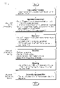
[0027] Referring now to FIG. 1, a flow diagram of one embodiment of a method
100
6b
CA 2933853 2018-03-20
CA 02933853 2016-06-21
WO 2015/112233 PCT/US2014/064583
for implementing the present disclosure is illustrated. The method 100 is
generally defined by
three processes. The first process determines an appraisal worth or value by
using a formula to
find the adjusted hydrocarbon recovery potential ("AHRP"), which is referred
to herein as
prospecting. The second process determines appraisal optimization in three
steps to generate,
select and rank a list of priority appraisal locations, which is referred to
herein as sieving. The
third process determines an appraisal sequence to drill the appraisal
location, which is referred to
herein as selling,
[0028] In step 1, data is managed, properties are populated and stochastic
models are
initiated using techniques well-known in the art.
The Prospecting Process
[0029] In step 2, the prospecting process is defined by equation 1:
AHRP = (HAP ¨ (Surf Imp. + Op. Imp. + Well Imp.)) * Opportunity Fact (1)
The terms are described as follows, which are expressed in MMstb:
AHRP: represents the adjusted hydrocarbon recovery potential, which indicates
an adjusted
value of hydrocarbon content for each area,
1-IRP: represents the hydrocarbon recovery potential for each area.
Surf, Imp.: represents the possible surface impact associated with the
permitting, topography,
and infrastructure costs.
Op. Imp.: represents the operational impact of the production delayed due to
the permissions
process.
Well Imp,: represents the impact of the total well costs (Drilling and
Completion) in each area.
7
CA 02933853 2016-06-21
WO 2015/112233 PCT/US2014/064583
Opportunity Fact: represents the opportunity factor, which is the possible
impact in terms of the
growth opportunity and risk ratio of an area defined by a coverage area of at
least about 2 miles
from the appraisal location.
Each of these terms is defined as follows:
[0030] The HRP in equation 1 is defined by equation 1
HRP = [00IP*PrimFr] (2)
where 00IP is the original oil in place measured in stb and PrimFr is the
primary recovery factor
measured in fractions.
[0031] The Surf. Imp. In equation 1 is defined by equation 3:
Surf. Imp. = (Permit. Fact + Infraestr. Fact] (3)
where Permit. Fact is the permitting factor, which is expressed by equation
3.1:
Permit. Fact. = (Well Total Np(Permit, Time)*Num, Wellsl*PI Fact. (3.1)
Permit. Time is the total time represented by the combination of the surface
and mineral rights
options. This parameter will determine the impact due to the production
delayed by the time that
it takes during the permit process. The Table 1 shows an example of these
options and the time
in months that each combination can take. Sometimes, there are combinations
that are not
possible and they are shown as n/a (not applicable) in Table 1.
8
CA 02933853 2016-06-21
WO 2015/112233 PCT/US2014/064583
Surface
Fee State Tribal Federal
Fee 1-2 ma 5-6 mo 6-7+ mo n/a
.16.2
a, State n/a n/a n/a n/a
tC Tribal 6-7+ mo 6-7+ mo 6-7+ mo n/a
Federal n/a n/a n/a 5-6 ma
Table 1, Permitting Time Matrix
Well Total Np (Permit.Time) is a production potential impact on the total
cumulative oil
production (Total NP) from the well type deferred by the permitting time. Num.
Wells is the
number of wells that potentially will be necessary to develop the area. PI
Fact. is the impact on
the potential production due to special conditions in the subsurface area that
can benefit the
production like the proximity to a fault system, This value is determined as a
weight factor by
using production engineering and/or statistics from analogous developed
fields.
[0032] Infrastr. Fact. is the impact that the lack of infrastructure in terms
of access to the
areas, the transportation, and land form, generate on the potential recovery,
which is expressed
by equation 3.1
Infrastr. Fact. = [Road fact. + Pipe fact.]* Topography fact. (32)
where Road Fact. is the cost impact by the unit cost needed to build
accessibility to the areas;
Pipe Fact. is the cost impact by the unit cost needed to build the pipeline to
the areas and
Topography Fact. is the impact on the infrastructure due to special conditions
at the surface
(landform) that can increase the cost such as the proximity to a canyon. This
value is determined
as a weight factor by using production engineering and/or statistics from
analogous developed
fields. Road Factis expressed by equation 3.2.1:
9
CA 02933853 2016-06-21
WO 2015/112233 PCT/US2014/064583
Road fact = [Relative distance to RoadrUnit Cost/Oil price
(3.2.1)
where Relative distance to Road is the distance to the nearest to a road; Unit
Cost is the road
unitarian cost in US$/mile and Oil Price is the oil reference price
established for economic
analysis. Pipe Fact. is expressed by equation 3,22:
Pipe fact = [Relative distance to Pipe]*Unit Cost/Oil price
(3.2.21
where Relative distance to Pipe is the relative distance to the nearest
Pipeline; Unit Cost is the
pipe unitarian cost in US$/mile and Oil Price is the oil reference price
established for economic
analysis.
[0033] The Op. Imp. in equation 1 is defined by equation 4:
OP. Imp = [Permit Factl*Operating Unit Cost/Oil price (4)
where Permit. Fact is the permitting factor expressed by equation 3,1;
Operating Unit Cost is the
operational unitarian cost in US$/stb and Oil Price is the oil reference price
established for
economic analysis.
[0034] The Well Imp. in equation 1 is defined by equation 5:
Well. Imp = [Average Depth*Num Wells*Unit Cost/Oil price]* Topography Fact.
(5)
where Average Depth is the average depth of the well type in the area in feet;
Num. Wells is the
possible total number of wells that can be drilled in the area; Unit Cost is
the well unitarian cost
CA 02933853 2016-06-21
WO 2015/112233 PCT/US2014/064583
in US$/ft.; Oil Price is the oil reference price established for economic
analysis and Topography
Fact. is the impact on the well cost due to special conditions at the surface
(landform). This value
is determined as a weight factor by using production engineering and/or
statistics from analogous
developed fields.
[0035] The Opportunity Fact in equation 1 is defined by equation 6:
Total Opport 00IP @ coverage acreage area
Opportunity Fact = ___________________________________________________ (6)
Total Risk 00IP @ coverage acreage area
where Total Opport. 00IP @ coverage acreage area is the size of the
opportunity defined by the
uncertainty range that will positively impact the expectation of the 00IP, and
Total Risk 00IP
@ coverage acreage area is the size of the risk defined by the uncertainty
range that will
negatively impact the expectation of the 00IP, These ranges are defined by
using 50% (P50) as
a reference of the 00IP wherein the extremes of the range are defined by the
Critical Risk (Per)
and the Critical Opportunity (Pco). Critical risk is the percentile value of
the objective variable
below which the risk associated with all intrinsic parameters is null or
negligible. Similarly,
critical opportunity is the percentile value of the objective variable above
which the opportunity
associated with all intrinsic parameters is null or negligible. The
Opportunity Fact is thus, an
indicator of hydrocarbon content in the coverage area of the appraisal
location.
[0036] The prospecting process in equation 1 is implemented in each element of
the
discrete exploratory system. The discretization of the exploratory system uses
grid techniques,
which are well-known in standard reservoir model engineering. Often the
exploratory areas in
USA are legally delineated by sections of 1 square mile then the Prospector
formula could be
11
CA 02933853 2016-06-21
WO 2015/112233 PCT/US2014/064583
applied in each section.
[0037] Each element of the prospecting process in equation 1 is managed by
sampling
rules defined in a stochastic simulation. This generates huge computational
processing. Thus, to
manage this issue in an efficient fashion, it is necessary to start with the
evaluation of the first
element in equation 1, which is expressed by equation 2, as the first stage of
a progressive
stochastic simulation. Then, a priority analysis is performed to simplify the
model by using a
"Pareto Analysis," which is a well-known statistical technique. The next stage
of the progressive
stochastic simulation (2"" stage in step 2) is to evaluate the other elements
in equation 1 on the
priority area defined in the first stage of the progressive stochastic
simulation. In this case, the
computational process is reduced because the model is simplified by
considering just the priority
area defined. The results of each stage are managed to create a new singular
probabilistic
variable, which will be used as an input in the next, third stage of
progressive stochastic
simulation. The probabilistic variables are modeled by using statistical
distribution function
techniques that are well-known in the art.
The Sieving Process
[0038] The Sieving process starts with the values generated by the prospecting
process in
equation 1 to generate, select and rank a list of priority appraisal
locations.
[0039] In step 3, the generation of appraisal locations considers different
patterns of
appraisal locations and obtains a maximum possible coverage of acreage with
minimum
appraisal locations. A reference position inside the area is selected and then
possible locations
honoring spacing among the others appraisal locations are generated. The
spacing is defined by
vertical spacing and horizontal spacing from the reference position, which is
defined by grid
12
CA 02933853 2016-06-21
WO 2015/112233 PCT/US2014/064583
coordinates in terms of columns and rows. All of them are decisions to be
considered in the
optimization process. The combinations of the different alternatives of these
decisions will
generate different patterns and each of them will be treated as a scenario.
[0040] FIG. 2 illustrates two particular scenarios as examples of appraisal
location
patterns generated by using specific options of the decisions variables used.
These decision
variables are the grid coordinates to define a reference initial position to
start the generation of
the locations pattern and spacing in the vertical and horizontal directions to
generate the other
locations necessary to accomplish the pattern. The appraisal locations are
represented by the
number 1. Scenario 1 shows one specific appraisal location pattern defined by
a location
reference represented by the boxed number 1 with grid coordinates (Col.=4,
Row=3). Other
locations are generated by honoring a vertical spacing of 2 miles (above and
below the horizontal
coordinate) and horizontal spacing of 3 miles (left and right of the vertical
coordinate). In
Scenario 1, therefore, four locations are generated. In Scenario 2, the
location reference grid
coordinates (3, 2) honor a vertical spacing of 1 mile and a horizontal spacing
of 1 mile. In
Scenario 2, therefore, six locations are generated,
[0041] The scenarios are generated following the rules defined in the
optimization
settings (step 3) as indicated by:
- Decisions to be optimized:
o Grid coordinates for the reference position inside the priority area,
obtained in the
second stage of the progressive stochastic simulation:
= Decision on the X location (XD)
^ Decision on the Y location (YD).
13
CA 02933853 2016-06-21
WO 2015/112233 PCT/US2014/064583
o Decision variable for the horizontal spacing among the appraisal
locations (D173).
o Decision variable for the vertical spacing among the appraisal locations
(D,).
- Uncertainties:
o The uncertainty variable is defined by the results of the evaluation of
AHRP
(equation 1) in the second stage of the progressive stochastic simulation,
which
are modeled with a statistical distribution function using techniques well-
known
in the art.
- The objective function is to maximize the total value of AHRP from
equation 1 on the set
of appraisal locations generated by the pattern established in the priority
area. The
objective function is thus, defined by equation 7:
n m
Total Value of the Set of Appraisal Locations = E E [AIIRP(x,,yi)1 (7)
,=1,Dhs j=i,D,,
where AHRP is the result obtained in the second stage of the progressive
stochastic simulation.
The values are generated through the use of sampling rules techniques well-
known in the art.
xi: represents the horizontal grid coordinates.
yi: represents the vertical grid coordinates,
n, m: represent maximum values of the grid coordinate.
Dhs: is an incremental value of xi and represents a decision on the horizontal
spacing among the
appraisal locations, in grid coordinates.
D,: is an incremental value of yi and represents a decision on the vertical
spacing among the
14
CA 02933853 2016-06-21
WO 2015/112233 PCT/US2014/064583
appraisal locations, in grid coordinates.
- Constraints:
o The total value of equation 7 must be positive.
o The opportunity factor from equation 6 has to be bigger than 1.
o In the spacing decisions, the minimum value is about 2 miles.
[0042] The scenarios are collected and ordered by their expected value and
their own risk
to generate a portfolio of the appraisal location patterns, which is performed
using well-known
risk analysis techniques. The objective of step 3 is to delineate an optimal
portfolio by using a
well-known methodology of Portfolio Theory. This optimal portfolio is commonly
known as
Efficient Frontier. The optimal portfolio is determined by those scenarios
that are on the optimal
expected value zone at different risk levels as illustrated in FIG. 3 by the
Efficiency Frontier
points and the Efficiency Trend.
[0043] In step 4, the optimal portfolio delineated in the step 3 is
represented by several
scenarios, which in turn each represents a specific pattern of appraisal
locations as described
before. It means that this system generates multiple solutions at different
risk levels. Thus, a
special portfolio management has to be performed.
[0044] The appraisal location patterns have a fixed shape but the nature does
not behave
with this fixed shape. Thus, the best appraisal locations must be selected.
Each of the scenarios
that define the optimal portfolio represents different patterns of appraisal
locations as illustrated
in FIG. 4 and therefore, many of these appraisal locations are in the same
place through these
scenarios. Thus, they are common decisions throughout the optimal portfolio.
These common
CA 02933853 2016-06-21
WO 2015/112233 PCT/US2014/064583
decisions are referred to as critical decisions.
[0045] To identify the appraisal locations that represent critical decisions,
a statistical
analysis is performed to determine the frequency of each appraisal location
that appears in each
element of the grid.
[0046] FIG. 5 illustrates the frequency of the appraisal locations for each
element of the
grid generated from the example in FIG. 4. The empty space indicates no
priority area and the
zeroes indicate no appraisal location count for this element in the grid. The
numbers 1 indicates
just one appraisal location identified through the scenarios in FIG. 4, which
are not critical
decisions. The numbers 2 and 3 indicate common locations through the scenarios
in the optimal
portfolio. Therefore, these locations are considered critical decisions and
will be taken into
account to generate the list of the appraisal locations ranked in the
following step. FIG. 6
illustrates the appraisal locations that represent critical decisions to be
considered in the
following step to generate the list of appraisal locations ranked.
[0047] In step 5, to rank the critical decisions, equation 8 is used to adjust
AHRP and
redefine the appraisal value:
Rank. Fact. AHRP = Wf 11(AHRP @Pcrit _risk)2 + (AHRP.Opport.Size)2 (8)
where Rank.Fact.AHRP represents a ranking factor of the AHRP and Wf is a
weight factor,
which is a normalized frequency of the common appraisal locations through the
scenarios
selected in the Efficient Frontier. The normalized frequency is estimated by
using techniques
well-known in the art. AHRP@Pcrit risk is the critical risk of the AHRP for
each appraisal
16
CA 02933853 2016-06-21
WO 2015/112233 PCT/US2014/064583
location that represents a critical decision and AHRROpport. Size is the size
of the opportunity
for AHRP in each appraisal location. The opportunity size of the AHRP in
equation 8, is defined
by equation 9:
Opport Size of AHRP = AHRP @ Pcrit _opport ¨ AHRP @ Pcrit risk (91
[0048] By applying equation 9, new adjusted values of AHRP are obtained and
then a
priority process (by using the "Pareto Analysis") is applied to discretize by
60:30:10 priority
levels, the appraisal locations, Each appraisal location is mapped in a
geographic map using its
corresponding priority code and techniques well-known in the art. FIG. 7
illustrates the appraisal
locations with a priority code. In FIG. 7, the priority code indicates the
level of importance so 1
is the best and 3 is the worst. The ranking process finishes initiating the
sequence analysis in the
selling process.
The Selling Process
[0049] In step 6, the example in FIG. 7 shows appraisal locations that are
inside of the
threshold defined by constraints set up in step 3, about the radius of 2 miles
as minimum spacing.
Therefore, a new filter has to be applied to eliminate those locations that
are not honoring this
constraint as illustrated in FIG. 8 with the appraisal locations remaining
after the filter process.
[0050] Then by using the adjusted AHRP from equation 9, the appraisal
locations are
ordered from highest value to the lowest value of Rank.Fact,AHRP to define the
list of the
appraisal locations ranked. FIG. 9 illustrates a particular example of the
appraisal locations list,
[0051] The Total AHRP it the total summation of the values of AHRP at P50,
obtained
after equation 1 in the second stage of the progressive stochastic simulation
described in step 2.
17
CA 02933853 2016-06-21
WO 2015/112233 PCT/US2014/064583
The Total AHRP represents a potential estimation of the proven reserves to be
booked after the
appraisal delineation of the field, The method 100 is totally quantitative and
integrates several
procedures that previously were managed separately and in a qualitative form.
The method 100
also uses a total stochastic approach and can be applied for different scale
studies from a single
well to corporate asset analysis of multiple wells.
[0052] Referring now to FIG. 10, a flow diagram of one embodiment of a method
1000
for performing step 1 in FIG. 1 is illustrated.
[0053] In step 1002, data is stored using the client interface and/or the
video interface
described further in reference to FIG. 16 for the following property
variables: i) Geological:
area, porosity, thickness, initial water saturation (Swi), initial oil
formation volume factor (Boi),
faults trend, and structural average depth; ii) Recovery attribute: primary
recovery; iii)
Production: initial well production potential, decline factors, well,
production time, production
index, (PI) factor; iv) Costs: drilling and completion, roads, pipeline,
operational; v) Maps: roads
and pipeline; vi) Oil price; vii) Landform description parameters: surface
permitting and mineral
right; viii) Permitting parameter: in terms of the surface permitting
(Private, State, Tribal,
Federal) and mineral right (Private, State, Tribal, Federal) combinations; ix)
Development
potential: possible number of well per section; x) Official spacing: threshold
appraisal spacing;
xi) Number of sections; and xii) IP description parameter.
[0054] In step 1004, a geocellular model is automatically created using the
number of
sections stored in step 1002 and techniques well known in the art.
Alternatively, the geocellular
model may be created using the client interface and/or the video interface
described further in
reference to FIG. 16. The geocellular model includes a grid representing the
number of
18
CA 02933853 2016-06-21
WO 2015/112233 PCT/US2014/064583
sections.
[0055] In step 1006, the number of sections in the geocellular model created
in step 1004
are populated with range names representing data values for the following
property variables
stored in step 1002 using well known anisotropic distribution techniques and
using the client
interface and/or the video interface described further in reference to FIG.
16: i) Geological:
porosity, thickness, initial water saturation (Swi), initial oil formation
volume factor (Boi),
structural average depth, parameter to describe the proximity to the fault
system; ii) Recovery
attribute: primary recovery; iii) Surface distances: relative distance of
section to the nearest
roads, relative distance of section to the nearest roads, pipelines; iv)
Permitting parameters, to
describe the landlord types in term of surface and mineral right; v) Landform
description
parameters and vi) IP description parameter. Each range name thus, represents
one or more data
values for a respective property variable,
[0056] In step 1008, a matrix is built for the surface permitting and mineral
right
combinations using the data range name values for the permitting parameters
from the
geocellular model populated in step 1006. The matrix is used to manage the
values from the
statistical distribution modelled in step 1120 that replace the range names
representing data
values for the permitting parameters populated in step 1006 and to solve the
AHRP formula in
step 1126.
[0057] In step 1010, a curve-type production vector is built using the data
values for the
property variables stored in step 1002. A new range name is assigned to each
time step in the
production vector using well known techniques in the art, wherein each range
name represents
the probability of production at a respective time step. The method 1000
returns to step 2 in
19
CA 02933853 2016-06-21
WO 2015/112233 PCT/US2014/064583
FIG. 1.
[0058] Referring now to FIGS. 11A-11B, a flow diagram of one embodiment of a
method 1100 for performing step 2 in FIG. 1 is illustrated.
[0059] In step 1102, the HRP variable in equation 1 is modeled using equation
2, wherein
HRP = f (Area, Porosity, Swi, Boi, Primary Recovery), the range name data
values for the
property variables (Area, Porosity, Swi, Boi, and Primary Recovery) from the
geocellular model
populated in step 1006, and techniques well known in the art.
[0060] In step 1104, a statistical distribution for each property variable
used in step 1102
for each section of the geocellular model populated in step 1006 is modeled
using the range
name data values for each property variable used in step 1102 and techniques
well known in the
art. Each statistical distribution model represents the uncertainty of the
property variables used
in step 1102 for the geocellular model.
[0061] In step 1108, a first simulation is initialized by i) defining settings
that include the
type of simulation, sampling rules, the number of realizations, and variables
results in a data
base; and ii) assigning each statistical distribution from step 1104 the range
name for each
respective property variable it represents from step 1102.
[0062] In step 1110, HRP in equation 1 is stochastically solved by performing
the first
simulation initialized in step 1108 using the models from step 1102 and step
1104.
[0063] In step 1112, the values for HRP from the first simulation in step
1110, which
represent realizations, are stored.
[0064] In step 1114, a first priority area is defined for the geocellular
model created in
CA 02933853 2016-06-21
WO 2015/112233 PCT/US2014/064583
step 1004 using predetermined priority rule levels based on techniques well
known in the art,
such as the Pareto method, the HRP value at P50 stored in step 1112 and using
the client
interface and/or the video interface described further in reference to FIG.
16.
[0065] In step 1116, the remaining variables in equation 1 are modeled using
equations
3-6, wherein: i) Surf Imp. ¨f(Permtt. Fact., Infraest. Fact); ii) Op. Imp.
=f(T. Well. Np, PI fact.,
N. Wells, Op. Unit. C, Oil P.); iii) Well Imp. =f(Averg. Depth, Topo. Fact.,
N. Wells, Well ,Unit.
C, Oil P.); and iv) Opportunity Fact. =f(T. Opport., T. Risk), the range name
data values for the
respective property variables from the geocellular model populated in step
1006, the production
vector from step 1010 for Permtt. Fact., T. Well. Np and techniques well known
in the art. A
range name is assigned to each dependent variable (i-iv) using techniques well
known in the art.
[0066] In step 1118, a statistical distribution for each HRP value stored in
step 1102 for
each section of the first priority area defined in step 1114 is modeled using
techniques well
known in the art. Each statistical distribution model represents the
uncertainty of the HRP values
stored in step 1112.
[0067] In step 1120, a statistical distribution for each property variable
used in step 1116
for each section of the first priority area defined in step 1114 is modeled
using the range name
data values for each property variable used in step 1116, the matrix built in
step 1008 and
techniques well known in the art. Each statistical distribution model
represents the uncertainty of
the remaining variables in equation 1. modeled in step 1116.
[0068] In step 1124, a second simulation is initialized by i) defining
settings that include
the type of simulation, sampling rules, the number of realizations, and
variables results in a data
21
CA 02933853 2016-06-21
WO 2015/112233 PCT/US2014/064583
base; and ii) assigning each statistical distribution from steps 1118 and 1120
the range name for
each respective property variable it represents from step 1116.
[0069] In step 1126, AIIRP in equation 1 is stochastically solved by
performing the
second simulation initialized in step 1124 using the equation 1 and the
statistical models from
steps 1118-1120.
[0070] In step 1128, the values for AHRP from the second simulation in step
1126,
which represent realizations, are stored.
[0071] In step 1130, a second priority area is defined for the geocellular
model created in
step 1004 using predetermined priority rule levels based on techniques well
known in the art,
such as the Pareto method, the AHRP value at P50 stored in step 1128 and using
the client
interface and/or the video interface described further in reference to FIG.
16. As a result, the
second priority area represents a subset of the first priority area defined in
step 1114. The
method 1100 returns to step 3 in FIG. 1.
[0072] Referring now to FIG. 12, a flow diagram of one embodiment of a method
1200
for performing step 3 in FIG. 1 is illustrated.
[0073] In step 1202, a statistical distribution for each AHRP value stored in
step 1128 for
each section of the second priority area defined in step 1130 is modeled using
techniques well
known in the art. Each statistical distribution model represents the
uncertainty of the AHRP
values stored in step 1128.
[0074] In step 1206, the objective function in equation 7 is modeled using
each statistical
distribution from step 1202 and techniques well known in the art, wherein Obj.
Funct.
22
CA 02933853 2016-06-21
WO 2015/112233 PCT/US2014/064583
f(SumAHRP(Xi, Yj))[. A range name is assigned to the objective function.
[0075] In step 1208, a third simulation is initialized by i) defining settings
that include
the type of simulation, sampling rules, the number of realizations, a
variables results data base,
the number of scenarios, the decision variables for the appraisal patterns,
the objective function
and optimization constraints; and ii) assigning each statistical distribution
from step 1202 the
range name for the objective function from step 1206.
[0076] In step 1210, the objective function defined by equation 7 is
stochastically solved
by performing the third simulation initialized in step 1208 using the models
from steps 1202 and
1206. As a result, the value of the objective function at P50 is maximized.
[0077] In step 1212, the values for the objective function from the third
simulation in
step 1210, which represent realizations for each respective appraisal pattern,
are stored.
[0078] In step 1214, an optimal portfolio is defined for the appraisal
patterns in step 1210
using the objective function value at P50 stored in step 1212, using the
client interface and/or the
video interface described further in reference to FIG. 16 and techniques well
known in the art
such as the Efficient Frontier method. The method 1200 returns to step 4 in
FIG. 1.
[0079] Referring now to FIG. 13, a flow diagram of one embodiment of a method
1300
for performing step 4 in FIG. 1 is illustrated.
[0080] In step 1302, common appraisal locations are identified in the optimal
portfolio
defined in step 1214 using the client interface and/or the video interface
described further in
reference to FIG. 16. The common appraisal locations in the optimal portfolio
represent critical
decisions.
23
CA 02933853 2016-06-21
WO 2015/112233 PCT/US2014/064583
[0081] In step 1304, the frequency for each common appraisal location
identified in step
1302 is determined and normalized using any well-known statistical analysis.
This step will
measure the level of commonality, wherein the normalized frequency represents
a weight factor
(Wf).
[0082] In step 1308, the common appraisal locations that have a frequency from
step
1304 of less than 2 are automatically removed or they may be removed using the
client interface
and/or the video interface described further in reference to FIG. 16. The
method 1300 returns to
step 5 in FIG. 1.
[0083] Referring now to FIG. 14, a flow diagram of one embodiment of a method
1400
for performing step 5 in FIG, 1 is illustrated.
[0084] In step 1402, the critical risk (AlIRK_Vcrit_risk), the critical
opportunity
(AHRP@Pcrit_opport) and the opportunity size (AHRP.Opport.Size) for AHRP in
equation 1
are automatically calculated using the values for AHRP stored in step 1128 for
the common
appraisal locations remaining after step 1308 and the following equations:
AHRP . Opport. Size = AHRP@Pcrit_opport-AHRP@Pcrit_risk (9)
AHRP@Pcrit_risk > Pent risk = Lim Risk(AHRP)=0 (10)
AHRP@Pcrit_opport => Pcrit_opport = Lim Opport(AHRP)=0 (11)
Alternatively, the critical opportunity, the critical risk and the opportunity
size for AHRP in
equation 1 may be calculated using the client interface and/or the video
interface described
further in reference to FIG. 16,
[0085] In step 1406, a ranking formula (equation 8) is modeled and the
following
24
CA 02933853 2016-06-21
WO 2015/112233 PCT/US2014/064583
generalized expression represents the input and output parameters used:
Rank ,Fact AHRP = f(Wf,AHRP@Pcrit risk, AHRP . Opport Size)
The weight factor (Wf) is determined from step 1304, the critical risk
(AHRP@Perit_risk) is
determined from step 1402, and the opportunity size (AHRP.Opport.Size) is
determined from
step 1402.
[0086] In step 1408, ranking values are calculated by solving the ranking
formula
modeled in step 1406 for each of the common appraisal locations remaining
after step 1308
using the respective critical risk (AHRP@Pcrit_risk) and the opportunity size
(AHRP.Opport.Size) calculated in step 1402,
[0087] In step 1412, the ranking values for the respective common appraisal
locations
from step 1408 are ordered from highest to lowest.
[0088] In step 1414, the ranking values from step 1412 are discretized by
60:30:10
priority levels using the Pareto Analysis priority process for each of the
respective common
appraisal locations from step 1408 using the client interface and/or the video
interface described
further in reference to FIG. 16. Each common appraisal location may be mapped
in a
geographic map using its corresponding priority code or tier number 3:2:1 and
techniques well-
known in the art. The tier number indicates the level of importance with 1
being the best and 3
being the worst. The method 1400 returns to step 6 in FIG. 1.
[0089] Referring now to FIG. 15, a flow diagram of one embodiment of a method
1500
for performing step 6 in FIG. 1 is illustrated.
[0090] In step 1502, each of the common appraisal locations from step 1408
inside a
CA 02933853 2016-06-21
WO 2015/112233 PCT/US2014/064583
predetermined coverage area that do not have the highest priority code or best
tier number from
step 1414 are removed using the client interface and/or the video interface
described further in
reference to FIG. 16. The predetermined coverage area represents an area
equidistantly
surrounding each common appraisal location from step 1403 with the highest
priority code or tier
number.
[0091] In step 1506, the ranking values for the remaining common appraisal
locations
from step 1502 are ordered from highest to lowest using the client interface
and/or the video
interface described further in reference to FIG. 16.
[0092] In step 1508, a sequential appraisal plan is created using the
remaining common
appraisal locations represented by the ordered ranking values from step 1506
and the available
drilling activity or drilling capacity for a specific interest period in the
appraisal plan. This will
define the total number of remaining common appraisal locations to be
considered to appraise
the whole area.
[0093] In step 1510, each value for AHRP at P50 stored in step 1128 for each
of the
remaining common appraisal locations from the sequential appraisal plan in
step 1508 is
automatically summed and represents a theoretical total AHRP at P50 (i.e.
potential estimation
of the proven reserves to be booked after the appraisal delineation of the
field). Alternatively,
each value for AIIRP P50 for each of the remaining common appraisal
locations may be
summed using the client interface and/or the video interface described further
in reference to
FIG. 16.
[0094] In step 1512, one or more appraisal delineation areas are automatically
defined by
26
CA 02933853 2016-06-21
WO 2015/112233 PCT/US2014/064583
the remaining common appraisal locations from the sequential appraisal plan in
step 1508.
Alternatively, one or more appraisal delineation areas may be defined using
the client interface
and/or the video interface described further in reference to FIG. 16, Each
appraisal delineation
area includes at least one remaining common appraisal location and more if the
remaining
common appraisal locations have an overlapping predetermined coverage area,
Each appraisal
delineation area is constrained to the smallest area surrounding the
predetermined coverage area
for the one or more remaining common appraisal locations.
[0095] In step 1514, a development potential is automatically calculated for
each
remaining common appraisal location from the sequential appraisal plan in step
1508 by
multiplying the number of sections within the predetermined coverage area for
each remaining
common appraisal location by the respective data stored in step 1002 for the
development
potential property variable, which represents the possible number of wells per
section.
Alternatively, the development potential may be calculated using the client
interface and/or the
video interface described further in reference to FIG. 16, The development
potential represents
the uncertainty of the possible number of wells to be drilled in each section.
27
CA 02933853 2016-06-21
WO 2015/112233 PCT/US2014/064583
System Description
[0096] The present disclosure may be implemented through a computer-executable
program of instructions, such as program modules, generally referred to as
software applications
or application programs executed by a computer. The software may include, for
example,
routines, programs, objects, components and data structures that perform
particular tasks or
implement particular abstract data types, The software forms an interface to
allow a computer to
react according to a source of input. Decision Management Systems, which is a
commercial
software application marketed by Landmark Graphics Corporation, may be used as
an interface
application to implement the present disclosure. The software may also
cooperate with other
code segments to initiate a variety of tasks in response to data received in
conjunction with the
source of the received data. The software may be stored and/or carried on any
variety of memory
such as CD-ROM, magnetic disk, bubble memory and semiconductor memory (e.g.
various
types of RAM or ROM). Furthermore, the software and its results may be
transmitted over a
variety of carrier media such as optical fiber, metallic wire and/or through
any of a variety of
networks, such as the Internet.
[0097] Moreover, those skilled in the art will appreciate that the disclosure
may be
practiced with a variety of computer-system configurations, including hand-
held devices,
multiprocessor systems, microprocessor-based or programmable-consumer
electronics,
minicomputers, mainframe computers, and the like, Any number of computer-
systems and
computer networks are acceptable for use with the present disclosure. The
disclosure may be
practiced in distributed-computing environments where tasks are performed by
remote-
processing devices that are linked through a communications network. In a
distributed-
28
CA 02933853 2016-06-21
WO 2015/112233 PCT/US2014/064583
computing environment, program modules may be located in both local and remote
computer-
storage media including memory storage devices. The present disclosure may
therefore, be
implemented in connection with various hardware, software or a combination
thereof, in a
computer system or other processing system.
[0098] Referring now to FIG. 16, a block diagram illustrates one embodiment of
a
system for implementing the present disclosure on a computer. The system
includes a
computing unit, sometimes referred to as a computing system, which contains
memory,
application programs, a client interface, a video interface, and a processing
unit. The computing
unit is only one example of a suitable computing environment and is not
intended to suggest any
limitation as to the scope of use or functionality of the disclosure.
[0099] The memory primarily stores the application programs, which may also be
described as program modules containing computer-executable instructions,
executed by the
computing unit for implementing the present disclosure described herein and
illustrated in FIGS.
1-15. The memory therefore, includes an appraisal location module, which
enables steps 2-5
described in reference to FIG. 1. The appraisal location module may integrate
functionality from
the remaining application programs illustrated in FIG. 16, In particular,
Decision Management
Systems may be used as an interface application to perform the remaining steps
in FIG. 1 and to
perform the progressive stochastic simulation in steps 2-3. Although Decision
Management
Systems may be used as interface application, other interface applications may
be used, instead,
or the appraisal location module may be used as a stand-alone application.
[00100] Although the computing unit is shown as having a generalized memory,
the
computing unit typically includes a variety of computer readable media. By way
of example,
29
CA 02933853 2016-06-21
WO 2015/112233 PCT/US2014/064583
and not limitation, computer readable media may comprise computer storage
media and
communication media. The computing system memory may include computer storage
media in
the form of volatile and/or nonvolatile memory such as a read only memory
(ROM) and random
access memory (RAM). A basic input/output system (BIOS), containing the basic
routines that
help to transfer information between elements within the computing unit, such
as during start-up,
is typically stored in ROM. The RAM typically contains data and/or program
modules that are
immediately accessible to, and/or presently being operated on, the processing
unit. By way of
example, and not limitation, the computing unit includes an operating system,
application
programs, other program modules, and program data.
[00101] The components shown in the memory may also be included in other
removable/nonremovable, volatile/nonvolatile computer storage media or they
may be
implemented in the computing unit through an application program interface
("API") or cloud
computing, which may reside on a separate computing unit connected through a
computer
system or network. For example only, a hard disk drive may read from or write
to
nonremovable, nonvolatile magnetic media, a magnetic disk drive may read from
or write to a
removable, nonvolatile magnetic disk, and an optical disk drive may read from
or write to a
removable, nonvolatile optical disk such as a CD ROM or other optical media.
Other
removable/nonremovable, volatile/nonvolatile computer storage media that can
be used in the
exemplary operating environment may include, but are not limited to, magnetic
tape cassettes,
flash memory cards, digital versatile disks, digital video tape, solid state
RAM, solid state ROM,
and the like. The drives and their associated computer storage media discussed
above provide
storage of computer readable instructions, data structures, program modules
and other data for
CA 02933853 2016-06-21
WO 2015/112233 PCT/US2014/064583
the computing unit.
[00102] A client may enter commands and information into the computing unit
through
the client interface, which may be input devices such as a keyboard and
pointing device,
commonly referred to as a mouse, trackball or touch pad. Input devices may
include a
microphone, joystick, satellite dish, scanner, or the like. These and other
input devices are often
connected to the processing unit through the client interface that is coupled
to a system bus, but
may be connected by other interface and bus structures, such as a parallel
port or a universal
serial bus (USB).
[00103] A monitor or other type of display device may be connected to the
system bus
via an interface, such as a video interface. A graphical user interface
("GUI") may also be used
with the video interface to receive instructions from the client interface and
transmit instructions
to the processing unit. In addition to the monitor, computers may also include
other peripheral
output devices such as speakers and printer, which may be connected through an
output
peripheral interface.
[00104] Although many other internal components of the computing unit are not
shown,
those of ordinary skill in the art will appreciate that such components and
their interconnection
are well-known.
[00105] While the present disclosure has been described in connection with
presently
preferred embodiments, it will be understood by those skilled in the art that
it is not intended to
limit the disclosure to those embodiments. It is therefore, contemplated that
various alternative
embodiments and modifications may be made to the disclosed embodiments without
departing
from the spirit and scope of the disclosure.
31