Note : Les descriptions sont présentées dans la langue officielle dans laquelle elles ont été soumises.
SEISMIC ADAPTIVE FOCUSING
[0001]
STATEMENT REGARDING FEDERALLY SPONSORED
RESEARCH OR DEVELOPMENT
[0002] Not applicable.
BACKGROUND
Field of the Invention
[0003] Embodiments of techniques disclosed herein generally pertain to seismic
exploration and, more particularly, to the imaging of seismic data.
Background of the Technology
[0004] This section of this document introduces information about and/or from
the art
that may provide context for or be related to the subject matter described
herein
and/or claimed below. It provides background information to facilitate a
better
understanding of the various aspects of the presently disclosed technique.
This is a
discussion of "related" art. That such art is related in no way implies that
it is also
"prior" art. The related art may or may not be prior art. The discussion in
this section
of this document is to be read in this light, and not as admissions of prior
art.
[0005] Seismic surveying is the practice of studying subterranean formations
from
reflections by those formations of acoustic waves. This includes imparting
acoustic
waves into a natural environment so that they may enter the earth and travel
through
the subterranean geological formations of interest. During their travels
through the
formations, certain features of the formations will reflect the waves back to
the
surface where they are recorded.
1
Date Recue/Date Received 2020-08-31
CA 02939334 2016-08-11
WO 2015/157084
PCT/US2015/024099
[0006] The recorded reflections are then studied to ascertain information
about those
formations. The seismic data derived from the recorded reflections is
processed to,
for example, image the subterranean formations that generated the reflections
in
some cases. The images, and models derived from them, can help identify
subsurface resources. Most notably, these resources may include fluid
hydrocarbons
such as petroleum and natural gas. The techniques may be applied to the
location of
other kinds of resources as well.
[0007] The study of the recorded reflections involves digitizing the
recordings and
then processing them as a seismic data set. Seismic data sets are very large
even
by modern computing standards. The processing is also computationally
intensive.
The industry therefore uses large, powerful computing systems with large, high
capacity storage to perform this part of the analysis.
[0ow] The analysis itself may take many forms depending upon the end use of
the
resultant product. Frequently, the analysis models the subterranean formation
based
on one or more of its physical attributes to image it for analysis. The model,
or
"image", may or may not be rendered for human perception depending, again, on
the
end use. There are many techniques that are used in varying combinations as is
well
known and commonly practiced in the art.
[0009] One common technique used in imaging seismic data is known as data
"migration". One of the tools frequently used in migration is a "velocity
model" (or
more generally, a "subsurface attribute model", which might also include
anisotropy
parameters, shear-wave velocity, density, etc) that is generated from the
seismic
data. A velocity model is a representation of the geological formation that
can be
used in analyses of various types, typically resulting in an image of the
subterranean
formation from which the seismic data were acquired. The quality of these
images
frequently depends upon the quality of the velocity model. A poor quality
velocity
model will yield a poor migration and, ultimately, a poor image.
[0010] Seismic image quality dependency on the migration velocity model
becomes
progressively higher as geological complexity increases. Advancement in more
theoretically rigorous model estimation technologies such as waveform
inversion will
gradually improve model building capabilities over time to meet this
challenge, but it
is also important to realize that certain degrees of imperfection in the
velocity models
will al- ways be expected, at least in the foreseeable future. There is
therefore a
need to adjust/improve images as part of the migration process to account for
this
2
CA 02939334 2016-08-11
WO 2015/157084
PCT/US2015/024099
imperfection, and furthermore to mitigate the inadequacy of the physics used
at
various stages in the data processing pipeline.
[0011] For example, in the Gulf of Mexico where salt is the dominant
structural
element, inadequate velocity models have long been recognized as one of the
main
obstacles to the delivery of good quality seismic images. Large fractions of
the
computing cycles devoted to velocity estimations are consumed by salt body
delineations, often also involving a great deal of interpretation work. This
labor-
intensive workflow for the most part is centered around fine-tuning the
details of the
salt geometry, on a scale that is within the resolving power of seismic
signals but is
unfortunately out of the reach of the current velocity estimation tools.
[0012] The presently disclosed technique is directed to resolving, or at least
reducing, one or all of the problems mentioned above. Even if solutions are
available
to the art to address these issues, the art is always receptive to
improvements or
alternative means, methods and configurations. Thus, there exists a need for
techniques such as that disclosed herein.
BRIEF DESCRIPTION OF THE DRAWINGS
[0013] The accompanying drawings, which are incorporated in and constitute a
part
of this specification, illustrate embodiments of the invention and together
with the
description, serve to explain the principles of the invention. In the figures:
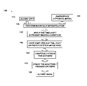
[0014] Figure 1 illustrates a seismic data processing flow in accordance with
one
particular aspect of the presently disclosed technique.
[0015] Figure 2 depicts selected portions of the hardware and software
architecture
of an exemplary computing apparatus on which that aspect of the presently
disclosed technique shown in Figure 1 may be performed.
[0016] Figure 3 graphically illustrates the execution of adaptive focusing and
the
conduct of weighted stacking first discussed relative to Figure 1.
[0017] Figure 4 illustrates one particular embodiment of the adaptive focusing
for the
process flow of Figure 1.
[0018] Figure 5A-Figure 5B graphically illustrate the efficacy of the data
processing
flow in Figure 1.
[0019] Figure 6 conceptually depicts the acquisition of the seismic data set
in one
particular embodiment.
3
CA 02939334 2016-08-11
WO 2015/157084
PCT/US2015/024099
[0020] Figure 7 illustrates one particular embodiment of the computing
apparatus of
Figure 2 as used in the embodiment of Figure 6 and which is, more
particularly, a
computing system on which some aspects of the present invention may be
practiced
in some embodiments.
[0021] Figure 8 graphs the variation of the weighting function cos(wt) in
Equation 4
with time lag at different frequencies.
[0022] Figure 9 is a rendering of a true velocity model.
[0023] Figure 10 is a rendering of a migration velocity model.
[0024] Figure 11 is a rendering of the difference between the migration
velocity
model shown in Figure 10 and the true model shown in Figure 9.
[0025] Figure 12 is a rendering of a conventional image produced with the
migration
velocity model shown in Figure 10 over the frequency band of 3-6-30-35 Hz.
[0026] Figure 13 is a rendering of a conventional image produced with the
migration
velocity model shown in Figure 10 over the frequency band of 3-6-20-25 Hz.
[0027] Figure 14 a rendering of an exemplary low frequency image extracted
from
the time-lag data by summing the two time-lag images at t= 8 ms.
[0028] Figure 15 is a rendering of a shot-indexed gather at x=8750 m for a
range of
depths located below salt.
[0029] Figure 16 is a rendering of a shot-indexed gather at x=8750 m for a
range of
depths located above salt.
[0030] Figure 17 is a rendering of the time lag picks at x=8750 m for the
range of
depths shown in Figure 15.
[0031] Figure 18 is a rendering of a weighted shot-indexed gather at x=8750 m
for
the range of depths shown in Figure 15.
[0032] Figure 19 is a rendering of an adaptively focused image. showing the
same
subsurface image points as in Figure 12.
DESCRIPTION OF THE EMBODIMENTS
[0033] The presently disclosed technique includes a method for improving
images
derived from seismic reflection data using an adaptive focusing approach that
automatically recognizes and removes short-wavelength time shift distortions
from
seismic data during conventional seismic migration calculations and adaptively
weights the image according to measures of its reliability. One application is
to
4
CA 02939334 2016-08-11
WO 2015/157084
PCT/US2015/024099
improving images below complex velocity overburden, particularly overburden
features that are deep in the subsurface of the Earth and are difficult to
characterize
by other means and are not well incorporated into the imaging velocity model.
However, the technique will find other applications, as will become apparent
to those
skilled in the art having the benefit of this disclosure.
[0034] The method operates inside an otherwise conventional seismic migration
algorithm by applying an extended imaging condition with a series of positive
and
negative time shifts, including zero (a zero time shift corresponding to the
conventional imaging condition), and preserving the migrated records without
stacking. If the different records have been migrated with an incorrect
velocity model,
the images will not align perfectly at zero time shift. In the invention, the
time-shifted
versions of each image point are compared to estimate a time shift at each
image
point and record that corrects for these image-alignment errors. Furthermore,
the
greater the required time shift, the greater the chance that the corrected
image
contribution from that trace is unreliable, in that it may not accurately
represent the
true reflectivity of the Earth but instead represents a coerced alignment of
noise or
true reflections from other image points. The resulting records can be summed
with a
weight that is greater for contributions with smaller time shifts and
decreases for
those with larger shifts, so that the contribution from unreliable parts of
the image to
the stack is reduced while preserving the reliable parts of the image.
[0035] More particularly, buried velocity anomalies that are very rapidly
spatially
varying are disruptive to seismic images. If one applies time shifts in the
imaging
condition during migration and leaves the image of each experiment unstacked,
they
can create a series of spatially and shot-variable time corrections that will
improve a
migrated image without knowing the correct velocity model. Furthermore, during
stacking the data can be weighted in some embodiments so as to reduce
unreliable
contributions to the stacked image. One way to judge the reliability of a
piece of data
is by how large a time shift is required to align it with a consensus stacked
image.
Data requiring a small or zero time shift is considered more reliable and is
stacked
with a larger weight than data requiring larger time shifts.
[0036] Reference will now be made in detail to the present embodiment(s)
(exemplary embodiments) of the invention, an example(s) of which is (are)
illustrated
in the accompanying drawings. Wherever possible, the same reference numbers
will
be used throughout the drawings to refer to the same or like parts.
CA 02939334 2016-08-11
WO 2015/157084
PCT/US2015/024099
[0037] Figure 1 illustrates a seismic data processing flow 100 in accordance
with one
particular aspect of the presently disclosed technique. This processing flow
100
operates on a set of seismic data 110 and a subsurface attribute model 120.
The
seismic data 110 may be acquired in conventional fashion. The subsurface
attribute
model 120 may be developed in conventional fashion.
[0038] More particularly, the seismic data 110 may be any kind of seismic data
known to the art. It may be, for example, data collected from a set of
hydrophones
"hydrophone" or "pressure" data) or from a set of geophones (i.e., "geophone"
or "Z" data). The seismic data may also be a combination of hydrophone and
geophone data known to the art as multicomponent data. The seismic data may be
acquired in a 1D, 2D, 3D, or 4D survey. The survey may be a land-based survey,
a
marine survey (either towed array or ocean bottom cable survey), or a survey
in a
transition zone. It may be what is known to the art as a "vertical seismic
profile". The
type of data and the kind of survey in which it is acquired are immaterial to
the
practice of the presently disclosed technique.
[0039] Similarly, the subsurface attribute model 120 may be any type of
subsurface
attribute model known to the art. For example, one tool frequently used in the
analysis of the seismic data is what is known as a "velocity model". A
velocity model
is a representation of the geological formation that can be used in analysis.
It may be
used to, for example, convert the seismic data into one or more "seismic
domains"
that image the geological formation in different ways. It may also be used in
other
ways to, for another example, analyze various geophysical characteristics of
the
formation. Other types of models of the underlying geological formations,
collectively
called "subsurface attribute models" herein, are also used and implicate
similar
considerations.
[0040] Those in the art having the benefit of this disclosure will also
appreciate that
the aspect of the presently disclosed technique illustrated in Figure 1 is
computer-
implemented. The seismic data 110 and the subsurface attribute model 120 are
both
sets of ordered, digital data residing in a non-transitory storage medium. The
seismic
data 110 is ordinarily sufficiently voluminous and the subsurface attribute
model 120
sufficiently complex that the computational requirements necessitate the use
of an
appropriately programmed computing apparatus.
[0041] Figure 2 conceptually depicts selected portions of the hardware and
software
architecture of a computing apparatus 200 such as may be employed in some
6
CA 02939334 2016-08-11
WO 2015/157084
PCT/US2015/024099
aspects of the present invention. The computing apparatus 200 may be a general
purpose computing apparatus or a dedicated computing apparatus depending upon
the particular implementation. The computing apparatus 200 includes at least a
processor 203 communicating with storage 206 over a communication medium 209.
[0042] The processor 203 may be any suitable processor or processor set known
to
the art. Those in the art will appreciate that some types of processors will
be
preferred in various embodiments depending on familiar implementation-specific
details. Factors such as processing power, speed, cost, and power consumption
are
commonly encountered in the design process and will be highly implementation
specific. Because of their ubiquity in the art, such factors will be easily
reconciled by
those skilled in the art having the benefit of this disclosure. Those in the
art having
the benefit of this disclosure will therefore appreciate that the processor
203 may
theoretically be an electronic micro-controller, an electronic controller, an
electronic
microprocessor, an electronic processor set, or an appropriately programmed
application specific integrated circuit ("ASIC"), field programmable gate
array
("FPGA"), or graphical processing units ("GPUs"). Some embodiments may even
use
some combination of these processor types.
[0043] Those in the art will also appreciate that data sets such as the
seismic data
110 are quite voluminous and that the processing described herein is
computationally intensive. Typical implementations for the processor 203
therefore
actually constitute multiple electronic processor sets spread across multiple
computing apparatuses working in concert. One such embodiment is discussed
below. These considerations affect the implementation of the storage 206 and
the
communication medium 209 similarly.
[0044] The storage 206 may include a magnetic hard disk and/or random access
memory ("RAM") and/or removable storage such as a floppy magnetic disk 212 and
an optical disk 215. The storage 206 is encoded with a number of software
components. These components include an operating system ("OS") 218; an
application 221; data structures including the seismic data ("SDATA") 110 and
the
subsurface attribute model ("SAMOD") 120. The storage 206 may be distributed
across multiple computing apparatuses as described above.
[0045] As with the processor 203, implementation-specific design constraints
may
influence the design of the storage 206 in any particular embodiment. For
example,
as noted above, the disclosed technique operates on voluminous data sets which
will
7
CA 02939334 2016-08-11
WO 2015/157084
PCT/US2015/024099
typically mitigate for various types of "mass" storage such as a redundant
array of
independent disks ("RAID"). Other types of mass storage are known to the art
and
may also be used in addition to or in lieu of a RAID. As with the processor
203, these
kinds of factors are commonplace in the design process and those skilled in
the art
having the benefit of this disclosure will be able to readily balance them in
light of
their implementation specific design constraints.
[0046] The processor 203 operates under the control of the OS 218 and executes
the application 221 over the communication medium 209. This process may be
initiated automatically, for example upon startup, or upon user command. User
command may be directly through a user interface. To that end, the computing
system 200 of the illustrated embodiment also employs a user interface 242.
[0047] The user interface 242 includes user interface software ("UIS") 245 and
a
display 240. It may also include peripheral input/output ('I/O") devices such
as a
keypad or keyboard 250, a mouse 255, or a joystick 260. These will be
implementation-specific details that are not germane to the presently
disclosed
technique. For example, some embodiments may forego peripheral I/O devices if
the
display 240 includes a touch screen. Accordingly, the presently disclosed
technique
admits wide variation in this aspect of the computing system 200 and any
conventional implementation known to the art may be used.
[0048] Furthermore, there is no requirement that the functionality of the
computing
system 200 described above be implemented as disclosed. For example, the
application 221 may be implemented in some other kind of software component,
such as a daemon or utility. The functionality of the application 221 need not
be
aggregated into a single component and may be distributed across two or more
components. Similarly, the data structures may be implemented using any
suitable
data structure known to the art.
[0049] As with the processor 203 and the storage 206, the implementation of
the
communications medium 209 will vary with the implementation. If the computing
system 200 is deployed on a single computing apparatus, the communications
medium 209 may be, for example, the bus system of that single computing
apparatus_ Or, if the computing system 200 is implemented across a plurality
of
networked computing apparatuses, then the communications medium 209 may
include a wired or wireless link between the computing apparatuses. Thus, the
implementation of the communications medium 209 will be highly dependent on
the
8
CA 02939334 2016-08-11
WO 2015/157084
PCT/US2015/024099
particular embodiment in ways that will be apparent to those skilled in the
art having
the benefit of this disclosure.
[0050] Some portions of the detailed descriptions herein are presented in
terms of a
software implemented process involving symbolic representations of operations
on
data bits within a memory in a computing system or a computing device. These
descriptions and representations are the means used by those in the art to
most
effectively convey the substance of their work to others skilled in the art.
The process
and operation require physical manipulations of physical quantities that will
physically transform the particular machine or system on which the
manipulations
are performed or on which the results are stored. Usually, though not
necessarily,
these quantities take the form of electrical, magnetic, or optical signals
capable of
being stored, transferred, combined, compared, and otherwise manipulated. It
has
proven convenient at times, principally for reasons of common usage, to refer
to
these signals as bits, values, elements, symbols, characters, terms, numbers,
or the
like.
[0051] It should be borne in mind, however, that all of these and similar
terms are to
be associated with the appropriate physical quantities and are merely
convenient
labels applied to these quantities. Unless specifically stated or otherwise as
may be
apparent, throughout the present disclosure, these descriptions refer to the
action
and processes of an electronic device, that manipulates and transforms data
represented as physical (electronic, magnetic, or optical) quantities within
some
electronic device's storage into other data similarly represented as physical
quantities within the storage, or in transmission or display devices.
Exemplary of the
terms denoting such a description are, without limitation, the terms
"processing,"
"computing," ''calculating," "determining," "displaying," and the like.
[0052] Furthermore, the execution of the software's functionality transforms
the
computing apparatus on which it is performed. For example, acquisition of data
will
physically alter the content of the storage, as will subsequent processing of
that data.
The physical alteration is a "physical transformation" in that it changes the
physical
state of the storage for the computing apparatus.
[0053] Note also that the software implemented aspects of the invention are
typically
encoded on some form of program storage medium or, alternatively, implemented
over some type of transmission medium. The program storage medium may be
magnetic (e.g., a floppy disk or a hard drive) or optical (e.g., a compact
disk read
9
only memory. or "CD ROM"), and may be read only or random access. Similarly,
the
transmission medium may be twisted wire pairs, coaxial cable, optical fiber,
or some
other suitable transmission medium known to the art. The invention is not
limited by
these aspects of any given implementation.
[0054] Returning now to Figure 1, the processing flow 100 begins by performing
(at
130) a wavefield extrapolation. This wavefield extrapolation (at 130) yields a
representation of the receiver side wavefield and the source side wavefield.
Extrapolation techniques of this type are well known to the art and any
suitable
wavefield extrapolation technique may be used. One exemplary, suitable
wavefield
extrapolation technique is the pseudo-analytical method (Etgen and Brandsberg-
Dahl, 2010), a time-
domain two-way extrapolation
technique. However, others including one-way depth-extrapolation techniques
such
as the F-X method may be used in various embodiments.
[0055] The process flow 100 then applies (at 140) the time-shift extended
imaging
condition to the extrapolated wavefields. This is also known as the time-lag
extended
imaging condition. One example of this technique is disclosed in P. Sava & S.
Fomel, "Time-Shift Imaging Condition in Seismic Migration" 71 Geophysics S209-
3217 (2006) ("Sava & Fomel"). Any
suitable
technique known to the art may he used.
[0056] The extended imaging condition generates data at different
crosscorrelation
lags, either in space or in time, which carries extra information about the
subsurface
indicating various degrees of velocity inaccuracy as shown in Sava & Fomel,
supra,
and P. Sava & I. Vasconcelos, "Extended Imaging Conditions for Wave-Equation
Migration", 59 Geophysical Prospecting 35-55 (2011) (Sava & Vasconcelos). In
conventional processes, this information can be used to drive velocity
inversion
processes as shown in P. Shen & W. W. Symes, "Automatic Velocity Analysis via
Shot Profile Migration", 73 Geophysics VE49¨VE59 (2008) (Shen & Symes) and in
T. Yang, & P. Sava, "Wave-Equation Migration Velocity Analysis with Time-Shift
Imaging", 59 Geophysical Prospecting 635-650 (2011) (Yang & Sava). However, in
the presently disclosed technique, it is directly used to identify image
degradations
and subsequently is employed to improve image quality without updating the
migration velocity model. More particularly, the presently disclosed technique
alleviates imaging artifacts caused by short wavelength velocity errors.
Date Recue/Date Received 2020-08-31
CA 02939334 2016-08-11
WO 2015/157084
PCT/US2015/024099
[0057] The process flow 100 then forms (at 150) a shot-indexed, time-lag
gather for
each image pixel of the subsurface attribute model 120. As those in the art
will
appreciate, an image pixel in such a model is a discrete node in the model at
which
the reflectivity is discretized. An exemplary rendering 300 of such a gather
at an
image pixel using synthetic data is shown in Figure 3, which illustrates the
efficacy of
the adaptive focusing technique disclosed herein. Note the lack of flatness
amongst
the traces in the gather 303 in this rendering 300. The shot-indexed, time-lag
gather
303, only one of which is indicated, in the rendering 300 may be determined
using
conventional techniques known to the art.
[0058] Conventionally the lags are calculated at discrete time steps of AT.
The
quantity L AT, where L is the integer lag, then is a time shift with units of
time, as
shown in the vertical axis in rendering 300. A lag of zero conventionally
corresponds
to a standard (non-extended) imaging condition. The time-shift extended
imaging
condition increases the dimensionality of the image by calculating an image
value at
each of a range of lags between the extrapolated source and receiver
wavefields,
thus generating an image at each depth point both as a function of shot index
and
lag, as shown in gather 303.
[0059] The process flow 100 then adaptively focuses (at 160) each gather,
e.g., the
shot-indexed, time-shift gather 303 in Figure 3. The adaptive focusing (at
160) for the
illustrated embodiment is shown in Figure 4. It begins by picking (at 400) a
respective optimal time lag for each of the traces in the gather.
[0060] Ideally the optimal time lag would measure the time offset between a
trace in
an extended-image gather calculated in the given velocity model (120) versus
the
same trace calculated the same way but using the true velocity model. As the
true
velocity model is only known in synthetic models, not in the real Earth, the
given
velocity model can only be an approximation for non-synthetic data, and the
optimal
time lag can only be estimated. When we pick an optimal time lag, we are
calculating
our best estimate of the time shift caused by the inaccuracies and limitations
of our
given velocity model.
[0061] There are many ways of doing this known to the art. For example, the
lag
containing the peak amplitude could be picked for each trace in the gather. In
this
particular embodiment, the traces in the gather are stacked to create a
consensus
trace, and then the lag corresponding to the peak cross correlation between
each
11
CA 02939334 2016-08-11
WO 2015/157084
PCT/US2015/024099
trace in the gather and the consensus trace is picked as the lag that best
measures
the time shift of each trace with respect to the consensus.
[0062] Note that the time shifts 306, only one of which is indicated, may vary
without
discernible pattern within a gather, as shown in the rendering 310 in Figure
3. Many
variations will be apparent to those skilled in the art. A weighted sum or
median
stack could be used to create the consensus trace. The traces could be
interpolated
to allow a non-integer lag to be determined. The consensus trace could be low-
pass
filtered or otherwise processed. In any case, the optimal lag for each trace
is
multiplied by AT to determine the corresponding time-shift that optimally
aligns each
trace in the gather with the consensus trace.
[0063] These time shifts are then applied (at 410) to the gathers. The
rendering 320
in Figure 3 illustrates the application of the time shifts 306 shown in the
rendering
310 to the gather 303 of the rendering 300. Note how the application of the
time
shifts 306 flattens the traces in the gather 303 in the rendering 320 and
moves the
peak energy in each trace to near the central time shift of zero.
[0064] This particular embodiment is designed to also suppress noise in the
seismic
record. A significantly large time shift 306 will generally be presumed to
indicate that
the respective trace of the corresponding gather 303 is more likely to be
untrustworthy, because the large time shift indicates that there are
inconsistencies in
the velocity model used to migrate that trace. Significantly large time shifts
306 can
therefore be used to identify parts of the common-depth-point gather that are
more
likely to be erroneous. Accordingly, as shown in Figure 4, the adaptive
focusing (at
160) in this particular embodiment includes an optional weighting (at 420) for
each of
the traces in gather 303. This weighting is then used in stacking the gathers
as
described further below.
[0065] The weighting may vary greatly across various implementations of this
particular embodiment. The weighting may be as simple as a "1" or a "0"
indicating
whether to include or omit the particular trace from the stacking.
Alternatively, the
weighting may be inversely proportional to the magnitude of the time lag added
to a
constant (so that the weight at zero lag does not become infinite). Or the
weighting
may be arrived at through the application of some mathematical function that
is
largest at zero lag and decreases for lags of larger magnitude. The weighting
function will be data dependent and should act to increase the weight of
reliable
12
CA 02939334 2016-08-11
WO 2015/157084
PCT/US2015/024099
traces and decrease the weight of unreliable traces. The weighting may also be
omitted altogether in some embodiments.
[0066] Note that these weights may be output as an auxiliary data product
useful for
interpretation, indicating which parts of the image the human interpreter may
rely on
and which should be treated with suspicion. The full volume of weights may
have
more dimensions than are easily interpretable, and thus the interpreter may
choose
to instead consult a volume that has been projected to reduce its number of
dimensions. Many ways of doing this are known to the art. For example, the
average
or median weight applied to the traces making up each common-depth-point
gather
might be output at each common depth point. This projected volume would have
the
same dimensionality as the stacked image.
[0067] What constitutes a 'significant" or "large' time lag will be a
consideration of
implementation-specific factors such as will become apparent to those skilled
in the
art having the benefit of this disclosure. Exemplary factors include the type
of
imaging to be performed, the purpose for which the image will be used, the
deviation
of the time lag magnitudes, and the overall level of noise in the seismic
record. Not
all of these considerations will be used in each embodiment. Indeed, some
embodiments may omit these considerations entirely and/or use others in lieu
or in
addition to these. The list is merely exemplary and is not exhaustive.
[0068] Returning now to Figure 1, the adaptive focusing (at 160) is followed
by a
stacking (at 170) of the adaptively focused gathers. This particular
embodiment
weights the gathers during the adaptive focusing, see Figure 4, and so this is
a
weighted stacking in this embodiment. (It follows that, in embodiments that
omit the
weighting during the adaptive focusing, the stacking here may be unweighted.)
As
discussed above, the gathers are weighted differently depending on the amount
of
error they are estimated to contain. High error (i.e., large time lag) gathers
consequently are either omitted or de-emphasized. In this way, this particular
embodiment mitigates errors in the image. Conventional stacking techniques may
be
used to perform this stacking.
[0069] Figure 5A-Figure 5B illustrate the effect of the adaptive focusing as
described
above on the gather 303 first shown in the rendering 300 in Figure 3. More
particularly, Figure 5A depicts a stack of the gather of traces 303 without
the
adaptive focusing taught above. Figure 5B depicts a stack of those same traces
303
stacked after application of the adaptive focusing technique, yielding a time-
shift
13
CA 02939334 2016-08-11
WO 2015/157084
PCT/US2015/024099
trace that has a strong amplitude at time zero, which will be extracted as the
image
at this particular location. Figure 5A, in comparison, has less energy at time
zero due
to time shifting of the reflection energy in the shot-indexed traces away from
time
zero, caused by inaccuracies in the velocity model above this image point.
[0070] The stacked, adaptively focused gathers are then used to image (at 180)
the
subterranean formation of which the seismic data is representative. Those in
the art
having the benefit of this disclosure will appreciate that there are many ways
in
which stacked gathers may be used to image. The stacked, adaptively focused
gathers generated as disclosed above may be used in any conventional imaging
process in the same manner as stacked gathers that have not been adaptively
focused. That is, the type and manner of the imaging is not material to the
practice of
the technique.
[0071] Thus, the presently disclosed technique applies the extended imaging
condition and the adaptive focusing to identify and mitigate image
degradations,
especially those arising from short wavelength velocity errors, while relying
on
velocity estimation tools to accurately provide the long and intermediate
wavelength
components of a subsurface attribute or velocity model (such as at 120). One
positive consequence of this technique, then, is that it can improve image
quality
without requiring an update of the migration velocity model. Still other
advantages,
uses, and benefits will become apparent to those skilled in the art having the
benefit
of this disclosure.
[0072] Those in the art will appreciate that the adaptive focusing technique
disclosed
above is a part of a larger process. This larger process stretches from
acquisition of
the seismic data 110 through its pre-processing and processing to the
analysis,
including the adaptive focusing, of the processed data. To further an
understanding
of the presently disclosed technique, this larger process will now be
disclosed in one
particular embodiment. However, in the discussion below, synthetic data rather
than
real world data is used.
[0073] Referring now to Figure 6, the acquisition 600 is performed in a
conventional
ocean bottom survey in this particular case. A tow vessel 601 tows one or more
conventional sources 603 that may be, for example, airguns or swept-frequency
sources such as are known in the art, on the water's surface 606. The
source(s) 603
impart one or more seismic signals 609 into the water column 610 to penetrate
the
seabed 611 and where they are reflected by a subterranean reflector 612.
14
CA 02939334 2016-08-11
WO 2015/157084
PCT/US2015/024099
[0074] The reflections 615 then propagate back to the receiver array 618 on
the
seabed 611. The receiver array 618 includes a plurality of receivers 621 (only
one
indicated). The receivers 621 themselves could be hydrophones, geophones, or
multicomponent nodes depending on the implementation. The reflections 615 are
detected by the receivers 621 and recorded as the seismic data 110. The
recorded
seismic data 110 are then communicated to a computing facility 624. This
communication may be, for example, by hard copy on a magnetic tape 627 or by
transmission via a satellite 630. The computing facility 624 houses a
computing
system by which the seismic data 110 are processed as described.
[0075] A portion of an exemplary computing system 700 by which such processing
occurs in this embodiment is shown in Figure 7. The computing system 700 is
networked, but there is no requirement that the computing system 700 be
networked.
Alternative embodiments may employ, for instance, a peer-to-peer architecture
or
some hybrid of a peer-to-peer and client/server architecture. The size and
geographic scope of the computing system 700 is not material to the practice
of the
invention. The size and scope may range anywhere from just a few machines of a
Local Area Network ("LAN") located in the same room to many hundreds or
thousands of machines globally distributed in an enterprise computing system.
[0076] The computing system 700 comprises, in the illustrated portion, a
server 710,
a mass storage device 720, and a workstation 730. Each of these components may
be implemented in their hardware in conventional fashion. Alternative
embodiments
may also vary in the computing apparatuses used to implement the computing
system 700. Those in the art will furthermore appreciate that the computing
system
700, and even that portion of it that is shown, will be much more complex.
However,
such detail is conventional and shall not be shown or discussed to avoid
obscuring
the subject matter claimed below.
[0077] In Figure 7, the application 221 is shown residing on the server 710
while the
seismic data 110 and subsurface attribute model 120 reside in the mass storage
720. While this is one way to locate the various software components, the
technique
is not dependent upon such an arrangement. Although performance concerns may
mitigate for certain locations in particular embodiments, the situs of the
software
components is otherwise immaterial.
[0078] The seismic data 110, in this particular embodiment, is multicomponent
OBC
data including both hydrophone and geophone data. The processing of the
seismic
CA 02939334 2016-08-11
WO 2015/157084
PCT/US2015/024099
data 110 customarily begins with a variety of pre-processing steps known to
those of
ordinary skill in the art such as conversion of data formats, time windowing,
discarding noisy traces, associating navigation information with each data
trace,
removing the source signature, deconvolution, muting, etc.
[0079] The process flow 100 of Figure 1 is then implemented in an adaptive
image
focusing, automated workflow that, in this particular embodiment, extracts
improved
imaging results from imperfect migration velocity models. It involves
amplitude
balancing and alignment to directly construct improved gathers and noise
suppression to remove destructive energy from the stack. This particular
embodiment also employs the weighted gathering of the adaptively focused
wavefields disclosed above to identify and suppress non-contributing shot-
record
migration results in the time-lag extended image domain.
[ono] The process applies the extended imaging condition (at 140) to the
wavefields
extrapolated (at 130) from the seismic data 110 and the subsurface attribute
model
120. The subsurface attribute model 120 is, in this particular embodiment, a
velocity
model. As noted above, the extended imaging condition generates data at
different
crosscorrelation lags, either in space or in time, which carry extra
information of the
subsurface indicating various degrees of velocity inaccuracy. Sava & Fomel
define
the extended imaging condition as:
(x, s, = D*(x,s,w)U(x,s,w)ei"
(1)
where I represents the extended image at time lag T for shot s, and D and U
are the
source and receiver wavefield, respectively. The corresponding time domain
formula
can be expressed as:
/ (X, S, = D* (x, s, t ¨ U (x, s, t + ¨T)
2 2 (2)
[0081] The conventional image corresponds to a stack over shots at zero time
lag,
i.e.,
/o(x) = / (x, s. = 0)
(3)
This indiscriminate summation of conventional imaging in equation 3 does not
take
into account the high variability of contributions from individual shots in
the subsalt
environment due to velocity uncertainties. To obtain auto-focused images, the
technique starts from the individual extended-image shot-migration results of
16
CA 02939334 2016-08-11
WO 2015/157084
PCT/US2015/024099
equations 1 or 2. It then searches for optimized stacking lags and weights in
the
extended image domain.
[0082] The extrapolated wavefield exhibits a frequency-dependent sensitivity
to the
migration model. The low frequency component is relatively less sensitive to
short
wavelength velocity errors and thus more reliably reveals the subsurface
structure.
For this reason, one may use the low frequency response as a guide to improve
image quality at higher frequencies. A low frequency image can be constructed
using
frequency- domain migration codes through selective summation over low
frequencies in Equation 1. This frequency-domain methodology does not incur
any
significant extra computations in the migration. In comparison, time-domain
codes
seem to require a separate migration run to obtain the low-frequency response.
However, this is in fact unnecessary because one can extract the required low-
frequency information from the extended images.
[0083] One possibility is to sum two extended images with opposite time lags
as
follows:
/21, (x, s) = (x, s, TLF) + /(x, s, ¨TLF) = 2 / D* (x, s, co) U (x, s, co) cos
cot- is
(4)
which essentially yields a low-pass-filtered image, because as shown in
equation 4
the effect of the summation is to weight the image at frequency 0.) by cos
WTLF= The
choice of time shift TLF depends on the desired frequency content, as is
illustrated in
Figure 8, which shows the relationship between TLF and the weighting term cos
coTLF
for various frequencies.
[0084] The similarity of the extended image /(x, s, T) and the low-frequency
image
/r,õ(x,$) is measured for a range of trial time lags '1, and the time lag
t(x,$) where the
maximum similarity is located for each subsurface location x and shot index s
is
then recorded. Non-zero time lags indicate velocity errors have caused certain
distortions to the zero-lag image. Reflection energy shifted away from time
zero does
not contribute in conventional stacking (Equation 3) because only energy at
lag of
zero is included in the final stacked image. By using the calculated time
shifts to first
correct the time (410), the misplaced energy contributes to the final stack.
[0085] An improved image can then be obtained through weighted stacking over
shots,
17
CA 02939334 2016-08-11
WO 2015/157084
PCT/US2015/024099
(x, s) = /(x, s)w(x, s)
(5)
a procedure similar to the optimal stacking M. Vyas & A. Sharma, 2012,
"Optimal
stacking", 82nd Annual Meeting, SEG, Expanded Abstracts, 1-5 (2012) (Vyas &
Sharma). One choice of weighting function is w(x,$) cc
'
[0086] A similarity matching procedure for seismic data will contain some
uncertainty.
Some ambiguities in the time-lag picking process will therefore remain. One
solution
is to perform a further stacking of the images from different time lag picks:
/(x) = /w(x)
(6)
This works well if the time-lag picking errors are random, which one could
achieve by
using different similarity matching algorithms or intentionally introducing
proper
randomness into the selected similarity matching method.
[0087] Figure 9 displays part of the benchmark model published in Billette, F.
& S.
Brandsberg-Dahl, "The 2004 BP velocity benchmark: 67th Annual Conference and
Exhibition", EAGE, Extended Abstracts, B305 (2005) that will be used in this
illustration of how the velocity errors around the salt body would affect the
image
quality. The illustration actually uses a slightly modified version of the
original model
as the migration velocity model. The modified model is shown in Figure 10. The
difference between this modified model and the original model is shown in
Figure 11.
This difference is representative of the sorts of errors that happen in
practice when
velocity models are constructed to represent the true velocity structure of
the Earth.
In particular, these errors commonly occur when analyzing data from the Gulf
of
Mexico. Determining the fine details of the structure of the top and bottom of
salt is
an unsolved challenge.
[0088] A full-frequency wave-equation migration result, i.e. a conventional
stacked
image, for the sub-salt area is given in Figure 12. Due to inaccuracies in the
migration velocity model, this image contains a significant amount of
artifacts. Low
frequency data are less sensitive to the velocity inaccuracies, as is
demonstrated in
Figure 13, a low-frequency migrated image corresponding to the same image
shown
in Figure 12. Figure 13 lacks the resolution exhibited in Figure 12 but
appears
cleaner and better focused. A similar low frequency image can also be
extracted
from the time-lag data, as explained by Equation 4. An example is given in
Figure
18
CA 02939334 2016-08-11
WO 2015/157084
PCT/US2015/024099
14, which was produced by summing the two time-lag images at T=8 ms and T=-8
ms.
[0089] Examination of the artifacts reveals that Figure 13 is slightly better
than Figure
14 but the two figures for practical purposes are the same. The presently
disclosed
technique uses time-lag images to construct the low-frequency responses as
this
approach has a significant cost benefit for time-domain migrations. Such low-
frequency images from each shot will be used in the search for optimal time
lags to
focus the image (400). Ideally, "optimal time lags" are those that, when used
to time
shift unstacked extended-image gathers, would result in the energy in the
traces
moving to where it would have been if the velocity model above that image
point had
been correct. For real data, we do not know the true velocity model, and
optimal time
lags can at best only be estimated by comparing extended images of the same
common image point from different shots.
[0090] The artifacts can also be observed in the unstacked shot-indexed gather
in
Figure 15. (I.e., if we stack Figure 15 over the horizontal shot index axis,
we would
create one vertical trace in Figure 12.) If the velocity model were accurate,
we would
expect to create a similar image from each shot, and the figure would show
horizontal stripes. By comparing Figure 15 to the unstacked shot-indexed
gather for
a range of depths in the sediments above the salt, shown in Figure 16, which
does
show the expected horizontal stripes, we can see that the velocity errors
around the
salt body caused substantial distortions to the sub-salt gather in Figure 15.
The
interest is to differentiate signal from noise using these gathers by
adaptively
quantifying the similarity between the time-lag images and the low frequency
image,
also extracted from the time-lag data. An example of the magnitude of the time-
lag
picks corresponding to the maximum similarity for each depth and shot at this
horizontal position in this 2D model is shown in Figure 17.
[0091] Large time lags in general coincide with seemingly destructive energies
on the
corresponding shot-index gather shown in Figure 15. This particular embodiment
then applies a weighting derived from the time lag picks to the shot-indexed
gathers.
Figure 18 shows the results of applying these weights to the shot-indexed
gather in
Figure 15. Unreliable portions of the gather have been weighted down. A stack
of the
weighted shot-indexed gathers produces an improved image with the major events
being notably enhanced and the artifacts being significantly suppressed.
19
[0092] As will be clear to those of ordinary skill in the art, this process of
creating an
improved image can be iterated. The weighted stack then becomes the new
consensus image, and new time shifts and weights can be calculated by
comparing
extended-image gathers to consensus traces taken from the new consensus image.
This process of calculating optimal time shifts, stacking, and filtering to
create a low
frequency filtered image (or summing two or more time lags to create a low
frequency image as in Figure 14) may be repeated until convergence or as
desired.
As the stacked image quality improves with each iteration, the maximum
frequency
allowed in the low-frequency consensus traces may be increased.
[0093] In particular, at each common depth point the degree of low-pass
filtering may
be varied depending on the consensus reliability of the extended-image gather
traces being stacked there, such that the bandwidth of the image naturally
increases
the more reliable the image. Figure 19 shows the result of such an iterated
image
improvement. Comparing Figure 19 with Figure 12, we can see that it has
enhanced
the image without sacrificing resolution, as in Figures 13 and 14.
[0094] The extended imaging condition provides the opportunity to detect the
velocity
errors and it may also be used to at least partially compensate for these
errors to
improve the image quality, which can be realized through similarity matching
and
weighted stacking as we have demonstrated using time-lag images for a
synthetic
dataset. This approach is fully automated and is completely data driven. The
shot-
indexed gather is a good choice for shot-record migrations. Those of ordinary
skill in
the art will readily appreciate that other types of gathers can certainly be
employed
using the method of this invention.
[0095]
[0096] Etgen, J. T., and Brandsberg-Dahl, S., "Pseudo-analytical method for
the
solution of wave equations", U.S. Application Serial No. 12/574,529, filed
October 6,
2009, and published April 8, 2010, as US Patent Publication 2010/0088035
(2010),
for its teachings regarding methods for extrapolating wavefields in time.
[0097] Sava, P., and S. Fomel, "Time-Shift Imaging Condition in Seismic
Migration"
71 Geophysics S209¨S217 (2006), for its teachings regarding the time-shift
extended imaging condition.
[0098] M. Vyas & A. Sharma, "Optimal Stacking", 82nd Annual Meeting, SEG,
Expanded Abstracts, 1-5 (2012), for its teachings regarding the stacking of
gathers.
Date Recue/Date Received 2020-08-31
[0099]
[00100] Other embodiments of the invention will be apparent to those skilled
in the art
from consideration of the specification and practice of the invention
disclosed herein.
It is intended that the specification and examples be considered as exemplary
only,
with a true scope and spirit of the invention being indicated by the following
claims.
21
Date Recue/Date Received 2020-08-31