Note : Les descriptions sont présentées dans la langue officielle dans laquelle elles ont été soumises.
CA 02940652 2016-08-24
WO 2015/130950
PCT/US2015/017787
An Improved Performance and Cost Global Navigation Satellite
System Architecture
This application claims the benefit of U.S. Provisional Patent Appl. Ser. No.
61/944,752, filed February 26, 2014.
Background of the Invention
The United States Global Positioning System (GPS) satellite constellation is
an
enormous success, offering reliable, three-dimensional, real-time positioning
to
users on a global basis. Its breadth of use is vast, encompassing military,
civil, and
commercial applications. Other nations are emulating the success of GPS by
implementing their own satellite constellations. These include the Russian
GLONASS, Chinese Beidou, European Galileo, and the regional Japanese QZSS and
Indian IRNSS. Collectively, such satellite systems are known as Global
Navigation
Satellite Systems (GNSS).
Nevertheless, several issues frustrate advancement in that there are technical
opportunities for significantly improved performance and capability provided
by
GNSS. These issues relate to (i) rapid acquisition of accuracy and integrity
for
transportation applications, (ii) military availability of GPS, and (iii)
radio frequency
spectrum crowding. At the same time, there is increased pressure for return on
investment both in the public and private sectors. Concerns also relate to the
susceptibility of GNSS to interference and tampering, including jamming,
spoofing,
and proof of position.
The Federal Aviation Administration (FAA) is leading a transformation of the
nation's air traffic system into a new initiative called NextGen, emphasizing
satellite-
based Navigation and Automatic Dependent Surveillance¨Broadcast (ADS-B).
1
CA 02940652 2016-08-24
WO 2015/130950
PCT/US2015/017787
Europeans and other countries are embarking on similar modernization. However,
despite the enormous benefits of increased capacity brought to aviation and
the
National Airspace (NAS) by GPS, several concerns about potential
vulnerabilities
remain, in particular, that of interference¨either intentional or
unintentional.
While the capabilities of GPS are significant, the system has a very low
broadcast
power. Even a 1-Watt jammer in the GPS band in the vicinity of an airport
terminal
area could cause major disruption. There is also a spoofing and tampering
concern.
In this scenario, a malevolent party would attempt to introduce misleading
signals
to make controllers think that aircraft are in a different place than they
really are,
possibly causing harm to people and/or property.
Another tampering-related concern is the increasing demand for Unmanned Aerial
Systems (UAS) in the NAS, particularly commercial UAS. Military UAS can carry
receiver equipment that employs the military encrypted GPS broadcast, thereby
protecting against spoofing. Commercial UAS users are ineligible to integrate
such
controlled equipment and are therefore more vulnerable to spoofing. In
aircraft
surveillance, aircraft also need to reliably prove their position to third
parties.
Additional vulnerabilities can arise under these circumstances.
Much of the potential cost savings that has been intended with ADS-B through
the
phase-out of legacy Secondary Surveillance Radar (SSR) may not materialize for
decades due to the concern over interference. It may take that long to
accumulate
the operational experience and confidence to retire legacy navigation aids. In
the
meantime, the FAA is pursuing an Alternate Position, Navigation, and Timing
(APNT) program that would implement a backup means of positioning independent
of GPS. Unfortunately, the costs associated with carrying the legacy SSR
system, the
new GPS-based ADS-B system, plus a new backup APNT system may become
significant.
2
CA 02940652 2016-08-24
WO 2015/130950
PCT/US2015/017787
The cost of navigation and surveillance infrastructure is significant,
typically borne
by the Air Navigation Service Provider (ANSP)¨the FAA in the case of the
United
States. Also significant are costs of avionics on board the aircraft, paid for
by the
aircraft owner or user. Insertion costs of a new capability must be justified
by their
benefits or there will be no incentive to move ahead in air traffic management
modernization. This is especially true in the case of a retrofit. Given that
the typical
aircraft operational lifetime is 30 years of service with the same initial
suite of
avionics, the time constant of innovation can be long.
What are needed are new protections to GPS and GNSS increasing the resiliency
to
unintentional interference, jamming, and spoofing. What is also needed is a
means
to quickly localize and disable interference emitters. Aircraft need to carry
protections against interference when it is happening, and the ground
capability
needs to be able to respond in a timely manner to minimize the duration of any
disruption. Furthermore, insertion of the new protections ideally needs to
require
minimal changes to aircraft avionics. Such new protections should require
little, if
any, change-out of avionics hardware.
Integrity is a positioning system's knowledge that it is outputting non-
hazardous
information. What would also be beneficial to aviation is applying new
accuracy and
integrity capability to a better-protected, more resilient GPS to achieve
lower
landing minima using satellites. The FAA Wide Area Augmentation (WAAS) System
is designed to ultimately enable aircraft to land to a visibility down to a
200 ft
decision height. Improved GNSS accuracy, integrity, and interference
resilience
could enable GNSS to be used for autoland and conditions of zero visibility.
The end
result would be more safe, on-time arrivals in worse weather conditions at
more
airports worldwide all for lower cost.
Intelligent automobile transportation can also benefit from improved GNSS
functionality¨especially when integrated with a vehicle-to-vehicle (V2V) data
link
3
CA 02940652 2016-08-24
WO 2015/130950
PCT/US2015/017787
to exchange precise position information. In accident avoidance and where-in-
lane
driverless car applications, a sensor needs to provide dependable, centimeter-
level
position information. Position sensors, including cameras, Inertial
Measurement
Units (IMUs), RADAR, and LIDAR, are based on a variety of physical principles.
Every sensor has its strengths and weaknesses in terms of operating
environment.
Practical systems integration must be conscious of cost and should also employ
a
diversity of sensors to achieve an overall robust solution.
Cameras are low cost but are subject to blockage, errors in computer-based
scene
interpretation, and degradation under low visibility conditions, such as fog,
rain,
and snow. RADAR is also low cost and operates in all weather conditions, but
does
not provide complete situational awareness. RADAR requires line of sight in
its
directions of use and may be blocked by other vehicles or obstacles. IMUs¨
especially Micro-Electro-Mechanical Systems (MEMS)¨can be made low cost and
provide excellent short-term precision. However, IMUs are subject to drift and
must
be calibrated continuously by an independent source of positioning. LIDAR
provides comprehensive situational awareness, but remains costly for the time
being. Furthermore, LIDAR is subject to degradation under poor visibility
conditions. Lastly, the above positioning sensors generally do not possess
intrinsic
means for deriving integrity.
What is needed is a reliable means for fusion of diverse sensor types and a
means to
reliably improve GNSS to the centimeter-level under challenging environmental
conditions, including poor visibility and radio frequency interference, with
built-in,
safety-of-life-class integrity that converges to an operational status from a
cold start
within a few tens of seconds. Of all the candidate automobile sensors, only
GNSS is
able to provide absolute position accuracy, i.e., relative to an Earth-fixed
coordinate
system. Such a robust positioning capability including both accuracy and
integrity
would also be beneficial to real-time map maintenance and IMU calibration.
4
CA 02940652 2016-08-24
WO 2015/130950
PCT/US2015/017787
The military is also concerned with GPS modernization. However, the military
does
not generally have an accuracy or integrity requirement for most missions. The
military does, however, have a need for increased availability under blockage
conditions, including urban canyons and mountainous conditions. What is needed
is
a cost-effective means of increasing the number of military space-based
positioning,
navigation, and timing (PNT) ranging sources accessible to users.
The military is also facing significantly increased costs in attempting to
increase GPS
signal power. The large-diameter, deployable antennas contemplated for use in
Medium Earth Orbit (MEO) are challenging to manufacture and expensive. What is
needed is an approach to increasing the power of military space-based PNT that
costs less.
Agriculture, survey, and offshore applications currently use aiding networks
such as
OmniSTAR, StarFire, and Veripos to GPS for global, sub-decimeter precision
navigation. However, these systems are not designed to provide integrity to
suppress bad position fixes. They can also take as long as 45 minutes to
converge
from a cold start. Offshore users also need resilient coverage, especially for
critical
services like dynamic platform positioning. What is needed is a means of
accelerating startup time, expanding to true global coverage, and providing
new
avenues for resiliency.
GPS Modernization has led to the introduction of a third civil frequency.
Proponents
of the third civil frequency argue that it will allow ionosphere estimation
and rapid
cycle ambiguity resolution across long baselines [Reference 1]. Unfortunately,
such
an approach introduces issues, including navigation that does not degrade
gracefully in the presence of faults or rare normal conditions. Furthermore,
introduction of the new frequencies is planned to take several years before a
full
GPS constellation is operational.
5
CA 02940652 2016-08-24
WO 2015/130950
PCT/US2015/017787
Three prior art inventions [References 2 through 4] employ constellations of
Low
Earth Orbit (LEO) satellites, including Iridium and Globalstar, to provide
increased
accuracy performance. These inventions advanced the art but nevertheless have
presented practical obstacles in attempts at actual implementation. In the
nearly
two decades since the referenced applications were filed, the applicants are
not
aware of any operational or planned embodiments.
The United States Navy, working with contractors Boeing, Iridium, Rockwell
Collins,
and Coherent Navigation, has developed a system [References 5 and 6] that
employs
Iridium as a means of improving GPS jamming resistance for military purposes.
This system uses aiding from the Iridium constellation and coherent detection
to
improve the jamming resistance applicable to ordinary GPS receivers. While
such
an approach for interference rejection may be beneficial for certain specific
applications, in a broader context it requires dedicated new user equipment
components to operate in a new band at power levels that are not consistent
with
the existing GPS system design. What is needed is an even more practical means
to
bring about interference rejection in high-accuracy and integrity, cost-
sensitive
GNSS applications.
The FAA WAAS provides accuracy of a few meters and safety-of-life integrity
for
precision approach and landing¨ultimately by design down to a 200 ft decision
height. However, its design does not fare well under interference. For
example,
even a small amount of jamming can cut off the data messages that are the
underpinning of the WAAS. This means that alerts and differential corrections
are
unavailable. Furthermore, GNSS ranging measurements are also degraded or lost
during interference. What is needed is improved resilience to interference for
civil
and commercial transportation users in a practical way with a minimum of
hardware changes.
6
CA 02940652 2016-08-24
WO 2015/130950
PCT/US2015/017787
Spectrum is an emerging issue in PNT. Recent efforts have sought to establish
a
broadband network in the band adjacent to GPS. Front-end radio frequency
filters
in the installed base of tens of millions of GPS receivers assume a power
level in that
adjacent band understood to be significantly less than the new proposed plans.
Current trends are evolving towards increased spectrum management necessitate
the de-confliction of applications. Especially for safety-of-life
applications, such as
aviation and automobiles, what is needed is a timely technical approach to
space-
based PNT architecture that is efficient with spectrum and is able to co-exist
safely
without degradation with broadband applications running in adjacent bands.
From a military perspective, a requested extensions to GPS that would add spot
beams to the satellites have not been funded. Furthermore, there is growing
DoD
interest in increasing the number of GPS satellites to 30 from the current
requirement of 24 to improve availability due to masking. What is needed is
new
military performance, including high mask angle visibility and continuous
regional
high power that can be affordably implemented in the near-term.
Summary of the Invention
The invention provides improved, worldwide GNSS performance with protections
against interference and tampering that is cost effective. The broadcast in
the GNSS
band is compatible with existing user equipment based on typically only a
software
change. An early application of the data and precise ranging signal is next
generation of transportation mobility, including aviation navigation and
surveillance and automobile accident avoidance and where-in-lane positioning.
For
automobiles, requirements include centimeter-level accuracy, safety-of-life
integrity
of a 1m Alert Limit and vanishing probability of hazardously misleading
information
per exposure, and a cold-start acquisition time of a few tens of seconds. To
properly
introduce the era of the automobile autopilot, guidance must be impeccably
reliable
and ubiquitous. The high integrity capability also applies to military
applications,
including carrier landing of manned and unmanned aircraft as well as formation
7
CA 02940652 2016-08-24
WO 2015/130950
PCT/US2015/017787
flight. For military applications, additional GNSS availability at higher mask
angles
and higher power are also provided. And for heavy machine control, including
agriculture, survey, mining, and offshore applications, rapid convergence of
accuracy is provided.
The solution is based on carrier phase and coherent detection, thereby
providing
high precision. Such coherent detection is leveraged as the basis for
accuracy,
integrity, and interference rejection. The invention uses a LEO constellation
to
provide users with rapid angle motion and favorable geometry globally at all
times.
The rapid angle motion helps to convert precision to accuracy, achieve safety-
of-life
level integrity, and rapid cold-start convergence. Integrity is provided
mostly
through Receiver Autonomous Integrity Monitoring (RAIM). The combination of
carrier phase precision, rapid angle motion, and the practical system
architecture
described herein take RAIM to a new level of performance.
From statistics reported on the Department of Transportation (DOT) ITS
website,
enabling increased accident prevention and driverless cars, improved
transportation systems can potentially save thousands of lives and billions of
gallons of gasoline each year. The invention provides its navigation accuracy
and
integrity performance at low cost. Because the invention requires only narrow
band
carrier phase, code spreading is no longer needed explicitly for timing and
ranging.
Therefore, only a minimum spectrum bandwidth is needed for GNSS¨theoretically
less than 100 kHz. Civil GNSS can co-exist with high-power broadband, thereby
making valuable spectrum more accessible.
The invention also applies Public Key Infrastructure (PKI) and networking
principles to the LEO satellites to enables them to be used securely with any
defined
GNSS code. Similar techniques can be used for civil purposes to provide a
civil
authentication overlay to GPS. The invention introduces a watermark and
special
data in the signal that can be independently verified and cross-checked with
the
8
CA 02940652 2016-08-24
WO 2015/130950
PCT/US2015/017787
RAIM integrity solution. Such an overlay can provide comprehensive checking
with
tight thresholds for existing aviation receivers and new UAS receivers so as
to be
operational within just a few years. No changes to the GPS constellation are
required.
By also providing a platform for broadband sampling registered in time and
space,
the invention also provides a means for geolocating spurious emitters.
Therefore,
any scenario is covered. The user equipment works to defeat interference and
spoofing in real time such that operations can continue. In the meantime, the
invention provides timely information leading to the source of the
interference,
thereby speeding takedown time and return to normal operations. Both military
and civil applications are viable. The invention operates on arbitrary
waveforms.
The rapid angle motion even works with narrowband emitters whose cycle
ambiguities otherwise introduce cycle ambiguities.
Brief Description of the Drawings
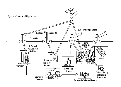
Figure 1 shows the concept of operations (CONOPS) of the overall system.
Figure 2 shows the SurePointTM satellite payload architecture.
Figure 3 shows the transmit/receive module for the satellite payload.
Figure 4 shows the payload baseband functional architecture.
Figure 5 shows the physical configuration of a stand-alone satellite.
Figure 6 shows satellite reference design evolution.
Figure 7 shows the physical LEO broadcast geometry.
9
CA 02940652 2016-08-24
WO 2015/130950
PCT/US2015/017787
Figure 8 shows the global coverage provided by the baseline constellation.
Figure 9 shows the integrated GNSS-LEO geometry.
Figure 10 shows an example of code re-use in the constellation.
Figure 11 shows the constellation single-launch configuration.
Figure 12 depicts sequenced deployment of multiple satellites designed to
preclude
re-contact.
Figure 13 shows deployment phased by orbit plane for the single-launch
insertion.
Figure 14 illustrates the service data processing function.
Figure 15 shows the user equipment hardware.
Figure 16 shows the receiver navigation processing architecture.
Figure 17 shows an example approximating the availability of integrity for
users.
Figure 18 shows the sensor fusion function providing safe scaling with
integrity.
Figure 19 shows improvements in interference rejection achieved with the
system.
Figure 20 shows the broadband spectrum adjacent to GPS.
Figure 21 shows the civil transportation system of systems.
CA 02940652 2016-08-24
WO 2015/130950
PCT/US2015/017787
Figure 22 shows integration of the system with single-frequency satellites and
probe vehicles.
Figure 23 shows an example of a projection of the estimated local ionosphere
and
troposphere projected along a roadway for a specific satellite.
Figure 24 shows the signal design in the context of non-interference analysis.
Figure 25 shows the civil signal authentication overlay to GNSS.
Figure 26 shows the concept of operations for proof of user position.
Figures 27 a, b, and c show support components for proof of position.
Figure 28 shows how an uncalibrated clock can be applied to precise
positioning.
Figure 29 shows an extension to urban operations using street-level
pseudolites.
Figure 30 shows an extension to urban operations using elevated pseudolites.
Figure 31 shows the physical configuration for the military application to
anti-jam
and high-elevation-angle operations.
Figure 32 shows the concept of operations for military anti-jam.
Figure 33 shows a power amplifier and its associated thermal management,
Figure 34 shows a side view of the integrated spacecraft power and thermal
subsystems.
11
CA 02940652 2016-08-24
WO 2015/130950
PCT/US2015/017787
Figure 35 shows the high-power spacecraft conceptual design.
Figure 36 shows the concept of operations for rapid acquisition accuracy and
integrity.
Figure 37 shows the emitter geolocation concept of operations.
Figure 38 shows the emitter geolocation geometry.
Figure 39 shows the K band water vapor absorption line.
Figure 40 shows the crosslink occultation geometry.
Figure 41 shows the time evolution of a physical representation of the
network.
Figure 42 shows the physical representation of the network at an initial
epoch.
Figure 43 shows the physical representation of the network at a subsequent
epoch.
Figure 44 shows the operations timeline for a single satellite.
Figure 45 shows a regional distributed aperture configuration.
Figure 46 shows a global distributed aperture configuration.
Figure 47 shows an example of a high-resolution antenna pattern from a
distributed
aperture.
Figure 48 shows a distributed aperture satellite element.
12
CA 02940652 2016-08-24
WO 2015/130950
PCT/US2015/017787
Figure 49 shows the modes for spacecraft momentum management.
Figure 50 shows the spacecraft translation modes derived from solar pressure.
Figure 51 shows the deployment configuration for the distributed aperture.
Figure 52 shows the semiconductor module definitions for the advanced payload.
Figure 53 shows the spacecraft-level digital routing and beamforming.
Figure 54 shows the centralized beamforming configuration.
Figure 55 shows the hub spacecraft digital routing and beamforming.
Figure 56 shows the distributed beamforming configuration.
Figure 57 shows the constellation trade space.
Figure 58 shows an advanced spoofing scenario using the distributed aperture.
Detailed Description of Preferred Embodiments
It is an object of the invention to provide both high performance, globally
scalable
PNT¨even under interference, jamming, spoofing, and other tampering¨yet drive
towards low cost, while particularly enabling the use of existing user
equipment
when upgrading the installed base is otherwise prohibitive. Traditionally, the
response to higher power interference is a higher power signal. Rapid angle
motion
and the coherent precision of carrier phase provide an underlying physical
foundation for improved performance. It is an object of the invention to apply
new
information, networks, global agility, and advanced signal processing to
accomplish
improvements in availability, assurance, and resiliency that are affordable.
13
CA 02940652 2016-08-24
WO 2015/130950
PCT/US2015/017787
Global Architecture
The overall system concept of operations, as depicted in Figure 1, is a
distributed,
networked system robust to failures, interference, and attacks. In the
preferred
embodiment, each satellite employs single-string redundancy. Augmenting the
GNSS satellites, the architecture adds multiple, low-cost satellite and
pseudolite
timing and ranging sources, crosslinks, feederlinks, and ground processing
centers.
In Figure 1, GNSS satellites broadcast normally. Typically, the ionosphere is
a major
error component of error and potential hazardously misleading information for
navigation. The preferred embodiment employs dual-band dual band to eliminate
or reduce ionosphere error and minimize the number of ground stations
required.
Furthermore, the existing GNSS bands are employed. The architecture leverages
existing and planned user equipment with little or no hardware modification
and
existing ITU protections for safety-of-life spectrum. Their timing and ranging
signal
broadcasts are calibrated using a network of ground stations around the world.
These raw measurements are conveyed to one or more operations centers. A
constellation of SurePointTM Nanosatellites broadcast a timing and ranging
broadcast
for users and the monitor network worldwide. The SurePointTM satellites
receive the
GNSS signals via a zenith-mounted antenna and convey measurements to the
operations centers via the Payload Data Backhaul. TT&C and other payload data
and commands are conveyed through this same backhaul and Earth Terminal (ET)
connected to the Operations Center. Crosslinks provide two-way timing and
ranging measurements between any given pair of SurePointTM satellites in view
of
each other that is independent of GNSS. The Operations Center estimates GNSS
and
LEO satellite orbits, clocks, GNSS data for wipe-off purposes, and monitors
the
integrity of the ground and space segments. The Operations Center information
is
relayed to Users using the PNT LEO Data Broadcast via the Payload Data
backhaul as
the primary means with backup means via one or more terrestrial broadcast
paths,
including the commercial wireless network. Free-running pseudolites provide
additional fill-in coverage, especially in urban areas. The signals in space
provide
14
CA 02940652 2016-08-24
WO 2015/130950
PCT/US2015/017787
overall means for robust, high-performance user positioning, including RAIM
integrity. The system architecture allows user equipment to continue
operations in
the presence of interference or spoofing.
Accurate orbit determination is an ongoing, continuous process. Predictions
are
available at all times. Observables and data originate from one or more of the
following sources ionosphere-free, code and carrier observables: zenith
antenna
measurement of GNSS, ground station measurements from the nadir mission
antennas, two-way crosslinks between pairs of SurePointTM satellites, and data
backhaul received and transmitted via Earth Terminals.
If GNSS is unavailable worldwide, the crosslinks and downlinks provide
sufficient
observability to predict the orbits. In the preferred embodiment, the system
is also
capable of predicting orbits across regions of operation where interference or
other
unavailability temporarily suppresses the arrival of fresh orbit determination
observables.
Real-time updates from the same set of observables listed above for orbit
determination are also applicable to calibrating the spacecraft clocks in real
time.
However, unlike for orbit determination, it is an object of the invention to
be able to
operate (i) without atomic clocks on the satellites and (ii) without real-time
calibration at all. If interference or other unavailability bring down any
combination
of downlinks and/or data links or otherwise isolate the SurePointTM satellite,
the
transmitters on the satellite will continue to function and provide timing and
ranging for users up to the interference-to-signal cut-off threshold.
It is an object of the invention to employ only sparse global ground station
network
coverage rather than require a dense mesh of ground stations near users. Each
ground station sends pseudorange code and carrier observables over a reliable
terrestrial data link to the service data processors. In the preferred
embodiment,
CA 02940652 2016-08-24
WO 2015/130950
PCT/US2015/017787
some ground stations have a direct hard line feed from the United States Naval
Obseratory (USNO) Master Clock to maintain a reference to Universal
Coordinated
Time (USNO) even in the event that GPS is lost.
In the preferred embodiment, there are multiple service data processors
distributed
on the network to provide redundancy in case of failure. In principle, service
data
processors can also be located in space, possibly co-located on a SurePointTM
timing
and ranging satellite.
The network also needs to generate wipe-off data bits for some of the
waveforms,
for example for GPS C/A code. Mixing the waveform with the incoming wipe-off
bits
delivered through the wireless broadcast produces a pure carrier for sustained
integration. Carrier reconstruction is simplified for modernized signals,
which carry
a data-less, pilot component. In the preferred embodiment, a combination of
live
streaming of data bits is combined with a predictive implementation that
exploits
known repeating characteristics in the GPS data stream.
Satellite and Constellation Design
Figure 2 shows the SurePointTM satellite payload architecture. A central
processor,
such as an ARM, coordinates the onboard functions. Signal processing occurs in
an
FPGA, such as a Xilinx 4 5X55. All signals are synchronized to the master
oscillator.
Broadcast occurs via a quadrature phase shift key (QPSK) modulator. Power is
controlled to emulate the same terrestrial received power as specified by
comparable GNSS signal definitions. The nadir r.f. broadcast levels are
typically on
the order of 1 Watt for any given GNSS band. In the preferred embodiment, the
GNSS signals cover at least the GPS bands, L1, L2, and L5, and the Galileo
bands, El
and E5. Additional signals from any GNSS may also be supported. A set of
nested,
isoflux quadrifilar helix antennas are used for the nadir payload antennas
used for
both broadcast and emitter localization. A/D converters couple the uplink
signals to
16
CA 02940652 2016-08-24
WO 2015/130950
PCT/US2015/017787
the digital processor. A GPS receiver is hardware and software synchronized to
the
master oscillator.
Enabling the navigation payload broadcast can be scheduled by region of the
Earth,
thereby saving considerable power on satellites. For example, the SurePointTM
satellites can broadcast GPS-like civil or commercial signals over the U.S.
and its
coastlines, Galileo over Europe and its coastlines, and U.S. military signals
over
conflict areas.
The feederlink backhaul and crosslinks operate at K band. A software router is
implemented in the central processor to support the feederlinks, crosslinks,
and
payload downlinks.
The Transmit/Receive module for the satellite payload is shown in Figure 3.
Phase
and power control provisions enable the payload, feederlink, and crosslink
antennas
to be configured as shaped beam phased arrays if necessary.
The Payload Baseband Functional Architecture in Figure 4 shows the
implementation of the signal processing in the FPGA. The Payload Master Clock
keeps digital time for the spacecraft to the nearest reference clock edge.
Based on
the GPS receiver pulse per second hardware output, the payload clock can also
be
aligned with the GPS receiver clock. A transmit processing function employs a
pseudo-random noise code generator and a data buffer to construct timing,
ranging,
and data broadcast signals for the payload downlink, feederlinks, and
crosslinks. A
receive tracking and demodulation function converts incoming feederlink and
crosslink signals to a received data stream and timing and ranging code and
carrier
phase observables. The central processor steers the correlator channel
numerically
controlled oscillators to close the tracking loops.
For emitter localization
applications, a receive sampling function performs pre-processing, such as
notching,
and compression, including band limiting.
17
CA 02940652 2016-08-24
WO 2015/130950
PCT/US2015/017787
Figure 5 shows the physical configuration of a stand-alone satellite. This
prototype
has an estimated mass under 10 kg, thereby fitting the definition of a
nanosat. The
small footprint of the SurePointTM satellite requires only about 1 r.f. Watt
for each
broadcast signal for the received signal power by the user to be consistent
with that
of GPS. The bus shown is a 5U form factor measuring 10x10x50 cm. The
hemispherical zenith antenna is shown along with the nadir isoflux mission
antenna. The vertical form factor of the satellite is consistent with passive
gravity
gradient attitude stabilization as a backup, wherein active 3-axis control is
used as
primary. An electric propulsion thruster is shown firing in the along track
direction
for orbit insertion and stationkeeping.
The Satellite Reference Design Evolution is shown in Figure 6. A compact
quadrifilar helix at upper left produces a simple, narrow footprint. Depending
on
phasing, an array shown at lower left uses multiple compact antennas to
approach
an isoflux pattern or otherwise form distinct beams. At the upper right, a
quadrifilar
helix forms a wide footprint isoflux pattern. The antenna can also be nested
in
different bands. Employing 1.5 turns and a length-to-diameter ratio of 10,
this
antenna can provide uniform LEO isoflux within a band of 6 dB with an axial
ratio
much better than 2 dB across all elevation angles down to 5 deg, thereby
meeting
FAA WAAS received signal power requirements [Reference 7]. At the lower right,
an
array of patch antennas forms a directed beam suitable for military high power
and
high elevation angle use. Use of custom MMICs for the T/R modules, up/down
converters, ADCs, and DACs significantly reduces the size and cost of each
satellite.
Figure 7 shows the physical LEO broadcast geometry. The orbits are shown to
scale,
with the satellite size exaggerated. The magenta orbits depict examples of a
baseline deployment, nominally providing at least two SurePointTM satellites
in view
at a time. The cyan orbits depict expanded pole-to-pole coverage providing at
least
18
CA 02940652 2016-08-24
WO 2015/130950
PCT/US2015/017787
three SurePointTM satellites in view at a time for additional margin in the
event of
occasional failed slots.
Figure 8 shows the global coverage provided by the baseline constellation. The
magenta orbits are a Walker configuration with 8 planes. A position fix
including
three SurePointTM satellites is also shown.
Figure 9 shows the integrated GNSS-LEO geometry.
Figure 10 shows an example of code re-use in the constellation. Such re-use is
especially necessary for GPS C/A Code which has both high cross correlation
and a
limited number of defined assignments available to cover the total number of
transmitters in the constellation. Efficient use must be made by a new PNT
constellation. No PRN can occupy an orbital position adjacent with itself for
all
possible constellation geometries over time. The diagram shows an example of
how
this can be accomplished for a Walker configuration with 8 orbit planes,
providing
at least 2 satellites in view for users at most latitudes. In this case the
Walker
configuration can be made to require only 16 unique PRN codes for all time
phasing.
No PRN code is used in overlapping or adjacent footprints, and there is
spatial
maximum separation when a PRN code is reused.
Insertion, Maintenance, and Redundancy
In MEO, satellite orbital plane changes are impractical. In principle, LEO
satellites at
a given inclination can be launched into any right ascension, then precessed
to any
other plane using nodal regression. Changing planes can be especially
inexpensive
at launch if precession is made part of the insertion sequence. For economies
of
scale, large numbers of smaller satellites can share the same launch vehicle.
Subsequently, each satellite can be targeted individually to any plane and
slot based
on how long each is allowed to drift. Rapid drifting can be indefinite for
spares in
storage orbits. Once a satellite is in an operational orbit, further drift of
that satellite
19
CA 02940652 2016-08-24
WO 2015/130950
PCT/US2015/017787
to another plane is still an option, trading propellant usage versus time to
address a
failure. Such easy access from one slot to the next enables a single-string
sparing
strategy. LEO satellites offer the ability to plug virtually any satellite
failure within
days. Meanwhile, users hardly notice the outage, at least because it passes so
quickly and at most because the predictibility of those short LEO passes
enable
users to plan around its availability. Drift-based insertion open up a whole
range of
launch vehicle options. Figures 11 and 12 show how satellites may be launched
in
groups, and possibly the entire constellation at once, to lower costs and
harness
launch vehicle opportunistic availability. A single medium-lift booster launch
vehicle
yields mass and volume margin. A sequenced deployment of multiple satellites
precludes re-contact.
The preferred embodiment employs electric propulsion for the full life cycle,
including insertion, station keeping, reconfiguration, and de-orbit. Once
launch
vehicle insertion has occurred, there is time to configure orbits at low
thrust and
therefore take advantage of high efficiency. Electrospray thrusters have high
specific impulse, require minimal Size, Weight, and Power (SWaP), operate on
low
DC input voltages generally found on small satellites, offer a compact
propellant in
an easy-to-handle liquid form, and offer precision maneuver resolution to
minimize
disruption to navigation mission functions
Figure 13 shows the single-launch deployment sequence. The viewing frame is a
time lapse over a few months, wherein the right ascension of the viewer
travels with
that of the reference ascending node of the operational constellation. For
viewing
clarity, the Earth rotation angle (time of day of viewing) is also fixed with
respect to
the reference ascending node of the constellation. The insertion orbit, shown
in
cyan, drifts at a constant nodal precession rate relative to the operational
constellation. Plane-by-plane, the onboard thrusters fire to raise groups of
satellites
to the operational altitude and phasing. In this frame, the operational planes
appear
CA 02940652 2016-08-24
WO 2015/130950
PCT/US2015/017787
stationary. When the insertion orbit completes its precession, the orbits of
the final
group of satellites are raised, and the deployment is complete.
In a similar manner, multiple launches can insert single planes or groups of a
small
number of adjacent planes.
Carrier Phase Timing and Ranging Framework
The following treatment addresses satellite orbit and clock estimation as well
as
user position and clock estimation.
Figure 14 illustrates the Service Data Processing function. The system
observables
are routed to the Orbit Estimator, the Clock Estimator, and the Integrity
Monitor.
The Orbit Estimator is designed to provide sub-decimeter level solutions with
effectively continuous predictive look-ahead. The Clock Estimator operates
depending on the availability of sufficient system observables, some or all of
which
may be unavailable due to interference, and makes predictions to the extent
that a
complete state estimate is not possible. The Service Data Aggregator packages
the
solutions, along with system housekeeping data and GNSS data bit wipe-off
information and routes it to users via the available data link paths,
including direct
satellite broadcast and terrestrial data link. The Integrity Monitor
continually
parses the raw observables and solutions and flags discrepancies. Alerts are
also
routed to users. Orbit solutions are routed via the backhaul to support ground
and
space segment housekeeping functions. The Emitter Localization functionality
is
also shown. Samples taken by the nadir mission antennas are registered in time
and
space, and then routed to the cross-correlation based TDOA/FDOA emitter
localization-processing block. A comprehensive global estimator operates on
all the
data to the extent that probe vehicles are employed. Ionosphere and
troposphere
estimates are routed to users. Comprehensive solutions, including road height
and
mapping updates, are accumulated offline.
21
CA 02940652 2016-08-24
WO 2015/130950
PCT/US2015/017787
Applicable to both satellites and users, the navigation equations in the
rotating
Earth-fixed reference frame are
c (t' ¨ t): (0+ ne x r, (t)(t; ¨ t)¨ ri(t)1
where c is the speed of light, is the time the ith transmitter signal is
received by
the jth receiver, t is the time the signal is broadcast by the transmitter, rj
is the jth
receiver position, ûe is the Earth rotation vector, and ri is the position of
the ith
transmitter, all given in the Earth fixed reference frame. Neglecting higher-
order
terms,
c (t' ¨ t)= (0¨ ri (t)+ ne x r, (t)(t; ¨ t)1
ri (t) r(t+ = sk x r, (t)(t; ¨t)
i)1 '
r, (t)¨ ri (t)
= ri(t)1+ __ ne x
As familiar in the art, the pseudorange from a transmitter to a receiver is
given by
the sum of the vacuum medium speed of light distance and the transmitter and
receiver clock offsets as
p ti = c(t' ¨ c St ¨ c St t(t) + measurement errors
where gt is the transmitter clock bias and gt, is the receiver clock bias. In
a practical
implementation, the measurement errors can be included as follows
22
CA 02940652 2016-08-24
WO 2015/130950
PCT/US2015/017787
py(t)= ¨ cgt JO¨ cgti(t)¨ 6p:ion +6.pyfropo +by + 6.Kn1t1p.tn
+ni(t)
= (t)- ri(t)1+ r'(t)- ri(t) = SI, x
+C gt C gt i(t) 6p :Jon + 6p utropo b 6p:nultipath nio
where gpij/ n is the ionosphere error, gjoutropo is the troposphere error, bq
is the
carrier phase cycle ambiguity error applicable to carrier phase pseudorange
measurements, gjournultwath is multipath error, and ny(t) is thermal noise and
interference for each channel.
We assume an approximate estimate of transmitter and receiver position, i(t)
and
J(t) respectively, neglect small terms, and solve for perturbations of
position
about that approximation. The resulting residual pseudorange is given by
Apij(t)pij(t)_j(t)_(t+rJ(t)11(t).ûe x
= (Yr, ¨ (Yr, )-F cgt, (t) ¨
gpo gputrop. gp7path n(t)
where it] is the unit vector from each transmitter to the receiver and gr is
the
position estimate error. More elaborate a priori position models can also be
employed, for example, including an orbit model whose perturbations are
functions
of Cartesian initial position and velocity, and an inertial measurement unit
model,
whose perturbations are functions of Cartesian position and velocity bias and
attitude, accelerometer, and gyro biases. In the general case a lever arm
correction
vector, b, is used to map a user or satellite vehicle position, rreference, as
defined by the
center of mass or any other reference point to an antenna phase center
position,
rantenna, by a 3x3 orthonormal rotation matrix, A, as a function of vehicle
attitude q
(in this example parameterized by a quaternion representation)
23
CA 02940652 2016-08-24
WO 2015/130950
PCT/US2015/017787
r antenna = r reference + A (q)b
Given the //j2 ionosphere error dependence, dual- or multi-frequency
measurements enable an ionosphere-free observable to be constructed by scaling
and differencing the observation equations among the bands. In the case of
crosslinks of a high enough frequency, such as Ka band, it is possible to use
a single
frequency or window of frequencies and bound the ionosphere error. In the case
of
carrier phase measurements, a simplifying assumption for this treatment is
that
multipath is small, or at least on par with measurement noise. In practice,
one
skilled in the art can apply various treatments for multipath to maximize
performance, including a Gauss-Markov model.
Satellite Orbit and Clock Estimation
Prior to carrying out user positioning, it is important to establish the GPS
and LEO
spacecraft orbits. Ground networks of GPS receivers such as the IGS network
can
establish precise GPS orbit and clock solutions. These GPS solutions can then
be
combined with raw pseudorange measurements from GPS taken by the LEO
spacecraft where the observation equation in simplified form is given as
AA] = = gr + c gtj + + n
where the n prime notation is adopted to indicate a slightly noisier
measurement
resulting from the ionosphere-free observable construction and each observable
is
given from GPS satellite i to LEO satellite j. In general, a time series of
observations
among multiple GPS satellites is collected and then used to solve for the
position
offset and biases. Each successive solution iteratively informs an improved
orbit
estimate f(t) until convergence.
In general, the use of GPS alone to determine the LEO satellite orbit will not
be
sufficient. For example, jamming in the GPS band may prevent proper reception
of
24
CA 02940652 2016-08-24
WO 2015/130950
PCT/US2015/017787
the GPS signal by the LEO satellite. But on a more regular basis, when the LEO
satellite is transmitting in the GPS band, it is generally impractical to
simultaneously
receive in the GPS band. In these cases, out-of-band crosslinks are combined
with
ground-based downlink ranging of the LEO satellite broadcast. The crosslink
observation equations then become
(t) =î = (Sri ¨ gri c (t) ¨ c Sti (t) + b + n(t)
where each observable is given from satellite i to j. In the preferred
embodiment,
crosslinks are also operated in a two-way mode, allowing for improved
observability. However, crosslink measurements by themselves are not
sufficient to
fully characterize the LEO satellite orbit and clock. Ground measurements of
the
LEO transmitter downlinks are added to the observables as
Apii(t) = y = Sr z+ c St ¨ c St z(t) sputropo +by+ nfy(t)
where each observable is given from LEO satellite i to ground reference
station j.
For the ground measurements, we assume that the receiver clock and troposphere
are known well, either through a separate atomic standard or through
concurrent
monitoring of GPS satellites at the ground reference site. Therefore, the
ionosphere-
free ground downlink observables are given by
Apii(t)= = grz¨ c gtz(t) + + nfu(t)
For any given epoch, tk, the simultaneous observables for the GPS satellites,
crosslinks, and downlinks for multiple LEO satellites are collected and
combined
into the following observation matrix:
CA 02940652 2016-08-24
WO 2015/130950 PCT/US2015/017787
r APGPS1-LE0i r 1 o iT
GPS1-LE0i 0 I
1
APGps2-LE0i 1 0 iT
GPS2-LE0i 0 I
M MM M M M
r cSt(k) 1
A LE0i
GPSN -LE0i 1 0 lIT
GPSN -LE0i 0 I
P
0 (k)
cot A
1 LEO] PLE0i -LEO] ¨1 1 ¨iT
LE0i -LEO] iN T
LE0i -LEO]
SrLE0i
^ T
APLE0j -LE0i 1 ¨1 ¨rLE0i-LEOf iT
LE0i -LE0j 1
&LEO/
APLE0i-Refl= T ¨1 0 ¨iT
LE0i-Refl 0 I
n'
bGPS-LE0i +
k
AP LE0i -Ref 2 - 1 0 ¨r
^
LE0i -Ref 2 0 I
b
M M M M M M LE0i -LEO]
A
bLEO] -LE0i
PLE0i-RefAl ^ T
¨1 0 ¨rLE0i-Refff 0 I
PLE0j ¨Refl 0 ¨1 0 ^ T
¨rLEO/ ¨Refl I
A LE0i-
Ref
AP LEO/ ¨Ref 2 0 ¨ 1 0 ,,, T
¨rLEO/ ¨Ref 2 / - bLE0j ¨Ref _
M
LEO] ¨Refill ]k - 0 ¨1 0
[40 M M
M
,NT M
¨rLEO/ ¨Refilf M
I i
k
where the object of the construction is to solve for the orbits and clocks of
an
adjacent pair of LEO satellites, i and j, as well as the vector of biases of
the GPS
ranging links to LEO satellite i, bcps-LE0i, the two-way crosslink biases
between the
pair of LEO satellites, bLEoi-LEO] and bLE0i-LE0i, and the two vectors of
biases from each
LEO satellite to the ground reference network, bum-Ref and bLEoi-Ref. The
stacked
vector n' discretizes the continuous noise over a pre-detection interval the
measurement noise for each residual carrier phase pseudorange.
In general, a time history of the observation equations is required to solve
for the
unknowns with high integrity. The following shorthand notation abbreviates the
above matrix equation:
26
CA 02940652 2016-08-24
WO 2015/130950
PCT/US2015/017787
rcSdoil
C 6/ (Lili
rApõs,i1 r+1 0 RGTps,i 0 I GPS ,i 1 8' LEO
= ml 1 ¨R1TJ. RT. . Ii,J.
ld '51"
LEO]
________________________________________________________________________ n'
APi,Ref ¨1 0 ¨RTRef 0 ii,Ref bGPS
+i k
Ap. 0 ¨1 0 ¨R
_ j,Ref T _k _ i,Ref
/j,Ref _k b cross
1 bi,Ref 1
11 ________ 11 L bj,Ref _1
where the 1 matrices are an abbreviated notation for nxl vectors of ones with
appropriate signs, the R matrix is a stack of unit vectors, and the I matrices
are
identity matrices. In the case of the crosslinks, the identity matrices have
been
expanded with appropriate zero spaces. In general, the clocks and orbits of
many
LEO satellites may be estimated concurrently. The observation matrix from a
single
epoch then takes on the following structure:
C 6t(Lk)01
A.,(k)
C¨LE02
__
AP1,2 _ r
M1 1 0 ¨RT
1,2 R 1,T2 0 /1,2 G6tLE(k)
03
_
Ap1,3 ml 0 1 ¨RiT3 0 RiT3 11,3
8'LE01
AP2,3 = 0 ml 1 0 ¨R2T3 RT
2,3 /2,3 6rLE02 + n'
k
LAPGPS G
,1 +1 0 0 RT
PS,1 0 0 IGPS,1 6rLE03
AP3,Ref _1k L o o ¨1 o o ¨R3TRef /3,Ref ]k bGPS,1
Lb cross
11 11 b3,Ref ]
In the preferred embodiment, the observable structure is robust to jamming and
interference, including from the LEO transmitter itself. In this example, the
transmitters from LEO satellites 2 and 3 prevent reception of GPS at the given
epoch. Orbit solutions can be estimated over long intervals with a combination
of
27
CA 02940652 2016-08-24
WO 2015/130950
PCT/US2015/017787
GPS, crosslink, and downlink observables, wherein the slowly changing orbit
components and constant bias components can be incorporated into the left-hand
side of the observation equation in terms of new primed measurements, thereby
leaving the more rapidly changing clock components to be estimated as follows:
4,1,2 nil 1 0
Ap1,3 ml 0 l c oit
LE01
Ap3 = 0 M1 1 LcgtLE02 nfk
+1 0 0 cgtLE03 k
¨
3,Ref k 1]
In this example, GPS contributes to calibrating the clock solution for LEO
satellite 1,
the ground reference network contributes to calibrating the clock solution for
LEO
satellite 3, while the crosslinks among the three pairings of the three LEO
satellites
tie the clock solutions for the three satellites together to provide an
optimal clock
estimate for the ensemble.
In shorthand form, the orbit and clock observation equation may be written as
gtk
Apk = [-F1 RkT
I bias grLE0 nfk
Lb]
where Apk is a vector of residual pseudorange measurements for each LEO
satellite
of the GPS, crosslink, and downlink observables, 1ciack is a concatenation of
the clock
matrices, RkT is a concatenation of the satellite unit vectors, /bias is a
concatenation of
the pseudorange bias identity matrices, cgtk is the vector of the LEO
satellite clock
bias solutions for each epoch, grLE0 is the vector of the orbit error
estimates for each
LEO satellite, and b is the vector of the GPS, crosslink, and downlink biases.
The
observation matrix can be stacked over K epochs as follows:
28
CA 02940652 2016-08-24
WO 2015/130950
PCT/US2015/017787
cg/i
AA +1 Ri 'bias c gt2 n'
1
Ap2 2 +1 RT / bias M n'2
= +
M +1 M M C gtic M
-
_ +1 RT I gr n'
K bias ¨ LEO ¨ K ¨
II I I b
This set of equations can be solved over an interval up through the present
using the
method of least-squares. In practice, not all the matrix elements are filled
in.
Appropriate excisions from the matrix account for unavailable observables or
satellite geometry that brings various timing and ranging links in and out of
view. In
the preferred embodiment, a Kalman filter implementation of the observation
equations is combined with refined clock and orbit models. In the preferred
embodiment, the estimation is also augmented with code phase based estimation
with an appropriate code phase multipath model.
Integrity of the solution can be assessed using RAIM. The residual test
statistic, Q,
for a single satellite is formed as follows:
r csti 1
_
AA r+1 Ri 'bias c gt2
= _ R
Ap2 +1 T
2 'bias M
Q
M +1 m m cstic
_AA_ _ +1 RT I Sr
K bias ¨ LEO
- 1
b _I
II II 2
The preferred embodiment expands the solution and test statistic to include
concurrently all satellites and associated estimation parameters over multiple
epochs.
29
CA 02940652 2016-08-24
WO 2015/130950
PCT/US2015/017787
User Position Estimation
Figure 15 shows the user equipment hardware. A dual-band front-end allows for
timing and ranging measurements that are free of ionosphere error. The
oscillator
drives the local oscillator synthesizer that provides coordinate timing for
the entire
device. The r.f. signals directly downconverted to baseband through sampling.
The
Hilbert transform produces a stream of complex baseband samples for the
correlators.
Figure 16 shows the Receiver Navigation Processing Architecture. The state is
defined as vector position, velocity, attitude, user clock time and rate,
accelerometer
bias, gyro bias, zenith troposphere, and a clock and clock rate term for each
GNSS
and SurePointTM satellite in view. A Kalman Filter time update is shown as the
bank
of propagators, including covariance. The satellite position is generated
using
ephemeris representation parameters disseminated from the Operations Center
Service Data Processor. Clock parameters from the Operations Center are also
used
to predict the satellite clock states. The a priori state propagation is used
to
generate the feedforward pseudorange for the correlator NCOs. The measurement
update is facilitated by the numerical stability of a square-root information
implementation and an efficient QR matrix decomposition.
Once the LEO satellite clock and orbits are accurately known, this information
is
parameterized and passed to the user to aid user positioning. As shown in
Figure 1,
orbit and clock information can be passed to the user through the terrestrial
data
network or the space network.
Troposphere error is estimated using multiple satellites in view over a long
time
constant using its zenith value multiplied by an obliquity factor of hi =
1/sina
where Eli is the satellite elevation angle. Because of the rapid angle
coverage of the
LEO satellites, it will be readily appreciated that more elaborate troposphere
models
may also be employed, for example, incorporating an azimuthal component to
CA 02940652 2016-08-24
WO 2015/130950
PCT/US2015/017787
accommodate irregular weather features such as a nearby front. Carrier phase
multipath is again assumed to be averaged down without further special
attention.
Inertial aiding is an option for interference scenarios. If the user equipment
has no
requirement for interference rejection, the inertial treatment below may be
set
aside.
The user equipment in the preferred embodiment does leverage Inertial
Measurement Units (IMUs) as highly complementary to the SurePointTM
estimations.
For avionics retrofit, many operational aircraft already employ high-quality
IMUs.
Trends in IMU performance and cost are also favorable. MEMS technology can
typically provide several seconds of carrier phase-level stability.
Furthermore, new
technology is forthcoming, including new high-performance IMUs based on
interference patterns from Bose-Einstein condensates, as are currently being
researched by DARPA. The preferred embodiment harnesses the full potential of
any such new IMU technology at such time it may become available.
For satellite i, the user state estimation equations are
Apt (t) = (0 = NO ¨ grt] ¨c8t,(0+c8t(t)+ hi ObT +b ,+n;
where gx is the user residual position estimate error with respect to the
North, East,
Down coordinate system, and gt is the user clock error. Since the satellite
orbit and
clock errors are estimated, these terms can be collected on the left side of
the
equation in terms of a new primed observable, A p , as follows:
Apez(t), iz(t)= gx(t)+cgt0+ h,(t)bT+b,+ n
31
CA 02940652 2016-08-24
WO 2015/130950
PCT/US2015/017787
The inertial model applies the three-dimensional, linearized equations for
error
propagation derived by Bar-Itzhak [Reference 8] as follows:
ix I ix 0
AT Gõ 0.,, Gvo I AT W VRW
I (SO W ARw
dt
b.A
¨ra / b. wa
¨z--1/ b
_bg_ _ g_ _ wg _
as comprised of inertial measurement unit state position estimate error lx,
velocity
estimate error iv, linearized 3-axis attitude estimate error al> relative to
the
nominal user attitude, accelerometer bias ba, and gyro bias estimate error bg,
and
where all w vectors represent random noise errors. The Gauss-Markov model
approximation for gyro and accelerometer biases has also been added.
Furthermore, the following definitions apply:
1 0 0
g
G = -- 0 1 0
NT R
0 0 ¨2
0 2S2õ 0
0., = ¨ ¨2S2D 0
v 2S2N
0 ¨2S2N 0
0 g 0
Gvo = ¨g 0 0
0 0 0
0 QD 0
0 QN
0 ¨S2N 0 _
32
CA 02940652 2016-08-24
WO 2015/130950
PCT/US2015/017787
where g is the local acceleration due to gravity, R is the radius of the
Earth, and S2N
and S2D are the components of the Earth rotation vector projected into the
North and
Down directions, respectively.
The user can employ multiple antennas on a vehicle if the application
warrants. The
estimation equation simply repeats for each antenna used, but with a separate
lever
arm value for each antenna. This framework could also also be applied to
integrating a Controlled Radiation Pattern Antenna (CRPA).
A traditional ultra-tightly coupled, non-coherent dot product discriminator is
first
used to approximately estimate the user position and ensure that the receiver
stays
in coarse lock. However, this discriminator does not provide a foundation for
sustained coherent integration. Under interference or jamming, the accuracy of
such a discriminator degrades to a large fraction of a code chip, i.e.,
several meters
in the case of the military signal.
Coherent integration provides precision observables under interference
conditions.
The process noise driving the inertial and clock terms can be characterized in
a
simplified form in terms of the time interval over which a time or position
stability
of a small fraction of a wavelength can be maintained. The objective is order
0.5 cm
in terms of position¨equal to about 20 picoseconds in terms of time times the
speed of light. Some use cases employ an inertial measurement unit with a time
constant longer than 20 seconds, while the oscillator used is typically
sufficiently
stable for only a few hundred milliseconds. Observables for N satellites in
view may
be stacked as follows:
33
CA 02940652 2016-08-24
WO 2015/130950
PCT/US2015/017787
r x(t)
p(t) iiT (t) 1 hi (t) 1 - c4t)
bT
Ap(t)=1.1T (t) 1 h 2 (t) 1
bi +n'(t)
M MM M o
b2
ApN(t)_ _r(t) 1 hN(t) 1_ M
11 11- b
N _
In the absence of excess measurement noise, this equation can be expressed in
shorthand form as follows:
ak(t)
Ap(t)= [RT(t) +1 h(t) I] cbt(t) +ni(t)
bT
b
From GPS satellite observables, the inertial biases are generally observable,
with the
exception of the position offset over an inertial measurement unit time
constant.
Therefore, when the inertial model is integrated with the above observation
equation, the combination simplifies to the following effective observation
equation:
r gx 1
i 1
Ag(t) =[RT(t) +1 h(t) / cgt(0 1+ WO
[ bT ]
Sustained coherent integration is employed to the extent possible for
interference
rejection over the oscillator time constant, typically 300 to 500 milliseconds
to form
a vector of zip' observables for an epoch, k:
34
CA 02940652 2016-08-24
WO 2015/130950 PCT/US2015/017787
r a 1
Ag, =[RkT +1 hk liCgtk +
Lb] n'
-! b I k
T
This equation may be further stacked over K (multiple) epochs as follows:
r gx 1
r AvoC1 FRIT +1 h1 Il cgti r n' 1
1
cgt2
Ap'2 R2T +1 h2 I n'
2
M =
1 M 0 MM M +
M
cgtK [
[Ap'K i LRKT +1 hK I
Lb] i nK
11 11
In practice, not all the matrix elements are necessarily filled in.
Appropriate
excisions from the matrix account for unavailable observables or satellite
geometry
that brings various timing and ranging links in and out of view.
This set of equations can be solved over an interval up through the present
using the
method of least-squares. The rapid change in geometry provided by the LEO
satellites as manifested in both the R and h matrix elements provides strong
observability and convergence within tens of seconds when operating far from
any
forward-based infrastructure, as opposed to tens of minutes using GPS alone.
RAIM is added by evaluating the following test statistic, Q, to establish
integrity.
CA 02940652 2016-08-24
WO 2015/130950
PCT/US2015/017787
r gx 1
r Apf 1 FR[ +1 h Il cgti
1
C&
2 1
Ap'2 RT +1 h2 I
Q= _ 2 M
M 1 M 0 MM
C&K
_ AA _ LRKT + 1 hK I_ bT
b
11 11 - -2
In the preferred embodiment, a Kalman filter implementation of the observation
equations is combined with refined clock and orbit models. In the preferred
embodiment, the estimation is also augmented with code phase based estimation
with an appropriate code phase multipath model. Furthermore, in applications
where integrity is important, the preferred embodiment is a forward-backward
smoother whose look-back interval is set to ensure the availability of
service.
Joerger et al. describe how a high-integrity solution can be obtained using a
smoother. [Reference 9]
In the preferred embodiment the integrity processing includes all the
satellite states
which affect the solution along with the user state.
High Integrity for Safety of Life
The preferred embodiment significantly tightens SBAS and GBAS accuracy and
RAIM integrity. WAAS alerts, GPS measurements, and FDE normally degrade with
interference. The SurePointTM system compensates by enabling tight RAIM alert
limits (-1 m) for high margin under interference for all phases of
flight¨including
Category III precision landing performance levels. Such tight RAIM preserve
the
validity of FDE¨even if satellite alerts cannot be communicated to aircraft.
And the
built-in interference localization accelerates emitter takedown to eliminate
the
source of disruption to navigation and surveillance.
36
CA 02940652 2016-08-24
WO 2015/130950
PCT/US2015/017787
Other favorable integrations are possible. Aviation implementations can also
integrate the new capability with existing and/or improved Distance Measuring
Equipment (DME). The GBAS data link can be used as the backup LEO data link.
The net result is that the invention enables both improved interference
rejection as
called for to implement NextGen terminal operations and SBAS and GBAS-based
precision landing. When integrated with the WAAS, the preferred embodiment
potentially enables Category III SBAS for zero visibility operations and
autoland.
Using existing avionics in many aircraft, more safe on time arrivals are
possible at
more airports worldwide. ANSPs, including the FAA, can have a new opening to
win
credit for safely retiring legacy infrastructure, especially SSR and ILS.
The preferred embodiment provides a robust, high-performance where-in-lane
capability for automobiles. It converges to the needed integrity significantly
faster
than GPS alone. As automobiles gain more autonomous capability in growing
numbers, the importance of rigorously managing rare yet inevitable component
failures becomes more important to address. The preferred embodiment achieves
integrity consistent with a where-in-lane performance requirement. Outputting
hard statistical information, the system quantifies predicted and actual
statistics in
practical terms that auto insurance companies can understand and
use¨eliminating
unknown unknowns in scaling up a new capability. A satellite-based service
integrated with a car-to-car data link to disseminate position in real time
also
complements "relative" sensors, such as cameras, RADAR, and LIDAR, that
degrade
with road conditions¨provides robust "absolute" positioning in any weather or
environment. And because the user equipment can scale globally using hardware
components that are already planned in vehicles, the incremental bill of
materials
cost is essentially zero.
37
CA 02940652 2016-08-24
WO 2015/130950
PCT/US2015/017787
Figure 17 shows an example approximating the availability of integrity for
users. In
this example for automobiles, the Horizontal Alert Limit (HAL) is defined to
be 1
meter, consistent with safety-of-life autonomous lane keeping. Since Medium
Earth
Orbit (MEO) GNSS satellites move across the sky slowly, there is insufficient
geometry to detect faults using RAIM until tens of minutes have elapsed. The
probability of RAIM availability is plotted as a function of smoothing period
(consistent with time required for a cold start). For SurePointTM satellites,
availability reaches 100% within a time constant of tens of seconds.
Satellite navigation integrity enabled herein can also benefit the fusion of
GPS with
other diverse sensors. Non-GPS-based sensors generally do not possess
intrinsic
integrity. Figure 18 shows the sensor fusion function incorporating the
SurePointTM
satellites. The receiver integrity function outputs an indication of when and
by how
much it should be trusted. Weighting among sensors during fusion can then be
optimized around overall integrity¨including even those sensors without
intrinsic
integrity.
Low-Cost User Equipment Under Interference
In cases of high interference or jamming, the noise contribution may be too
large for
coherent tracking using a receiver with an ordinary oscillator. In the
preferred
embodiment for a high-interference mode, a differencing operator, H, is
applied to
both sides of the observable equation for an epoch, k, as follows:
r gx 1
IlApik =1-1[R bkT +1 hk /1 cgtk +1-In'
1 I k
[ bT ]
where
38
CA 02940652 2016-08-24
WO 2015/130950
PCT/US2015/017787
r1 -1 0 0 0 1
1 0 -1 0 0
1 0 0 -1 0
1 0 0 0 -1
0 1 -1 0 0
II=
0 1 0 ¨1 0
0 1 0 0 ¨1
0 0 1 ¨1 0
1 0 0 1 0 ¨11
[0 0 0 1 ¨1]
for the case of 5 satellites. The II matrix can be generalized for any number
of
satellites in view. Assuming that the noise is approximately equal across each
channel, the differencing operator essentially produces a cancellation of the
clock
estimate in a balanced manner across all satellites irrespective of geometry
as
follows:
1 ix 1
Aprk = [HRkT Hhk II bT +nffk
Lb]
where p" and n" are shorthand notation for the vector of inter-satellite
double
differences and noise terms. In a key step, the observation equation is
rendered
independent of user clock and only depends on slowly changing or constant
state
variables.
At this point it is important to cover practical considerations in
accumulating the
raw phase measurements. In the preferred embodiment, accumulations at
baseband aggregate zip' in-phase and quadrature components for each satellite
over
the pre-detection interval set to be less than or equal to the user oscillator
coherent
39
CA 02940652 2016-08-24
WO 2015/130950
PCT/US2015/017787
time constant, typically a few hundred milliseconds. The arctangent of the in-
phase
and quadrature components yield zip' for each particular satellite and epoch,
which
are then in turn differenced across satellite pairs to form the double
difference, Ap".
The post-detection double difference is then integrated for a longer interval
over
multiple epochs, consistent with the time constant of the inertial navigation
unit. A
mathematical expression of the process is given as follows at a given epoch
for a
satellite pair i and j
= cos(a, + /3)+ nh
sin(a, + )0+ no
Ap; = atan2(Q, ,
ApT, = Api ¨ Api = atan2(Q, , ) ¨ atan201 ,
Apl = (atan20, , ¨ atan201 ,
where / is the in-phase, baseband pre-detection component for each satellite
plus an
in-phase noise contribution and Q is the quadrature, baseband pre-detection
component for each satellite plus a quadrature noise contribution. It is
assumed
that any data modulation on the carrier is stripped off, either based on a
priori
predictive knowledge or via streaming through the space and/or ground network.
The arctangent function can be implemented efficiently as a look-up table. The
noise contribution is normalized versus a unity signal. The variable 16 is a
stand-in
for the rapidly varying clock term common to all satellites, whereas the
variable a
embedded in the observable is a stand-in for all other state variable
contributions
which are slowly changing or constant. In the presence of interference, the
signal-
to-noise ratio may be low, i.e., the noise term may tend to be order unity or
larger.
The noise is averaged down in the final step as the double difference is
integrated
over the inertial time constant. Because the noise term is large, a non-
linearity is
introduced in the arctangent function that tends to average out.
40
CA 02940652 2016-08-24
WO 2015/130950
PCT/US2015/017787
The cancellation of the clock term concurrent with the detection step can also
be
seen in an alternate vector product form. A coherent discriminator is
expressed as
follows as a function of the pre-detected raw in-phase and quadrature
measurement
components, I and Q, for each satellite pair with satellite indices i and j.
izi= (Q,Q, + )
= ¨
Substituting the previously defined identities into the discriminator
equations,
ï.= (Fin(a, + f3)+ n 01E+, + f3)+ n 01+ [cos(a, + /3)+ n, ][cos(a, + f3)+ n
1,1
=([sin(a, + f3)+ n ][cos(a, + f3)+ n [cos(a, + f3)+ n + f3)+ n Qi
Invoking product-to-sum identities, it is assumed that the 16 component
associated
with the user clock traverses large excursions relative to 27-t- over the
averaging
interval and is further modulated by random noise so that such terms may be
neglected. Consolidating the remaining squared noise terms, the
7 -= cos(a, ¨ a õ)+ (n on Qi) + (r lin 1,)
sin(a, ¨ a ,)+ (n Qin 1,) ¨ (r Qi)
In this discriminator, the common mode component of a baseband signal is
eliminated, leaving only a differential residual. The only common mode
quantity
across satellites in the above estimation equations¨corresponding to the angle
16
that drops out altogether¨is the user clock. Therefore, with this
discriminator,
coherent integration becomes sustainable over a much longer interval than
would
otherwise be permitted by the user clock, thereby significantly increasing the
coherent interference rejection performance of the receiver.
41
CA 02940652 2016-08-24
WO 2015/130950
PCT/US2015/017787
Taking advantage of the rapid angle change in geometry, K epochs can be
stacked as
follows to solve for the position offset, zenith troposphere, and carrier
phase biases:
Agi rflRiT Hhi n
I 6x I
A,g2 IIR2T 1-11/2 fI nff
2
5bT +
M NA NA
14rici LMKT HhK HiL
L Ln
b]
This system of equations can be solved via a least squared fit. In practice
there may
be missing measurements that can be appropriately excised in the matrix
construction. MEO satellites move slowly across the sky. The LEO rapid angle
motion dramatically evolves the geometrical matrix elements thereby enabling
the
state to be observable within tens of seconds. In the preferred embodiment, a
Kalman filter implementation is employed, except in applications where
integrity is
also important, in which case a forward-backward smoother is employed.
To highlight the improvement provided by the above discriminator, it is
helpful to
compare it with a typical carrier phase tracking loop used in the art that may
employ a discriminator of the following form:
1i2AP; = QI
For this discriminator, the estimation error is given by [Reference 10]
B,
1
0_2 1+
C/N0 2C1N0T2
where C/No is the carrier power to noise power spectral density ratio, T is
the
correlator pre-detection interval, and Tic is the phase lock loop tracking
bandwidth.
42
CA 02940652 2016-08-24
WO 2015/130950
PCT/US2015/017787
In accordance with the H operator, all the pairings of satellites are
symmetrically
applied. The squared noise term is essentially doubled over what performance
would be available with a more stable time reference. However, also in
accordance
with the Hoperator, roughly twice as many satellite measurement pairs are
formed
as in the non-differential case, thereby effectively recovering the factor-of-
two
dilution.
The resulting improvement in jamming performance as a function of inertial
quality
is shown in Figure 19. The traditional discriminator is limited to time
constants on
the order of the oscillator stability, whereas the improved discriminator can
extend
the user integration time constant to be consistent with the user inertial,
providing
attendant improvement in interference rejection. Furthermore, neither GPS nor
GNSS satellites provide observability for concurrent centimeter-level accuracy
or
high-integrity cycle ambiguity resolution. The LEO satellites provide the
remaining
unknowns.
The caveats for employing the new discriminator are as follows: (i) the
receiver's
baseband Numerically Controlled Oscillators (NC05) must cover the LEO Doppler
dynamic range ( 40 kHz for LEO rather than 5 kHz for MEO GNSS), (ii) the
processor must have sufficient throughput to accommodate the altered tasking,
and
(iii) an r.f. bandpass filter may need to be inserted into the r.f. path
between the
antenna and receiver to attenuate residual out-of-band power.
Figure 20 shows the broadband spectrum in the bands adjacent to GPS L1. The
existing installed base of receivers generally occupy the three filter curves,
labeled
low precision, older high precision, and modern high precision, each with
successively larger bandwidth usage. The Ancillary Terrestrial Component (ATC)
band adjacent to GPS L1 is shown to the left in magenta. At the bottom are
shown
low power satellite signals from Mobile Satellite Services (MSS), GPS, and the
43
CA 02940652 2016-08-24
WO 2015/130950
PCT/US2015/017787
Russian GLONASS. One proposed broadband service is shown in red at the left at
a
low power level. A concern is that the front end filters of many existing GPS
receivers will lead to interference at the proposed broadband power levels. In
the
case of the modern high precision receiver, the bands overlap because these
GPS
receivers use the same r.f. front end to track MSS satellites.
Because of its emphasis on carrier phase, the spectrum requirements of the
preferred embodiment are narrow. In particular, so long as the GPS signal can
be
compressed to reconstruct the carrier (even with partial access to the spread
component), that carrier is generally sufficient for high-integrity, full-
performance
positioning.
Since the invention enables narrowed GPS spectrum to achieve full high-
integrity
position fixing even under adverse interference conditions, the green regions
may
be defined as guard bands between GPS and adjacent broadband. A relatively low-
cost band pass filter may be inserted retroactively in fielded user equipment
so as to
impose a penalty of minimal bandwidth and GPS received power. The large guard
band is associated with a 2 MHz bandwidth filter for C/A code GPS receivers.
The
small guard band is associated with a 20 MHz bandwidth filter for P(Y) code
GPS
receivers. Furthermore, since the PNT LEO satellite can broadcast precise
position
service corrections in the GPS band, a satellite broadcast is no longer needed
in the
adjacent MSS band.
Figure 21 shows a concept for a civil transportation system of systems. Rather
than
constructing separate GPS augmentation systems for marine, surface, and
aviation
users, an integrated precision service is enabled by the invention. The space
segment includes GPS satellites, WAAS satellites, and LEO satellites. WAAS
ground
monitor stations with a software update track the timing and ranging signals
of all
three types of satellites. An integrated message is created at WAAS master
station
that includes the precise clocks and orbits of all the satellites as well as
integrity
44
CA 02940652 2016-08-24
WO 2015/130950
PCT/US2015/017787
alerts. This data message is promulgated to users via multiple data paths,
including
the WAAS and LEO satellites and ground-based data links. For aviation, the
ground-
based data link is VHF radio. For ground vehicles, the ground-based data link
can
include Dedicated Short Range Communications (DSRC) Vehicle to Infrastructure
(V2I) roadside equipment (RSE) or bandwidth from a commercial wireless service
provider, including 4G LTE. For marine users, the ground-based data link can
be
existing DOT and Coast Guard NDGPS beacons converted for data broadcast use
rather than for timing and ranging.
The networked system with multiple data link paths adds resiliency and
interference rejection when one or more timing, ranging, or data links are
degraded
or unavailable.
Mixed Space Segment Operations
Figure 22 shows integration of the system with single-frequency satellites and
probe vehicles. The single-frequency satellites provide supplementary timing
and
ranging measurements while the probe vehicles provide additional feedback to
the
service data processor to help estimate ionosphere, troposphere, and roadway
height. For the use of probe vehicles, a terrestrial backhaul data link is
required.
For the case where single-frequency SurePointTM satellites are used or single-
frequency operation is otherwise desirable, a subset of user-client vehicles
form
short baselines (with respect to distance scales of ionospheric variation)
relative to
the probe vehicles by receiving estimates of local ionosphere and troposphere
computed by the service data processor.
A subset of vehicles, known as probe vehicles, are included in the solution to
help
build up and update road maps over time that can be used for integrity
monitoring
and aiding for other sensor, such as cameras. In an ancillary embodiment where
a
single-frequency LEO constellation may be available to augment the dual-band
CA 02940652 2016-08-24
WO 2015/130950
PCT/US2015/017787
measurements, the network of probe vehicles is employed as a crowd-sourced
means of accelerating acquisition for the broader mesh of users.
To the extent that probe vehicles are employed, the service operator enters
into an
incentive-based contract with the probe vehicle users to enable their
participation.
Probe vehicles route GNSS and LEO observables to the operations center. Under
the
terms of the incentive-based contract, the data is generally expected to be
anonymized for privacy. A private wireless network, such as 4G LTE can provide
the
backhaul data link, although DSRC V2I RSE could also serve this purpose.
For the map-only probe estimator, the operations center simultaneously
estimates
all GNSS and LEO orbits and clocks, probe vehicle locations, single-frequency
ionosphere errors, troposphere, and maps the road, possibly with other cues
such as
camera images. The estimation time constant on the road map is long to ensure
that
spurious data points are suppressed. In the case where single frequency LEO
satellites are mixed into the solution, the ionosphere and troposphere
estimates for
those satellites are included in the real-time data broadcast. Because of the
complex, three-dimensional nature of the ionosphere and troposphere working in
opposition to the high precision needed for the single-frequency timing and
ranging
measurements, a shorthand representation of each is constructed along roadways
only for each satellite. Therefore, the only data that needs be included in
the
broadcast is that associated with integrated slices of the ionosphere that
will (i)
actually be needed by automobiles and (ii) be observable in the first place.
In the
most likely embodiment, a Total Electron Content (TEC) spline interpolates
each
mile marker, and a zenith troposphere spline interpolates each mile marker,
both by
space vehicle. Figure 23 shows an example of a projection of the estimated
local
ionosphere and troposphere projected along a roadway for a specific satellite.
46
CA 02940652 2016-08-24
WO 2015/130950
PCT/US2015/017787
Commercial Signal Design for Non-Interference
Maintaining a non-interfering signal relative to those of other GNSS
satellites is vital.
Figure 24 shows the signal design in the context of non-interference analysis.
Operating in LEO limits any potential C/A Code cross correlation to the 21.6
dB limit
[Reference 11] for any 1023 period Gold Code and any Doppler shift. The cross
correlations of L5, L1C, and L2C codes are significantly lower than the C/A
code
level.
Civil and commercial use will require encryption to preclude unauthorized use
of
the signals. Chipping rates are integer multiples, n, times the basic chipping
frequency, fo, of 1.023 Mcps. The value of n is selected to be compatible with
existing or planned mobile devices, taking on the value of 1, 6, or 10,
depending on
the specific application. The block diagram in Figure 24 shows the commercial
code
generator based on the Advanced Encryption Standard (AES) that is used on
board
the spacecraft and the user equipment. AES is known to be effectively
indistinguishable from true random sequences.
The 10 fo chipping rate output yields crosscorrelation interference of -53.1
dB by
same criteria as P Code. [Reference 12] Similarly, a chipping rate of 1 fo
yields -43.1
dB crosscorrelation interference, all of which are compatible with existing
GNSS
satellites and receivers.
The encryption architecture provides for a chain of 128-bit symmetric traffic
keys.
The chain starts with a global static traffic key that is applicable system
wide. The
satellite identification converts the global key into a static traffic key
that is unique
to each satellite. Another rapid cycling step creates an ephemeral key that
updates
every other second. Depending on the trust level of a specific user device,
either the
global key or the ephemeral traffic key is disseminated to that user.
Dissemination
of the traffic keys is discussed further below for each use case.
47
CA 02940652 2016-08-24
WO 2015/130950
PCT/US2015/017787
Civil Signal Authentication
Today, GNSS signals are vulnerable to being spoofed. Many proposals have been
made for protecting against civil spoofing, yet each has various practical
shortcomings.
Figure 25 shows the civil signal authentication overlay to GNSS. The
protection
makes no assumptions about the structure of the GNSS signals. Furthermore, the
GNSS space and control segments are assumed to be non-participatory and do not
need to be modified. Only the signals broadcast by the SurePointTM
Nanosatellite
overlay are required.
SurePointTM enables SurePointTM Nanosatellite signal
authentication to be transferred to the GNSS signals. Encryption of the GNSS
signals
is not required. The approach has the potential to work with most existing
civil
receiver designs or otherwise require only minimal modifications.
A trusted Air Navigation Service Provider (ANSP) such as the FAA controls the
SurePointTM Nanosatellite watermark traffic key. It can do so by operating or
having
operated the components of the ground and space segments that disseminate the
SurePointTM Nanosatellite payload data.
A digital signing algorithm that can be known to the public operates on the
unsigned
subframe of payload data. The signing function is carried out inside a secure
hardware boundary and uses a private signing key that is known only to the
trusted
ANSP. The result is a symmetric watermark traffic key that is appended to the
end
of a subframe of payload data so as to be embedded in reserved bits in the
final
frame of the subframe. The signed payload data including the watermark key for
each SurePointTM Nanosatellite are uploaded and stored. The upload is
protected in
transit via a VPN. The payload data resides in a FIFO buffer. An open PRN code
generated with an openly known algorithm, such as L1C or L5, synthesizes the
SurePointTM Nanosatellites' primary timing and ranging waveform. The payload
data
is modulated onto this open PRN code. Concurrently, the watermark key is used
to
48
CA 02940652 2016-08-24
WO 2015/130950
PCT/US2015/017787
generate an encrypted, spread-spectrum PRN code that serves as the watermark.
This watermark code is combined with the data-modulated open code, and the
aggregate is broadcast. The watermark and open waveforms can be arbitrarily
defined. In the preferred embodiment, the watermark waveform provides a
continuous rather than pulsed signal modulated with a defined relative power
and
phase (i.e., lying at a specific point in the continuum of in-phase and
quadrature as
defined by the watermark key) with respect to the open waveform, then summed
with the open waveform.
Initially, the watermark key is not publicly available. The watermark key is
embedded in the final frame of the payload data and is broadcast only at the
conclusion of each subframe, i.e., after the rest of the subframe data has
already
been broadcast. In the payload data transmit sequence, the watermark key is
finally
broadcast in the final frame of the subframe, thereby making it known publicly
after
the fact.
The user equipment front end includes a low-noise amplifier, downconverter,
and
analog-to-digital converter. Correlator banks are divided into real-time and
delayed
(re-processed) versions. The re-processing capability enables the baseband
samples to be analyzed once the watermark key is known for the presence of a
proper watermark. By tracking the open component of the aggregate signal, the
user receiver can demodulate and decommutate the payload data. The final frame
of the subframe produces the watermark key. In a first authentication step,
the data
authentication algorithm operating on the payload data, the watermark key, and
a
public key that is pre-distributed and known to all must pass.
The prior baseband signal is then re-played and correlated with the watermark
PRN
code generated by the newly decoded watermark key. In a second authentication
step, the vector power ratio (i.e., the magnitude and phase) of the watermark
49
CA 02940652 2016-08-24
WO 2015/130950
PCT/US2015/017787
relative to the open signal components (or time varying profile thereof) must
be
consistent with the known broadcast configuration.
As the LEO satellites impress rapid angle motion onto the lines of sight of
each
SurePointTM Nanosatellite, position fixes incorporating the GNSS satellites
must pass
simultaneous Receiver Autonomous Integrity Monitoring (RAIM) checking, and do
so irrespective of the rapidly changing geometry.
To carry out the RAIM check with a tight integrity threshold, the combined
GNSS
and SurePointTM Nanosatellite measurements from the above treatment of a
carrier
phase position fix and their solution are assembled together over K epochs as
follows to create a residual test statistic, Q, such that
ra 1
, 1
r Avof 1 FRIT +1 h1 11 Cull
C&2
Ap'2 R2 T +1 h2 I 1
Q= _ M
M 1 M 0 MM
c&K 1
_AA_ LRKT +1 hK 1
- bT
b
11 11 - -2
A threshold is selected to test against the hypothesis that the user is being
spoofed
over the measurement collection interval. In a simplified case where code
phase is
employed along with an a priori model of the troposphere, a simplified test
statistic
is employed as follows:
50
CA 02940652 2016-08-24
WO 2015/130950
PCT/US2015/017787
ir al
r Afi 1 FRI' +1 1 1
1 1 1 1 1 11 cgti 1
1 AA 1 1 R2T +1
1111 cc5t2 11
Q=1 Mil M 0
LA] [RKT +1][M i
C StK
11 11 2
In a further simplified case where no IMU is employed, the test statistic
reduces to
8xi, 1
Qk = Apk¨PkT +11
c 84 i
2
The complete civil signal authentication requires all three separate tests
(RAIM,
power, and data) to pass. If any separate test fails, the user equipment
issues an
alarm that would indicate the presence of a fault, rare normal conditions, or
possible
spoofing.
Proof of User Position
Another key problem is establishing proof of position. Such capability can
also be
useful for authentication, establishing identity by using position as a
factor. Proof of
position is applicable to preventing fraud in financial transactions, law
enforcement,
toll road verification, pay-as-you-drive automobile insurance, protection of
critical
infrastructure, and resisting air traffic surveillance hacking.
Figure 26 shows the concept of operations for proof of user position. Similar
to the
authentication waveform generated by the SurePointTM Nanosatellite in the
previous
section on signal authentication, an encrypted, spread-spectrum waveform
broadcast is the basis for user position authentication. The system network
infrastructure is assumed to be trusted so as to protect the encryption keys
used to
generate the broadcast. Assuming that the orbits and clocks of the SurePointTM
51
CA 02940652 2016-08-24
WO 2015/130950
PCT/US2015/017787
Nanosatellites are already calibrated, trusted ground monitors in surveyed
locations
provide an independent check that the broadcast is operating properly.
The authentication server makes available to users a set of waveform
parameters
that can user devices can employ as aiding information for acquiring and
tracking
the Nanosatellite broadcasts. The waveform parameters include for each
Nanosatellite user ID clock and ephemeris coefficients. For trusted use cases
for
authorized users, the waveform parameters also include traffic keys for the
Nanosatellite broadcast to enable direct user device tracking of the encrypted
waveform broadcasts. The authentication server is then able to access
measurement observables generated by the mobile user devices.
A GNSS receiver operating normally tracks the GNSS satellites in view and
estimates
the user position and clock offset. In the preferred embodiment, the GNSS
satellite
timing and ranging observables are checked for consistency with one or more
encrypted LEO Nanosatellite timing and ranging observables along one or more
lines of sight to the satellite. A full user position authentication requires
at least
four, independent encrypted pseudoranges for three components of position plus
time. LEO Nanosatellites offer a definitive test with fewer satellites,
specifically with
at two satellites in view operating over a short interval. Depending on the
level of
authentication required, even a single Nanosatellite servicing the entire
Earth can
offer value. If the Nanosatellite is performing random "spot checks" for user
position fraud or if there is less time urgency to its detection, then fewer
satellites
are required. In the preferred embodiment, the constellation is sized to
position at
least a pair of Nanosatellites over every point on Earth at any given time. In
such a
configuration, position fraud can be detected in most cases nearly
instantaneously
upon demand, or with the remaining cases, to a very high confidence within
tens of
seconds.
52
CA 02940652 2016-08-24
WO 2015/130950
PCT/US2015/017787
Delegation of trust is employed. Three scenarios are considered in Figure 27a-
27c,
including low, medium, and high trust of the user device. A Hardware Security
Module (HSM) and standard Public Key Infrastructure (PKI) is used to
disseminate
information between the authentication server and one or more user devices.
The
user device that contains the HSM is initialized at a trusted facility. The
HSM
generates an asymmetric public-private key pair for encryption and a second
pair
for digital signing. The public key is provided to the authentication server.
When
the authentication server needs to securely convey encrypted information such
as
new traffic key (or precise clock and ephemeris aiding data) to a specific
user
device, it encrypts the information using that user device's public encryption
key,
and then transmits the data to the user device. The user device HSM then uses
its
private encryption key to decrypt the information. The user device is designed
such
that the private key, traffic key, or ciphers cannot be readily accessed via
physical
attack. Similarly, measurement observables generated by a user device are
digitally
signed by the HSM, then the data package is conveyed to the authentication
server.
The low-trust user device case, shown in Figure 27a, conveys digitally signed
position fix and raw baseband measurement observables back to the
authentication
server, wherein the GNSS and (with knowledge of the traffic key) Nanosatellite
measurement observables are converted into pseudorange measurements. These
pseudorange measurements are converted into a position fix and a RAIM flag
consistent with the RAIM variants provided in the previous section on signal
authentication. For the position fix to be authenticated, the Nanosatellite
received
signal power must lie within the proper envelope, and the RAIM check must
pass.
The low trust user device case has a minimum of security provisions, although
there
is a penalty of increased bandwidth.
The medium-trust user device, shown in Figure 27b, envisions a scenario where
there is some risk of an attack on a single user device article that would
compromise
a system-wide traffic key that an adversary would exploit for forgeries. The
53
CA 02940652 2016-08-24
WO 2015/130950
PCT/US2015/017787
baseband FIFO delays the baseband samples for a short period of time, and the
traffic key is disseminated to the user device after the fact, i.e., a second
or two in the
case of the rapid cycling ephemeral traffic key shown in Figure 24. The
authentication, therefore, lags by a second or two. The position fix estimates
are
used in conjunction with the SurePointTM Nanosatellite orbit and clock
predictions to
calculate a pseudorange and Doppler feedforward for the Nanosatellite
correlators.
For the position fix to be authenticated, the Nanosatellite received power
levels
must lie within the proper range, i.e., the valid signal discrete will be
affirmative.
Minimal bandwidth demands are made of the network.
For the high-trust user device case, the PKI securely disseminates the global
traffic
key to the trusted device HSM. In this case, the real-time correlators include
all
GNSS satellites and Nanosatellites with the correlators outputting pseudorange
in
real time. The high-trust user device case carries out all-in-view positioning
with
both the GNSS and SurePointTM Nanosatellites, employing the RAIM integrity
check
from the previous section on signal authentication. For the position fix to be
authenticated, the Nanosatellite received power levels must lie within the
proper
range, and the RAIM check must pass. The digitally signed position fix and
RAIM
residuals are transmitted back to the authentication server, requiring only
minimal
bandwidth demands of the network.
User Estimation of Spacecraft Clock
Common wisdom is that satellite navigation requires an atomic clock in the
spacecraft. In fact, a system designer may have multiple sub-system options
for
keeping spacecraft time, including crosslinks and other ultra-stable clocks.
Each
will have attendant performance and cost considerations. To the extent that a
system designer would realize cost benefits by having the choice of a possible
lower-cost alternative, the following development shows how an oven-controlled
crystal oscillator (OCX0) could be employed for accurate, carrier-phase-based
positioning to open up the choices and available trade space.
54
CA 02940652 2016-08-24
WO 2015/130950
PCT/US2015/017787
Consider a satellite, i, in a known orbit but with an uncalibrated clock. From
above,
the corresponding user observation equation becomes
Ap,(t), i,(t)= +cst(t)¨cst,(0+ h,ObT + b, + n;(t)
Satellite clock frequencies maintain their stability according to their Allan
deviation.
A simplified linear model applies a defined satellite clock stability time
constant,
wherein the transmitted carrier phase can be bounded to within a specified
range
tolerance, such as 0.5 cm. The user observation equation then becomes
Ap(t)= it(t) = åx + cgt(t)¨ c + a;0+ 11,(ObT + b, + n;(t)
Under this definition the satellite clock bias is indistinguishable from the
cycle
ambiguity bias, which is now carried as
Ape,(t) = i(t). å +cgt(t)¨ccq + h,ObT + b, + n;(t)
The observation equations may then be stacked into matrix form as above
55
CA 02940652 2016-08-24
WO 2015/130950 PCT/US2015/017787
r ix -1
1
c gt (t)
ca
r Ap(01 FP'2 (t) 1 -t hi (t) 1 i ca'2
1 1 1 1 M
1 A )912(t) 1 11. iT (t) 1 ¨t h2(t) 1
1 ca 'N + ni(t)
1 M 1 1 M M 0 M 0
bT
LA pi N Q)] Li. NT (t) 1 ¨t h N(t) 1
bi2
1 M
'
11 11 L b N _
This system of equations can be implemented in a sequential estimator over
multiple epochs, k, so as to render the LEO clock slope observable. In the
preferred
embodiment, however, it is further desired to estimate the LEO satellite clock
biases
under conditions where the user equipment is (i) subject to jamming or
interference
and also (ii) employs a low-cost oscillator that can only provide coherent
integration
for a short interval. This case is further developed following the correlation
approach initially described above.
In shorthand notation, a vector of zip' observables is assembled for each
epoch, k:
gx
c St k
Ap'k =[RkT +1 It k hk Il ca' +n
bT
b'
As above with the inter-satellite detection case under interference, the
differencing
operator, H, is applied to both sides of the observable equation as follows:
56
CA 02940652 2016-08-24
WO 2015/130950
PCT/US2015/017787
SX
cg/k
IIAA = fl[RkT +1 ¨Itk hk I] ca' +Hn'k
bk
b'
The resulting system of equations for the epoch is then given by
[a 1
11 ca'
Ag = [IIRkT ¨fltk Hhk II bT + nff
k
b']
Incorporating the known greater stability of the GPS satellite frequency
standard,
the GPS clocks are calibrated in advance of a satellite pass and therefore
predicted
and brought over to the left hand side of the observation equation. A new
differencing operator, HLE0, is defined that only retains columns of Hthat
operate on
LEO satellites, leaving the following modified observation equation:
r gx 1
1 1
ica'kE0 1 ff
API ¨[nRkT ¨HLEotk Fmk II bk 1+ nk
I
[ b' ]
Taking advantage of the rapid angle change in geometry, K epochs can be
stacked as
follows to solve for the position offset, LEO clock bias rate, zenith
troposphere, and
carrier phase biases:
57
CA 02940652 2016-08-24
WO 2015/130950
PCT/US2015/017787
_
Agi 1 r FIRiT ¨FILE ti Hhi II åx 1 --1
n"
1
Ag2
= "1
?2 ¨11E0 t2 flh2 II caL' +
Eo
:rti#
M
M M M bT M
I T -IILEOtK HhK II-- b'
N
,011K - _VK
nff
This system of equations can be solved via a least squared fit. In practice
there may
be missing measurements that can be appropriately excised in the matrix
construction. In the preferred embodiment, sequential estimation and RAIM is
employed.
Assuming an altitude, h, of 800 km and a velocity, v, of 9 km/sec. The
objective is to
minimize the observation time constant, h/v, which can be accomplished by
operating the satellite as low as possible to the Earth, but high enough such
that
atmospheric drag can be managed (thereby minimizing h) and operating the LEO
satellites in retrograde orbits (thereby maximizing v). The resulting time
constant
for convergence is about 80-90 seconds in this example. MEO GNSS satellites
have a
time constant that is significantly longer.
Figure 28 shows how the time scales of an uncalibrated clock and rapid angle
LEO
motion can be applied to solve for the unknowns in precise positioning. The
objective is to align the above-derived observability time constant to be
consistent
with the time constant of satellite clock stability. The above convergence
time of 80-
90 seconds happens to be aligned with the stability that can be obtained from
an
OCXO for centimeter-level performance. Therefore, the OCXO running open loop
can provide the spacecraft timing reference. Yet the overall system still
provides
high accuracy, integrity, and jamming resistance for safety of life
applications.
The LEO Nanosatellites enable a high-integrity solution with as few as 2 LEO
satellites in view. For higher availability to account for occasional
satellite failures,
the system redundancy can be architected for three LEO satellites to be in
view of
58
CA 02940652 2016-08-24
WO 2015/130950
PCT/US2015/017787
users for any location on Earth. The preferred embodiment ensures that three
LEO
satellites are in view of users for any location on Earth for the specified
minimum
elevation angle. In the event of a satellite failure, a spare is can be
quickly drifted
towards the open slot. In the meantime, users experience no interruption in
service.
In the unlikely event that two satellite failures occur over exactly the same
location
(this would lead to outages limited to a few minutes over small, unique
locations on
Earth with a rare repeat cycle), the short gap could be managed by predicting
in
advance when it would occur. Within a couple of weeks, spares can be
operational.
Pseudolite Implementation
In urban areas, satellites may not be completely visible. Improved performance
derived from the LEO satellites can be extended to urban areas even in
locations
where coverage of the sky may be blocked. In this example, pseudolites (pseudo
satellites) can be employed on a line-of-sight basis to carry out positioning
and to do
so with RAIM for full integrity. The oscillators in the pseudolites are
designed to
operate on a free running basis, i.e., no synchronization is required. Yet,
due to the
intrinsic medium term stability of the device (on the order of ten seconds),
the
vehicle may solve for its position. In this case the transmitter can be low
cost
because it is run using an uncalibrated clock. There is no explicit need for
the
transmitter to have a data backhaul or an ultra-stable reference. The
preferred
embodiment is able to operate only with knowledge of the oscillator stability
specification stored in its navigation database. For example, it may be known
that a
given device (i) is capable of sustaining centimeter-level error (root TVAR)
over an
interval of 10 seconds and (ii) has its clock rate be bounded by a certain
number of
parts per billion. Although the frequency offset of the device may be unknown
and
may in fact drift from day to day and with temperature and other factors, the
short-
term clock stability is what is exploited in the embodiment¨just as in the
case for
the SurePointTM satellite given in the above treatment for the case of an
uncalibrated
oscillator.
59
CA 02940652 2016-08-24
WO 2015/130950
PCT/US2015/017787
The new navigation treatment is therefore given as
r Ap'1?-1 [M[ ¨HP/ ti 1-11 r n'l
i
A.,oS "/?2-1-1pLt2 1-1 r A 1
n"
2
=
ML
1 M M l
r a pi M
I Ildif Cm - LfiRT -1-1PItK Hi b']
nff
- K -
where the troposphere is assumed to be neglected for the pseudolite links and
calibrated for the satellite links by the ground network. Furthermore, the GPS
and
LEO clocks are also assumed to be calibrated by the ground network, so the
differencing operator Ha only applies to the unknown clock rates for the
pseudolites.
Two cases illustrate the approach: Figure 29 shows a case where the
pseudolites are
mounted in the street embedded in puck transmitter, and Figure 30 shows a case
where the pseudolite is elevated above the street.
For the street-level approach, parking systems like Streetline are now already
being
installed nationwide based on puck sensors embedded in parking spaces that can
detect the presence of a car. These parking pucks contain built-in
transceivers to
form ad hoc communication networks to route the sensor output to a service
data
processor. The broadcast from each transceiver could serve as a pseudolite to
form
an urban network of low-power, navigation broadcasts for vehicle use. In this
implementation, radio receive antennas integrated into cars can receive the
broadcast, measure the carrier phase, and perform radiometric ranging.
Additional
information, including heading, becomes available with two or more antennas
integrated on the vehicle. The navigation processing equations introduced
above
for the case where the satellite broadcast clock is uncalibrated are directly
applicable. Assuming that the pseudolite clock is uncalibrated but remains
stable to
the centimeter level for a time constant on the order of 10 seconds, the
interval is
CA 02940652 2016-08-24
WO 2015/130950
PCT/US2015/017787
long enough for the car to traverse a large angle relative to the pseudolite.
The
navigation processor in the car solves for the automobile position as well as
the
pseudolite clock and clock rate for each pseudolite used in the solution.
Therefore,
the only information required for installation of the pseudolite is an
accurate
survey.
For the elevated transmitter case in Figure 30, again the transmitters are
small, low
cost items that can easily be embedded in large scale. This variant can also
operate
at low cost on a free-running basis. It can employ a low-power broadcast using
solar power. Installation consists of physical mounting only on stable object.
It can
be self surveyed and monitored via probe vehicles. Its frequency can be tuned
to
selected bands, including the DSRC V2I band already planned for use with
vehicles.
In particular, since only the carrier component is used for navigation,
pseudolite use
is compatible with concurrent data modulation. Therefore, wireless
applications
using, for example, the 5.9 GHz band can be compatible with user equipment
already
planned for vehicles.
Defense and Intelligence Applications
GPS is legendary for its dual use attributes, enabling both national security
and civil-
commercial capabilities to benefit each other. In the following sections,
further
embodiments are described relating to dual use and defense and intelligence,
including
1. re-applying the above-described civil and commercial PNT embodiments to
defense and intelligence;
2. tailoring new PNT embodiments specifically for defense and intelligence;
3. describing new PNT-enabled embodiments for defense and intelligence; and
4. disclosing new embodiments for cost savings to benefit both civil-
commercial use and defense and intelligence.
61
CA 02940652 2016-08-24
WO 2015/130950
PCT/US2015/017787
Military Anti-Jam and High Availability
For military use, the invention offers capacity for unprecedented new
performance,
including high mask angle visibility, rapid acquisition of sub-decimeter
accuracy and
safety of life integrity, enhanced robustness, and continuous regional high
power
with low recurring cost. GPS is an enormous U.S. success. Nevertheless, the
new
performance can address categorical GPS improvement needs, including
reductions
in sustainment costs for the GPS constellation, enhanced signal security,
enhanced
robustness of the constellation, reduced time to first fix, enhanced accuracy,
enhanced canyon and urban canyon performance, and reduced jammer
susceptibility.
Figure 31 shows the physical system architecture. At least 100 low-cost
satellites
(possibly nanosatellites, i.e., <10 kg) in low Earth orbit (LEO) form a global
overlay
to GPS. Integrated ranging and communications among the nanosatellites create
a
new network that provides new system-level resiliency against vulnerabilities
to
both GPS and the nanosatellites. A major emphasis is high power for anti-jam
protection and indoor penetration and high elevation angle availability for
mountainous and urban canyon environments. Anti-jam and new indoor capability
is achieved by providing sustained raw broadcast power at a significantly
increased
power level within a defined regional Area of Operation (Ao0). High
availability is
achieved by sizing the constellation to maintain low Precision Dilution of
Precision
(PDOP). Such PDOP is maintained above a high elevation mask threshold, for
example 45 deg or more. Not all the satellites in the constellation are shown
in the
figure¨only those over the Ao0.
LEO satellites operate at sufficiently low altitude such that their broadcast
power
can be switched on and off or continuously modulated as they pass over various
regions of the Earth, such as the Ao0. A small-aperture, nadir-face phased
array
provides agile steering for the broadcast beam to precisely illuminate the
Ao0. By
combining such power modulation and steering from a low altitude, simple
62
CA 02940652 2016-08-24
WO 2015/130950
PCT/US2015/017787
hardware can maintain fine control of the illuminated region boundaries.
Rather
than emphasizing a continuously operating spot beam broadcast from high gain
antennas on modified GPS satellites, the system employs onboard battery
capacity
and wide bandgap power amplifiers, such as Gallium Nitride (GaN), operating
over
short intervals of only a few minutes at high power, potentially one kiloWatt
r.f. or
more per satellite. An orbital cycle provides about 12 hours of precise orbit
and
clock estimation between Ao0 passes. Over the same interval, solar cells
charge the
battery. When the satellite reaches the Ao0, the GaN power amplifier derives
its
energy from the charged battery to broadcast a high-power, GPS-compatible
timing
and ranging beam into the Ao0. The pass lasts just a few minutes, during which
waste heat from the power amplifier accumulates in a heat capacitor. Over the
subsequent 12 hour recovery (which overlaps the aforementioned preceding 12
hour calibration and charging interval) the waste heat is dissipated.
The system harnesses deep integration of the electronics, power, thermal, and
structural elements, such that the satellites can be more readily produced in
quantity and at minimum volume, mass, and cost. Furthermore, by minimizing
overall constellation mass, the launch costs can also be driven down.
Figure 32 shows the concept of operations. The satellite design supports the
use of
an oscillator whose stability is optimized to minimize part cost yet exploit
the LEO
orbit and network architecture to obtain full performance, potentially for sub-
decimeter accuracy. The Earth is conservatively divided into two regions: semi-
and
fully adversarial. The satellite orbits and clocks are calibrated over allied
(semi-
adversarial) territory in preparation for transit into adversarial territory.
In allied
territory, it is assumed that attacks on the system only partially degrade
estimation
using the supporting GPS downlinks, LEO downlinks, crosslinks, and
feederlinks.
When the satellite overflies allied territory, the system forms a resilient
network
allowing the supporting links to be jammed all of the time in some places or
some of
the time in all places but not all of the time in all allied places. Over
adversary
63
CA 02940652 2016-08-24
WO 2015/130950
PCT/US2015/017787
territory, however, the satellite supporting links are assumed to be
completely non-
operational. The LEO downlink is then sized for brute force overpowering of
adversary jamming against user equipment.
The high-power transmit signal can be in the GPS band, or the signal can be
broadcast out of band to further elude adversary jamming. The in-band option
is
designed to be compatible with existing GPS user equipment, subject to a
software
modification.
The system architecture offers cost reduction by virtue of its physical
design,
offering categorical improvements in system- and satellite-level simplicity
and,
therefore, cost. Second, cost reduction can be further expressed in terms of
on-orbit
constellation mass as a proxy, since launch costs tend to dominate. The result
is a
significant regional increase in continuous broadcast power at high elevation
angles
at significantly lower cost.
The operational configurations can be highly flexible in terms of how they can
be
used with GPS. For example, multiple Ao0s of larger size can be selectively
illuminated with a higher power signal on an agile basis, subject to
constellation
power resource constraints. The LEO altitude enables the broadcast to conform
precisely to the edges of an Ao0 boundary, further minimizing power
consumption
and collateral interference.
A key attribute of the system architecture is the simplicity of its thermal
control
subsystem. One of the biggest issues in designing and building reliable, low-
cost,
high-power satellites is thermal management of the payload power amplifiers,
each
generating more than several hundred Watts of r.f. power on a low duty cycle.
In
just a few minutes of on time, they generate significant waste heat that needs
to be
dissipated over the next 12-hour repeat cycle. An example 150 W power
amplifier
64
CA 02940652 2016-08-24
WO 2015/130950
PCT/US2015/017787
is shown Figure 33 highlights its small physical size. The preferred
embodiment
employs a Phase Change Material (PCM).
PCMs have high heats of fusion; as a result, they can absorb significant
energy
during melting while temperature remains constant. PCMs can be a simple and
low-
cost solution. As a PCM absorbs the thermal energy, the temperature begins to
rise
to its melting point. Once melting has started in PCM, the temperature stays
constant during the phase change. This occurs because the thermal energy from
the
heat source is being used to change the phase of the material from solid to
liquid or
vice versa. The selection and sizing of the PCM depends on the desired
temperature
and the amount of thermal energy generated by the power amplifiers. Figure 33
illustrates the approach for how the PCM can capture the waste heat, then
slowly
dissipate it over time.
Figure 34 shows the mounting point for the power amplifier integrated into the
rest
of the spacecraft, including the thermal control interface surface between the
PCM
and spacecraft. The heat of fusion and melting point is targeted to be close
to
C¨an efficient operating temperature for the example 150 W power amplifier. A
PCM with attractive thermal properties is phosphonium chloride with melting
point
20 of 28 C and high heat of fusion at 752 kJ/kg. [Reference 13]
Special material is selected for the L-band antenna face, which requires a
dielectric
structure to separate the ground plane and the radiating elements for the
microstrip
patch antenna elements. In the preferred embodiment, a material is used that
is
optically transparent in the infrared, such as zinc selenide. Another strategy
includes selecting a dielectric with high thermal conductivity, such as
aluminum
nitride.
A spacecraft conceptual design is shown in Figure 35. In the preferred
embodiment,
the spacecraft architecture is essentially flat and deeply integrated for
simplicity. A
CA 02940652 2016-08-24
WO 2015/130950
PCT/US2015/017787
microstrip patch antenna array is oriented towards nadir on one side, the flat
solar
array faces in the opposite direction, and bulk quantities of battery and
thermal
phase change material are sandwiched in between. The amount of bulk material
is
proportional to the desired power output of the satellite.
Spacecraft size and constellation architecture are coupled. The orbit altitude
and
inter-satellite spacing are matched to the Earth eclipse time and recovery
time for
solar power generation as well as the payload, crosslink, and feederlink
antenna
aperture areas.
Spacecraft orientation toward the sun is varied during the recovery period to
provide maximum power, optimizing between the power-thermal and payload-
related functions. On one hand, a sun/anti-sun orientation angles the thermal
radiator away from the Earth and exploits the available solar power as well as
the
anti-sun cold thermal radiation background of deep space. On the other hand,
the
payload phase array is physically and/or electrically oriented towards GPS
satellites
to act in the receive mode as a CRPA to minimize the effects of jamming the
satellite
during orbit and clock calibration.
Figure 36 shows the concept of operations for military rapid acquisition
accuracy
and integrity as developed earlier for civil and commercial applications. The
high-
power output for the defense configuration provides concurrent additive anti-
jam to
the LEO-based rapid acquisition of centimeter-level accuracy and high
integrity (1m
alert limit at 10-7 integrity risk). The system architecture further
complements
ultra-tightly coupled inertial aiding and coherent anti-jam, CRPA anti-jam,
signals of
opportunity, and is consistent with existing strike use cases.
Emitter Localization
Figure 37 shows the emitter geolocation concept of operations. At center,
multiple
emitters (intentional jammers and/or other interference sources) disrupt
66
CA 02940652 2016-08-24
WO 2015/130950
PCT/US2015/017787
positioning. The SurePointTM satellite nadir antennas downlink wideband
samples
via an Earth Terminal to the central server at the Emitter Localization
Operations
Center. The satellite orbit and clock solution enables centimeter-level
position and
time registration of the samples. The processor in the central server cross
correlates
the samples and produces a real-time estimate of the emitter locations using
Time
Difference of Arrival (TDOA) processing.
Figure 38 shows a physical view of the emitter geolocation configuration
geometry
In this example, three SurePointTM satellites¨each collecting samples with the
added benefit of rapid angle motion¨concurrently sense multiple emitters.
Additional sensitivity is possible when space and ground-based measurements
are
combined. As shown in Figure 37, precisely surveyed radio station sensors can
be
incorporated into the solution. The samples and their precise time
registration are
conveyed to the Operations center. If GPS is unavailable, the SurePointTM
feederlink
can also be used for time registration as it is out of the GPS band.
In the preferred embodiment, the emitter localization function is an important
complementary or stand-alone capability. As described above in a previous
section,
the robust PNT function defeats interference in real time by as much as 20 dB
so as
to ensure uninterrupted operations. Meanwhile, the emitter localization
function
enables authorities to quickly locate and remove the source of the
interference.
Space provides an optimal vantage point with superior geometry and an
unobstructed line of sight. Furthermore, tracking emitters over large angle
LEO
satellite motion enables special advantages. For narrow band emitters, cycle
ambiguities can create image solutions that masquerade as the real source
location.
The LEO rapid angle motion provides significant leverage to resolve the
ambiguities.
LEO rapid-angle geometry enables tracking truly arbitrary emitter waveforms.
67
CA 02940652 2016-08-24
WO 2015/130950
PCT/US2015/017787
Radio Occultation
Tracking GPS on LEO satellites as the lines of sight occult the atmosphere and
ionosphere has become an invaluable instrument for weather. Examples are
GPS/MET, COSMIC, and PlanetlQ. In the prior art, the line of sight from the
GPS
satellite transmitter to the LEO receiver cuts deep into the Earth's
atmosphere to
create a phase profile measuring density. Dual-frequency measurements enable
the
ionosphere component to be separated out, leaving only the atmospheric
refraction
as an indicator of density.
Unfortunately, the density is a combination of temperature, pressure, and
water
vapor, such that their individual contributions cannot be completely resolved.
As
shown in Figure 39, a new observable becomes available by transmitting and
receiving between adjacent SurePointTM satellites and exploiting the K band
crosslink in the preferred embodiment.
K band between 18 and 26.5 GHz is especially absorbed by water vapor. The H20
resonance peak is at 22.24 GHz. Figure 40 shows the water vapor absorption
line at
K band. [Reference 14.] By comparing the K band and L band received
amplitudes,
the water vapor component can be estimated directly.
To build a comprehensive operational data set, LEO receivers, including the
SurePointTM Nanosatellites, can still employ GPS to provide supplemental
occultations. Furthermore, GPS can continue to contribute to the time and
space
registration of the SurePointTM Nanosatellites.
Nanosatellites can perform multiple roles as they traverse a region. For
example,
during an occultation event with an adjacent Nanosatellite, the transmitting
Nanosatellite can also be broadcasting over a terrestrial region as shown in
Figure
39. In general, the SurePointTM Nanosatellites can switch roles by orbital
phase to
68
CA 02940652 2016-08-24
WO 2015/130950
PCT/US2015/017787
take on multiple system-level functions, as further described in the following
section.
Global and Regional Agility
At the system level, the constellation of SurePointTM Nanosatellites provides
an agile
architecture that can handle multiple global functions at the same time. The
various
operating functions can be switched on and off by orbit phase to assume
multiple
roles as a function of where over the Earth a given satellite is traveling.
Figure 41 shows the time evolution of a representation of the physical
network.
Each SurePointTM Nanosatellite is indicated by a solid dot at an initial epoch
and an
empty dot at a short subsequent time later. The Earth is divided into regions
where
at least three separate operations are taking place concurrently. At the upper
left, a
military operation is underway. At the lower center, civil and commercial
users
make use of the broadcast. And at right the system is used to geolocate
interference.
Figure 42 shows the physical representation of the network at an initial time.
The
SurePointTM Nanosatellite lines of transit and subsequent positions are not
shown
for clarity. In the military Area of Operation, crosslinks and feederlinks are
assumed
to be jammed, so the depicted regional SurePointTM Nanosatellites broadcast
independently based on their free-running clocks. For the civil and commercial
case, crosslinks provide a position and time reference. The crosslinks are
further
traced to GPS, but only for GPS satellites that can be received outside the
civil and
commercial operating region where the PNT Nanosat transmitters do not operate.
Cases of the coordinated K band crosslink for radio occultation events are
also
depicted. For the interference localization case, crosslinks are again used
for
position and time registration of the satellites, which are now operating in
receive-
only mode. Examples of GPS being used for position and time registration are
also
shown, highlighting the possibility that the interference emanating from
terrestrial
sources will not overwhelm the spacecraft wideband receive function. High-
speed
feederlinks down are employed for real-time interference localization.
69
CA 02940652 2016-08-24
WO 2015/130950
PCT/US2015/017787
Figure 43 shows the physical representation of the network at a subsequent
time,
wherein the SurePointTM Nanosatellites have all moved since the previous
figure at
the initial time. The same functions are being performed by satellites within
each
region. However, the key point is that the actual satellites serving each
function are
different and changing quickly over time.
Figure 44 shows the operations timelines for several satellites. The red
interval
indicates scheduling times when the satellite timing and ranging broadcast is
enabled, typically when the satellite footprint intersects with users. In
practice,
selected land masses and/or user countries will be designated for operations,
thereby defining the timeline as a function of the satellite orbit. Since most
offshore
user operations are carried out in close proximity to land, these users can be
easily
covered too. The blue intervals indicate times during which the transmitter is
powered off, enabling the onboard receivers coupled to the zenith and/or nadir
antennas. The blue interval also corresponds to zenith GNSS receiver
measurement
collection for orbit determination, since the on-board transmitter no longer
precludes concurrent receiving on the same band (although at least in
principle, the
electronics could be designed for concurrent receiving and transmitting). By
the
same criteria, emitter geolocation can occur in the blue intervals, including
in the
cases wherein satellite clock registration is carried out using the backhaul
as the
timing reference. The purple region shows rapid cycling between receive and
transmit with a period between 2 and 20 ms, effectively offering effectively
concurrent receive and transmit capability. As long as user equipment supports
a
timing and ranging signal with such a duty cycle, concurrent positioning and
emitter
geolocation is possible.
The green bars indicate the times during which the given pair of satellites
are in
contact with each other via the crosslinks. The crosslink line of sight will
tend to
rise and set above the horizon, such that radio occultation events occur at
the start
CA 02940652 2016-08-24
WO 2015/130950
PCT/US2015/017787
and end of each interval. To the extent that there is discretion as to which
satellite
transmits and which receives, the diagram shows how any satellite that is
already
broadcasting over a region may be concurrently used for radio occultation.
The Distributed Aperture
To the extent that time and space of a satellite's antenna can be known to an
accuracy of a small fraction of a wavelength, the system permits groups of
satellites
to operate in coherent unison for greater PNT-enabled purposes. Figure 45
shows
an example configuration that is suited for regional use. Approximately 3,000
free-
flying aperture elements are deployed in an orbit near the geosynchronous
altitude.
Translation control maintains the density of elements into an ellipsoidal,
Gaussian
profile, whose short axis is aligned with the nadir vector and whose long axes
form a
circular distribution. The radius of the circle can be commanded to assume
variable
size, spanning a few kilometers to hundreds of kilometers. The phasing of each
element is controlled, either as a transmitter or as a receiver, to create one
or more
spot beams.
For the general embodiments described herein, the distributed aperture is not
focused at infinity, but rather at or near the Earth's surface. The Fresnel
distance
parameter, F, of an antenna is defined as
D2
F ¨ ¨
LA
where D is the characteristic size of the antenna aperture, such as the
diameter, and
ii, is the wavelength. The Fresnel region (radiative near field) is defined
where F is
on the order of unity or greater. Therefore, for typical operational parameter
values, the spaceborne distributed aperture antenna tends to operate in the
Fresnel
region.
71
CA 02940652 2016-08-24
WO 2015/130950
PCT/US2015/017787
Figure 46 shows a version of the distributed aperture depicted for global use
at a
lower altitude and with a larger number of elements. In the application shown,
synchronized transmissions from a number of orbiting elements pool together to
emulate GPS signal broadcasts. The orbiting distributed aperture concurrently
synthesizes multiple GPS-like signals. Military advantage is established
because the
source of the broadcast is diffuse and resilient to attack. Furthermore,
increased
power can be focused on users for improved availability against GPS jamming.
The converging, concave wavefronts operating in the Fresnel region, however,
are
unique. Nevertheless, the signal is designed to be compatible with existing
GPS
receivers as follows:
Assume a fictitious transmitter operating at a specified focal point, ro,
which
generates an outbound spherical wave emanating from the focal point with
amplitude A and wave number k = 27r/ii,. It is possible to explicitly
calculate the
expected received amplitude and complex phase, Uoutbound, of the resulting
hypothetical signal at antenna point Pi of every aperture element, i, within
the
distributed aperture at its known position, rt.
AeAr,-rol
U outbound (Pt)¨ __
Iri -1.01
A reversed wave function, Uinbound, is defined to propagate in the opposite
direction.
The wave values at each aperture element then define boundary conditions that
must be met for such a wave propagating towards the focal point.
jlr -r
Ae -k
U inbound (13
Iri
72
CA 02940652 2016-08-24
WO 2015/130950 PCT/US2015/017787
To create a physically realizable model of the wave, co, throughout Cartesian
space,
x, each transmitter element can be commanded to generate an outgoing spherical
wave front consistent with the inbound wave boundary conditions as follows:
e Jkl
(x) = U nboun
d ,
¨
Aggregating the contributions from all aperture elements, the resultant wave
is then
given as
A e- r, -role jkx -r,
l
4X) ICI)z (X) ___ I
z / ¨ TO
By the Huygens-Fresnel principle, as the number of transmitters increases the
aggregate broadcast wave front approaches that of the inbound spherical wave
front propagating towards the focal point. The focal point is chosen based on
the
size and location of the Area of Operation to be illuminated. Multiple AoAs
may also
be employed concurrently. User equipment receiving the signal is able to track
the
incoming signal, except that the focal point takes on a new role as a virtual
satellite.
Figure 47 shows an example of the pattern obtained from a regional distributed
aperture with 3,000 elements distributed randomly operating near the
geosynchronous altitude with the focal point in the Fresnel region wherein the
grating lobes are suppressed to the level of 30 dB.
Figure 48 shows the self-contained, free-flying, aperture element that joins
with
other aperture elements to form the larger distributed aperture system. The
spacecraft design is a variant of that described above for the high-power PNT
nanosatellites. The preferred embodiment form factor is a flat disc, whose
aperture
73
CA 02940652 2016-08-24
WO 2015/130950
PCT/US2015/017787
diameter is sized to be consistent with the surface area on the Earth over
which
multiple concurrent beams will be supported. In the figure, an array of
microstrip
patch antennas allows enables the phased array for a single spacecraft to
illuminate
the Earth with minimal spillover. A narrow spot beam will then be formed by
the
full distributed array acting coherently in unison. The traffic antennas in
general
are wideband to support a range of defense and intelligence missions, although
if
the main purpose of the mission relates to the GPS military bands, then the
antenna
is specifically designed to support GPS L1 and L2.
A set of short mechanical standoffs enable the discs to be stacked for launch
and
deployed with low relative energy. Embedded reaction wheels enable three axis
attitude control. Solar cells on each face provide power, with most of the
cells on
the opposite side from the traffic antenna. To the extent possible, the
pointing
strategy is to point the traffic face mostly towards Earth and the solar panel
face
mostly towards the sun, subject to the solar sailing control prerogatives
described in
more detail below.
Phased array crosslink antennas also embedded on each face enable high
bandwidth
communications as well as relative position and attitude knowledge. Sun,
Earth, and
star imagers provide secondary means of attitude estimation. The angular
momentum solar pressure torque trim tab creates an asymmetry that can be used
to
manage angular momentum. A current loop running around the perimeter of the
disc also enables residual magnetic field to also be used for momentum
management.
Figure 49 shows how momentum is managed with a simple, high-reliability
approach and without consumables. The spacecraft itself is designed to be
largely
symmetrical, thereby minimizing disturbance torques. Solar pressure torque is
modulated by using the reaction wheels to orient the solar pressure trim tab
at
various clock angles about the sun line to achieve the desired momentum
control. A
74
CA 02940652 2016-08-24
WO 2015/130950
PCT/US2015/017787
current loop running around the perimeter of the spacecraft body creates a
magnetic moment that can also be used for momentum control in conjunction with
the Earth's magnetic field. To create controllable "pinwheel" torques about
the sun
line, active devices that also happen to lie flat on the disc surface to
preserve the
form factor may also be employed. Candidates include a liquid crystal mounted
on a
low-profile sawtooth surface and a Digital Micromirror Device (DMD).
Collectively,
the various approaches provide momentum control about all three axes.
Figure 50 shows how solar sailing can provide all three degrees of relative
translation control for a cluster of free-flying aperture elements. For
simplicity, it is
assumed that the position of the centroid of the cluster is not being
controlled. A
baseline orientation consists of establishing a default angle of the disc
relative to the
sun line and then rotating the disc about the sun line. If all the elements
adopt the
same baseline configuration, then there is no in-line or orthogonal resultant
force
across the cluster. If the angle of the disc is altered without altering
rotation of the
disc about the sun line, then the in-line force relative to the cluster
centroid is
modulated depending on by how much the cross section of the disc along the sun
line increased or decreased. For orthogonal force control, rotation about the
sun
line is paused or slowed at the desired clock angle. An effective dwell time
at that
clock angle is established. The orthogonal force component is proportional to
the
duty cycle of the dwell. Its direction aligns with the clock angle of the
dwell.
The objective configuration for the global constellation is a random, evenly
spaced
distribution. The objective configuration for the regional cluster is the
ellipsoidal
probability distribution described above. The Euler-Hill equations are the
dynamic
model for excursions of a satellite about a nominal trajectory, assumed to be
the
centroid, or with respect to another satellite. Applying the same observation
equations as above for crosslink ranging, the observation equations are
CA 02940652 2016-08-24
WO 2015/130950
PCT/US2015/017787
A pi i(t) =î = (Sr ¨ Sr i)+ c St j(t) ¨ c St i(t) + b + n(t)
where each observable is given from satellite i to j, where again the
crosslinks are
assumed to operate in a two-way mode, for improved observability.
The Euler-Hill equations also do not by default support an arbitrarily
commanded
cluster distribution, let alone a random one. Therefore, a non-static
commanded
reference orbit is selected for the constellation, and an optimal control law
continually steers the aperture elements towards the reference. The net result
is a
distribution that at least approaches a random, ellipsoidal, Gaussian
configuration.
Stationkeeping is conducted subject to bounding angular momentum and properly
maintaining the spacecraft attitude to meet payload, power, and thermal
operational
constraints.
Figure 51 shows how the distributed aperture can be launched and deployed. The
disc-shaped aperture elements are stacked onto an upper stage insertion
vehicle.
Each spacecraft disc is separated by the built-in standoffs embedded in its
PCB-
based structure. The standoffs are clamped longitudinally under tension and
are
designed to accommodate longitudinal loading and lateral vibration. The launch
vehicle inserts the assembly into LEO or an elliptical transfer orbit. From
there, a
high-specific-impulse thruster raises the upper stage into the operational
orbit.
Upon clamp release, the individual aperture elements transition to free
flying. They
are pushed away from the upper stage and one another by separation springs
embedded in the standoffs, as shown in Figure 51.
The upper stage mission may be complete at that point. Alternatively, the
upper
stage may be designed to serve as a communication hub to provide centralized
feederlink and beamforming functionality to the distributed aperture. To the
extent
that orbital debris is a concern, the upper stage can also carry a retrieval
system for
76
CA 02940652 2016-08-24
WO 2015/130950
PCT/US2015/017787
the aperture elements to be used at the conclusion of a mission. The retrieval
process can be simplified by using semi-cooperative maneuvering of the
aperture
elements. Surviving spacecraft can be commanded to line up in an orderly
manner
in advance, such that the upper stage can then conveniently retrieve them
using
simplified maneuvers.
For scale, Figure 51 shows a representative equivalent terrestrial aperture
area for
the spaceborne distributed version. In this example, the deployed surface area
is
consistent with a Deep Space Network 34 m diameter dish antenna but with
vastly
higher resolution that can also be focused to operate in the Fresnel region
for
terrestrial applications.
Figure 52 shows how the payload semiconductor modules are organized for
general
purpose application and cost reduction. The integrated Transmit/Receive (T/R)
module includes a High Power Amplifier based on wide bandgap technology, such
as
GaN and a built-in Low-Noise Amplifier. The T/R module is further integrated
with
an up/down converter and Analog to Digital and Digital to Analog converters to
form an Active Antenna Element module. Such modules, tightly integrated using
MMICs, form basic building blocks enabling each single antenna element on the
spacecraft to generate and accept digital baseband data.
Each spacecraft becomes a node in a digital network connected via crosslinks.
A
router in each node moves data packets as addressed. In the preferred
embodiment, conventional Internet protocols are employed for the transport
layer,
such as TCP/IP or UDP.
Figure 53 shows the spacecraft-level digital routing and how multiple active
antenna elements are integrated on each spacecraft with digital interfaces to
form
phased arrays to include the traffic and backhaul links. In this context,
backhaul
links are defined as providing logistical communication to include crosslinks
and (as
77
CA 02940652 2016-08-24
WO 2015/130950
PCT/US2015/017787
applicable) feederlinks. For each link there is a spacecraft-level digital
beamformer.
Incoming baseband signals from each antenna array are combined into a
resultant
output. Outgoing baseband signals are directed to the appropriate antenna
element.
The PNT-enabled beamforming controller operates on knowledge of position and
lever arms that is accurate to a small fraction of a wavelength. The
controller
calculates the beamforming matrix element delays and weightings based on
knowledge of the instantaneous spacecraft precise position, attitude, and line
calibration parameters. In general, one or more beams can be supported
concurrently. The crosslinks with associated modems for each beam create a
constellation-wide network for digital communication. The router directs the
flow
of digital data, consistent with Internet router operations. Digital streaming
data is
flexible in what it can represent, including information and synthesized
waveforms.
Digital representations of custom waveforms can be streamed through the
network,
or modulated waveforms can be synthesized by each spacecraft at the point of
broadcast from only the data that modulates them. The architecture
accommodates
multiple concurrent beams.
Connected to each spacecraft router is a network data interface. The purpose
of this
interface is to (1) source waveforms, (2) combine baseband signals, (3) sink
baseband signals, (4) source backhaul data, and (5) sink backhaul data. A
waveform
source can originate in any spacecraft and can be broadcast from one or more
traffic
links in the same or different spacecraft. The combiner sums traffic signals
from
multiple spacecraft, thereby facilitating distributed beamforming. The
combiner
output, which requires lower throughput than its inputs, is routed back into
the
network to its commanded destination. The baseband sink function receives
combined baseband signals from the network. Items (1) and (3) collectively
serve
as the digital baseband transmit and receive "terminals" of the distributed
aperture.
The interface also enables data to be routed to and from any other spacecraft
via the
crosslinks. Such network data may traverse one or more intermediate spacecraft
routers during its transit.
78
CA 02940652 2016-08-24
WO 2015/130950
PCT/US2015/017787
The macroscopic behavior of the constellation-level distributed aperture is
controlled by how the baseband traffic data is routed and processed throughout
the
spaceborne network. If the distributed aperture is operating in receive mode,
the
baseband samples from each traffic antenna element are combined in their
beamformer. The resultant aperture element baseband signal is further
subjected
to controlled phase and group delays in a constellation-level beamforming
element
for the selected incoming beam, then collected and combined with those from
other
aperture elements. For transmit from the distributed aperture, the process
operates
in reverse. The waveform or data stream is routed to all the spacecraft,
whereupon
the digital stream is modulated into its outgoing waveform. The constellation-
level
beamforming element controls the delay and weight for the waveform, which is
then
broadcast via the traffic antenna elements to comprise the outgoing beam.
Figure 54 shows how centralized beamforming is implemented. Incoming traffic
signals are delayed in accordance with the desired incoming beam by the
beamforming controllers in each aperture element. The baseband traffic signals
are
then digitally transmitted via crosslinks to the hub spacecraft, where they
are
combined across the entire distributed aperture. If desired, the combined
baseband
signal may then be further relayed to the ground station via the feederlink.
The
transmit mode operates in reverse. A waveform or data stream originating
either
from the ground via the feederlink or in the hub spacecraft is distributed via
the
crosslinks to the individual aperture elements. Modulators in each aperture
element synthesize the broadcast waveform, which is then appropriately phased
for
transmission to comprise eachoutgoing beam.
Figure 55 shows how the incoming baseband signals arriving via the crosslinks
are
directed to the combiner and then to the feederlink. The reverse path is also
shown.
The network data interfaces serve as the digital "terminals" of each beam of
the
distributed aperture.
79
CA 02940652 2016-08-24
WO 2015/130950
PCT/US2015/017787
Figure 56 shows the preferred embodiment that allows for distributed combining
of
the baseband signal and no hub. When the distributed aperture operates in
receive
mode, separate satellites carry out the combining on a distributed basis as
baseband
signal transits the network to an assigned destination node. Transmit mode
operates the same way but in reverse from the node of origin. The network data
interface port of the origin or destination node serves as the "terminals" of
the
corresponding distributed aperture beam.
Feederlink communication is
implemented by either creating a special distributed aperture beam using the
backhaul or traffic antennas or by addressing individual spacecraft directly
from the
ground station.
Constellation Trade Space
Figure 57 shows a simplified model for constellation architectures based on
desired
attributes. The plot shows an estimate of the required number of satellites as
a
function of orbit altitude for the various modes of operation. For reference,
the
existing GPS constellation is indicated. The green curve shows many satellites
are
required to maintain the 45 deg elevation mask and also corresponds to the
number
of satellites associated with the high power broadcast.
The "Altitude of
Opportunity" corresponds to the lowest altitude attainable such that
atmospheric
drag diminishes as a significant disturbance to operational orbit estimation.
This
altitude is also readily accessible because so many launches already target
this
altitude. The LEO constellation rapid angle motion as seen by the user
significantly
speeds up the acquisition of sub-decimeter accuracy and safety-of-life
integrity.
An ideal distributed aperture carries disaggregation to an arbitrarily small
"molecular" sized level, possibly employing quantum computers, while driving
the
total number of elements in the aperture towards large numbers. Future
technologies may further enable distributed computation, time and space
registration, and energy storage and conversion to be carried out using a
small
CA 02940652 2016-08-24
WO 2015/130950
PCT/US2015/017787
element dimension. Random collisions between conventional spacecraft and such
small elements deployed in a global cloud would be low energy and therefore
harmless.
1.4.1. Distributed Aperture Applications
The following table lays out key applications for the distributed aperture.
Application New Functionality
Communication Smartphone broadband connectivity anywhere without
VSATs or forward-based infrastructure.
Communication Spatial division multiple access.
Communication Spectrum re-use.
Communication Enables satellite spectrum sharing within congested
terrestrial bands.
Communication Concurrent spatial and spectral spreading.
Communication Extreme LPI/LPD.
Navigation PNT availability using only slivers of sky (deep urban or
mountainous canyons).
Navigation Surgical, focused anti-jam aiding with minimal collateral
effects.
Navigation Spatially selective, independent spoofing of multiple,
adjacent,
concurrent targets with erasure (cancellation) of existing
signals.
Navigation Instantaneous acquisition of accuracy and integrity.
SIGINT Exceptionally high spatial resolution plus concurrent
spatial
interference rejection.
SIGINT Enables better than meter-level accuracy, persistent,
mobile
target tracking resolution, urban or rural.
RADAR Omni-directional concurrent illumination and detection,
81
CA 02940652 2016-08-24
WO 2015/130950
PCT/US2015/017787
enabling improved time and spatial resolution and de-clutter.
Electronic Attack Surgical illumination and minimal collateral effects.
Radio Astronomy Enables unprecedented angular resolution and unlimited
aperture scaling.
Communication dual use applications include
= Journalism employing satellite news gathering
= Aid agencies
= Emergency response and disaster relief
= Network access for real-time data acquisition in remote areas
= Remote temporary office
= Tactical military operations
= Energy, including oil and gas
= Mining and heavy construction
= Maritime operations
= Forestry
An example of an application for the developing world would be a
"Twittersat"¨an
ability to send and receive SMS messages with existing cellular telephones
(with
modified software) operating in remote areas away from terrestrial
infrastructure.
An example of an application for commercial users would be creating a WiFi
"hot
spot" on an airborne jet plane, wherein an existing mobile device (with
modified
software) communicates through the windows of the aircraft directly with the
space
infrastructure and requires no local repeater on the aircraft or ground
interface
infrastructure. The size of the hot spot could be set to any size, ranging
from a few
rows of seats to the entire airplane. The hot spot location would track the
position
of the aircraft by closed-loop tracking of the aircraft's ADS-B broadcast,
both by the
content of the message and from triangulating the spatial source of the ADS-B
signal.
82
CA 02940652 2016-08-24
WO 2015/130950
PCT/US2015/017787
Similarly, a journalist could stream live HD video directly from a
conventional
smartphone (with modified software) into the space infrastructure from a
remote
area away from forward-based infrastructure or VSATs.
Advanced Spoofing
Figure 58 shows the advanced spoofing scenario. Two aircraft are operating in
proximity with each other. The aircraft are assumed to be uncooperative GNSS
users situated anywhere on Earth. The aircraft labeled physical target is
assumed to
operate normally. The hypothetical objective of the spoofing scenario is to
maneuver the spoofing target unwittingly into the vicinity of the physical
target. A
network of ground reference stations monitors the GNSS broadcast globally and
calibrates all signal parameters to the centimeter level. The calibration
parameters
are uplinked and disseminated via the crosslinks throughout the distributed
aperture. Since each aperture element can also receive the GNSS signals and
estimate position and time, the calibration enables each aperture element to
operate
with phase coherence to the centimeter level.
Traditional spoofing has employed an apparatus tailored to a single target
with a
requirement for precise knowledge of the target's position and attitude. The
spoofer broadcasts all signals at once to the target's receive antenna, so
there are
numerous opportunities for the target to detect signal attributes that are
amiss,
such as if the target motion does not exactly tie to the received signal.
Furthermore,
it is difficult to avoid collateral effects on other receivers.
The distributed aperture synthesizes an entirely new GNSS signal according to
the
spoofer's intent. These signals come from the specific directions called for
by the
spoofer and are spatially distinct for each false satellite.
83
CA 02940652 2016-08-24
WO 2015/130950
PCT/US2015/017787
In addition to the spoofing signal synthesis, a new wave precisely matching
the
existing GNSS signal can be positioned 180 deg out of phase so as to precisely
cancel
(erase) the incoming signal within the focal region. In other words, inside
the focal
region, the original signal is flawlessly superseded by the new spoofing
signal.
The signal attributes can be controlled in a coordinated fashion to the
centimeter
level. If the target carries an inertial navigation unit, the profile of the
position error
can be brought on in a profile that exactly matches the inertial bias drift,
such that
the onset of spoofing is completely seamless and undetectable.
For advanced spoofing, a focal region is selected outside of which there is no
collateral effect. Multiple, independent focal regions can be selected so as
to have
entirely different, yet concurrent effects. The spoofer does not need to know
the
exact location of the spoofing target to place the focal region or to
precisely replace
the existing signal. The only requirement is that the spoofer needs to command
the
focal region coordinates open loop, thereby implying an a priori knowledge of
the
spoofing target that is better than the chosen resolution of the spoofing
focal region.
84