Note : Les descriptions sont présentées dans la langue officielle dans laquelle elles ont été soumises.
METHOD AND SYSTEM FOR
SPATIALLY RESOLVED WETTABILITY DETERMINATION
Flh1_,D OF THE INVENTION
[0001] The present invention relates to spatially resolved wettability
determination and, more
particularly, to a method for determining wettability with spatial resolution,
and a system for
making such determinations, which can be used for determining wettability of
porous materials,
such as porous geological materials, or other materials.
BACKGROUND OF THE INVENTION
[0002] Surface wettability is an important property that influences
hydrocarbon flow and
production. Wettability is a very important factor in determining the amount
of hydrocarbon that
may exist in a reservoir, the rate and ease of hydrocarbon production and the
ultimate recovery
level of hydrocarbons from the reservoir. However, wettability is still poorly
understood within
porous materials.
[0003] Wettability is a surface's preference to be in contact with one
fluid over another.
Wettability may arise from the surface composition, deposits on the surface
and the surface
structure. The simplest test for wettability is the contact angle test, where
two fluids are placed in
contact with the surface and then the contact angle between the surface and a
fluid is measured. If
the contact angle is low (0 <750), then the fluid is considered to be wetting.
If the contact angle
is high (0> 105 ), then the fluid is considered non-wetting. If the contact
angle is approximately
900 (75 < 0 < 105 ), then the fluid is considered to be neutral wet; neither
fluid has a strong
preference to be in contact with the surface.
- 1 -
CA 2948362 2017-09-07
[0004] Despite its importance, no good way of measuring wettability within
porous materials
currently exists. Current methods of measuring wettability for geological
samples tend to be
unreliable, do not give an absolute wettability value, only relative, and only
give a bulk wettability
value for the whole sample despite that wettability may vary throughout the
pore space.
[0005] Wettability testing within porous media is significantly more
difficult for numerous
reasons. Firstly, direct observation of the fluid contact angle is not
possible in many systems due
to sample opaqueness and size. Secondly, surface roughness makes it difficult
to determine what
the true contact angle is. Lastly, the wettability of the sample may not be
constant and may vary
throughout the sample depending on mineral composition or between pores of
similar mineral
composition but differing sizes.
[0006] The two standard methods within the oil industry of determining the
wettability within
a porous material are the Amott-Harvey Test and the United States Bureau of
Mines (USBM) test.
The Amott-Harvey test measures wettability by taking a rock core at
irreducible water saturation
and placing it in water. The amount of water that is spontaneously imbibed is
measured. Once
spontaneous imbibition has ended, the sample is placed into a centrifuge or
flooding apparatus and
the amount of water that can be forcibly imbibed into the core is measured.
The process is then
repeated for oil; the amount of oil that will spontaneously imbibe in the rock
is measured and then
the amount of oil that can be forcibly imbibed into the core is measured.
[0007] The Amott-Harvey test gives the water wetting index by calculating
the ratio of the
amount of water spontaneously imbibed versus the total amount of water
imbibed. Similarly, it
gives an oil wetting index by the ratio of the spontaneously imbibed oil to
the total amount of oil
imbibed. Samples that imbibe neither fluid are considered to be neutral wet.
The USBM method
for calculation of wettability index does not include the spontaneous
imbibition and simply
- 2 -
CA 2948362 2017-09-07
measures the log of the areas between the two forced imbibition steps. Despite
their similarities,
the two methods may show significant divergence in results for neutral wet
samples.
[0008] The Amott-Harvey and USBM methods are frequently combined due to
their
significant similarities. Neither method gives an absolute value of
wettability, but are relative
measures that allow petrophysicsts to compare the wettability behaviour
between different plugs.
[0009] Other methods have been developed to try to estimate wettability,
however none of
these have been considered reliable enough for widespread use. Nuclear
magnetic resonance
(NMR) is one of the more commonly used alternative techniques. The relaxation
rate of the NMR
signal depends on contact of fluid with the surfaces. Shifts in the relaxation
times of different
types of fluids or measurement of the amount of internal gradients experienced
by different fluids
can be used to estimate wettability. However, these methods are still
relative.
SUMMARY OF THE INVENTION
10010] A feature of the present invention is a method for determining
wettability with spatial
resolution of porous materials or other materials.
[0011] A further feature of the present invention is a system for maldng
such determinations.
[0012] Another feature of the present invention is to provide such methods
and systems to
provide reliable determinations of wettability for porous geological samples,
and which give
absolute wettability values for the samples.
[0013] To achieve these and other advantages and in accordance with the
purposes of the
present invention, as embodied and broadly described herein, the present
invention relates, in part,
to a method for determining surface wettability of at least one sample,
comprising a) obtaining
spectral data on the at least one sample, b) obtaining spatial information on
at least one sample, e)
obtaining wettability information on the at least one sample using the
spectral data, and d)
- 3 -
CA 2948362 2017-09-07
determining spatially resolved wettability information for the at least one
sample using the
wettability information and the spatial information. Spectral and spatial
measurements may be
performed on the exact same sample or the spectral measurement can be
performed on one
sample(s) and the spatial measurement performed on a second sample(s) where
samples are of
similar composition and structure.
[0014] A system for performing the method is also provided.
[0015] It is to be understood that both the foregoing general description
and the following
detailed description are exemplary and explanatory only and are intended to
provide a further
explanation of the present invention, as claimed.
[0016] The accompanying figures, which are incorporated in and constitute a
part of this
application, illustrate various features of the present invention and,
together with the description,
serve to explain the principles of the present invention. The features
depicted in the figures are not
necessarily drawn to scale. Similarly numbered elements in different figures
represent similar
components unless indicated otherwise.
BRIEF DESCRIPTION OF THE DRAWINGS
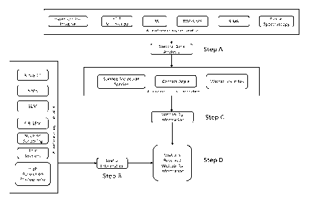
[0017] FIG. 1 shows a process flow chart of the determining of spatially
resolved wettability
of a sample according to an example of the present application.
DETAILED DESCRIPTION OF THE INVENTION
[0018] The present invention relates in part to a method which allows for
determining
wettability with spatial resolution of porous materials or other materials.
The method can allow
for production of spatially resolved maps of chemical components on the pore
surface and provide
other advantages and benefits. The method of this invention can help provide
absolute values of
- 4 -
CA 2948362 2017-09-07
wettability instead of relative values, and from there, 3D models can be
populated with the values
obtained. This invention can provide an absolute method of quantifying
wettability, and which is
a spatially resolved method. The method of the present invention can provide a
rapid alternative
to previous wettability determination methods which required a long time to
perform, and this
invention can be beneficial as a stand-alone service as well as improving
fluid flow simulations.
[0019] The materials, also referred to herein as the samples, to which the
present invention can
be applied are not necessarily limited. The materials can be porous materials,
such as porous
geological materials, e.g., rocks. The kinds of rock to which a method of the
present invention can
be applied are not necessarily limited. The rock sample can be, for example,
organic mud rock,
shale, carbonate, sandstone, limestone, dolostone, or other porous rocks, or
any combinations
thereof, or other kinds. Any source of a rock formation sample of manageable
physical size and
shape may be used with the present invention. Micro-cores, crushed or broken
core pieces, drill
cuttings, sidewall cores, outcrop quarrying, whole intact rocks, and the like,
may provide suitable
rock piece or fragment samples for analysis using methods according to the
invention.
[0020] The present invention relates in part to a method for determining
surface wettability of
a sample that includes steps of obtaining spectral data on a sample, obtaining
spatial information
on the sample, obtaining wettability information on the sample using the
spectral data, and
determining spatially resolved wettability information for the sample using
the wettability
information and spatial information. Spectral and spatial measurements may be
performed on the
exact same sample or the spectral measurement can be performed on one
sample(s) and the spatial
measurement performed on a second sample(s) where samples are of similar
composition and
structure.
- 5 -
CA 2948362 2017-09-07
[0021] Referring to FIG. 1, a process flow of a method of the present
invention is illustrated
which includes Steps A, B, C, and D.
[0022] In Step A, spectral data is obtained. The spectra are generated by,
but not limited to,
LIBS, TOF-SIMS, SIMS, FT1R, Raman spectroscopy, Hyperspectral Imaging, or any
equipment
capable of generating spectral data. More than one spectral data from various
methods can be used
for analysis.
[0023] In Step B, spatial imaging information/data is obtained. Spatial
information can be
generated by, but not limited to, X-Ray CT scanning, Scanning Electron
Microscopy (SEM),
Focused Ion Beam- Scanning Electron Microscopy (FIB-SEM), Nuclear Magnetic
Resonance
(NMR), Neutron Scattering, Thin Sections, High Resolution photography, or any
equipment
capable of generating spatial information. More than one spatial information
from various
equipment can be used for analysis.
[0024] The samples can undergo spectral measurement and spatial imaging in
the same setup,
or the samples can undergo spectral measurement and then are transferred to a
second setup for
spatial imaging, or the samples can undergo spatial imaging and are then
transferred to a second
equipment for spectral measurement, or the samples can undergo spectral
measurement and spatial
imaging and one or more intermediate measurements between the two types of
measurements.
Spectral and spatial measurements may be performed on the exact same sample or
the spectral
measurement can be performed on one sample(s) and the spatial measurement
performed on a
second sample(s) where samples are of similar composition and structure.
[0025] In Step C, wettability information is compiled from information on
contact angle,
surface molecular species, wettability index or indices, or any combinations.
Any single or
combination of Surface Molecular, Contact Angle, or Wettability can be used.
- 6 -
CA 2948362 2017-09-07
[0026] The contact angle can be estimated from the spectral measurements,
wherein the
contact angle is estimated from molecular species identified from the spectral
measurements, or
wherein univariate or multivariate analysis can be used to correlate the
spectral measurements to
contact angle.
[0027] As to surface molecular species, the molecular species on the
surface that can be
identified from spectral measurements are used to correlate the spectral
measurements to
wettability information derived from Amott-Harvey testing, USBM testing, Amott-
USBM testing,
NMR measurement, or other wettability description metrics, or wherein
univariate or multivariate
analysis can be used to correlate the spectral measurements to molecular
species.
[0028] As to wettability indices, univariate or multivariate analysis is
used to correlate the
spectral measurements to wettability derived from Amott-Harvey testing, USBM
testing, Amon-
USBM testing, or NMR measurement, or other wettability description metrics.
[0029] In Step D, appropriate spatial distribution of wettability indices
in the 2D or 3D models
can be determined through image segmentation, assigned manually, determined by
capillary
pressure simulation or measurements, or determined from previously spatially
resolved spectral
measurements. Appropriate spatial distribution of surface molecular species in
the 2D or 3D
models can be determined through image segmentation, assigned manually, by
capillary pressure
simulation or measurements, or determined from previously spatially resolved
spectral
measurements. Appropriate spatial distribution of contact angles in the 2D or
3D models can be
determined through image segmentation, assigned manually, by capillary
pressure simulation or
measurements, or determined from previously spatially resolved spectral
measurements.
[0030] FIG. 1 shows modes of spectral data acquisition which can have the
following features
and/or others. Time of Flight-Secondary Ion Mass Spectroscopy (TOF-SIMS) uses
ions to dislodge
- 7 -
CA 2948362 2017-09-07
molecules from sample surfaces. A variety of ions can be used, including, but
not limited to, Ga,
Au, Au2, Au3 and C60. Unlike dynamic SIMS, lower energies are used such that
molecular
structure of the ablated material remains intact. In dynamic SIM, higher
energy is used such that
the molecular structure is broken and only elements are measured.
[0031] For TOF-SIMS, the ablated components are then accelerated to a
constant kinetic
energy. If kinetic energy is held constant, then the time the species take to
travel will vary
depending on their mass. By measuring the time of flight, the time it takes
for the molecular
species to travel though the detector, their mass can be determined. From
component mass, the
molecular species can then be identified. The measurements are performed as a
raster, such that a
high resolution map of surface composition can be created. Results have then
been analysed using
multivariate analysis techniques, such as principle component analysis and
partial least squares
regression to relate surface composition.
[0032] TOP-SIMS has been used to determine contact angle for a variety of
different industries
such as the semi-conductor and medical industry. The mining industry has used
TOP-SIMS to
determine surface wettability of geology samples to estimate how well
different components will
separate during floatation separation.
[0033] Dynamic Secondary Mass Spectroscopy uses ions to dislodge molecules
from sample
surfaces. A variety of ions can be used, including, but not limited to, Ar,
Xe, 0, SFS and C60. A
mass spectrometer is then used to measure the mass of the produced species.
The energy of the
ions used is such that the molecular bonds of the surface materials are broken
and only the elements
are measured. The measurements are performed as a raster, such that a high
resolution map of
surface composition can be created. Results have then been analysed using
multivariate analysis
- 8 -
CA 2948362 2017-09-07
techniques, such as principle component analysis and partial least squares
regression to relate
surface composition.
[0034] Laser induced breakdown spectroscopy (LIBS) uses a laser to ablate a
tiny portion of
sample. The standard for LIBS uses a q-switched solid state laser that
produces a rapid pulse,
typically on the order of pico- to nanoseconds in duration. Optics are used to
focus the energy
onto a single spot on the sample. -The laser ablates a small amount of sample
at this spot, turning
it into a high temperature plasma. The excited atoms then return to a ground
state, giving off light
of characteristic frequencies. The spot size vaporized by the laser can range
in size from a few
microns up to hundreds of microns, allowing a large range of resolution and is
dependent on the
optics of the system. The signal quality improves with larger spot size, but
sacrifices resolution.
While a small amount of sample is consumed, the amount is so small that it is
considered to be
negligible and the technique is considered non-destructive. The wavelength of
light from the
plasma can be in the 200 to 980 nm region. The resulting spectra can be
analysed by multivariate
data to correlate the spectra to concentration of elements. LIBS has been used
previously as a
method for mineralogy identification, making it an alternative to X-ray
Diffraction (XRD) and X-
ray Fluorescence (XRF) methods for mineralogical analysis of samples. It has
an advantage over
XRF for mineralogical identification because it can measure all elements,
whereas XRF is unable
to detect light elements.
[0035] LIB S is able to perform depth profiling, firing the laser in the
same spot and observing
the different products that are produced with increased depth. LIBS is also
very rapid, only taking
per seconds per measurement making it amenable for high-throughput industrial
use. WS
measurements can be rastered to produce a two dimensional map of surface
composition.
- 9 -
CA 2948362 2017-09-07
[0036] Fourier transform infrared spectroscopy (FTIR) microscopy combines
FTIR
measurements with spatial resolution to produce a FTIR spectrum. FT1R works by
shining infrared
light upon a sample. Depending on the composition of the sample, some
wavelengths of light will
be absorbed while others will pass through the sample. The transmitted light
is then measured to
produce a spectra showing an absorption profile as a function of wavelength.
Organic matter and
inorganic minerals have characteristic absorption profiles which can be used
to identify sample
constituents. This may be done qualitatively or quantitatively by manual
assignment, use of
mineral libraries or multivariate analysis. The FTIR microscope advances
normal FTIR
measurements by combining the technique with an optical microscope such that
individual areas
of a sample can be selected and FTIR spectra taken, allowing composition at a
higher resolution
to be determined. Unlike standard FTIR measurements which are normally
performed on powders,
the FTIR microscopy can be performed on intact samples. Standard procedure for
geological FTIR
microscopy uses a sample that is polished to produce an even surface. FTIR
microscopy can be
performed via transmission FfIR, diffuse reflectance infrared fourier
transform spectroscopy
(DRIFTS), or attenuated total reflectance (ATR) FTIR.
[0037] Raman spectroscopy uses monochromatic light, usually from a laser,
to excite
rotational and vibrational modes in a sample. Raman spectroscopy measures the
Raman scattering,
the inelastic scattering that occurs when light interacts with matter. When
photons from the laser
interact with the molecular vibrations in the sample, they change the
excitation state of the
molecule. As the molecule returns to equilibrium, this results in the emission
of an inelastically
scattered photon that may be of higher or lower frequency than the excitation
depending on
whether the final vibration state of the molecule is higher or lower than the
original state. These
shifts give information on the vibrational and rotational modes of the sample,
which can be related
- 10 -
CA 2948362 2017-09-07
to its material composition. The signal to noise of Raman spectroscopy tends
to be weaker
compared to other methods such as FUR.
[0038]
Hyperspectral imaging creates a spectra for each pixel of an image. Light from
an
object passes through a dispersing element, such as a prism or a diffraction
grating, and then travels
to a detector. Optics are typically used in between the dispersing element and
the detector to
improve image quality and resolution. Hyperspectral imaging may range over a
wide range of light
wavelengths, including both visible and non-visible light. Multispectral is a
subset of
hyperspectral imaging that focuses on a few wavelengths of key interest.
Hyperspectral imaging
is defined by measuring narrow, well defined contiguous wavelengths.
Multispectral imaging
instead has broad resolution or the wavelengths to be measured are not
adjacent to each other.
Hyperspectral imaging has been used previously in a wide range of industries.
In particular,
hyperspectral imaging has been used in aerial mounted surveys to determine
mineralogy for oil,
gas, and mineral exploration,
[00391 FIG. I
also shows modes of spatial information acquisition, including X-ray CT, NMR,
SEM, FIB-SEM, neutron scattering, thin sections and high resolution
photography. These can be
adapted for use in the present invention from known equipment and manners of
use,
(0040] The
present invention includes the following aspects/embodiments/features in any
order and/or in any combination:
1. The
present invention relates to a method for determining surface wettability of a
sample,
comprising:
a) obtaining spectral data on at least one sample;
b) obtaining spatial information on at least one sample;
c) obtaining wettability information on the at least one sample using the
spectral data;
- 11 -
CA 2948362 2017-09-07
d) determining spatially resolved wettability information for the at least one
sample using the
wettability information and the spatial information, wherein the sample in a)
and the sample in b)
are the same or are different but have the same or similar composition and
structure.
2. The method of any preceding or following embodiment/feature/aspect,
wherein the
spectral data on the sample is generated by LIES, TOF-SIMS, SIMS, FTTR, FTIR
Microscopy,
Raman spectroscopy, Hyperspeeval Imaging, or any combinations thereof.
3. The method of any preceding or following embodiment/feature/aspect,
wherein the spatial
information on the sample is obtained by X-Ray CT scanning, Scanning Electron
Microscopy
(SEM), Focused Ion Beam- Scanning Electron Microscopy (FIB-SEM), Nuclear
Magnetic
Resonance (NMR), Neutron Scattering, Thin Sections, High Resolution
photography, or any
combinations thereof.
4. The method of any preceding or following embodiment/feature/aspect,
wherein the sample
undergoes spectral measurement and spatial imaging in the same setup, or the
sample undergoes
spectral measurement and then is transferred to a second setup for spatial
imaging, or the sample
undergoes spatial imaging and is then transferred to a second equipment for
spectral measurement,
or the sample undergoes spectral measurement and spatial imaging and one or
more intermediate
measurements between the two types of measurements. Spectral and spatial
measurements may
be performed on the exact same samples or two or more samples of similar
composition and
structure.
5. The method of any preceding or following embodiment/feature/aspect,
wherein the
wettability information is obtained with determined values for contact angle,
surface molecular
species, wettability index or indices, or any combinations thereof.
- 12 -
CA 2948362 2017-09-07
6. The method of any preceding or following embodiment/feature/aspect,
comprising
estimating the contact angle from spectral measurements on the sample, wherein
the contact angle
is estimated from molecular species identified from the spectral measurements
or wherein
univariate or multivariate analysis is used to correlate the spectral
measurements to contact angle.
7. The method of any preceding or following embodiment/feature/aspect,
comprising
determining the surface molecular species wherein molecular species on a
surface of the sample
identified from spectral measurements are used to correlate the spectral
measurements to
wettability derived from Amott-Harvey testing, USBM testing, Amott-USBM
testing, NMR
measurement, or other wettability description metrics, or wherein univariate
or multivariate
analysis is used to correlate the spectral measurements to molecular species.
8. The method of any preceding or following embodiment/feature/aspect,
comprising
determining wettability wherein univariate or multivariate analysis is used to
correlate the spectral
measurements to wettability derived from Amott-Harvey testing, USBM testing,
Amott-USBM
testing, NMR measurement, or other wettability description metrics.
9. The method of any preceding or following embodiment/feature/aspect,
wherein the
spatially resolved wettability information is at least one of spatial
distribution of wettability indices
in 2D or 3D models, spatial distribution of surface molecular species in 2D or
3D models, or spatial
distribution of contact angles in 2D or 3D models.
10. The method of any preceding or following embodiment/feature/aspect,
wherein the spatial
distribution of wettability indices in the 2D or 3D models is determined
through image
segmentation, assigned manually, determined by capillary pressure simulation
or measurements,
or determined from previously spatially resolved spectral measurements.
- 13 -
CA 2948362 2017-09-07
Ii. The method of any preceding or following embodiment/feature/aspect,
wherein the spatial
distribution of surface molecular species in the 21) or 31) models is
determined through image
segmentation, assigned manually, by capillary pressure simulation or
measurements, or
determined from previously spatially resolved spectral measurements.
12. The method of any preceding or following embodiment/feature/aspect,
wherein the spatial
distribution of contact angles in the 2D or 3D models is determined through
image segmentation,
assigned manually, by capillary pressure simulation or measurements, or
determined from
previously spatially resolved spectral measurements.
13. The method of any preceding or following embodiment/feature/aspect,
wherein the sample
is a porous sample.
14. The method of any preceding or following embodiment/feature/aspect,
wherein the sample
is a porous geological sample.
15. A system to perform the method of any preceding embodiment.
16. A system for determining surface wettability of a sample, comprising i)
a spectral data
acquisition device for obtaining spectral data on at least one sample; ii) a
spatial information
acquisition device for obtaining spatial information on at least one sample,
wherein the spectral
data acquisition device and the spatial information acquisition device are the
same device or
different devices, and wherein the sample used in i) and the sample used in
ii) are the same or are
different but have the same or similar composition arid structure; iii) one or
more computer systems
comprising at least one processor and/or computer programs stored on a non-
transitory computer-
readable medium operable to obtain wettability information on the sample used
in i) using the
spectral data, and to determine spatially resolved wettability information for
the sample or samples
- 14 -
CA 2948362 2017-09-07
used in i) and ii) using the wettability information and the spatial
information; and iv) at least one
device to display, print, and/or store as a non-transitory storage medium,
results of the computations.
[0041] The present invention can include any combination of these various
features or
embodiments above and/or below as set forth in sentences and/or paragraphs.
Any combination of
disclosed features herein is considered part of the present invention and no
limitation is intended
with respect to combinable features.
[0042] When an amount, concentration, or other value or parameter is given
as either a range,
preferred range, or a list of upper preferable values and lower preferable
values, this is to be
understood as specifically disclosing all ranges formed from any pair of any
upper range limit or
preferred value and any lower range limit or preferred value, regardless of
whether ranges are
separately disclosed. Where a range of numerical values is recited herein,
unless otherwise stated,
the range is intended to include the endpoints thereof, and all integers and
fractions within the
range. It is not intended that the scope of the invention be limited to the
specific values recited
when defining a range.
[0043] Other embodiments of the present invention will be apparent to those
skilled in the art
from consideration of the present specification and practice of the present
invention disclosed
herein. It is intended that the present specification and examples be
considered as exemplary only
with a true scope and spirit of the invention being indicated by the following
claims and equivalents
thereof.
- 15 -
CA 2948362 2017-09-07