Note : Les descriptions sont présentées dans la langue officielle dans laquelle elles ont été soumises.
CA 2968794 2017-05-31
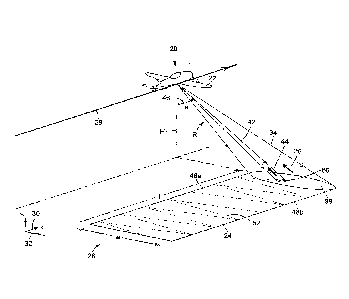
1
SYNTHETIC APERTURE IMAGING ASSISTED BY THREE-DIMENSIONAL
SCANNING IMAGING FOR HEIGHT RECONSTRUCTION
TECHNICAL FIELD
[0001] The technical field generally relates to synthetic aperture (SA)
imaging and, more
particularly, to height reconstruction techniques for implementation in SA
imaging
systems.
BACKGROUND
[0002] Synthetic aperture (SA) imaging can be used to increase resolution
beyond the
diffraction limit of a physical aperture of an imaging system. In SA imaging
systems, a
large "virtual" aperture is synthesized by illuminating a target region with
electromagnetic
signals transmitted from a moving platform and collecting phase-coherent
return echoes
produced by reflection of the electromagnetic signals from the target region.
The return
echoes are recorded and then coherently combined using signal processing
techniques
to reconstruct a high-resolution image of the target region. SA imaging was
initially
developed and has been successfully employed at radio frequencies, where it is
referred
to as "synthetic aperture radar" (SAR). Conventional SAR systems typically
operate in the
centimeter (cm) wavelength range and produce images with azimuth resolutions
of the
order of a decimeter (dm) to a meter (m). As resolution is generally inversely
proportional
to the imaging wavelength, there has been a growing interest to extend SAR to
shorter
wavelengths. In this context, an emerging technology referred to as "synthetic
aperture
ladar" (SAL) has been developed to extend SAR to visible and near-infrared
frequencies.
[0003] SA imaging systems provide two-dimensional (2D) SA images representing
projected ground surface reflectance. A 20 SA image can be represented as a
two-
dimensional complex-valued array of pixels, where each pixel has an amplitude
value and
a phase value. The two dimensions of the 2D SA image are the azimuth and the
slant-
range directions. For a target region having a non-flat topography, an
ambiguity exists
between ground range and height since various pairs of ground-range and height
values
may lead to a same slant-range value.
[0004] An approach to remove this ambiguity and provide three-dimensional (3D)
imaging
of a target region is known as "interferometric SA imaging", referred to as
IFSAR and
IFSAL depending on the operating wavelength. In this technique, two 2D SA
images are
2
acquired from different points of view relative to the target region. The 2D
SA images are
co-registered and interfered with each other, and an elevation map of the
target region is
extracted from their phase difference. A challenge in implementing
interferometric SA
imaging is that the height reconstruction process involves phase unwrapping,
which can
suffer from robustness limitations. This is especially true in the case of
IFSAL, since the
conditions on phase accuracy and platform stability required for
interferometry become
increasingly stringent as the wavelength decreases. Another challenge is that
since a 2D
SA image involves the projection of a 3D target region onto a 2D image plane,
slant-range
distortion effects such as foreshortening and layover can appear for target
regions with
irregular topography.
[0005] Laser-based scanning techniques such as scanning lidar provide another
approach to achieving 3D imaging of a target region. These techniques can be
implemented using various distance measurement methods, including time-of-
flight,
phase-shift, and frequency modulation methods. However, although laser-based
scanning
techniques can provide 3D images, their spatial resolution is limited by the
size of the
beam illuminating the target region.
SUMMARY
[0006] In accordance with an aspect, there is provided a method for synthetic
aperture
(SA) imaging of a target region from a platform in relative movement with
respect to the
target region along a travel path. The method includes:
generating a source optical signal and a local oscillator signal;
splitting the source optical signal, or a portion of the source optical
signal, into an
SA transmission beam and a scanning beam;
controlling an optical path length difference between the SA transmission beam
and the scanning beam;
illuminating, from the platform, the target region with the SA transmission
beam
and receiving, on the platform, an SA return signal produced by reflection of
the SA
transmission beam from the target region;
scanning, from the platform, and concurrently with illuminating the target
region
with the SA transmission beam, the target region with the scanning beam and
receiving, on the platform, a scanning return signal produced by reflection of
the
scanning beam from the target region;
Date Recue/Date Received 2020-10-26
3
mixing the SA return signal and the scanning return signal as a total return
signal
with the local oscillator signal using optical heterodyne detection to
generate return
signal data;
processing the return signal data based on the optical path length difference
to
obtain SA signal data associated with the SA return signal and scanning signal
data
associated with the scanning return signal;
generating an initial two-dimensional (2D) SA image of the target region from
the
SA signal data, the initial 2D SA image having an across-track dimension
measured
in slant-range coordinate;
generating a three-dimensional (3D) scanning image of the target region from
the
scanning signal data, and determining an elevation map of the target region
from the
3D scanning image; and
orthorectifying the initial 2D SA image based on the elevation map to obtain
an
orthorectified 2D SA image having an across-track dimension measured in ground-
range coordinate.
[0006a] In accordance with another aspect, there is provided a system for
synthetic
aperture (SA) imaging of a target region from a platform in relative movement
with respect
to the target region along a travel path. The system includes:
a source assembly mounted on the platform and configured to generate a source
optical signal and a local oscillator signal, the source assembly comprising a
splitting
device to split the source optical signal, or a portion of the source optical
signal, into
an SA transmission beam and a scanning beam having a controlled optical path
length
difference therebetween;
a transmitter-receiver assembly mounted on the platform and comprising:
an SA transmitter illuminating the target region with the SA transmission
beam;
a scanning transmitter scanning the target region with the scanning beam;
and
a receiver unit receiving, as a total return signal, an SA return signal and a
scanning return signal, respectively produced by reflection of the SA
transmission
beam and the scanning beam from the target region;
Date Recue/Date Received 2020-10-26
4
a detector assembly mounted on the platform and configured to mix the total
return
signal with the local oscillator signal using optical heterodyne detection to
generate
return signal data; and
a processing unit coupled to the detector assembly and configured to:
process the return signal data based on the optical path length difference to
obtain SA signal data associated with the SA return signal and scanning signal
data associated with the scanning return signal;
generate an initial two-dimensional (2D) SA image of the target region from
the SA signal data, the initial 2D SA image having an across-track dimension
measured in slant-range coordinate;
generate a three-dimensional (3D) scanning image of the target region from
the scanning signal data;
determine an elevation map of the target region from the 3D scanning image;
and
orthorectify the initial 2D SA image based on the elevation map to obtain an
orthorectified 20 SA image having an across-track dimension measured in
ground-range coordinate.
[0006b] In accordance with another aspect, there is provided a method for
synthetic
aperture (SA) imaging of a target region from a platform in relative movement
with respect
to the target region along a travel path. The methods includes:
generating at least one SA transmission beam, a scanning beam, and a local
oscillator signal;
controlling an optical path length difference between the at least one SA
transmission beam and the scanning beam;
illuminating, from the platform, the target region with the at least one SA
transmission beam, and receiving, on the platform, at least one SA return
signal
produced by reflection of the at least one SA transmission beam from the
target region;
scanning, from the platform, and concurrently with illuminating the target
region
with the at least one SA transmission beam, the target region with the
scanning beam
and receiving, on the platform, a scanning return signal produced by
reflection of the
scanning beam from the target region;
Date Recue/Date Received 2020-10-26
5
mixing the at least one SA return signal and the scanning return signal as a
total
return signal with the local oscillator signal using optical heterodyne
detection to
generate return signal data;
processing the return signal data based on the optical path length difference
to
obtain SA signal data associated with the at least one SA transmission beam
and
scanning signal data associated with the scanning return signal;
generating two or more two-dimensional (2D) SA images of the target region
from
the SA signal data, and combining the two or more 2D SA images to obtain a
phase-
wrapped three-dimensional (3D) SA image of the target region;
generating a 3D scanning image of the target region from the scanning signal
data,
and determining an elevation map of the target region from the 3D scanning
image;
and
unwrapping the phase-wrapped 3D SA image based on the elevation map to obtain
a phase-unwrapped 3D SA image.
[0006c] In accordance with another aspect, there is provided a system for
synthetic
aperture (SA) imaging of a target region from a platform in relative movement
with respect
to the target region along a travel path. The system includes:
a source assembly mounted on the platform and configured to generate a source
optical signal and a local oscillator signal, the source assembly comprising a
splitting
device configured to split the source optical signal, or a portion of the
source optical
signal, into a first SA transmission beam, a second SA transmission beam, and
a
scanning beam having controlled optical path length differences therebetween;
a transmitter-receiver assembly mounted on the platform and comprising:
a first SA transmitter illuminating the target region with the first SA
transmission beam, and a second SA transmitter illuminating the target region
with the second SA transmission beam, the second SA transmitter being
separated from the first SA transmitter by a baseline distance;
a scanning transmitter scanning the target region with the scanning beam;
and
a receiver unit receiving, as a total return signal, a first SA return signal,
a
second SA return signal and a scanning return signal, respectively produced by
reflection of the first SA transmission beam, the second SA transmission beam
and the scanning beam from the target region;
Date Recue/Date Received 2020-10-26
5a
a detector assembly mounted on the platform and configured to mix the total
return
signal with the local oscillator signal using optical heterodyne detection to
generate
return signal data; and
a processing unit coupled to the detector assembly and configured to:
process the return signal data based on the optical path length differences to
obtain first SA signal data and second SA signal data respectively associated
with the first and second SA transmission beams, and scanning signal data
associated with the scanning return signal;
generate first and second two-dimensional (2D) SA images of the target
region respectively from the first SA signal data and the second SA signal
data,
and combine the first and second 2D SA images to obtain a phase-wrapped
three-dimensional (3D) SA image of the target region;
generate a 3D scanning image of the target region from the scanning signal
data, and determine an elevation map of the target region from the 3D scanning
image; and
unwrap the phase-wrapped 3D SA image based on the elevation map to
obtain a phase-unwrapped 3D SA image.
[0006d] In accordance with another aspect, there is provided a method for
synthetic
aperture (SA) imaging of a target region from a platform in relative movement
with respect
to the target region along a travel path. The method includes:
illuminating the target region with an SA transmission beam transmitted from
the
platform, and receiving, on the platform, an SA return signal produced by
reflection of
the SA transmission beam from the target region;
generating an initial two-dimensional (2D) SA image of the target region from
the
SA return signal, the initial 2D SA image having an across-track dimension
measured
in slant-range coordinate;
scanning, concurrently with illuminating the target region with the SA
transmission
beam, the target region with a scanning beam transmitted from the platform,
and
receiving, on the platform, a scanning return signal produced by reflection of
the
scanning beam from the target region;
generating a three-dimensional (3D) scanning image of the target region from
the
scanning return signal, and determining an elevation map of the target region
from the
3D scanning image; and
Date Recue/Date Received 2020-10-26
5b
orthorectifying the initial 2D SA image based on the elevation map to obtain
an
orthorectified 2D SA image having an across-track dimension measured in ground-
range coordinate.
[0007] In accordance with another aspect, there is provided a system for
synthetic
aperture (SA) imaging of a target region from a platform in relative movement
with respect
to the target region along a travel path. The system includes:
a source assembly mounted on the platform and configured to generate an SA
transmission beam and a scanning beam;
a transmitter-receiver assembly mounted on the platform and including:
an SA transmitter illuminating the target region with the SA transmission
beam;
a scanning transmitter scanning the target region with a scanning beam; and
a receiver unit receiving an SA return signal and a scanning return signal,
respectively produced by reflection of the SA transmission beam and the
scanning beam from the target region;
a detector assembly mounted on the platform and configured to detect the SA
return signal and the scanning return signal received by the receiver unit;
and
a processing unit coupled to the detector assembly and configured to:
generate an initial two-dimensional (2D) SA image of the target region from
the SA return signal, the initial 2D SA image having an across-track dimension
measured in slant-range coordinate;
generate a three-dimensional (3D) scanning image of the target region from
the scanning return signal;
determine an elevation map of the target region from the 3D scanning image;
and
orthorectify the initial 2D SA image based on the elevation map to obtain an
orthorectified 20 SA image having an across-track dimension measured in
ground-range coordinate.
[0008] In accordance with another aspect, there is provided a method for
synthetic
aperture (SA) imaging of a target region from a platform in relative movement
with respect
to the target region along a travel path. The method includes:
Date Recue/Date Received 2020-10-26
5c
acquiring two or more two-dimensional (2D) SA images of the target region, and
combining the two or more 2D SA images to obtain a phase-wrapped three-
dimensional (3D) SA image of the target region;
scanning, concurrently with acquiring the two or more 2D SA images, the target
region with a scanning beam transmitted from the platform, and receiving, on
the
platform, a scanning return signal produced by reflection of the scanning beam
from
the target region;
generating a 3D scanning image of the target region from the scanning return
signal, and determining an elevation map of the target region from the 3D
scanning
image; and
unwrapping the phase-wrapped 3D SA image based on the elevation map to obtain
a phase-unwrapped 3D SA image.
[0009] In accordance with another aspect, there is provided a system for
synthetic
aperture (SA) imaging of a target region from a platform in relative movement
with respect
to the target region along a travel path. The system includes:
a source assembly mounted on the platform and configured to generate two SA
transmission beams and a scanning beam;
a transmitter-receiver assembly mounted on the platform and including:
a first SA transmitter illuminating the target region with a first SA
transmission
beam, and a second SA transmitter illuminating the target region with a second
SA transmission beam, the second SA transmitter being separated from the first
SA transmitter by a baseline distance;
a scanning transmitter scanning the target region with a scanning beam; and
a receiver unit receiving a first SA return signal, a second SA return signal
and a scanning return signal, respectively produced by reflection of the first
SA
transmission beam, the second SA transmission beam and the scanning beam
from the target region;
a detector assembly mounted on the platform and configured to detect the first
SA
return signal, the second SA return signal and the scanning return signal
received by
the receiver unit; and
a processing unit coupled to the detector assembly and configured to:
generate first and second two-dimensional (2D) SA images of the target
region respectively from the first and second SA return signals, and combine
the
Date Recue/Date Received 2020-10-26
5d
first and second 2D SA images to obtain a phase-wrapped three-dimensional
(3D) SA image of the target region;
generate a 3D scanning image of the target region from the scanning return
signal, and determine an elevation map of the target region from the 3D
scanning
image; and
unwrap the phase-wrapped 3D SA image based on the elevation map to
obtain a phase-unwrapped 3D SA image.
[0010] Other features and advantages of the present description will become
more
apparent upon reading of the following non-restrictive description of specific
embodiments
thereof, given by way of example only with reference to the appended drawings.
BRIEF DESCRIPTION OF THE DRAWINGS
[0011] Fig. 1 is a flow diagram of a method for SA imaging, in accordance with
a possible
embodiment.
[0012] Fig. 2 is a schematic perspective view of an SA imaging system mounted
on a
platform in relative movement with respect to a target region, in accordance
with a possible
embodiment.
[0013] Fig. 3 is a schematic front view of an SA imaging system, illustrating
an ambiguity
that may exist in determining the combination of ground range and elevation
values that
corresponds to a given measured slant range value.
[0014] Fig. 4 is a schematic block diagram of an SA imaging system with beam
scanning
imaging capabilities, in accordance with another possible embodiment.
[0015] Fig. 5 is a flow diagram of another method for SA imaging, in
accordance with a
possible embodiment.
[0016] Fig. 6 is a schematic perspective view of an SA imaging system mounted
on a
platform in relative movement with respect to a target region and using single-
pass
interferometric SA imaging, in accordance with a possible embodiment.
[0017] Fig. 7 is a schematic perspective view of an SA imaging system mounted
on a
platform in relative movement with respect to a target region and using
multiple-pass
interferometric SA imaging, in accordance with a possible embodiment.
Date Recue/Date Received 2020-10-26
CA 2968794 2017-05-31
6
[0018] Fig. 8 is a schematic block diagram of another SA imaging system with
beam
scanning imaging capabilities, in accordance with a possible embodiment.
DETAILED DESCRIPTION
[0019] In the following description, similar features in the drawings have
been given similar
reference numerals and, to not unduly encumber the figures, some elements may
not be
indicated on some figures if they were already identified in a preceding
figure. It should
also be understood herein that the elements of the drawings are not
necessarily depicted
to scale, since emphasis is placed upon clearly illustrating the elements and
structures of
the present embodiments.
[0020] The present description generally relates to methods for synthetic
aperture (SA)
imaging and to imaging systems capable of implementing the methods. Broadly
stated,
the present techniques use three-dimensional (3D) beam scanning imaging, for
example
3D scanning lidar, to provide or enhance 30 imaging capabilities in SA
imaging. In some
implementations, the method can include concurrently acquiring an SA image and
a 3D
scanning image of a target region, determining an elevation map of the target
region from
the 3D scanning image, and processing the SA image based on the elevation map
thus
determined. For example, in some implementations, the SA image is a two-
dimensional
(2D) SA image and the elevation map is used to orthorectify the 2D SA image.
In other
implementations, the SA image is a 3D SA image and the elevation map is used
to perform
phase unwrapping on the 3D SA image. The present techniques can be implemented
in
an imaging system mounted on a platform in relative movement with respect to
the target
region. In some implementations, the imaging system can include a single
optical source
that generates all the optical beams used to illuminate or scan the target
region.
[0021] In the present description, a 2D SA image of a target region refers to
a 2D pixel
array having an along track dimension and an across-track dimension. Each
pixel of the
array is associated with a respective area of the target region and provides a
complex
number (amplitude and phase information) representing the surface reflectance
of the
associated area. Meanwhile, a 3D image of a target region, for example a 3D
scanning
image or a 3D SA image, also refers to a 2D pixel array having an along track
dimension
and an across-track dimension and where each pixel of the array is associated
with a
respective area of the target region. However, rather than providing
reflectance-based
CA 2968794 2017-05-31
7
information, each pixel of the 3D image has a value representative of the
local height or
elevation of the associated area of the target region.
[0022] The present techniques can be used in SA leder (SAL) applications
employing
wavelengths in the visible or near-infrared portions of the electromagnetic
spectrum.
Those skilled in the art will recognize, however, that the present techniques
can also be
applied to other types of SA imaging modalities, including, but not limited
to, SA radar
(SAR) imaging, SA terahertz imaging and SA infrared imaging. In the present
description,
the terms "light" and "optical" are used to refer to radiation in any
appropriate region of the
electromagnetic spectrum, for example, the radio, microwave, terahertz,
infrared, visible
and ultraviolet wavelength ranges. For example, in SAL applications, the terms
"light" and
"optical" can encompass electromagnetic radiation having a wavelength ranging
from a
few hundreds of nanometers (nm) to a few micrometers (pm).
[0023] Referring to Fig. 1, there is provided a flow diagram of an embodiment
of a
method 200 for SA imaging of a target region from a platform in relative
movement with
respect to the target region along a travel path. The method 200 generally
involves the
acquisition of two images of the target region: an initial 2D SA image and a
3D scanning
image. As will be described, the 3D scanning image is used to determine an
elevation
map of the target region, which in turn is used to orthorectify the initial 2D
SA image.
[0024] The method 200 of Fig. 1 can be implemented in an imaging system 20
mounted
on a platform 22 that moves with respect to a target region 24 of a scene 26,
such as
illustrated in Fig. 2. In this embodiment, the platform 22 moves along a
travel path 28 at
an altitude H above the target region 24. The target region 24 corresponds to
an area or
feature of interest in the scene 26, for example a ground surface of the
Earth. The target
region 24 has a length / along an azimuth, or along-track, direction 30
parallel to the travel
path 28, and a width w along a ground-range direction 32 perpendicular to the
azimuth
direction 30. For example, in some embodiments, the width w of the target
region 24 can
range between 0.5 m and 5 m, while the length /of the target region 24 can
range between
10 m and 1000 m. In the illustrated embodiment, the platform 22 is an airplane
that travels
over a stationary target region 24. However, various other types of manned or
unmanned
.. airborne, spaceborne and terrestrial vehicles could be used in other
embodiments.
Moreover, in other embodiments, it can be the target region that moves with
respect to the
CA 2968794 2017-05-31
8
platform, while in yet other embodiments, both the platform and the target
region can
move.
[0025] Referring still to both Figs. 1 and 2, the method 200 includes a step
202 of
illuminating the target region 24 with an SA transmission beam 34 transmitted
from the
platform 22, and a step 204 of receiving, on the platform, an SA return signal
36 produced
by reflection of the SA transmission beam 34 from the target region 24. The
method 200
also includes a step 206 of generating an initial 2D SA image SsA,2D(R, x) of
the target
region 24 from the SA return signal. The initial 2D SA image SsA,21J(R, x) has
an across-
track dimension measured in slant-range coordinate R and an along-track
measured in
azimuth coordinate x. In Fig. 2, the SA transmission beam 34 illuminates the
target
region 24 in a zero-squint side-looking stripmap mode. In this mode, the
platform 22
moves along the azimuth direction 30 and the SA transmission beam 34 points
perpendicularly to the travel path 28 along a slant-range direction. Other SA
operation
modes can be used in other variants, for example a scanning mode, a spotlight
mode, and
a forward- or backward-squinted side-looking stripmap mode.
[0026] The area of the scene 26 illuminated by the SA transmission beam 34 at
a given
time, corresponding to a given position of the platform 22 along its travel
path 28, is
referred to as the footprint 38 of the SA transmission beam 34. As the
platform 22 moves
along the travel path 28, the footprint 38 of the SA transmission beam 34
moves
accordingly, thereby illuminating a swath that defines the target region 24.
In some
implementations, the SA transmission beam footprint 38 can have a ground-range
extent
that ranges between 0.5 m and 5 m, and an azimuth-extent that ranges between
0.1 m
and 2 m.
[0027] The step 206 of generating the initial 2D SA image SsA,2D(R, x) of the
target
.. region 24 from the SA return signal 36 can involve recording the SA return
signal 36 as a
series of phase-coherent return echoes, and then coherently combining the
return echoes
using appropriate signal extraction and processing techniques to generate the
initial 2D
SA image SsA,2D(R, x). The general principles underlying the generation of SA
images are
known in the art, and need not be covered in detail herein.
[0028] The fact that the across-track dimension of the initial 2D SA image
SsA,2D(R, x) is
along the slant-range direction R, rather than along the ground-range
direction r, can
CA 2968794 2017-05-31
9
cause image distortions. For example, for a non-flat target region, an
ambiguity exists
between ground range and elevation, since various pairs of ground-range and
elevation
values (r, h) can be compatible with a given slant-range value R. This is
illustrated in Fig. 3,
which shows three features 40a to 40c of a target region 24 having different
ground ranges
ra, rb, rc, and heights ha, ha and hc, but the same slant-range distance R to
an airborne
platform 22. Other examples of distortion effects caused by the side-looking
SA viewing
geometry include foreshortening, layover and shadowing. A slant-range-based SA
image
can be transformed into a ground-range-based SA image by correcting each pixel
of the
image for the local topography of the target region. The present techniques
provide a
manner of obtaining information about the local topography of a target region
and using
this information to correct slant-range-based 20 SA images.
[0029] Returning to Figs. 1 and 2, the method 200 further includes a step 208
of scanning,
concurrently with the step 202 of illuminating, the target region 24 with a
scanning
beam 42 transmitted from the platform 22, and a step 210 of receiving, on the
platform 22,
a scanning return signal 44 produced by reflection of the scanning beam 42
from the target
region 24. The method 200 also includes a step 212 of generating a 3D scanning
image
of the target region 24 from the scanning return signal 44. In the present
description, the
term "concurrently" refers to two processes that occur during coincident or
overlapping
time periods. It should be noted that the term "concurrently" does not
necessarily imply
complete synchronicity and encompasses various scenarios including: time-
coincident
occurrence of two processes; occurrence of a first process that both begins
and ends
during the duration of a second process; and occurrence of a first process
that begins
during the duration of a second process, but ends after the completion of the
second
process.
[0030] The scanning of the target region 24 can involve sweeping the scanning
beam 42
across the target region 24 along a scanning path 46. The scanning beam 42 can
be made
of any suitable type of electromagnetic waves. In some implementations, the
scanning
beam 42 can be a collimated laser beam in the near-infrared or short-wave
infrared. The
scanning of the target region 24 can be implemented with a scanning lidar or
another
scanning-based optical ranging technology. In the present description, the
term "scan" and
derivatives thereof refer to the fact that the scanning beam 42 is guided in a
point-by-point
manner over the target region 24 not only because of the relative movement
between the
target region 24 and the platform 22, as in SA imaging, but also because of
the time-
CA 2968794 2017-05-31
variation of the scanning angle e of the scanning beam 42 with respect to the
vertical to
the platform 22 itself. The beam scanning can be achieved by means of a mirror-
based or
another scanning technology. In the embodiment of Fig. 2, the imaging system
20 is
configured to sweep the scanning beam 42 back and forth between a near edge
48a and
5 a far edge 48b of the target region 24, which involves continuously
changing the scanning
angle 61, or pointing direction, of the scanning beam 42 over a certain range
of scanning
angles in a plane perpendicular to the azimuth direction 30 in the reference
frame of the
moving platform 22. Of course, various types of scanning patterns can be used
in other
embodiments.
10 .. [0031] The area of the scene 26 that is illuminated by the scanning beam
42 at a given
time, corresponding to a given position of the platform 22 along its travel
path 28 and a
given scanning angle 0 of the scanning beam 42 along its scanning path 46,
defines a
footprint 50 of the scanning beam 42. The footprint 50 of the scanning beam 42
is typically
much smaller than the footprint 38 of the SA transmission beam 34, since the
smaller the
footprint 50 of the scanning beam 42, the better the resolution of the 3D
scanning image.
For example, the footprint 50 of the scanning beam 42 can have a ground-range
extent
that ranges between 1 millimeter (mm) and 10 cm, and an azimuth-extent that
ranges
between 1 mm and 10 cm. Due to the combination of the sweeping of the scanning
beam 42 along the ground-range direction 32 and the relative motion of the
platform 22
along the azimuth direction 30, the footprint 50 of the scanning beam 42 forms
a 2D
scanning trace 52 over the target region 24. For example, the scanning trace
52 in the
embodiment of Fig. 2 has a zigzag shape and a ground-range extent that
substantially
matches the width w of the target region 24. It is to be noted that while in
the illustrated
embodiment the footprint 50 of the scanning beam 42 remains inside the
footprint 38 of
the SA transmission beam 34 throughout the scanning process, this need not be
the case
in other embodiments.
[0032] The step 212 of generating the 3D scanning image of the target region
24 from the
scanning return signal 44 can involve recording the received scanning return
signal 44 as
a spatially distributed pattern of target returns. Each target return forming
the scanning
return signal 44 constitutes a range measurement at a specific azimuth
position x of the
platform 22 along its travel path 28 and a specific scanning angle e of the
scanning
beam 42 along its scanning path 46. By combining the range measurements with
time-
dependent measurements of the absolute position and orientation of the
platform 22, a 30
CA 2968794 2017-05-31
11
scanning image Ssõn(x, 0) of the target region 24 can be generated. The
absolute position
and orientation of the platform 22 can be measured using a global positioning
system
(GPS) and an inertial measurement unit (IMU). The 3D scanning image Ss..,(x,
0) can be
represented as a 2D pixel array having an azimuth dimension x and a scanning-
angle
.. dimension 0, in which each pixel has a value representing the slant range R
measured at
the azimuth and scanning-angle coordinates of the pixel. It is to be noted
that while the
3D scanning image has a spatial resolution typically lower than that of the
initial 2D SA
image, it has the benefit of providing 3D rather than 2D imaging capabilities.
The general
principles underlying the generation of 3D scanning images using a scanning
beam swept
across a target region are known in the art, and need not be covered in detail
herein.
[0033] Referring still to Figs. 1 and 2, the method 200 further includes a
step 214 of
determining an elevation map h(R, x) of the target region 24 from the 3D
scanning image
Smin(x, 0). The elevation map h(R, x) provides a 3D representation of the
surface of the
target region 24. Determining the elevation map h(R, x) of the target region
24 from
.. knowledge of the 3D scanning image Sscs,,(x, 0) and the altitude Hof the
platform 22 along
the travel path 28 is straightforward using simple trigonometry, as is
projecting the
elevation map h(R, x) into ground-range coordinate to yield h(r, x). More
detail will be
provided about possible system implementations before describing how the
elevation map
h(r, x) can be used to correct the initial 2D SA image SsA,2D(R, x).
[0034] Referring to Fig. 4, there is provided a schematic block diagram of an
embodiment
of an imaging system 20 configured for SAL applications, for example in the
near-infrared,
and enabling 3D scanning imaging, for example scanning lidar technology. The
imaging
system 20 can correspond to that illustrated in Fig. 2, and can be used to
implement the
method 200 of Fig. 1.
[0035] The imaging system 20 of Fig. 4 includes a source assembly 54 mounted
on the
platform 22. The source assembly 54 includes an optical source 56 that
generates a
source optical signal 58, and an optical splitting device 60 that splits that
source optical
signal 58, or a portion thereof, into the SA transmission beam 34 and the
scanning
beam 42. It is to be noted that in other implementations, the SA transmission
beam 34 and
the scanning beam 42 can be generated by different optical sources, which may
or may
not operate in the same portion of the electromagnetic spectrum. Depending on
the
application, the SA transmission beam 34 and the scanning beam 42 may or may
not be
CA 2968794 2017-05-31
12
phase-coherently synchronized with each other. In Fig. 2, the source assembly
54 also
includes a signal-local oscillator (LO) splitter 62 upstream of the optical
splitting device 60
to extract a portion of the source optical signal 58 to be used as an LO
signal 64 in the
detection process, as described below. In other embodiments, the source
optical signal 58
and the LO signal 64 can be generated by different optical sources. The
embodiment of
Fig. 2 transmits the SA transmission beam 34 and the scanning beam 42 using
optical
fibers, but other embodiments can use bulk optical components.
[0036] The optical source 56 can be embodied by any appropriate device or
combination
of devices apt to generate a source optical signal from which an SA
transmission beam
and a scanning beam, suitable respectively for SA imaging and 3D scanning
imaging, can
be generated. By way of example, in SAL applications assisted by scanning
lidar, both the
SA transmission beam 34 and the scanning beam 42 can have a center frequency
ranging
from about 30 terahertz (THz) to about 300 THz, for example 193 THz,
corresponding to
a wavelength of 1.55 pm. Non-limiting examples for the optical source 56
include a gas
laser, a solid-state laser, a diode laser, a dye laser, and a non-laser
source. For SAL
applications, the optical source 56 is generally a laser source. For example,
in some
implementations, the optical source 56 can be embodied by a pulsed fiber laser
provided
with a directly modulated laser diode configured to perform a linear or
nonlinear frequency
modulation, or chirp, of the source optical signal 58. Alternatively, the
source optical
signal 58 can be a continuous-wave optical source whose output is coupled to
an external
waveform modulator or phase shifter. It is to be noted that using chirped
signals in
combination with a coherent detection scheme (e.g., optical heterodyne
detection) can
improve the range resolution in both SA and 3D scanning imaging. In Fig. 4,
the SA
transmission beam 34 and the scanning beam 42 have the same linear chirp
waveform
inherited from the source optical signal 58. In some implementations, the SA
transmission
beam 34 and/or the scanning beam 42 can also or alternatively be individually
modulated
or otherwise conditioned downstream of the optical splitting device 60.
[0037] In the present description, the term "optical splitting device" is
intended to refer to
a device capable of dividing an input optical signal into two or more signal
parts. The signal
parts may or may not be all identical. In some implementations, the optical
splitting device
is configured to perform either a power splitting or a spectral splitting of
the input optical
signal. In other implementations, the optical splitting device is configured
to perform a
CA 2968794 2017-05-31
13
time-based splitting of the input optical signal, in which the input optical
signal is divided
temporally into the two or more signal parts.
[0038] For example, in the embodiment of Fig. 4, the optical splitting device
60 is
configured to perform a time-based splitting of the source optical signal 58
to generate the
SA transmission beam 34 and the scanning beam 42. The source optical signal 58
is
emitted as a series of linearly chirped laser pulses 66 at a pulse repetition
rate of N pulses
per second, for example between a few pulses and a few thousands of pulses per
second.
The pulse duration can range from a few nanoseconds to a few microseconds.
From each
sequence of N pulses 66, NSA pulses 68 are selected to form the SA
transmission
beam 34 and Ns = N - NSA pulses 70 are selected to form the scanning beam 42.
For ease
of illustration, the ratio Ns/NSA is equal to three in Fig. 4. In practice, Ns
is often larger than
NSA, that is, Ns/NSA can range from 1 to 20.
[0039] Referring still to Fig. 4, the imaging system 20 includes a transmitter-
receiver
assembly 72 mounted on the platform 22. The transmitter-receiver assembly 72
can
include an SA transmitter 74 for illuminating the target region 24 with the SA
transmission
beam 34 and a scanning transmitter 76 for scanning the target region 24 with
the scanning
beam 42. The transmitters 74, 76 can include appropriate optics to shape or
condition the
SA transmission beam 34 and the scanning beam 42. More specifically, the
scanning
transmitter 76 can include collimating optics 78 to collimate the scanning
beam 42, and a
scanning device 80, for example a lidar scanning device, to scan the
collimated scanning
beam 42 back and forth widthwise across the target region 24. By collimating
the scanning
beam 42, its footprint on the target region 24 can be made smaller. In the
illustrated
embodiment, the scanning device 80 includes a fast steering mirror, but other
mirror-
based or non-mirror-based scanning technologies can be used in other
embodiments. The
orientation of the scanning device 80 is continuously swept in time over a
range of possible
orientations along the scanning path 46, thus effectively changing the
pointing direction of
the scanning beam 42.
[0040] Referring still to Fig. 4, the transmitter-receiver assembly 72 can
also include a
receiver unit 82 configured to receive the SA return signal 36 and the
scanning return
signal 44. The receiver unit 82 can include appropriate receiving optics, for
example lens,
mirrors or optical filters, to collect the SA return signal 36 and the
scanning return
signal 44. Depending on the application, the receiver unit 82 can be embodied
by a single
CA 2968794 2017-05-31
14
receiver or a plurality of receivers. It is to be noted that the SA return
signal 36 and the
scanning return signal 44 are generally not discriminated by the receiver unit
82 as
separate signals, but rather as a total return signal 84. The respective
contributions of the
SA return signal 36 and the scanning return signal 44 to the total return
signal 84 can be
identified later in the detection process, as described below. In the
embodiment of Fig. 4,
the SA transmitter 74, the scanning transmitter 76 and the receiver unit 82
are depicted
as three separate devices, but various other configurations can be used in
other
embodiments.
[0041] Referring still to Fig. 4, the imaging system 20 also includes a
detector
assembly 86 mounted on the platform 22. The detector assembly 86 is configured
to
detect the SA return signal 36 and the scanning return signal 44 received by
the receiver
unit 82. In the illustrated embodiment, the detection process employs optical
heterodyne
detection with chirped signals. The detector assembly 86 can mix the total
return signal 84
with the LO signal 64 on one or more photodetectors, for example PIN or
avalanche
photodiode detectors. Each photodetector can generate an electrical signal
containing two
distinct beat frequency bands, one corresponding to the SA return signal 36
and the other
corresponding to the scanning return signal 44. For chirped signals, the beat
frequencies
depend on the optical path length difference, or relative time delay, between
the LO and
return signals. Controlling the optical path length difference between the SA
transmission
beam 34 and the scanning beam 42 can therefore facilitate the discrimination
of the SA
return signal 36 from the scanning return signal 44. The measured electrical
signals can
be digitally sampled and stored as return signal data. The return signal data
can be
processed to extract or retrieve SA signal data associated with the SA return
signal 36
and scanning signal data associated with the scanning return signal 44. The SA
signal
data and scanning signal data can in turn be processed to reconstruct the
initial 2D SA
image SsA,2D(R, x) and the 3D scanning image Sscan(x, 0) of the target region
24.
[0042] The imaging system 20 of Fig. 4 also includes a processing unit 88
coupled to the
detector assembly 86 and configured, among other things, to: generate the
initial 2D SA
image SsA,2D(R, x) and the 3D scanning image Sscan(x, 0) from the SA signal
data and the
scanning signal data, respectively; determine the elevation map h(r, x) of the
target
region 24 from the 3D scanning image Sscan(x, 0); and, as described below,
orthorectify
the initial 2D SA image SsA,20(R, x) using the elevation map h(r, x). The
processing unit 88
can be provided as a single unit or as a plurality of interconnected sub-
units, and be
CA 2968794 2017-05-31
implemented in hardware, software, firmware or any combination thereof. For
example,
the processing unit 88 can be embodied by a microprocessor, a central
processing unit
(CPU), a microcontroller, or by any other processing resource or any
combination of such
processing resources configured to operate collectively as a processing unit.
The SA
5 signal data and the scanning signal data can be transmitted from the
detector assembly 86
to the processing unit 88 via wired and/or wireless transmission links. In
Fig. 4, the
processing unit 88 is physically located on the moving platform 22. However,
it can also
be envisioned that the processing unit 88 be provided at another location, for
example at
a ground-based processing station.
10 [0043] Returning to the flow diagram of Fig. 1, the method 200 further
includes a step 216
of orthorectifying the initial 2D SA image SsA,2D(R, x) based on the elevation
map h(r, x) of
the target region to obtain an orthorectified 2D SA image SsA,2D(r, x) having
an across-
track dimension measured in ground-range coordinate r rather than in slant-
range
coordinate R. Orthorectification aims to provide an image of the target region
as if viewed
15 directly from above. The process can involve performing a mapping into
ground-range
coordinate r of each pixel of the initial 2D SA image SsA,2D(R, x) mapped in
slant-range
coordinate R, thus effectively correcting for the local topography of the
target region. The
process of orthorectification can therefore allow slant-range distortion
effects, such as the
ambiguity between ground range and elevation illustrated in Fig. 3, to be
corrected.
[0044] In some implementations, the orthorectifying step 216 can involve co-
registering
the initial 2D SA image SsA,2D(R, x) and the elevation map h(r, x) to provide
a one-to-one
correspondence between the pixels of the 2D SA image SsA,2D(R, x) and the
pixels of the
elevation map h(r, x). In some implementations, image co-registration can
involve
interpolating either the initial 2D SA image SsA,2D(R, x) or the elevation map
h(r, x), typically
the latter. The orthorectifying step 216 can also include performing the
ground-range
projection r = Rcos(tp) for each pixel of SsA,2D(R, x) to obtain a distorted
ground-projected
2D SA image SSA,2D,GP(r, x), where tp is the nominal depression angle of the
SA
transmission beam. The orthorectifying step 216 can further include moving the
ground-
range coordinate of each pixel of SsA20,Gp(r, x) by h(r, x)tan(q.1) to obtain
the orthorectified
2D SA image SSA,2D(r, X), that is, SSA,2D(r, = SSA,2D,GP(r h(r, x)tan(tp),
x). It is to be noted
that moving each pixel of SSA,2D, GP(r, x) in this manner can involve
fractional shifts of the
ground-range coordinate, and thus image interpolation.
CA 2968794 2017-05-31
16
[0045] It is to be noted that acquiring the initial 2D SA image SsA,2D(R, x)
and the 3D
scanning image Sscan(x, 0) concurrently and from the same or nearly the same
perspective
on the platform can ease both image co-registration and correction of
uncompensated
optical-path-length fluctuations caused by unintended platform motion
deviations.
[0046] Referring now to Fig. 5, there is provided a flow diagram of an
embodiment of
another SA imaging method 300. The method 300 of Fig. 5 generally involves the
generation of two 3D images of a target region: a phase-wrapped 3D SA image
and a 3D
scanning image. The 3D scanning image is used to determine an elevation map of
the
target region that is to be used to unwrap the phase-wrapped 3D SA image. The
method 300 of Fig. 5 can be implemented in an imaging system 20 such as those
illustrated in Figs. 6 to 8, or in other imaging systems. It is to be noted
that the
embodiments of Figs. 5 to 8 share several features with the embodiments
described above
and illustrated in Figs. 1, 2 and 4. Such similar features will not be
described again in detail
other than to highlight differences.
[0047] The method 300 of Fig. 5 includes a step 302 of acquiring two or more
2D SA
images of the target region, and a step 304 of combining these 2D SA images
into a
phase-wrapped 3D SA image SsA,3D,pw(R, x) of the target region. The phase-
wrapped 3D
SA image SsA,3D,pw(R, x) can be represented as a 2D pixel array having an
azimuth
dimension x and a slant-range dimension R, and in which each pixel provides a
wrapped
phase value that can be converted to an elevation value by phase unwrapping,
as
described below. Each 2D SA image can be acquired such as described above,
namely
by illuminating the target region with an SA transmission beam, receiving an
SA return
signal produced by reflection of the SA transmission beam from the target
region, and
generating the 2D SA image from the SA return signal. Ills to be noted,
however, that
there need not be a one-to-one correspondence between the number of 2D SA
images
and the number of SA transmission beams used to obtain the 2D SA images. In
general,
the two or more 2D SA images can be acquired using at least one SA
transmission beam.
[0048] In some implementations, the combining step 304 can use interferometric
SA
imaging, such as IFSAL when the 2D SA images are SAL images. In such a case,
two 20
SA images of a target region can be acquired from two different points of view
separated
by a baseline distance L in a direction perpendicular to both the beam
pointing direction
and the travel path. The different points of view introduce phase differences
between the
CA 2968794 2017-05-31
17
two 2D SA images that depend on the topography of the target region. The two
2D SA
images are then co-registered and combined into an interferogram by computing,
pixel-
by-pixel, phase differences between the two images. Such an interferogram
represents a
phase-wrapped 3D SA image of the target region. Because phase differences can
only be
measured modulo 27E, an absolute phase ambiguity exists that can be resolved
by
unwrapping the interferogram to extract the elevation map of the target
region. The general
principles underlying interferometric SA imaging are known in the art, and
need not be
covered in detail herein. It is to be noted, however, that the method 300 of
Fig. 5 is not
limited to interferonnetric SA imaging, and that other imaging techniques in
which a phase-
wrapped 3D SA image is obtained from the combination of two or more individual
2D SA
images can be used in other implementations.
[0049] In the embodiment of Fig. 6, the two 2D SA images to be combined into a
phase-
wrapped 3D SA image are acquired in a single-pass operation. The imaging
system 20
concurrently projects two SA transmission beams 34a, 34b onto the target
region 24 from
two different vantage points on the platform 22 separated by a baseline
distance L. In the
illustrated embodiment, the footprint 38a of the first SA transmission beam
34a on the
target region 24 coincides with the footprint 38b of the second SA
transmission beam 34b.
When this is not the case, the target region 24 is defined by the illumination
swath resulting
from the portions of the two footprints 38a; 38b that overlap.
[0050] Turning to Fig. 7, in other implementations the 2D images can be
acquired in a
multiple-pass operation. In Fig. 7, the imaging system 20 acquires a first 2D
SA image
from a first return signal 36a produced by reflection of a first SA
transmission beam 34a
from the target region 24 as the platform 22 moves along a first travel path
28a. The
imaging system 20 then subsequently acquires a second 2D SA image from a
second
return signal 36b produced by reflection of a second SA transmission beam 34b
from the
target region 24 as the platform 22 moves along a second travel path 28b
offset from the
first travel path 28a by a baseline distance L. It is to be noted that the
imaging system 20
of Fig. 7 can be embodied by those of Figs. 2 and 4, if they are used in a
multiple-pass
configuration. In yet other implementations, some of the 2D images can be
acquired
concurrently, and some of the 2D images can be acquired at different times.
[0051] Returning to Figs. 5 and 6, the method 300 further includes a step 306
of scanning,
concurrently with the step 302 of acquiring the 20 SA images, the target
region 24 with a
CA 2968794 2017-05-31
18
scanning beam 42 transmitted from the platform 22, and a step 308 of
receiving, on the
platform 22, a scanning return signal 44 produced by reflection of the
scanning beam 42
from the target region 24. The scanning of the target region 24 can be
implemented with
scanning lidar or another scanning-based ranging technology, and be performed
with any
suitable type of electromagnetic waves, for example a collimated laser beam.
The
method 300 also includes a step 310 of generating a 30 scanning image
sscar,(x, e) of the
target region 24 from the scanning return signal 44, and a step 312 of
determining an
elevation map h(r, x) of the target region 24 from the 3D scanning image
0). The
scanning 306, receiving 308, generating 310 and determining 312 steps of the
method 300 can share several features with like steps described above with
respect to
Fig. 1. It is to be noted that in single-pass implementations, such as in
Figs. 6 and 8, the
scanning beam 42 is to be scanned over the target region 24 during this single
pass.
However, in multiple-pass implementations, such as in Fig. 7, the scanning
beam 42 can
be swept over the target region 24 during either one or more than one of the
multiple
passes. In the latter scenario, the plurality of 3D scanning images can be co-
registered
and averaged to provide a resulting 3D scanning image with improved quality.
[0052] Before describing how the elevation map h(r, x) of the target region 24
determined
from the 3D scanning image Sscan(x, 0) can be used to improve the unwrapping
of the
phase-wrapped 3D SA image SsA,3o,pw(R, x), more detail will be provided about
possible
system implementations.
[0053] Referring to Fig. 8, there is provided a schematic block diagram of an
embodiment
of an imaging system 20 configured for IFSAL applications, and enabling 3D
scanning
imaging, for example scanning lidar technology. The block diagram of Fig. 8
shares
several features with the block diagram of Fig. 4, which need not be described
again in
detail other than to highlight differences. The imaging system 20 of Fig. 8
includes a
source assembly 54 mounted on the platform 22. The source assembly 54 includes
an
optical source 56 that generates a source optical signal 58, for example a
linearly chirped
pulsed laser signal. The source assembly 54 also includes optical splitting
devices 60, 62
that split the source optical signal 58 into a first SA transmission beam 34a,
a second SA
transmission beam 34b, a scanning beam 42 and an LO signal 64, each of which
inheriting the linear chirp waveform imparted to the source optical signal 58.
In other
embodiments, the number of optical sources and the number of optical splitting
devices
can be varied.
CA 2968794 2017-05-31
19
[0054] The imaging system 20 also includes a transmitter-receiver assembly 72.
The
transmitter-receiver assembly 72 includes first and second SA transmitters
74a, 74b
mounted on the platform 22 and separated from each other by a baseline
distance L. The
first and second SA transmitters 74a, 74b are respectively configured to
illuminate the
target region 24 with the first and second SA transmission beams 34a, 34b. The
transmitter-receiver assembly 72 also includes a scanning transmitter 76
including
collimating optics 78 for collimating the scanning beam 42 and a scanning
device 80 (e.g.,
a fast steering mirror) for scanning the target region 24 with the collimated
scanning
beam 42. The transmitter-receiver assembly 72 further includes a receiver unit
82
configured to receive, as a total return signal 84, a first SA return signal
36a, a second SA
return signal 36b and a scanning return signal 44, respectively produced by
reflection of
the first SA transmission beam 34a, the second SA transmission beam 34b and
the
scanning beam 42 from the target region 24.
[0055] Referring still to Fig. 8, the imaging system 20 also includes a
detector
assembly 86 mounted on the platform 22. As in Fig. 4, the detector assembly 86
in Fig. 8
can use optical heterodyne detection to detect the first SA return signal 36a,
the second
SA return signal 36b and the scanning return signal 44 received by the
receiver unit 82.
The detector assembly 86 converts the detected return signals into electrical
signals,
which can be digitally sampled and stored as return signal data. The return
signal data
can be processed to extract first SA signal data associated with the first SA
return
signal 36a, second SA signal data associated with the second SA return signal
36b, and
scanning signal data associated with the scanning return signal 44. The
introduction of
controlled relative time delays between the first SA transmission beam 34a,
the second
SA transmission beam 34b and the scanning beam 42 can facilitate
discrimination of the
first SA signal data, the second SA signal data and the scanning signal data
from the
return signal data.
[0056] The imaging system 20 of Fig. 8 can further include a processing unit
88 coupled
to the detector assembly 86. The processing unit 88 is configured to
reconstruct a first 2D
SA image SsA,2D,1(R, x) of the target region 24 from the first SA signal data
and a second
2D SA image SsA,2D,2(R, x) of the target region 24 from the second SA signal
data. The
first and second 2D SA images SsA,2D,1(R, x) and SsA,2D,2(R, x) each have an
across-track
dimension measured in slant-range coordinate Rand an along-track coordinate
measured
in azimuth coordinate x. The processing unit 88 is also configured to co-
register and
CA 2968794 2017-05-31
combine the 2D SA images SsA,2D1(R, x) and SsA2D,2(R, x) to yield a phase-
wrapped 3D
SA image SsA,3D,pw(R, x). The processing unit 88 is further configured to
generate a 3D
scanning image sscan(x, e) of the target region 24 from the scanning signal
data, and to
determine an elevation map h(r, x) of the target region 24 from the 3D
scanning image
5 Sscan(x, 0).
[0057] Returning to the flow diagram of Fig. 5, the method 300 also includes a
step 314
of unwrapping the phase-wrapped 3D SA image SsA,3D,pw(R, x) based on the
elevation
map h(r, x) to obtain a phase-unwrapped 3D SA image SsA,3D,pu(R, x). Phase
unwrapping
aims to resolve 2n ambiguities in the phase-wrapped 3D SA image SsA,3D,pw(R,
x) by
10 determining a phase-unwrapped 3D SA image SsA,3D,pu(R, x) in which the
wrapped phase
values of the phase-wrapped 3D SA image SsA,3D,pw(R, x) are replaced by
unambiguous
elevation. It is to be noted that the general principles underlying phase
unwrapping in SA
imaging are known in the art and need not be covered in the detail herein.
[0058] In some implementations, the elevation profile h(r, x) determined from
the 3D
15 scanning image Sman(x, 0) can be used as follows to assist the
unwrapping of the phase-
wrapped 30 SA image SsA,3D,pw(R, x). First, the elevation profile h(r, x) is
co-registered
with the phase-wrapped 3D SA image SsA,3D,pw(R, x) to provide pixel-to-pixel
mapping
between the two images. The co-registration can involve interpolating either
the phase-
wrapped 3D SA image SsA,3D,pw(R, x) or the elevation map h(r, x), typically
the latter. The
20 elevation map h(r, x) is next converted into a phase map from knowledge
of the absolute
position and orientation of the platform. This phase map is in turn subtracted
from the
phase-wrapped 3D SA image SsA,3D,pw(R, x) to achieve baseline removal, which
provides
coarse unwrapping of the phase-wrapped 3D SA image SsA,30,pw(R, x). The phase
unwrapping process can be completed with conventional phase unwrapping
techniques
such as path-following and least-squares algorithms. The unwrapped phase with
resolved
2n ambiguities is then converted to elevation, and the previously subtracted
baseline is
added back to yield the phase-unwrapped 3D SA image SsA,3opu(R, x). The phase-
unwrapped 3D SA image SsA,3D,pu(R, x) can be represented as a 20 pixel array
having an
azimuth dimension x and a slant-range dimension R, and where each pixel has a
value
corresponding to the local elevation at the azimuth and slant-range
coordinates of the
pixel.
CA 2968794 2017-05-31
21
[0059] To project the phase-unwrapped 30 SA image SsA,3D,pu(R, x) in ground
range, the
method 300 of Fig. 5 can further include a step of orthorectifying the phase-
unwrapped
3D SA image SsA,30,pu(R, x) to obtain an orthorectified phase-unwrapped 3D SA
image
SsA,3D,pu(r, X). In some implementations, the elevation map used in the
orthorectification
process can be obtained from the phase-unwrapped 3D SA image SsA,3D,pu(R, x)
itself,
which can facilitate image co-registration. In other implementations, the
elevation map can
alternatively be the elevation map h(r, x) determined from the 3D scanning
image Ssõn(x,
0), as described above.
[0060] Of course, numerous modifications could be made to the embodiments
described
above without departing from the scope of the appended claims.