Note : Les descriptions sont présentées dans la langue officielle dans laquelle elles ont été soumises.
CA 02987521 2017-11-28
WO 2016/193179 PCT/EP2016/062091
1
Method for Improved Geophysical Investigation
The present invention relates to a method of, and apparatus for, improved
geophysical
investigation. More particularly, the present invention relates to an improved
method of, and
apparatus for, inversion modelling in which asymmetric constraints and/or
penalties can be
implemented to improve convergence and model accuracy, mitigating the non-
uniqueness of
the inverse problem by restricting its possible solutions.
There is significant interest in surveying sections of the Earth to detect
natural mineral
resources or other sites of geological interest. Several methods of surveying
are used to fulfil
this purpose, each focusing on the response of the earth to different stimuli
in different
contexts. For example but not limited to: seismic, electro-magnetic, electric
or gravity.
The present invention can be applied to any of the above-mentioned exploration
methods. In
fact, all of them can be posed as an inverse problem where pertinent data is
acquired in the
field; then a mathematical solution is used to represent the Earth's
subsurface behaviour to
generate data that mimics the acquired data. Whilst following description
focuses on seismic
data, the skilled person would be aware that the method of the present
invention could be
readily applied to any of the other exploration methods.
Seismic surveys are the principal means by which the petroleum industry can
explore the
subsurface of the Earth for oil and gas reserves. Typically, seismic survey
data is acquired
and analysed with regard to identifying locations suitable for direct
investigation of the sub-
surface by drilling. Seismic surveying also has applications within the mining
industry and
within other industrial sectors that have an interest in details of the
subsurface of the Earth.
In a seismic survey, one or more natural or artificial seismic sources are
arranged to generate
vibrational energy which is directed into the subsurface of the Earth.
Reflected, refracted and
other signals returned from subsurface features are then detected and
analysed. These
signals can be used to map the subsurface of the Earth.
A schematic illustration of an experimental set up 10 for an undersea seismic
survey is shown
in Figure 1. However, this example is intended to be non-limiting and an
equivalent
experiment can be carried out on land. The present invention is applicable to
subsurface
exploration in any suitable environment, for example land or marine
measurements of a
portion of the subsurface of the Earth. The present invention may be
applicable to
CA 02987521 2017-11-28
WO 2016/193179 PCT/EP2016/062091
2
identification of numerous subsurface resources, and is intended to include
oil exploration
and gas prospecting.
The skilled person would be readily aware of the suitable environments in
which data could
be gathered for analysis and exploration purposes as set out in the present
disclosure.
In this example, the experimental set up 10 comprises a source 12. In this
example, the
source 12 is located on a ship 14, although this need not be the case and the
source may be
located on land, or within the sub-surface, or on any other suitable vessel or
vehicle.
The source 12 generates acoustic and/or elastic waves having sufficient
vibrational energy to
penetrate the subsurface of the Earth and generate sufficient return signals
to aid useful
detection. The source 12 may comprise, for example, an explosive device, or
alternatively an
air gun or other mechanical device capable of creating sufficient vibrational
disturbance.
Commonly, for many seismic survey experiments a single source is used which is
shot from
multiple locations. Multiple simultaneous sources as well as naturally
occurring sources may
also be employed.
A plurality of detectors 16 is provided. The detectors 16 may comprise any
suitable
vibrational detection apparatus. Commonly, two types of device are used.
Geophones which
detect particle motion, and hydrophones which detect pressure variations.
Commonly, a large
number of detectors 16 are laid out in lines for 2D data acquisition.
Alternatively, the
detectors 16 can be arranged in sets of lines or in a grid for 3D data
acquisition. Detectors 16
may also be located within the subsurface, for example down boreholes. The
detectors 16
are connected to trace acquisition apparatus such as a computer or other
electronic storage
device. In this example, the acquisition apparatus is located on a further
ship 18. However,
this need not be the case and other arrangements are possible.
In use, elastic waves 20 generated by the source 12 propagate into the
subsurface 22 of the
Earth. The subsurface 22, in general, comprises one or more layers or strata
24, 26, 28
formed from rock or other materials. The elastic waves 20 are transmitted and
refracted
through the layers and/or reflected off the interfaces between them and/or
scattered from
other heterogeneities in the sub-surface and a plurality of return signals 30
is detected by the
detectors 16.
CA 02987521 2017-11-28
WO 2016/193179 PCT/EP2016/062091
3
In general, the returning signals 30 comprise elastic waves having different
polarisations.
Primary or pressure waves (known as P-waves) are approximately longitudinally
polarised
and comprise alternating rarefactions and compressions in the medium in which
the wave is
travelling. In other words, in an isotropic environment, the oscillations of a
P-wave are parallel
to the direction of propagation. P-waves typically have the highest velocity
and so are
typically the first to be recorded. P-waves travel at a velocity Vp in a
particular medium. Vp
may vary with position, with direction of travel, with frequency, and with
other parameters,
and is, effectively, the speed of sound in a medium. It is this quantity Vp
which is most
commonly of particular interest in seismic inversion.
Shear or secondary waves (known as S-waves) may also be generated. S-waves
have an
approximately transverse polarisation. In other words, in an isotropic
environment, the
polarisation is perpendicular to the direction of propagation. S-waves are in
general, more
slowly moving than P-waves in materials such as rock. Whilst S-wave analysis
is possible
and falls within the scope of the present invention, the following description
will focus on the
analysis of P-waves.
A seismic survey is typically composed of a large number of individual source
excitation
events. The Earth's response to these events is recorded at each receiver
location, as a
seismic trace for each source-receiver pair. For a two dimensional survey, the
tens of
thousands of individual traces may be taken. For the three dimensional case,
this number
may run into the millions.
A seismic trace comprises a sequence of measurements in time made by one or
more of the
multiplicity of detectors 16, of the returning reflected, refracted and/or
scattered acoustic
and/or elastic waves 30 originating from the source 12. In general, a partial
reflection of the
acoustic wave 20 occurs at a boundary or interface between two dissimilar
materials, or when
the elastic properties of a material changes. Traces are usually sampled in
time at discrete
intervals of the order of milliseconds.
Seismic surveys at the surface or seabed can be used to extract rock
properties and
construct reflectivity images of the subsurface. Such surveys can, with the
correct
interpretation, provide an accurate picture of the subsurface structure of the
portion of the
Earth being surveyed. This may include subsurface features associated with
mineral
resources such as hydrocarbons (for example, oil and natural gas). Features of
interest in
prospecting include: faults, folds, anticlines, unconformities, salt domes,
reefs.
CA 02987521 2017-11-28
WO 2016/193179 PCT/EP2016/062091
4
Key to this process of modelling and imaging a portion of earth is the seismic
velocity Vp. In a
portion of the volume of the Earth, Vp may be estimated in various ways.
Different
representations of Vp, such as slowness (1/Vp) or slowness squared may also be
used.
It is known to solve such imaging problems using inverse problem approaches.
In such
approaches, models of physical properties such as Vp in a subsurface region
are produced
which have high fidelity and that are well resolved spatially (up to the
theoretical limits of the
method: travel-time tomography gives less resolved models for example, but
they are still
accurate).
Inverse problem approaches seek to extract the properties of subsurface rocks
from a given
seismic dataset recorded at the surface or seabed. A detailed velocity (or any
other
parameter inverted) is produced as a result, with typical resolution of the
order of the seismic
wavelengths used. The present invention produces results that can have even
higher
resolution because the final models are allowed to contain sharp
discontinuities.
In an inverse problem approach, commonly a two or three dimensional model is
generated to
represent the measured portion of the Earth. The properties and parameters of
the Earth
model are then modified to generate predicted data that matches the
experimentally obtained
seismic trace data.
Inverse problem models can extract many physical properties (Vp and Vs
velocities,
attenuation, density, anisotropy) of the modelled portion of the Earth.
However, Vp, the P-
wave velocity, is a particularly important parameter which the subsequent
construction of the
other parameters depends heavily upon. Nevertheless, other parameters may be
used with
the present invention, either alone or in combination. The nature and number
of parameters
used in a model of a portion of the Earth will be readily apparent to the
skilled person.
Inverse problem approaches seek to obtain an accurate and high resolution Vp
model of the
subsurface which generates predicted data that matches the recorded data.
Predicted data is
calculated using the full two-way wave equation. This is known as the forward
problem. This
equation can be in the time domain, the frequency domain, or other suitable
domains, and it
may be elastic or acoustic, isotropic or anisotropic, and may include other
physical effects
such as attenuation and dispersion. In most cases, the process proceeds using
the acoustic
approximation with a single component modelled wavefield, which in the marine
case is
CA 02987521 2017-11-28
WO 2016/193179 PCT/EP2016/062091
pressure. The final model has potentially far higher resolution and accuracy
however the
method can fail due to the sensitivity of the predicted waveforms to the
model.
Alternatively, the data may be a simplified subset of the recorded data and
consequently the
5 predicted data is computed using a simplified version of the wave
equation. For example, in
travel-time tomography, the observed data is analysed to extract arrival times
of particular
events. In this case the forward problem could be a solution to the eikonal
equation.
An example of a basic starting model is shown in Figure 2. The model shows a
simple
estimation of the subsurface of a portion of the Earth. The source of acoustic
waves is shown
as a star and a plurality of receivers shown as circles. Both the source and
the receivers are
located at or above the seabed. As shown, the basic model shows a gradually
increasing Vp
with increasing depth without any of the detailed structure present in a true
earth model.
A modelled seismic gather is shown in Figure 3 for one shot and one line of
receivers. The
modelled seismic traces in the gather have been generated using the basic
model shown in
Figure 2. This is done by applying the isotropic acoustic wave equation to the
model of
Figure 2 and then modelling the reflected and refracted signals as they would
be detected.
The modelled seismic shot gather is made up of individual traces at surface
receiver positions
showing pressure recorded as a function of time.
In general, the parameters of the model are estimated at a plurality of points
set out in a grid
or volume, but they may be estimated from any suitable parameterisation. The
model is used
to generate a modelled representation of the seismic data set. The predicted
seismic data
set is then compared to the real-world experimentally obtained seismic data
set. Then,
through use of a convergent numerical iteration, the parameters of the model
are modified
until the predicted seismic data set generated from the Earth model matches
the actual
observed seismic data to a sufficient degree of accuracy or until a predefined
stopping
criterion is met. Examples of this technique are illustrated in "An overview
of full-waveform
inversion in exploration geophysics", J. Virieux and S. Operto, Geophysics
Vol. 74 No. 6 and
US-A-7,725,266.
There are a number of inverse problem approaches that can be used to refine
and optimise
the starting model, and these will be described below. However, all approaches
follow a
generic approach in which the modelled parameters of the subsurface medium m
are
CA 02987521 2017-11-28
WO 2016/193179 PCT/EP2016/062091
6
estimated such that synthetic data d(m) generated by the given forward model
agrees with
observed data do. This can be formulated as an optimisation problem to solve
expression 1):
1) min F (m)
where F (m) is a function designed to be smaller when d(m) is more similar to
do. A common
choice is to minimize the least squares misfit as set out in equation 2):
2) 1
F(771) ¨2 II(71 in) ¨ 4112
This approach can, however, be generalised to include other misfit functions.
Inverse problems of practical interest are often ill-posed without additional
assumptions about
the unknown parameters. Regularisation in the form of penalties or constraints
on m can be
used to enforce these assumptions by restricting the allowed solutions.
Here, m denotes medium parameters defined, for example, on a spatial grid,
represented as
a vector m RN, where N is the number of discretised points in the model. In
the context of
acoustic waveform inversion, m could represent, for example, slowness squared
(the
reciprocal of velocity squared), slowness or Vp, amongst others.
The forward models and objective functions that define F(m) can be quite
general. However,
the present invention is particularly concerned with functions F(m)
corresponding to waveform
inversion problems and travel-time inversion problems. Two examples of
waveform inversion
problems are: conventional Full Waveform Inversion (FWI) and Adaptive Waveform
Inversion
(AWI). An overview of FWI techniques can be found in "An overview of full-
waveform
inversion in exploration geophysics", J. Virieux and S. Operto. A typical,
generalised FWI-type
method involves the following steps:
1. Start from model mo;
2. Evaluate the gradient of the objective function for the current model;
3. Find the step length a;
4. Subtract a times the gradient from the current model to obtain a new model;
and
5. Iterate from step 2 using the new model until the objective function is
minimised.
CA 02987521 2017-11-28
WO 2016/193179 PCT/EP2016/062091
7
In AWI, model-dependent Wiener filters w(m) are defined which enable the
modelled data to
be fitted to the measured data. The method of AWI is described in United
Kingdom Patent
GB2509223B.
Finally, two examples of travel-time inversion problems are: first arrival
travel-time
tomography; and reflection travel-time tomography.
The present invention is applicable to all of the above-described methods.
Whilst the
mechanisms for each differ, in each case an iterative update is applied to a
model, typically
based on a residual between modelled data and measured data, although the
model updates
could be derived using any other method. The skilled person would readily
understand how to
apply the present invention to any of the known, described methods.
However, all of the above methods suffer from a technical problem that updates
to a model
may not converge towards a desired global minimum, resulting in an inaccurate
model update
and final model. The present invention, in embodiments, addresses these
issues.
According to a first aspect of the present invention, there is provided a
method of subsurface
exploration, the method comprising generating a geophysical representation of
a portion of
the volume of the Earth from measurements of at least one observable physical
quantity, and
comprising the steps of: providing an observed geophysical data set derived
from
measurements of at least one observable physical quantity relating to the
portion of the
volume of the Earth; generating a predicted geophysical data set using a
subsurface model of
the portion of the Earth, the subsurface model having a spatial geometry and
comprising a
plurality of model coefficients representing at least one geophysical
parameter; providing one
or more objective functions operable to measure the similarity and/or dis-
similarity between
the observed and predicted geophysical datasets; iteratively modifying the
subsurface model
to minimise and/or maximise the one or more objective functions, wherein the
or each
iterative step modifies a subsurface model to produce an updated subsurface
model and one
or more iterative steps comprises: defining one or more directed paths through
a subsurface
model, the or each directed path being defined with respect to the spatial
geometry of the
subsurface model; defining one or more controls on the modifications to the
subsurface
model, wherein the or each control is operable to control the total amount by
which at least
one function of the model coefficients of the subsurface model and/or updated
subsurface
model increases or decreases in the direction of one or more of the directed
paths, wherein
the defined controls are asymmetric such that, for a given directed path, the
controls are
CA 02987521 2017-11-28
WO 2016/193179
PCT/EP2016/062091
8
different in opposite directions along the given path; and updating the
subsurface model
utilising the asymmetric controls; and providing an updated subsurface model
of a portion of
the Earth for subsurface exploration.
In one embodiment, the controls comprise constraints and/or penalties on the
total amount by
which a respective function of the model coefficients and/or updated model
coefficients can
increase or decrease in the direction of a respective directed path.
In one embodiment, at least one of the directed paths is substantially
vertical.
In one embodiment, the at least one of the directed paths is in the direction
of increasing
depth in the subsurface model.
In one embodiment, the asymmetric controls are configured such that the
controls are
stronger in the direction of increasing depth in the subsurface model.
In one embodiment, the model coefficients represent seismic velocity and the
controls are
configured to reduce or prevent decreases in seismic velocity with increasing
depth.
In one embodiment, one or more controls comprise an asymmetric directional
hinge-loss
constraint.
In one embodiment, one or more controls comprise a convex asymmetric
directional hinge-
loss constraint.
In one embodiment, the convex asymmetric directional hinge-loss constraint is
operable to
restrict a norm of variations of a function of the model coefficients along
the or each
respective directed path, such that the sum of the absolute values of a vector
of the or each
function of the model coefficients is constrained to be less than or equal to
a positive value
when the respective function is given by a hinge function applied to changes
in the said
function of the model coefficients along the said directed path such that the
said hinge
function acts to set either negative or positive changes to zero.
In one embodiment, the said hinge function comprises a shifted hinge-loss
function, wherein
the said variations are shifted by a finite amount and set to zero when the
shifted entries
become either negative or positive.
In one embodiment, the said hinge function comprises an asymmetric weighted
hinge-loss
function, wherein the said variations are multiplied by a weighting vector.
In one embodiment, the said weights and/or shifts are varied between steps of
the iteration.
CA 02987521 2017-11-28
WO 2016/193179 PCT/EP2016/062091
9
In one embodiment, the value of the directional hinge-loss constraint is
varied between model
updates.
In one embodiment, the said norm comprises a one-norm.
In one embodiment, the said norm comprises a p-norm which sums the pth power
of the
entries followed by taking the pth-root of the sum.
In one embodiment, the said norm comprises a Huber norm, operable to compute
the two-
norm for the small entries and the one-norm for the large entries.
In one embodiment, the norm comprises a functional derived from statistical
distributions.
In one embodiment, the functional is derived from the student t distribution.
In one embodiment, the functional is derived from statistical distributions
that measure how
random variables change together.
In one embodiment, the functional is derived from covariances that measure how
random
variables change together.
In one embodiment, the said variations are replaced by higher-order
derivatives.
In one embodiment, step b) further comprises transforming the said model
coefficients by an
invertible directional transform.
In one embodiment, the or each objective function comprises a partial-
differential equation
constrained optimisation problem.
In one embodiment, the partial differential equation constrained optimisation
problem
comprises a convex quadratic approximation to a non-convex objective function.
In one embodiment, at least one of said objective functions comprises a norm
misfit objective
function.
In one embodiment, at least one of said objective functions comprises an L1-
norm misfit
objective function.
In one embodiment, at least one of said objective functions comprises a least-
squares misfit
objective function.
In one embodiment, step g) further comprises minimising the gradient of one or
more of the
objective functions with respect to said model coefficients.
CA 02987521 2017-11-28
WO 2016/193179 PCT/EP2016/062091
In one embodiment, step g) is solved using adjoint-state methods.
In one embodiment, step g) is solved using full-space methods.
In one embodiment, the asymmetric controls are enforced on the Gauss-Newton
descend
directions of the model coefficients.
5 In one embodiment, prior geological information is utilised to determine
the directed paths.
In one embodiment, prior geological information is utilised to determine the
asymmetric
controls.
In one embodiment, at least one of the asymmetric controls comprises an
asymmetric
penalty, and wherein the value of the penalty is variable for each iteration.
10 In one embodiment, the value of the penalty is decreased with increasing
iterations.
In one embodiment, the value of the penalty is varied according to a
predetermined function
or empirical parameter.
In one embodiment, a weighting is applied to the one or more asymmetric
controls, the
weighting being dependent upon a model parameter.
In one embodiment, the weighting is dependent upon the spatial location in the
subsurface
model or spatial geometry of the subsurface model.
According to a second embodiment of the present invention, there is provided a
method
comprising generating a geophysical representation of a portion of the volume
of the Earth
from measurements of at least one observable physical quantity, and comprising
the steps of:
providing an observed geophysical data set derived from measurements of at
least one
observable physical quantity relating to the portion of the volume of the
Earth; generating a
predicted geophysical data set using a subsurface model of the portion of the
Earth, the
subsurface model having a spatial geometry and comprising a plurality of model
coefficients
representing at least one geophysical parameter; providing one or more
objective functions
operable to measure the similarity and/or dis-similarity between the observed
and predicted
geophysical datasets; iteratively modifying the subsurface model, wherein the
or each step of
the iteration modifies a subsurface model to produce an updated subsurface
model and one
or more steps of the iteration comprises: defining one or more directed paths
through a
subsurface model, the or each directed path being defined with respect to the
spatial
geometry of the subsurface model; defining one or more controls on the
modifications to the
subsurface model, wherein the or each control is operable to control the total
amount by
CA 02987521 2017-11-28
WO 2016/193179 PCT/EP2016/062091
11
which at least one function of the model coefficients of the subsurface model
and/or updated
subsurface model increases or decreases in the direction of one or more of the
directed
paths, wherein the defined controls are asymmetric such that, for a given
directed path, the
controls are different in opposite directions along the given path; and
minimising and/or
maximising the one or more controls with respect to the model coefficients of
the subsurface
model and/or updated subsurface model subject to the constraints upon
allowable values of
the objective function to produce an updated subsurface model; and providing
an updated
subsurface model of a portion of the Earth for subsurface exploration.
In one embodiment, the method further comprises, prior to step g): applying
one or more
further controls to one or more model parameters, the controls being selected
from the group
of: bound constraints; bound penalties; total variation constraints; total
variation penalties; 11
constraints; 12 constraints; 11 penalties; 12 penalties; higher order total
variation penalties; and
higher order total variation constraints.
In one embodiment, the or each further control is varied with each iteration.
In one embodiment, said at least one geophysical parameter comprises one or
more of:
pressure wave velocity; shear wave velocity; pressure wave velocity
anisotropy; or shear
wave velocity anisotropy.
In one embodiment, said at least one observable physical quantity comprises
pressure,
particle velocity, particle acceleration or particle displacement.
In one embodiment, the observed data set and the predicted data set comprise
values of a
plurality of physical parameters.
In one embodiment, the observed geophysical data set comprises one or more of:
seismic
data; electromagnetic data; electrical data; magnetic data; or gravitational
data.
In one embodiment, subsequent to step h), the method further comprises:
utilising the
updated subsurface model for subsurface exploration.
According to a third aspect of the present invention, there is provided a
computer program
product executable by a programmed or programmable processing apparatus,
comprising
one or more software portions for performing the steps of any one of the first
or second
aspects.
CA 02987521 2017-11-28
WO 2016/193179 PCT/EP2016/062091
12
According to a fourth aspect of the present invention, there is provided a
computer usable
storage medium having a computer program product according to the third aspect
stored
thereon.
Embodiments of the present invention will now be described in detail with
reference to the
accompanying drawings, in which:
Figure 1 is a schematic illustration of a typical seismic survey experiment in
which seismic
traces are obtained from an undersea portion of the Earth;
Figure 2 is a schematic illustration of a basic starting model for full
waveform inversion
modelling;
Figure 3 is a schematic illustration of modelled seismic trace data generated
from the basic
starting model of Figure 2 for an individual seismic shot;
Figure 4 shows a method according to a first embodiment of the present
invention;
Figure 5 shows a method according to a second embodiment of the present
invention;
Figures 6a and 6b show a true reference target model and a poor starting model
respectively;
Figures 7a and 7b show the results of an inversion problem solved without the
useof total
variation (TV) constraints;
Figures 8a, 8b and 8c show the results of the inversion problem solved with
regular total
variation (TV) constraints; and
Figures 9a to 9f show the results of a number of sequential iterations of an
inversion problem
solved in accordance with an embodiment of the present invention.
The present invention provides an improved methodology for enabling improved
convergence
by including asymmetric constraints applied to the updated models.
In particular, the present invention is operable to constrain simultaneously
the particular
operational parameters whilst enforcing bound constraints to keep the
parameters within a
physically realistic range. Such total variation regularisation can improve
the recovery of a
CA 02987521 2017-11-28
WO 2016/193179 PCT/EP2016/062091
13
high velocity perturbation to a smooth background model, removing artefacts
caused by
noise, limited data and ill-conditioning. Total variation-like constraints can
make the inversion
results significantly more robust to a poor initial model, leading to
reasonable results in some
cases where unconstrained variants of the method completely fail.
The following embodiments illustrate the application of the present invention
in practice. The
first embodiment outlines the general approach of the present invention. The
second
embodiment outlines a specific implementation in accordance with an
embodiment.
The following embodiments are equally applicable to time, frequency, Laplace
or other
domains analysis. These aspects are to be considered to form part of the
present disclosure
and the skilled person would be readily aware of implementations of this.
The following embodiments can readily be applied to electro-magnetic, electric
resistivity or
gravimetric methods by the skilled person.
A method according to the present invention will now be described with
reference to Figure 4.
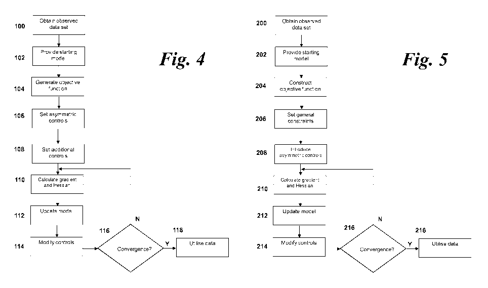
Figure 4 shows a flow diagram of a first embodiment of the present invention.
Step 100: Obtain observed seismic data set
Initially, it is necessary to obtain a set of experimentally gathered seismic
data in order to
initiate subsurface exploration. This may be gathered by an experimental
arrangement such
as the set up shown and described with reference to Figure 1.
The gathered seismic data may comprise the original data set. Alternatively,
the gathered
seismic data may optionally be pre-processed in various ways including by
propagating
numerically to regions of the surface or subsurface where experimental data
have not been
acquired directly. Alternatively, the gathered seismic data may be pre-
processed utilising
filters or other pre-processing elements to remove extraneous noise or
background
interference, for example. The skilled person would readily be able to design
and undertake
such pre-processing as might be necessary or desirable. With or without such
pre-
processing, the resultant seismic dataset representing experimentally-gathered
data is known
as an "observed seismic data set".
CA 02987521 2017-11-28
WO 2016/193179 PCT/EP2016/062091
14
As shown in Figure 1, a large number of receivers or detectors 16 are
positioned at well
known positions on the surface of the portion of the Earth to be explored. The
detectors 16
may be arranged in a two dimensional (such as a line) or a three dimensional
(such as a grid
or plurality of lines) arrangement. The physical location of the detectors 16
is known from, for
example, location tracking devices such as GPS devices. Additionally, the
location of the
source 12 is also well known by similar location tracking means.
The observed seismic data set may comprise multiple source 12 emissions known
in the art
as "shots". The data comprises pressure as a function of receiver position (on
the x-axis) with
respect to time (on the y-axis). This is because, in general, a detector such
as a hydrophone
measures the scalar pressure at its location. However, other arrangements may
be used.
The seismic trace data comprises a plurality of observed data points. Each
measured
discrete data point has a minimum of seven associated location values ¨ three
spatial
dimensions (x, y and z) for receiver (or detector) position (r), three spatial
dimensions (x, y, z)
for source location (s), and one temporal dimension measuring the time of
observation
relative to the time of source initiation, together with pressure magnitude
data. The seven
coordinates for each discrete data point define its location in space and
time.
The seismic trace data also comprises one or more measurement parameters which
denote
the physical property being measured. In this embodiment, a single measurement
parameter,
pressure is measured. The observed data set is defined as d(r,$) and, in this
embodiment, is
in the time domain. For clarity, the following discussion considers a single
source-receiver
pair and so r, s are not needed.
The actual gathering of the seismic data set is described here for clarity.
However, this is not
to be taken as limiting and the gathering of the data may or may not form part
of the present
invention. The present invention simply requires a real-world observed seismic
data set upon
which analysis can be performed to facilitate subsurface exploration of a
portion of the Earth.
The method now proceeds to step 102.
Step 102: Provide starting model
At step 102, an initial starting model of the specified subsurface portion of
the Earth is
provided. The model may be provided in either a one dimensional, a two
dimensional or a
three dimensional form. Whilst the illustrated examples are of a two-
dimensional form, the
CA 02987521 2017-11-28
WO 2016/193179 PCT/EP2016/062091
skilled person would be readily aware that the present invention is applicable
to three
dimensional approaches.
The generated model consists of values of the coefficient Vp and, possibly,
other physical
5 values or coefficients, typically defined over a discrete grid
representing the subsurface. Such
starting models are routinely generated and represent the general trends of
the major
features within the subsurface region to be modelled and could be readily
generated by the
skilled person. However, in the case of the present invention a less accurate
initial model
could be used. This may reduce the required time and resources to generate the
starting
10 model whilst still enabling accurate and improved -because the final
model quality is superior
in terms of sharpness of discontinuities- convergence.
The starting model may vary depending upon the inverse problem formulation
used. For
example, with conventional FWI, a predicted seismic data may be generated
based on an
15 analysis of the acoustic isotropic two-way wave equation as set out
below in equation 3):
02 p 1
3) pV (VP) = s
V2 at2
where the acoustic pressure p and driving source s vary in both space and
time, and the
acoustic velocity Vp and density p vary in space. This equation applies to
small-amplitude
pressure waves propagating within an inhomogeneous, isotropic, non-
attenuating, non-
dispersive, stationary, fluid medium. It is relatively straightforward to add
elastic effects,
attenuation and anisotropy to the wave equation. Introduction of these
parameters changes
the detailed equations and numerical complexity, but not the general approach.
The wave equation 3) represents a linear relationship between a wave field p
and the source
s that generates the wave field. After discretisation (with, for example,
finite differences) we
can therefore write equation 28) as a matrix equation 4):
4) Ap = s
where p and s are column vectors that represent the source and wavefield at
discrete points
in space and time, and A is a matrix that represents the discrete numerical
implementation of
the operator set out in equation 5):
1 02 1
5) A = ___ Ot2 pV (¨V)
V2
CA 02987521 2017-11-28
WO 2016/193179 PCT/EP2016/062091
16
Although the wave equation represents a linear relationship between p and s,
it also
represents a non-linear relationship between a model m and wavefield p. Thus
equation 5)
can be rewritten as equation 6):
6) 13(m)=P
where m is a column vector that contains the model parameters. Commonly these
will be
the values of Vp (and p if density is an independent parameter) at every point
in the model,
but they may be any set of parameters that is sufficient to describe the
model, for example
slowness 1/Vp, acoustic modulus V,2 p, or impedance V, p.
In equation 6), B is not a matrix. Instead it is a non-linear Green's function
that describes how
to calculate a wavefield p given a model M.
Once the model has been generated, the method then proceeds to step 104.
Step 104: Generate objective function
At step 104, an objective (or misfit) function to be minimised is configured.
Any suitable
method may be used as required. For example, any of the FWI or AWI methods
described
earlier could be used with the present invention. In general, an objective
function of the form:
7) F (m) = f (do, d(m), m, A, p, s, . . . )112
could be used, where the objective function can depend on the observed and
predicted data,
model parameters, wave equation operator, predicted wavefield, source and
other terms.
The specifics of this approach may vary in dependence upon the method used to
iteratively
solve the inverse problem. All applicable methods are considered to form part
of the present
invention.
For example, in the case of conventional FWI, the objective function is
operable to compare
the difference between the measured data set and a predicted seismic data set.
Therefore, it
is necessary to generate a predicted data set from the initial starting model
created in step
102.
CA 02987521 2017-11-28
WO 2016/193179 PCT/EP2016/062091
17
The predicted data is required to correspond to the same source-receiver
location data
positions as the actual measured trace data so that the modelled and observed
data can be
compared. In other words, the predicted data set corresponds discrete point to
discrete point
to the observed dataset. The predicted data set is generated for the same
measurement
parameter(s) at the same frequency or frequencies.
From the above analysis, predicted seismic data can be generated for one or
more physical
parameters in the time domain. If done in the frequency domain it could be
done for one or
more selected frequencies. Other domains may also be used to generate the
data, for
example the Laplace domain or the frequency-wavenumber domain. This forms the
predicted
seismic data set which is utilised as d(m).
In the case of AWI, an example of an objective function may be configured to
measure the
similarity or dis-similarity between a simple one-dimensional convolutional
filter in time and a
reference function that consists of only one non-zero value at zero lag.
The convolutional filter takes as an input all or part of the predicted data
and from that
generates as an output an approximation to all or part of the observed data. A
filter is
designed for each source-receiver pair to generate a set of coefficients
specific to particular
values. More than one filter may be designed in this step if required.
It is to be understood that the term "convolutional filter" in the present
invention may have
broad applicability. For example, the convolution may be non-causal, involve
non-stationary
convolution operations, or it may be applied in one or more dimensions,
including spatial,
temporal or other dimensions, the number of dimensions and/or number of data
points on
input need not the same as the number of dimensions or data points on output,
the filter may
vary in space, in time and/or in other dimensions, and it may involve post-
processing
following convolution.
The convolutional filter may comprise any generalised convolutional operation
that can be
described by a finite set of parameters that depend upon both the predicted
and observed
data, such that when the convolution and associated operations are applied to
all or part of
the predicted data an accurate or generally approximate model of the observed
data is
generated.
CA 02987521 2017-11-28
WO 2016/193179 PCT/EP2016/062091
18
Based on the above, the objective function would then consist of some norm of
these
weighted coefficients divided by the same norm of the unweighted coefficients.
If the L2 norm
is used here, then this objective function will provide the least-squares
solution, but other
norms (for example, the L1 norm) are potentially utilisable.
The norm of the weighted coefficients must be normalised by the norm of the
unweighted
coefficients in this example otherwise the objective function could be simply
minimised by
driving the predicted data to large values, and hence driving the filter
coefficients to small
values.
In this example, the coefficients generated for each source receiver pair are
weighted as a
function of the modulus of the temporal lag. In other words, the coefficients
are weighted
based on the data position in time for a time domain analysis.
However, it is to be understood that other types of weighting could be used.
For example,
more complicated functions of the temporal lag are possible such as weighting
with a
Gaussian function of lag centred on zero lag.
In general two types of weighting are desirable; those that increase
monotonically away from
zero lag, such as the modulus, and those that decrease monotonically away from
zero lag,
such as a Gaussian weighting. The former type of weighting will lead to
objective functions
that should be minimised and the latter type will lead to objective functions
that should be
maximised. Combinations of these two types are also possible. The skilled
person would
readily understand how to design such objective functions and how to minimise
or maximise
them.
The method proceeds to step 106.
Step 106: Set asymmetric controls
At step 106, asymmetric controls are added to the objective function
formulation. The controls
are either in the form of constraints (where a given parameter may not exceed
a particular
constraint value) or penalties (where a given parameter may exceed a
particular threshold but
is increasingly penalised the more it exceeds the threshold. In this example,
both constraints
and penalties are disclosed.
CA 02987521 2017-11-28
WO 2016/193179 PCT/EP2016/062091
19
The controls are imposed by a regulariser that constrains the total variation
of the physical
model parameters per iteration along specified directed paths through the
model, where the
directed paths are defined in relation with the model spatial locations. In
other words, the
directed paths are defined in relation to the spatial geometry of the model.
For example, a
model parameter is only allowed to increase in some specified directed path
through the
model.
There may be one or more directed paths, and they may take any suitable form.
For example,
the directed paths may be straight lines, curves or a combination of the two.
The directed
paths may be configured to follow particular geometrical or geophysical
features or aspects f
the model, or they may be simple straight lines in a particular direction. For
example, the
directed paths may extend vertically through the model. In general, the
vertical direction in the
model will correspond to the gravitational direction in the real-world
subsurface portion of the
Earth that the model is intended to correspond to.
Inverse problems are often posed and iteratively solved without any
assumptions about the
parameters of the model which are unknown. However, regularisation in the form
of
constraints or penalties on the parameters of m can be used to enforce
assumptions to assist
the iterative convergence process.
In this example, m denotes medium parameters of the model on a spatial grid,
represented
as a vector m E RN, where N is the number of model parameters. In the context
of acoustic
waveform inversion, m could represent the square of slowness, or the
reciprocal of the
square of the velocity.
Therefore, since the velocity generally increases with depth, a constraint can
be placed on m
that penalises increases in slowness in the direction of increasing depth. As
a result,
downward jumps in velocity can be penalised. This can be done with an
asymmetric, one
dimensional total variation constraint that places pre-selected bounds on
increases in the
slowness or some function of slowness in the increasing depth direction.
Similarly, the
asymmetric total variation constraint can restrict decreases in velocity or
some function or
velocity.
The asymmetric constraints can be imposed, for example, as regularisers with a
general form
(set out in expression 8):
CA 02987521 2017-11-28
WO 2016/193179 PCT/EP2016/062091
8) m c
where Dv is a difference matrix such that DR) is a particular discretisation
of the directional
5 derivatives Vm.v at each grid point, where v is the direction of the
directed path, so that Dv is
the derivative along the directed path; and max(0,=) is interpreted in a
component-wise sense.
The strength parameter controls the total amount of asymmetric total variation
allowed in
the direction v.
10 Using this formulation, particular biases can be imposed on the
minimisation of the objective
function. For example, the vector field v could be configured to have a bias
in the direction of
increasing depth. In the described example, where the downward jumps in
velocity are
penalised in the depth (vertical) direction, the derivative operator Dv would
be D.
15 This
has multiple benefits. Having single-direction constraints enables the
minimisation to be
guided in a specific directed path through the model which is beneficial to
reaching a more
accurate model update. The effect of imposing such constraints is a
restriction in the solution
space (or objective function) allowed positions. That is, only models that
obey the constraints
are allowed, effectively reducing the size of the solution space, with the
assumption that by
20 discarding models with less physical likelihood we will reduce the
number of local minima.
This approach, however, does not ensure elimination of all local minima from
the solution
space.
The relative strength of the asymmetric constraint can be varied as
appropriate. The
parameter controls the strength of the constraint. If = 0, then m is not
allowed to increase
in the direction v. For
> 0, the sum of the non-negative directional derivatives in the v
directions evaluated at each spatial location must be less than or equal to
Note that v does
not need to be constant through the model, and can represent any path through
it.
Incorporating the directional derivative constraint into the generic inverse
problem 7) leads to
a minimisation of:
;
The type of asymmetrical or directional constraints which are imposed upon the
objective
function may be selected as required and may relate to one or more parameters
of the model
CA 02987521 2017-11-28
WO 2016/193179 PCT/EP2016/062091
21
m as desired. The skilled person would be readily aware of the parameters
which could be
constrained.
In addition, whilst the above example has been illustrated with respect to the
one-directional
constraint on velocity with increasing depth, other arrangements could be
contemplated. For
example, an asymmetric directional constraint could be used to add
regularisation to the
sides of the model, where there are often artefacts due to limited data
capture. Near the sides
of the model, an asymmetric TV constraint could also be implemented in the
horizontal
direction.
Further, vector fields could be defined that account for more complicated
structural
assumptions. For example, if a point is considered to lie on a surface of
substantially constant
velocity, and the normal direction to this surface is known, then two
orthogonal directions
could be selected and two one directional TV constraints applied in these
directions, with the
aim of discouraging changes in velocity in directions that are tangent to the
surface.
It is also possible for F to depend on additional variables not subject to the
above constraints.
For example:
10) min F (m, y) +q(y) s.t. 11 max(0, Dv TO 11
m,y
This can also include convex constraints on y if 0 is an indicator function
that is zero when the
constraint is satisfied and infinite otherwise.
A further alternative to the asymmetric constraint is a directional derivative
shifted asymmetric
constraint which only penalises differences larger than a threshold:
11) 11 ax(0, Dvm ¨ c)
Another alternative is to set the asymmetric constraint as a penalty term
added to the
functional, where positive changes (or negative changes) in the specified
direction are
allowed but they increase the total value of the functional. Therefore, the
inverse problem will
prefer solutions where the penalty term is minimised.
The method may proceed, optionally, to step 108. Alternatively the method may
proceed
directly to step 110.
CA 02987521 2017-11-28
WO 2016/193179 PCT/EP2016/062091
22
Step 108: Set additional controls
In addition to the asymmetric controls set out above in step 106, other
constraints or penalties
(i.e. controls) may also be introduced. This may be advantageous in particular
situations and
may assist in, for example, noise reduction or artefact elimination.
The additional constraints may comprise bound constraints, for example:
12) rai E ffil
where bl and Blare the lower and upper bounds of the Ith model parameter
respectively. Such
bounded constraints may be based on empirical knowledge or on physical models
which
maintain particular values within reasonable physical ranges.
Additionally or alternatively, the applied constraints may comprise total
variation constraints,
such as set out in expression 13) below:
13) <
where Z is the size of the TV ball. This expression may also be written
aslIamil
1,2
which
equals Et ' 1
, i.e. a sum of the /2 norms of the discrete gradients of m summed over all
the spatial grid points or over all the discrete or continuous locations in
the model. Such an
isotropic TV constraint is particularly useful for limiting artefacts caused
by directional
constraints.
Additionally or alternatively, directional TV constraints of the form IID
representing a
discretisation of the directional derivatives, and limiting the total
variation of m in the direction
v. This equally penalises increases and decreases of m in the v direction.
Once the additional constraints have been added if required, the method
proceeds to step
110.
Step 110: Calculate functional gradient and optional Hessian
CA 02987521 2017-11-28
WO 2016/193179 PCT/EP2016/062091
23
This step may be done by any suitable method. In conventional FWI, a predicted
data set is
generated from the model and the objective function is then used to determine
a residual
from the differences between the observed data set and the predicted data set.
The gradient
is then calculated, for example using an adjoint state method. If implemented,
the Hessian
can be approximated in a variety of ways, for example we can use the diagonal
elements only
of some approximation to the full Hessian.
The gradient direction and a Hessian approximation can be derived from the FWI
functional
by, for example, following the method described subsequently in relation to
step 210.
In the case of the AWI method, the method seeks to minimise the misfit between
the
convolutional and reference filters. In one embodiment, the gradient of the
objective
functional is obtained with adjoint-state methods, minimising the weighted
filter coefficients.
The method proceeds to step 112.
Step 112: Update model
Once the gradient direction and Hessian, approximations or exact if
affordable, are
computed, the method proceeds to calculate the model update.
In each case, multiple approaches to can be used to find local minimisers of
the nonconvex
optimisation problem.
14) min F (m) s.t. m e C j = 1, J
171
where F is differentiable and C.] are convex and represent the different
constraints imposed in
to the objective function. One advantageous approach is a scaled gradient
projection (SGP),
which is an implementation of majorisation minimisation to reduce F(m) while
satisfying the
constraints specified in steps 106 and 108.
A generic majorisation minimisation approach would proceed by constructing at
the current
model estimate Mk an upper bound Gk(rn)F(rn) such that Gk(rnk)F(rnk). By
letting:
15) mk+1 = argminGk (m)
mEc3
CA 02987521 2017-11-28
WO 2016/193179 PCT/EP2016/062091
24
It follows that:
16) F(nk+i) < G(nk+i) < G(nk) F(nk)
and Mk+1 C. If the C are convex sets and the Gk are convex functions, then
each iteration
k requires solving a convex sub-problem for which many efficient and known
methods are
available.
While arbitrary Gk satisfying the above conditions does not guarantee
convergence of Mk ,
specific selection may do so. For example, if VF is Lipschitz continuous then
VF(mk) can be
used with a positive definite approximation Hk to the Hessian of F at Mk to
define a quadratic
approximation:
17) Qk(rn) F(rnk) @n, mk, vF(nk)\ _1 Irn mk, Lik( rri
2 \ ¨ k)
An alternative approach is to use scaled gradient projection (SGP) which
consists of iterating:
18) Trtic+1 = argmin Qk(M)
TraeCi
This approach will converge if it is ensured that the smallest eigenvalue of
Hn is sufficiently
large. The method can still converge even when Qn is not an upper bound of F.
Hn can also
be adaptively scaled to prefer large step sizes while keeping the step size
small enough to
guarantee sufficient descent of F and thereby to guarantee convergence to a
stationary point.
Alternative methods may be used. For example, a Lagrangian based algorithm
such as the
method of multipliers, a quadratic penalty method or a hybrid of the two could
be used to
devise iterative schemes that solve easier sub-problems that only require the
Mk+1 iterates to
approximately satisfy the constraints. If the projections onto the C., are
expensive, this could
be valuable.
For any useful measure of misfit or similarity, the predicted seismic data set
will move
towards the observed seismic data set. The underlying assumption is that when
the predicted
data move towards the observed, the updated models converge towards the model
that
represents the real Earth's subsurface. This assumption will be satisfied
provided that the
objective function definition and the constraints are correctly set to avoid
falling in local
minima.
CA 02987521 2017-11-28
WO 2016/193179 PCT/EP2016/062091
The method now proceeds to step 114.
Step 114: Modify controls
5
At step 114, it is determined whether the controls should be modified before
the next iteration
of the method. This step is optional and need not be included, in which case
the constraints
set in step 108 or in steps 108 and 110 remain the same for further
iterations.
10 By modifying the constraints and/or penalties with each iteration or
group of iterations, the
iterative process can be guided to better solutions by adjusting the
constraints as the method
proceeds. For example, the constraints and/or penalties may be set to be
strong or restrictive
for early iterations to ensure that the model updates progress in a particular
direction, with the
constraints being relaxed as the iteration progresses.
This has advantages in numerous applications. For example, consider the
situation where an
inverse problem approach is utilised to recover earth models including high
velocity salt
bodies. If the initial velocity model is not highly accurate, conventional FWI
methods would
tend to converge to local minima that may correctly identify the top of the
salt body but not the
bottom region. Such methods tend to be bad local minimisers that place the
bottom of the salt
body too high or that are dominated by spurious artefacts, such that sensible
results are not
derived below the top boundary of the salt body.
The asymmetric directional derivative constraint in the depth direction
prevents the method
from getting stuck in these local minima by discouraging downward jumps in
velocity. With a
strong asymmetric constraint, this has the effect of extending the high
velocity salt region
downward. This, therefore, provides an automated approach to the manual
process of "salt
flooding" where velocities are directly manipulated to extend them downward.
However, it may not be desirable to maintain a strong constraint through all
the iterations
because it would then be impossible to recover fine details in the model at
later iterations.
Therefore, a process may be implemented whereby the constraint is relaxed
according to a
continuation strategy that slowly increases the parameter with each iteration
of the method
thus relaxing the asymmetric TV constraint as iterations proceed and allowing
the updates to
introduce more structure in the model.
CA 02987521 2017-11-28
WO 2016/193179 PCT/EP2016/062091
26
This forces early velocity models to be nearly monotonically increasing in
depth, while more
downward jumps are allowed during later iterations. This improves the solution
path so that
the method avoids local minima. This applies particularly to regions just
below the top of a
salt body. Moreover, this approach still allows fine details to be modelled in
later iterations
when the constraint is weaker.
However, there is a trade-off between the effectiveness of this approach and
the expense of
the continuation strategy with increasing iteration. Increasing slowly is more
effective for
avoiding poor and inaccurate local minima but also more computationally
expensive.
One optional approach to implementing the changes with iteration is to utilise
both a TV
constraint and an asymmetric directional derivative constraint.
Consider a TV constraint llDrnll -rv
and an asymmetric directional derivative constraint
Ilmax(0,D. 771' .1 A sequence of parameters T5 and b can be defined, where
b indexes
the stage of the strategy (b may or may not correspond directly to the
iteration step k). Based
on this, for parameters r>0, > 1, > 0 and 71, > 1 it can be defined:
19) _
¨ WIT
And
20)_ b
Eb Ellns
For each b, some number of iterations can be computed before the T and values
are
recalculated and increased before the next iteration.
If ??, = 71 = 1 then no variations occur with each iteration and To and
are used for all
iterations.
The procedure of relaxing the constraint parameters with increasing k
iterations can also be,
optionally, combined with a frequency continuation strategy. For example, this
may result in
an implementation where, for each b, only low frequency data is fitted at
first, with the method
gradually including higher frequencies as the iterations proceed.
CA 02987521 2017-11-28
WO 2016/193179 PCT/EP2016/062091
27
The values for may be estimated based on empirical data, or on known
parameters of the
model. The starting values for the constraint parameters are generally
selected to be small
(i.e. to provide a strong constraint) and are then increased at a particular
rate.
The rate of increase may be selected to follow a particular algorithm or
function. For example,
the parameters may be increased at an exponential rate with each kth
iteration. This may
result in the final parameters being twice as large as the initial parameters.
Alternatively, the
change in and/or T may follow another function, or may be tied to particular
parameter value
(e.g. some form of the residual or other error bound).
Whilst, empirically, it has been found to be advantageous to start with strong
constraints and
increase the parameters slowly for the initial iterations, this need not be
so. For particular
systems, it may be more appropriate to start with weaker constraints and then
focus them
down to a stronger system in later iterations.
In addition, the TV constraint need not be varied and need not start with a
small parameter
value, since the TV constraint is, in one embodiment, implemented to prevent
artefacts
caused by the asymmetric constraint.
The method proceeds to step 116.
Step 116: Convergence criteria met?
At step 116 it is determined whether convergence criteria have been met. For
example, when
the method is deemed to have reached convergence when the difference between
the data
sets (or the residual in each case) reaches a threshold percentage or other
value.
Alternatively, the stopping criterion may be a maximum number of iterations;
or any general
combination of the two above-mentioned criteria. If the criteria as set out
above have been
met, then the method proceeds to step 118 and finishes with the resultant
Earth model
generated. If the criteria have not been met, then the method proceeds back to
repeat steps
110 to 114 as discussed above for a k-F1th iteration.
Step 118: Finish
When, at step 118, it has been determined that the convergence criteria has
been met, the
method finishes and the modelled subsurface portion of the Earth is deemed to
be sufficiently
CA 02987521 2017-11-28
WO 2016/193179 PCT/EP2016/062091
28
accurate to be used for subsurface exploration. This may involve the direct
interpretation of
the recovered model, and/or involve the process of depth-migration to generate
a subsurface
reflectivity image to be used for the identification of subsurface features
such as cavities or
channels which may contain natural resources such as hydrocarbons. Examples of
such
hydrocarbons are oil and natural gas.
Once these features have been identified in the subsurface model and/or
reflectivity image,
then measures can be taken to investigate these resources. For example, survey
vessels or
vehicles may be dispatched to drill pilot holes to determine whether natural
resources are
indeed present in these areas.
A second embodiment of the invention is illustrated in Figure 5. The second
embodiment
details a specific, non-limiting example of the process in detail.
Step 200: Obtain observed seismic data set
Step 200 corresponds substantially to method step 100 of the previous
embodiment.
Therefore, this will not be described again here. Only the steps that are new
to this
embodiment of the method of the present invention will be described. The
method now
proceeds to step 202.
Step 202: Provide starting model
At step 202, an initial starting model of the specified subsurface portion of
the Earth is
provided. The model may be provided in either a one dimensional, a two
dimensional or a
three dimensional form. Whilst the illustrated examples are of two-dimensional
form, the
skilled person would be readily aware that the present invention is applicable
to approaches
utilising other dimensional forms.
The model is generated in this step in accordance with step 102 above.
In this example, which uses a FWI approach, the initial starting model is a
best guess
estimate for the subsurface region to be modelled. This includes parameters of
the model
which are to be inputted into the resulting partial differential equations
(PDEs) to describe the
response of the model to a source excitation modelled by the source function
s,.
CA 02987521 2017-11-28
WO 2016/193179 PCT/EP2016/062091
29
The generated model consists of values of the parameter Vp and, possibly,
other physical
values or coefficients over a discrete grid representing the subsurface. Such
starting models
are routinely generated and represent the general trends of the major features
within the
subsurface region to be modelled and could be readily generated by the skilled
person.
The method then proceeds to step 204.
Step 204: Construct objective function
At step 204, an objective (or misfit) function is configured. In this
embodiment, the method of
Full Waveform Inversion (FWD is utilised. This is based upon a wave equation
written as a
PDE which describes the wavefield resulting from the external excitation (the
source).
The objective function for FWI is:
1
21) F(m) = ¨11Mp ¨ doe
2
The model m corresponds to the reciprocal of the velocity squared, to be a
real vector m c RN
where N is the number of points in the spatial discretisation. M is the
operator that projects
the wavefields onto the receiver locations. There is an implicit sum over all
sources and
receivers for the objective function.
The method then proceeds to step 206.
Step 206: Set general constraints
To make the inverse problem more well posed, the constraint m c c can be
added, where C
is a convex set. Expression 22) can then be solved.
22) -a = C
For example, a box constraint on the elements of m could be imposed by setting
Cbox = frn: rni
[b1,B1]}. The only modification of expression22) is to replace the Am update
by:
1
23) Am =--argmin AmTVF(rnk) + -AmTHkAm
7nERN 2
s.t. mk + Arrl E Cbox
CA 02987521 2017-11-28
WO 2016/193179
PCT/EP2016/062091
Total variation (TV) constraints can also be added to the discretised model.
If m is
represented as an N1 x N2 image, a TV constraint can be defined as:
5 24) 111 = n )2
h
which represents a sum of the /2 norms of the discrete gradient at each point
in the
10 discretised model, with the assumption that Neumann boundary conditions
apply so that
these differences are zero at the boundary. l ITT can be expressed more
compactly by
defining a difference operator D such that Dm is a concatenation of the
discrete gradients and
(Dm)n denotes the vector corresponding to the discrete gradient at the
location indexed by n,
where n =1, ..., N N2:
25)
:=
The constraints of
[E.1 and 11n2IITV r are then added, providing a TV constrained
problem to be solved of:
11 ,1 S.t.
26)
A weighted TV constraint could also be applied if required, where different
parts of the model
have different relative contributions to the TV norm, by introducing a
diagonal matrix in front
of the derivative matrix D, where the values of the diagonal entries in the
new matrix control
the relative contribution.
The method proceeds to step 208.
Step 208: Introduce asymmetric controls
At step 208, asymmetric controls are added. These may apply to velocity since,
for example,
velocity generally increases with depth. Therefore, an asymmetric control may
be introduced
which penalises downward jumps in velocity without affecting upward jumps in
velocity with
CA 02987521 2017-11-28
WO 2016/193179 PCT/EP2016/062091
31
each iteration. In this example, an asymmetric, one dimensional total
variation constraint is
used which penalises increases in the slowness squared in the depth direction.
The constraint:
27)
is introduced, where "max" is understood to relate to particular components
such that
28) ¨
The constraint in expression28) does not penalise velocities in the horizontal
direction, only in
the vertical (depth) direction.
Positive depth weights may also be utilised such that:
29)
where 7, is a weight parameter that depends on depth position i. The rationale
for adding
weights is that in the deeper regions of the model the value of the parameter
m (slowness
squared) is smaller than in the shallow parts because typically seismic
velocities increase
with depth. Increasing the value of the weights with depth helps balance the
contribution
deficit of the deeper parts of the model to the asymmetric total variation
constraint.
Further, the use of such weights may have advantages in terms of encouraging
deeper
placement of discontinuities when the weights are designed to overcompensate
for the above
mentioned contribution deficit,.
In addition, the constraints can be varied with each iteration. This is known
as a continuation
strategy. The parameter can vary with some or all of the iterations. For
example, may start
in early iterations (where k is small) with a small value (e.g. 0 or close to
zero) such that m is
totally or heavily constrained in one direction for one or more parameters.
CA 02987521 2017-11-28
WO 2016/193179 PCT/EP2016/062091
32
As the iterations continue (with higher k values), the value of the parameter
may be allowed
to increase gradually for each successive iteration (e.g. each low to high
pass through the
frequency batches). In other words, the asymmetric constraint is relaxed as
the iteration
continues, which encourages the initial velocity estimate to be nearly
monotonically
increasing in depth initially. As increases, more downward jumps are allowed.
A continuation strategy may be implemented such that the
parameter is varied in
accordance with a measured parameter (for example, the residual in a
particular direction or
orientation).
Once the asymmetric controls have been implemented, the method proceeds to
step 210.
Step 210: Calculate functional gradient and optional Hessian
A first step in FWI is to find the solution of the PDE that represents the
wave equation that
generates the predicted data utilised by the objective function in equation
21). This step
consists of solving the wave equation using numerical methods.
The gradient of the FWI objective function at iteration k is:
30) VmF(Trik) = p(m,k)T (aarnA)T A-T(mp(rrik) do)
and the Hessian approximation for the FWI objective function we will use has
the form:
31) Hk p(mk)T (aA T (aAp(rnk)
am) am)
where equation 31) only populates the diagonal of a simplified version of the
full Hessian.
Ultimately gradients and Hessians from separate shots are combined (summed) to
obtain a
unique gradient and Hessian for the model update..
The method then proceeds to step 212.
CA 02987521 2017-11-28
WO 2016/193179 PCT/EP2016/062091
33
Step 212: Update model
At step 212, the model is updated using the values obtained in step 210 as
constrained by
the asymmetric constraint plus any other constraints set in steps 208 and 206
respectively.
To update the model, it is necessary to solve a convex sub-problem . That is,
given a gradient
direction, a Hessian and a starting model Mk, an update Am is sought such that
the updated
model Mk+1 = Mk + Am satisfies the various constraints specified (box, TV and
asymmetric
TV). The convex sub-problem can be posed as follows:
¨1
31) Am =argmin AinT V
F (mk ) AlitT (Hk ckI)A711
A rn 2
s.t. m Am, E [bi/ Bi] / 11711k Am1lTv < T
and Ilmax(0, D z (mk Arn)11
An effective approach is to use a modification of the primal dual hybrid
gradient (PDHG)
method to find a saddle point of:
32) r(Am, Al, A2) =ATT-tTVF(mk) AmT(Hk ck nAm gB(rnk Am)
ArD(Trbk Am) ¨ T A11100,2
+ (mk Am) ¨ max(A2) ¨ g>o (A2)
where 2/ and 22 represent the Lagrange multipliers for each TV constraint, the
regular and
the asymmetric respectively.
The new terms introduced in equation 32) are described below, where gB(m) is
an indicator
function for the bound constraints as defined below:
33) 0 if mi E [bi,
g B (m) =
oc otherwise
and g>0 denotes an indicator function defined by:
0 if A2 >O
34) g>o(A2) =
Do, otherwise
CA 02987521 2017-11-28
WO 2016/193179 PCT/EP2016/062091
34
The 11 = 1100,2 term is using mixed norm notation to denote the dual norm 11 =
111,2. This approach
takes the maximum instead of the sum of the /2 norms so that 11 Dm 16,2 = max
n 11 Dm 11.
The total variation (TV) constraints are introduced in the saddle point
problem (Lagrangian)
as Lagrange multipliers. For the first constraint, associated with Å we can
write:
35) sup ATD(mk Am) ¨
which equals the indicator function:
36) 0 if 11D(mk + Arn) 11,2
< 7
po, otherwise
For the second constraint, associated with 22:
37) sup ATD,(mk Am) ¨ '.max(A2) ¨ g > o (A2)
A2
which equals the indicator function:
38) 0 if Ilmax(0, D z (mk
AT11)11
otherwise
The indicator functions described above can be interpreted as a form of strict
penalties,
where the saddle problem solution has to be such that the value of the
indicator functions is
always zero, therefore enforcing the constraints to be satisfied.
To find a saddle point of 32), the modified PDHG method requires iterating
Aj1+1 =Atil D (mk + Amq) ¨
q+ D (mk + Amq))
39)
.==A D (mk + Amq) ¨ m(0).)111<0 D z (mk + Amq))
Ilax
Amr1 =max ((bi ¨ m ), min((Bi ¨
1 ATO
[(Hk (ck )i)-1( vonk) ______
a a
DT(2A7+1 ¨ A7) ¨ DzT(2A+1 ¨ ))
CA 02987521 2017-11-28
WO 2016/193179 PCT/EP2016/062091
where q is the iteration index and the fI symbols are projection operators
onto the TV bounds
corresponding to each constraint. The values of a and 6 control the step size
of the updates.
5 For any useful measure of misfit or similarity, the predicted seismic
data set will move
towards the observed seismic data set consistently with the objective function
misfit definition.
The underlying assumption is that when the predicted data move towards the
observed, the
updated models converge towards the model that represents the real Earth's
subsurface.
This assumption will be satisfied provided that the objective function
definition and the
10 constraints are correctly set to avoid falling in local minima.
The method now proceeds to step 214.
Step 214: Modify constraints
As set out for step 114, at step 214 it is determined whether the constraints
should be
modified before the next iteration of the method.
By modifying the constraints with each iteration or group of iterations, the
iterative process
can be guided to better solution by adjusting the constraints as the method
proceeds. For
example, the constraints may be set to be strong or restrictive for early
iterations to ensure
that the model updates progress in a particular direction, with the
constraints being relaxed as
the iteration progresses.
The asymmetric directional derivative constraint in the depth direction
prevents the method
from getting stuck in these local minima by discouraging downward jumps in
velocity. With a
strong constraint, this has the effect of extending the high velocity salt
region downward. This,
therefore, provides an automated approach to the manual process of "salt
flooding" where
velocities are directly manipulated to extend them downward.
Once the modifications have been completed, the method proceeds to step 216.
Step 216: Convergence criteria met?
At step 216 it is determined whether convergence criteria have been met. For
example, when
the method is deemed to have reached convergence when the difference between
the data
CA 02987521 2017-11-28
WO 2016/193179 PCT/EP2016/062091
36
sets reaches a threshold percentage. Alternatively, the stopping criterion may
be a maximum
number of iterations; or any general combination of the two above-mentioned
criteria. If the
criteria as set out above have been met, then the method proceeds to step 218
and finishes
with the resultant Earth model generated. If the criteria have not been met,
then the method
proceeds back to repeat steps 210 to 214 as discussed above.
Step 218: Finish
When, at step 218, it has been determined that the convergence criteria has
been met, the
method finishes and the modelled subsurface portion of the Earth is deemed to
be sufficiently
accurate to be used for subsurface exploration. This may involve the direct
interpretation of
the recovered model, and/or involve the process of depth-migration to generate
a subsurface
reflectivity image to be used for the identification of subsurface features
such as cavities or
channels which may contain natural resources such as hydrocarbons. Examples of
such
hydrocarbons are oil and natural gas.
Once these features have been identified in the subsurface model and/or
reflectivity image,
then measures can be taken to investigate these resources. For example, survey
vessels or
vehicles may be dispatched to drill pilot holes to determine whether natural
resources are
indeed present in these areas.
An example of the effectiveness of the method of the present invention is
shown with respect
to Figures 6 to 9. Figure 6a shows a target model and Figure 6b shows a poor
initial model
which is to be used as a starting model for the following inversion processes.
Figures 7a and 7b show the results of a number of iterations of an inversion
method without
any regular total variation (TV) or asymmetric TV constraints. The method
starts from the
initial model of Figure 6b. Figure 7b shows the result after twice the number
of iterations of
the result shown in Figure 7a. As shown, the quality of the resolved model is
poor and it is
clear that the model is not converging to a correct global minimum.
A further example is shown in Figures 8a to 8c. Figures 8a to 8c show the
results of an
inversion method in which regular (two-sided/symmetrical) TV constraints are
applied. Again,
the method starts from the model of Figure 6b.
CA 02987521 2017-11-28
WO 2016/193179 PCT/EP2016/062091
37
Figure 8a show the result for a strong value of the TV constraint. Figure 8b
show the result
after a subsequent iteration after relaxing the TV constraint. Finally, Figure
8c show the result
after yet another subsequent iteration after relaxing again the TV constraint.
As shown, the
results are improved with respect to the previously-described model. In
particular, the upper
region of the target salt body is resolved. However, deeper, high velocity
elements of the salt
body are not correctly resolved.
Finally, Figures 9a to 9f show subsequent iterations using the method of the
second
embodiment in which one-sided (or asymmetric) constraints are implemented in
accordance
with the present invention. As shown, the method clearly converges to an
accurate final
model which is close to the target model.
As shown in these examples, without the use of constraints, an iterative
inversion problem
relies upon having a good initial starting model to reach an accurate
convergence. In general,
a method without any constraints tends to get stuck at local minima. This is
rarely improved
when using just bound constraints or TV constraints. Therefore, to address
these problems
and discourage the iterative method getting stuck in local minima that have
spurious
downward jumps in velocity, the asymmetric TV constraint approach of the
present invention
can be utilised.
In addition, the examples shown in Figure 9 use a method which implements a
continuation
strategy whereby the parameter is varied with some or all of the iterations.
In this example,
starts with a small value and gradually increases for each successive low to
high pass
through the frequency batches. This encourages the initial velocity estimate
to be nearly
monotonically increasing in depth.
As
increases, more downward jumps are allowed. The sequence of parameters as a
fraction of ilma-:' is
chosen to be 0.01; 0.05; 0.10; 0.15; 0.20; 0.25; 0.40; 0.90
respectively. The T parameter is fixed at .9 T throughout.
Although small values of may result in additional vertical artefacts, the
continuation strategy
is effective at preventing the method from getting stuck at a poor solution.
As increases,
more downward jumps in velocity are allowed, and the model error continues to
significantly
decrease during each pass.
CA 02987521 2017-11-28
WO 2016/193179 PCT/EP2016/062091
38
Clearly, the use of the asymmetric TV constraints results in significant
improvement over the
other methods. Only the asymmetric constraint model has the ability to recover
the correct
model (as can be seen from a comparison of results between Figures 6a and 9f).
Therefore,
even with a poor initial model, the asymmetric TV constraint approach of the
present
invention is able to recover the main features of the ground model.
The selected values of the T and parameters are, in embodiments, chosen to
be
proportional to values corresponding to the true solution. Although the true
solution is not
known in advance, it may still be reasonable base the parameter choices on
estimates of its
total variation (or asymmetric TV). It is also possible to develop
continuation strategies that do
rely on any assumptions about the solution but that are still effective at
regularizing early
passes through the frequency batches to prevent the method from stagnating at
poor
solutions.
Variations on the above method fall within the scope of the present
application. For
example,the method may be implemented in which the roles of the objective
function and the
control parameter are reversed such that the control parameter is minimised
(or maximised
as appropriate) and the objective function serves as the constraint. In this
configuration, the
value of the objective function must, for example, lie above or below a
predetermined
threshold, depending upon whether the iteration is configured to minimise or
maximise. This
may be defined as one or more (or a set) of allowable values of the objective
function. For
example, these values may typically be an upper threshold for an objective
function that
measures dis-similarity, and will be a lower threshold for an objective
function that measures
similarity.
Therefore, the method may seek a model that has the lowest possible positive
variation
subject to the misfit between the observed and predicted data not being higher
than the noise
level.
Further, the present invention is also applicable to the adjoint state method
of FWI, AWI,
Travel Time Tomography or any other seismic or non-seismic inversion method.
The above embodiments may be implemented in the time domain or the frequency
domain.
In the frequency domain, the different frequency components may be extracted
in any known
method, for example, through the use of a Fourier transform. Fourier
transforms and
associated coefficients are well known in the art. Since only a few frequency
components
may be required, a discrete Fourier transform may be computed from the
inputted seismic
CA 02987521 2017-11-28
WO 2016/193179 PCT/EP2016/062091
39
trace data. Alternatively, a conventional fast Fourier transform (FFT)
approach may be used.
As a further alternative, partial or full Fourier transforms may be used. The
Fourier transform
may be taken with respect to complex or real valued frequencies.
Any number of observed data sets at one or more frequencies may be extracted.
For
example, a plurality of observed data sets may be provided having frequency
components of,
for example, 4.5 Hz, 5 Hz and 5.5 Hz. These 3 frequencies can be inverted
individually with
the output of one becoming the input of the next.
Alternatively, different domain analysis could be used. For example, time
domain analysis
could also be used.
Additionally, different types of transforms that could be used with the
present invention
comprise: directional wavelet transform; a shearlet transform; a curvelet
transform.
Further, whilst the present invention has been described with reference to a
model which
involves solving the acoustic wave equation, the present invention is equally
applicable to the
models which involve solving the visco-acoustic, elastic, visco-elastic or
poro-elastic wave
equation.
Further, whilst the example here has used the scalar parameter of pressure as
its focus (i.e.
P-waves), it is also possible (with appropriate equipment such as geophones)
to measure the
particle motion in the receiver location and so determine S-wave parameters.
Data so-
generated could then be utilised and processed in the present invention.
Embodiments of the present invention have been described with particular
reference to the
examples illustrated. While specific examples are shown in the drawings and
are herein
described in detail, it should be understood, however, that the drawings and
detailed
description are not intended to limit the invention to the particular form
disclosed. It will be
appreciated that variations and modifications may be made to the examples
described within
the scope of the present invention.