Note : Les descriptions sont présentées dans la langue officielle dans laquelle elles ont été soumises.
CA 03016216 2018-08-30
WO 2017/147682
PCT/CA2016/050323
SYSTEM AND METHOD FOR PRESCRIBING FERTILIZER APPLICATION RATES FOR
SPATIAL DISTRIBUTION OF A PRODUCT
TECHNICAL FIELD
[0001] The following relates to systems and methods for prescribing
fertilizer application
rates for spatial distribution of a product, particularly for distributing
fertilizer product in an
agricultural field.
DESCRIPTION OF THE RELATED ART
[0002] Fertilizers are widely used in agricultural applications such as
farming to supply
nutrients to the soil in order to yield crops from that soil. Efficient
application of fertilizer is
often desirable to manage both monetary and environmental costs. In some
jurisdictions,
there may also be regulations surrounding fertilizer usage, which makes such
efficiencies a
requirement.
[0003] To meet these efficiency needs, precision farming and precision
agricultural
techniques have been developed which utilize various technologies to vary the
rate of
fertilizer applied to particular fields in particular geographical areas. For
example, global
positioning systems (GPS), geographical information systems (GIS), and remote
sensing
have been utilized to apply fertilizer according to the needs of individual
soils and soil types
in these particular fields.
SUMMARY
[0004] The following provides a precision agriculture prescription system
which provides
precision agriculture prescriptions, by estimating fertilizer application
rates and providing a
prescription for spatial distribution of the selected product over a given
field(s) with a goal of
achieving an efficient use of budgeted fertilizer product(s).
[0005] The system can utilize historical and forecast weather data, as well
as remote
sensing satellite imagery to maximize the grower's budgeted fertilizer
products over his/her
fields. This can be done by assessing a vegetative index such as the
normalized difference
vegetation index (NDVI) from 1-to-many satellite images of the given field(s).
The system
can also leverage regional historical weather data to correlate prior seasons'
growth patterns
and climate effects, and regional weather forecast data to incorporate
predictive climate
impacts. A soil mineralization model can be applied by the system to prescribe
an efficient
spatial distribution down to, or lower than, the image pixel level for the
selected product(s)
over the grower's field(s), to provide an economic advantage for the grower.
- 1
CA 03016216 2018-08-30
WO 2017/147682
PCT/CA2016/050323
[0006] In one aspect, there is provided a method of generating
prescriptions for spatial
distribution of fertilizer product, the method comprising: generating a
mineralization map
using one or more soil images for a field and mineralization data; generating
vegetative
index values for one or more vegetation images for the field, using weather
information;
determining a total available fertilizer budget for the field; determining a
native soil nutrient
supply from the field using the mineralization map; and generating a
prescription map for the
field that indicates a distribution of the fertilizer product in the total
available fertilizer budget
using field patterns determined from the vegetative index values, and taking
into account the
native soil nutrient supply determined from the mineralization map, and the
weather
information.
10007] In another aspect, there is provided a computer readable medium
comprising
computer executable instructions for performing the method.
[0008] In yet another aspect, there is provided a precision agriculture
system comprising
a processor that can reside on a server, such as a cloud based server, and
which executes
computer readable instructions to operate the system according to the above
method.
BRIEF DESCRIPTION OF THE DRAWINGS
[0009] Embodiments will now be described by way of example only with
reference to
the appended drawings wherein:
[0010] FIG. 1 is a block diagram of a precision agriculture system;
[0011] FIG. 2 is a block diagram of an example of a system architecture for
the
precision agriculture system;
[0012] FIG. 3 is a flow diagram illustrating stages performed by a
precision agriculture
system in generating a precision agriculture prescription;
[0013] FIG. 4 is a flow chart illustrating operations performed in
processing image data
for generating a precision agriculture prescription;
[0014] FIG. 5 is a screen shot of an example of a user interface for
creating a new
project and inputting field boundaries;
[0015] FIG. 6 is a screen shot of an example of a user interface for
inputting fertilizer
parameters;
[0016] FIG. 7 is a screen shot of an example of a user interface for
editing a field
boundary;
[0017] FIG. 8 is a screen shot of an example of a user interface for
eliminating images;
- 2
CA 03016216 2018-08-30
WO 2017/147682
PCT/CA2016/050323
[0018] FIG. 9 is a flow chart illustrating operations performed in
generating a precision
agriculture prescription;
[0019] FIG. 10 is a screen shot of an example of a user interface for
viewing and editing
precision agriculture prescriptions;
[0020] FIG. 11 is a sequence diagram illustrating computational
interactions made by
the system during an image processing stage;
[0021] FIG. 12 is a sequence diagram illustrating computational
interactions made by
the system during a prescription generation stage; and
[0022] FIG. 13 is a sequence diagram illustrating computational
interactions made by
the system during a prescription viewing and editing stage.
DETAILED DESCRIPTION
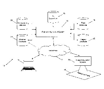
[0023] Turning now to the figures, FIG. 1 illustrates an example of a
configuration for a
precision agriculture platform 10 that includes a precision agriculture
prescription system 12
(the "system" 12) for generating prescriptions for spatial distribution of a
fertilizer product. In
this example, the system 12 is accessible via a computing device 14 over one
or more
networks 16, including via wired or wireless connections. As such, the system
12 can be
implemented as a cloud-based server or service that is accessible to various
users in
various locations. It can be appreciated that the implementation shown in FIG.
1 can also be
implemented in a closed system within an organization and the widely
distributed cloud
computing based model is used only for illustrative purposes.
[0024] The system 12 generates prescriptions for the spatial distribution
of particular
fertilizer products over a given one or more agriculture fields 18. The system
12 utilizes
imagery associated with the fields 18, which can be acquired using any
available imaging
technology such as remote sensing, using one or more image acquisition systems
20. The
image acquisition 20 shown in FIG. 1 can provide acquired images to the system
12 for
storage in an imagery database 22 or can upload such images directly to the
imagery
database 22 if granted suitable permissions and credentials. It can be
appreciated that
when images are acquired using other sources, not shown in FIG. 1, the
computing device
14 can also be used to send images to the system 12 or upload them directly in
a similar
manner.
[0025] The system 12 includes or otherwise has access to various other data
storage
elements as illustrated in FIG. 1. A weather database 24 is utilized to obtain
weather-related
data (e.g., weather forecast data), and a mineralization database 26 is used
to obtain soil
- 3 -
CA 03016216 2018-08-30
WO 2017/147682
PCT/CA2016/050323
mineral data to be used in generating a prescription for a particular field
18. The system 12
also utilizes field metadata 28 when other data related to the field 18 is
available, and stores
the generated prescriptions in a prescription (Rx) data store 30.
[0026] As indicated, the system 12 can be implemented in various
configurations and
utilizing various technologies, such as a cloud-based deployment. FIG. 2
illustrates an
example system architecture that can be used to implement the system 12. The
system 12
in this example architecture includes an application layer 40 and a platform
layer 42. The
application layer 40 is an abstraction layer that specifies and is responsible
for protocols and
methods used by the computing devices 14 in the communication network within
the
platform 10, to enable an precision agriculture application to be utilized by
a user on such a
computing device 14. The platform layer 42 is an abstraction layer that
specifies and is
responsible for the services utilized by the platform 10 to generate
prescriptions for particular
fields 18. For example, as shown in FIG. 2, the platform layer 42 includes or
otherwise
provides prescription services 44 for generating the prescriptions, reporting
services 46 for
generating prescription reports, and image services 48 for enabling the
application layer 40
to render images in a user interface as described in greater detail below, and
to perform
image processing that is used in prescription generation.
[0027] The system 12 also includes a cloud-based infrastructure component
50 for
enabling a cloud-based deployment, however a server-based deployment is also
possible.
[0028] As shown in FIG. 3, at a high level, the system 12 operates to get
images and
field data for a particular field 18 in a first stage 60, to generate a
precision agriculture
prescription in a second stage 62, and to display, export or otherwise provide
spatial outputs
63 (e.g., shapefiles) and/or reports 65 (which may optionally also include
spatial outputs 63)
at a third stage 64. This allows the data obtained in the first stage 60 to be
output in a
spatial output 63 such as a shapefile to illustrate the Rx map, or in a report
65 in the third
stage 64, that is based on a process executed in the second stage 62. The
second stage 62
can also include a sub-stage 66 or parallel process, that allows a user to
edit a prescription
based on an intermediate prescription as discussed below.
[0029] FIG. 4 illustrates further detail regarding the first stage 60. In
the first stage 60,
user authentication occurs at 70, which enables a user to enter credentials
(e.g., username
and password, biometric inputs, etc.) to access the system 12, the credentials
being
validated by the system 12 at the server or cloud side, and/or by an
application at a client
terminal being used to access the system 12. The authentication performed at
70 can be
configured to utilize various access control measures and permission levels to
provide
- 4 -
CA 03016216 2018-08-30
WO 2017/147682
PCT/CA2016/050323
different levels of access to different users, if desired by the particular
application or
organization utilizing the system 12.
[0030] An asynchronous image ingestion process is also executed at 74õ and
the
ingested imagery is formatted at 76 for storage in the imagery database 22.
The imagery is
obtained from imagery sources such as the image acquisition system 20. The
images are
assessed for cloud cover, image corrections when required are applied, geo-
corrections,
orthorectification, etc.
[0031] Once the user has been authenticated, an application is presented to
the user to
interact with using the computing device 14. The user enters field boundaries
and attributes
of the field at step 78, in any available format, for use in generating the
prescription. This
step can include an option to perform a batch import of multiple field
boundary data and/or
field definition shapefiles via an API. The attributes entered vary by the
product type, but
can include, for example, organic matter in the field 18, which is based on
geography, a
nitrogen (N) budget for the field 18, the crop to be planted, whether or not
irrigation is
used/available, drop years, prescription type, etc.
[0032] FIG. 5 illustrates a screen shot 100 of an example of a user
interface for entering
field boundaries, e.g., by selecting a Choose File button 102 to upload the
shapefiles. As
shown in FIG. 5, various search fields 104 can be provided to search for
growers, divisions,
locations, etc. In this example, grower details are provided as a search
result 106. An
image viewing pane 108 is also provided for viewing the shapefiles. FIG. 6
illustrates a
screen shot 150 of an example of a user interface for entering the input
parameters used to
generate a prescription. In this example a Nitrogen prescription type option
152 has been
selected, which displays the nitrogen inputs in a viewing pane 154. A series
of input options
156 are also provided to enable the inputs to be entered, for example, crop
type, % organic
matter, N budget, irrigation information, guaranteed analysis to convert a
rate from weight of
a particular component (N/K/P/S) to a rate of a specified product (having a
percentage of the
component of interest), override option, minimum nitrogen, maximum nitrogen,
solid
information related to the product type, and density.
[0033] In addition to inputting field boundaries and parameters in step 78,
the user can
also optionally manually draw a field boundary at step 80. This functionality
provides a
method for creating a field by drawing a polygon over a background image to
define the field
boundary. The product type and attributes mentioned above would also be
associated with
the manually drawn field. FIG. 7 illustrates a screen shot 200 of an example
of a user
interface for drawing and/or editing a field boundary 202. The field boundary
202 is
- 5 -
CA 03016216 2018-08-30
WO 2017/147682
PCT/CA2016/050323
displayed over a field image 204 and can be interacted with in order to edit
the boundary 202
to better correspond to the field being fertilized. Various administrative
options 206 are also
shown, which can include grower details, access to recent reports, and a list
of recently
created/accessed projects.
[0034] The field boundaries input at 78 and 80 are then validated at step
82. The
system 12 validates the correctness of the field boundaries and parameters
that have been
input to ensure that this data is not out of range or otherwise detectably
incorrect. The valid
data is then stored as field metadata 28. The system 12 then retrieves the
field metadata 28
and the associated images from the imagery database 22 at step 84. The
geographic
location of the field 18 influences the image dates and image selection. For
example, valid
crop data ranges vary for geographic regions in say, Canada or the northern
United States,
versus regions in the southern United States or Mexico, since growing seasons
can be
drastically different.
[0035] When the images are retrieved, they are reviewed to eliminate images
at 86.
For example, some images from the set of images associated with the field 18
may not be
useable due to cloud cover, snow cover, etc. A report of the selected images
can also be
generated during or upon completion of step 86. FIG. 8 illustrates a screen
shot 250 of an
example of a user interface for viewing and eliminating images. In the example
shown in
FIG. 8, a Landsat image 252 is displayed beside the calculated NDVI image 254.
[0036] FIG. 9 illustrates operations performed by the system 12 in
generating a
prescription in stage 62, which can be exported, printed, displayed or
otherwise provided as
a report in stage 64. The prescription generation process starts at step 300
and begins by
splitting the images for different processing, namely processing for soils and
processing for
those have a vegetative index associated therewith, such as the Normalized
Difference
Vegetation Index (NDVI) ¨ used herein as illustrative only. The image set is
split into a sub-
set of soil images at step 302 and a sub-set of NDVI images at 304 such that,
for the
collection of images available for that field, the system 12 determines which
images are
useful for soil calculations, and which are useful for NDVI calculations. For
example, in a
particular geographical region, the imagery used for soil content calculations
are within the
20 April to 7 May date range when the images would capture tilled soil. In the
same region,
imagery used for NDVI calculations may be within the 21 June to 1 September
range
representing when a crop is likely to be shown in the images (i.e. having
vegetation cover).
- 6 -
CA 03016216 2018-08-30
WO 2017/147682
PCT/CA2016/050323
[0037] The soil images in 302 are used to create a mineralization map at
306. The
mineralization map values are derived from the moisture determined from the
soil content
and a soil mineralization model, such as:
[0038] Ntotal = [Nfert Nmn],
[0039] wherein Ntert corresponds to the grower's fertilizer budget (for a
particular field),
which is typically a user input; and wherein Nmn is derived at a pixel level
using a soil
moisture map and a Net Soil Nitrogen Mineralization Model from the
mineralization database
26.
[0040] Calculating the Nmn for each pixel can be performed as follows:
[0041] a) Eliminate pixels that include field with clouds of, for example,
5% or greater
using band 1/thermal.
[0042] b) Eliminate images with pixel fill values which are images where no
data from
the satellite sensor is available.
[0043] c) Calculate median moisture ranking values per pixel.
[0044] d) Map to unit weight (e.g. pounds) of N from mineralization using
the Net Soil
Nitrogen Mineralization Model. Mapping using the Model can include the
following
parameters:
[0045] i) Organic matter for the field (user input or from a geography-
based database);
[0046] ii) Plant nitrogen uptake efficiency factor;
[0047] iii) Time;
[0048] iv) Plateau factor for the area (e.g., in the United States); and
[0049] v) Irrigated fields (user input).
[0050] The NDVI images obtained at step 304 are processed at step 308 to
weight the
image data. The image data is weighted using an algorithm that takes into
account historical
weather data and long range/seasonal forecasts obtained from the weather
database 24.
The weighting takes into account the number of images available for the given
year, and
analogous weather conditions, to provide the user with a weighted data set
from which to
calculate the weighted NDVI at step 310.
[0051] A distribution of N can now be determined at step 312, to generate a
baseline N-
budget from NDVI pixel content, and soil mineralization data. The NDVI
calculation can be
- 7 -
CA 03016216 2018-08-30
WO 2017/147682
PCT/CA2016/050323
performed as follows, using the field boundaries and the appropriate input
images within the
appropriate date range (e.g., June 21 to Sept 1):
[0052] a) Eliminate images with fill values.
[0053] b) Apply default weights to images based on day, year, number of
images in a
year, weather (Wx weighting based on precipitation ¨ If the upcoming year has
a higher than
normal expected precipitation, weight the images from years with above average
precipitation higher).
[0054] c) Calculate the weighted mean for each pixel based on NDVI values
from the
stack. The images can also be further processed to improve the aesthetics of
the output, if
so desired.
[0055] The NDVI values at each pixel can be clipped to eliminate high or
low values
based on a ranking in the field. For example, an upper limit of the 98th
percentile and a
lower limit of the 2' percentile can be used. The NDVI values are then
transformed into an
N interval depending on the N-budget or user override inputs.
[0056] An intermediate Rx map is then generated at step 314. This can be
done using
the transformed NDVI values by taking the total N needed in a unit of the
field and
subtracting the N from mineralization. That is, the N required for one unit of
the field is
computed by distributing the user input total N (i.e. the user-supplied N
budget available)
using field patterns observed by computing the NDVI values, and correcting for
N from
mineralization.
[0057] As shown in FIG. 9, the intermediate Rx map can be optionally edited
by the
user at step 316 to modify the Rx rates on the output from step 314. The
editing can
include, for example, entering checkstrips, field skirts, smoothing, and field
merge
operations. A checkstrip refers to a control sample area of the field where a
standard amount
of fertilizer is applied to provide a comparison sample against the rest of
the field. A field
skirt refers to an area of the field to which a user defined rate of
fertilizer is to be applied.
Smoothing refers to a setting to throttle/ramp up/down the application rate
that prevents the
application machinery from changing rates too quickly. Field merge operations
refer to
operations that combine multiple fields to generate a single prescription.
[0058] At step 318, a final Rx is generated by taking into account all of
the received
user inputs and the calculations described above. The output is provided in
rates/classes,
and different rates/classes can be provided as options for the output.
Different areas of the
field (classes) have different product rates prescribed, which makes the Rx a
variable rate
- 8 -
a
CA 03016216 2018-08-30
WO 2017/147682
PCT/CA2016/050323
Rx. Depending on how much fertilizer is to be put on a given area of the
field, a rate is
selected to achieve that amount, according to the equipment available and how
many rates it
utilizes. The total N is converted to a rate based on the product to be used
and the final Rx
map is grouped into a rate map with 100 classes. The per-class N rate is then
converted to
a product rate, for example, lbs/acre for solid fertilizer, or gallons/acre
for liquid fertilizer.
[0059] FIG. 10 illustrates a screen shot 450 of an example of a user
interface for
viewing and editing an Rx. A color-coded image 452 can be displayed to
illustrate the
various N classes/rates to be applied to the regions of the field according to
the variable rate
Rx. The N input attributes can also be assigned using an Assign button 454,
which enables
a user-driven editing of the Rx rates. It can be appreciated that the Rx can
be edited by
away of a general defined override/substitute of an Rx rate.
[0060] The final Rx is then stored in the Rx data store 30. Moreover, as
shown in FIG.
3, one or more reports can be provided at stage 64. The spatial outputs 63
and/or reports
65 can be formatted in any suitable manner and the shapefiles are generated
for the
generated Rx, which can be output as is, embedded in the reports 65 or
provided as data
that is reconstructed at a recipient location. Supporting data for the farmer,
the field, etc. can
also be included in such reports.
[0061] Turning now to FIGS. 11 to 13, sequence diagrams are shown for an
image
processing stage (FIG. 11), a prescription generation stage (FIG. 12), and a
prescription
viewing and editing stage (FIG. 13) that is implemented by the system 10 using
the example
architecture shown in FIG. 2.
[0062] The sequence diagrams illustrate various data communications, data
storage,
and other interactions between several components in the system. However,
these
communications and interactions are purely illustrative and can be performed
in other ways
without departing from the principles discussed herein. A user 500 in this
example interacts
with an app 502. The app 502 interacts with several system components, which
also are
able to interact with each other as discussed below. These system components
include field
services 504, a Rx manager 506, a request manager 508, a scene service 510, a
scene
recommender 512 and field metadata 514 (e.g. stored in the field metadata data
store 28).
[0063] In this example, the user 500 accesses the app 502 by opening an Rx
display to
initialize the app 502. This causes the app 502 to render a landing page which
is displayed
for the user 500 on their device. The user 500 may then manually draw the
fields, when
applicable. This issues an edit field command that is passed by the app 502 to
the field
- 9 -
CA 03016216 2018-08-30
WO 2017/147682
PCT/CA2016/050323
services 504 to enable the field services 504 to save the field selection and
synchronize the
field metadata 28, by issuing a sync fields command to the field metadata 514
entity.
[0064] The user 500 can also view the fields and search for particular
fields using the
app 502. This is done by sending a search command to the field services 504,
which
accesses the field metadata 514. The field meta data 514 returns field
information based on
the search and the field services 504 returns the appropriate fields to the
app 502. The app
502 renders the field information and displays this for the user 500.
[0065] Field selections and input parameters can be entered by the user
500, which
generates a request that is passed along by the app 502 to the request manager
508. The
request manager 508 determines an Rx status and logs the request. The user
inputs are
also validated by the request manager 508. It can be appreciated that as
illustrated in
FIG.11, if an error is encountered, the user 500 is notified by the request
manager 508. The
request is saved and a request ID is returned by the request manager 508 to
the user 500.
The user 500 is then able to view the progress of the request by updating the
application to
show the user what is being processed, which is shown in FIG. 12.
[0066] As illustrated in FIG. 12, the request manager 508 performs a get
scenes
operation to gather the appropriate images, and creates an Rx for the Rx
manager 506. The
Rx manager 506 returns an Rx ID for the particular Rx being generated. The Rx
manger
506 proceeds to calculate the NDVI, e.g., as described above. The Rx manager
506 also
gets soil mineral data, calculates soil moisture, calculates weather
weighting, gets Wx data,
generates an image report and generates the intermediate Rx. The request
manager 508
receives a complete notification (i.e. a notification that the process is
complete) and the Rx
manager 506 saves the Rx data in the Rx data store 30, and saves an image
report in the
imagery database 22.
[0067] As shown in FIG. 13, the user 500 selects an option to export a
report and the
Rx manager 506 communicates with the app 502 to display the report in order to
allow the
user 500 to view the Rx. The user 500 can also perform an image selection,
which initiates
a select command via the app 500, which is passed to the scene service 510.
The scene
service 510 saves the image selection and can repeat the operations in FIG. 12
if required,
to re-calculate the NDVI and the Rx. The Rx is then displayed for the user 500
via the app
502, and the user 500 can initiate an edit Rx operation. This causes an edited
Rx to be
displayed using the app 502. The user 500 is then able to export a report
and/or spatial
output corresponding to the edited Rx.
-10-
CA 03016216 2018-08-30
WO 2017/147682
PCT/CA2016/050323
[0068] For simplicity and clarity of illustration, where considered
appropriate, reference
numerals may be repeated among the figures to indicate corresponding or
analogous
elements. In addition, numerous specific details are set forth in order to
provide a thorough
understanding of the examples described herein. However, it will be understood
by those of
ordinary skill in the art that the examples described herein may be practiced
without these
specific details. In other instances, well-known methods, procedures and
components have
not been described in detail so as not to obscure the examples described
herein. Also, the
description is not to be considered as limiting the scope of the examples
described herein.
[0069] It will be appreciated that the examples and corresponding diagrams
used herein
are for illustrative purposes only. Different configurations and terminology
can be used
without departing from the principles expressed herein. For instance,
components and
modules can be added, deleted, modified, or arranged with differing
connections without
departing from these principles.
[0070] It will also be appreciated that any module or component exemplified
herein that
executes instructions may include or otherwise have access to computer
readable media
such as storage media, computer storage media, or data storage devices
(removable and/or
non-removable) such as, for example, magnetic disks, optical disks, or tape.
Computer
storage media may include volatile and non-volatile, removable and non-
removable media
implemented in any method or technology for storage of information, such as
computer
readable instructions, data structures, program modules, or other data.
Examples of
computer storage media include RAM, ROM, EEPROM, flash memory or other memory
technology, CD-ROM, digital versatile disks (DVD) or other optical storage,
magnetic
cassettes, magnetic tape, magnetic disk storage or other magnetic storage
devices, or any
other medium which can be used to store the desired information and which can
be
accessed by an application, module, or both. Any such computer storage media
may be part
of the precision agriculture platform 10, any component of or related to the
platform 10, etc.,
or accessible or connectable thereto. Any application or module herein
described may be
implemented using computer readable/executable instructions that may be stored
or
otherwise held by such computer readable media.
[0071] The steps or operations in the flow charts and diagrams described
herein are just
for example. There may be many variations to these steps or operations without
departing
from the principles discussed above. For instance, the steps may be performed
in a differing
order, or steps may be added, deleted, or modified.
-11-
'I
CA 03016216 2018-08-30
WO 2017/147682
PCT/CA2016/050323
[0072] Although the above principles have been described with reference to
certain
specific examples, various modifications thereof will be apparent to those
skilled in the art as
outlined in the appended claims.
-12-