Note : Les descriptions sont présentées dans la langue officielle dans laquelle elles ont été soumises.
CA 03028579 2018-12-19
WO 2018/002657 1 PCT/GB2017/051935
PORTABLE SURVEY METER AND METHOD
The present invention relates to a portable survey meter and a method for
measuring
radiation. More particularly, an embodiment of this invention relates to an
autonomous,
portable survey meter for collecting spatially registered radiation
measurements within a
region such as a nuclear facility.
When operating or decommissioning a facility containing radioactive material
it is
frequently necessary to understand the distribution of activity such that its
effects on the
environment and any persons entering that environment can be determined. It is
often the
case that the physical properties of such a facility need to be determined
also.
Conventional methods for determining this information typically involve bulky
equipment and rely on external references such as markers or fixed reference
points, at
various positions around the facility. This is often not permitted or
practical in a
potentially contaminated environment.
A radiological survey of a facility may be performed, with the positions and
measurements recorded. At a later point in time, it may be desirable to repeat
the survey
to determine how the distribution of radiation has changed. Radiological
measurements
are sensitive to the position at which they are taken. It is important
therefore that the
measurements made in the repeat survey are taken from the same positions as in
the
previous survey.
The present invention aims to alleviate this issue by providing a method to
collect both
spatial and radiological data in a manner that is independent of the facility
being surveyed
and can be deployed without reliance on any external input or reference.
Accordingly, one aspect of the present invention provides a portable survey
meter for
measuring radiation, the portable survey meter comprising:
a radiation detector configured to perform measurements of radiation;
a range sensor configured to measure range data of distances from the portable
survey meter to real world structures in at least two dimensions; and
a processing unit configured to align the measured range data with reference
range
data so as to determine an instantaneous position of the portable survey meter
in at least
.. two dimensions relative to the real world structures as a fixed frame of
reference,
whereby each measurement is performed at a known position.
CA 03028579 2018-12-19
WO 2018/002657 2 PCT/GB2017/051935
Another aspect of the present invention provides a method for measuring
radiation, the
method comprising:
performing measurements of radiation using a portable survey meter;
measuring range data of distances from the portable survey meter to real world
structures in at least two dimensions; and
aligning the measured range data with reference range data so as to determine
the
instantaneous position of the portable survey meter in at least two dimensions
relative to
the real world structures as a fixed frame of reference, whereby each
measurement is
performed at a known position.
.. Other, optional, aspects of the invention are defined in the dependent
claims.
Embodiments of the invention make it possible to record the spatial location
of
radiological measurements in a survey more accurately than traditional
radiation surveys
allow. Embodiments of the invention are expected to improve how accurately a
survey
can be repeated.
Embodiments of the invention will now be described, by way of example only,
with
reference to the accompanying drawings in which:
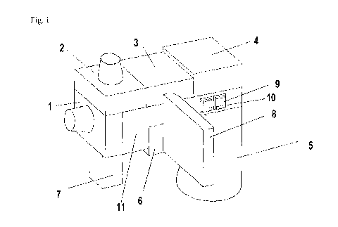
Figure 1 schematically depicts a portable survey meter according to an
embodiment of the
invention; and
Figure 2 schematically depicts the scanning plane of a L1DAR of a portable
survey meter
according to an embodiment of the invention.
Figure 1 schematically depicts a portable survey meter according to an
embodiment of the
invention. Optionally, the portable survey meter is for measuring radiation.
Optionally,
the portable survey meter is for checking for radioactive contamination.
Alternatively,
the portable survey meter may be used to carry out repeatable noise level
surveys (i.e.
measuring acoustic intensity) around a noisy industrial workplace.
The portable survey meter can be used in a method for collecting spatially
registered
radiological measurements. Optionally, the portable survey meter comprises a
radiation
detector 7. Alternatively, the portable survey meter may comprise a noise
detector
configured to perform noise measurements of acoustic intensity.
CA 03028579 2018-12-19
WO 2018/002657 3 PCT/GB2017/051935
Optionally, the radiation detector 7 is configured to perform measurements
(e.g.
radiological measurements) of ionising radiation. The radiation detector 7 is
a means of
measuring the level of ionising radiation. Additionally or alternatively, the
radiation
detector 7 is configured to perform measurements of non-ionising radiation.
Optionally, the portable survey meter comprises a range sensor 1, 2. The range
sensor 1,
2 is configured to measure range data of distances from the portable survey
meter to real
world structures in at least two dimensions. The range data is interpreted by
an algorithm
to determine an instantaneous position of the portable survey meter in at
least two
dimensions relative to the real world structures as a fixed frame of
reference. The range
sensor combines with software running the algorithm to determine the position
of the
portable survey meter relative to the real world structures. Accordingly, each
radiological
measurement is performed at a known position.
The range sensor 1, 2 combined with the software is a means of determining the
instantaneous position of the portable survey meter (which may also be called
a detector)
in a least two dimensions relative to real world structures surrounding the
portable survey
meter.
Each range sensor 1, 2 is configured to measure the distance (i.e. range) from
the portable
survey meter to a real world object, such as a wall. The range sensor 1, 2 is
configured to
measure time-varying range data about how far the portable survey meter is
from real
world structures in different directions. In particular, the first range
sensor 1 is
configured to measure the range to real world objects in the XY plane. The
range data is
then used to determine the position of the portable survey meter to the real
world objects.
This can be done by aligning the range data to known information about the
real world
structures.
For example, the range data may provide information about the distance from
the portable
survey meter to a series of points of a room. The position of the portable
survey meter
can then be determined by aligning the range data to a map of the room. The
map of the
room is an example of known information about the layout of the real world
structures.
Hence, the measured range data is interpreted to provide positional
information relative to
the real world structures. This interpretation is performed by software that
runs an
algorithm configured to deduce the motion of the portable survey meter by
aligning the
range data with reference range data (e.g. a map).
CA 03028579 2018-12-19
WO 2018/002657 4 PCT/GB2017/051935
By aligning the measured range data to reference range data (e.g. a map of the
real world
structures), the position of the portable survey meter can be determined
relative to the real
world structures as the fixed frame of reference. This is different from other
means of
detecting position such as GPS, radio beacon methods and QR code readers. GPS,
radio
beacon methods and QR code readers rely on measuring the distance to
satellites, beacons
or QR codes that have a known position in a coordinate system. The position of
the
reader can be determined by measuring the distance to multiple satellites,
beacons or QR
codes and solving equations to determine the position of the reader within
that coordinate
system. These methods do not involve aligning the measured distances to the
satellites,
beacons or QR codes to reference range data.
The invention does not require any real world objects to be installed for the
purpose of
position determination. In particular, the invention does not require any
satellite, beacon
or QR code. The real world structures are not satellites, beacons or QR codes.
Instead,
the range sensor 1, 2 measures the range to objects that just happened to be
there. The
position of the objects in another coordinate system is not required to be
known. The
measured range data is aligned with the reference range data so that the real
world
structures themselves become the fixed frame of reference.
Alignment of range data may be achieved by any algorithm which is capable of
calculating a transform between the current range data and one or more
examples of
reference range data. It is preferable in the present application that such
algorithms be
designed to keep computation demands to a minimum in order that the physical
space and
power requirements of the radiation measurement device can be kept low. An
algorithm
which is particularly suitable for aligning horizontal-plane range data is
described:
1) Each example of horizontal plane range data (either current or
reference) is
'rotational normalised' based on intrinsic properties of the data rather than
by
comparing with reference data. This reduces the dimension of the alignment
problem
space from three dimensions (X,Y,Theta) to two dimensions (X,Y). A good
measure
of intrinsic orientation in man-made environments is to apply a candidate
rotation,
calculate a one-dimensional histogram, H, of X values and Y values of the
range data
and then to calculate the entropy of this histogram (approximated by the sum
of H
multiplied by the natural logarithm of H). The intrinsic orientation is that
which
minimises the entropy score. Note that it is only necessary to search over a
90 degree
CA 03028579 2018-12-19
WO 2018/002657 5 PCT/GB2017/051935
range of orientation as this measure of orientation is invariant to rotations
of 90
degrees.
2) The two dimensional search can then be reduced to two one dimensional
searches by
comparing the X and Y histograms of the current and reference range data. To
align
the X axes of the current data with the reference scan, it is sufficient to
search for the
maximum of F(Rx(X),Cx(X+Xo)) with respect to Xo, where F is a similarity
measure
function whose output is maximised when the histograms are aligned, Rx(X) is
the
histogram of X values of the reference data, Cx(X) is a histogram of the
current data
and Xo is a candidate value for the X offset between reference data and
current data. F
can be any measure of similarity between histograms or probability
distributions; the
simplest method being the dot product of the two input histograms. Because
this
method is computationally inexpensive, it is generally possible to maximise
F(Rx(i),Cx(i+Xo)) by exhaustive search. Note that, because of the symmetry of
the
orientation normalisation step with respect to 90 degree rotations, it is not
sufficient to
compare Cx(i) with Rx(i) and Cy(i) with Ry(i) because there may be an
orientation
shift of a multiple of 90 degree between reference and current data. This can
be
resolved by aligning all four possible orientations independently and taking
the
orientation with the highest alignment score as the true orientation. The four
alignments can be implemented by comparing: Cx(i) with Rx(i) and Cy(i) with
Ry(i); Cx(i) with Ry(i) and Cy(i) with Rx(-i); Cx(i) with Rx(-i) and Cy(i)
with Ry(-i);
and Cx(i) with Ry(-i) and Cy(i) with Rx(i).
The algorithm related above will also work for vertical lidar data if step 2
is restricted to a
the vertical dimension only. As described, the algorithm is limited to the
case where the
current data overlaps significantly with the reference data. In applications
where this is
not the case, the algorithm can be extended by introducing the concept of a
key-frame.
When the current range data is found to be offset from the reference data by
some pre-
determined distance threshold, or when the similarity score drops beneath a
pre-
determined threshold, the current frame is nominated as a 'key-frame'.
Subsequent range
data will be registered to the most recent fey-frame rather than the original
reference data.
The alignment between the original reference data and the current data can
then be
deduced by combining the transform between the current data and the current
key-frame
with the transform between the current key-frame and the reference frame
(which may
itself depend on the transforms of other intermediate key-frames).
CA 03028579 2018-12-19
WO 2018/002657 6 PCT/GB2017/051935
Optionally, the portable survey meter comprises a means of continuously
recording
spatial data such that a 3D model can be generated as the portable survey
meter is moved
around the area.
The measurement of radiological and geometrical data may be achieved using a
combination of sensors (e.g. the radiation detector 7 and the range sensor 1,
2). The
sensors that provide the geometrical data may be configured to determine the
location and
orientation of the portable survey meter in six degrees of freedom relative to
real world
structures. However, this is not necessarily the case. The sensors that
provide the
geometrical data may be configured to determine the location of the portable
survey meter
.. in two degrees of freedom (e.g. in a horizontal plane), three degrees of
freedom (e.g. in a
horizontal plane and a vertical plane), four degrees of freedom (e.g. in a
horizontal plane
and a vertical plane and the yaw of the portable survey meter) or five degrees
of freedom
(e.g. in a horizontal plane and a vertical plane and the pitch and yaw of the
portable
survey meter).
As depicted in Figure 1, the portable survey meter optionally comprises two
range sensors
1, 2. However, this is not necessarily the case. In alternative embodiments
the portable
survey meter comprises only one range sensor 1, or more than two range
sensors.
Optionally, the first range sensor 1 is configured to measure range data of
distances from
the portable survey meter to real world structures in the horizontal (XY)
plane.
Optionally, the range sensor 1, 2 is configured to measure the range data
using Light
Detection and Ranging (L1DAR), Sound Navigation and Ranging (SONAR) or Radio
Detection and Ranging (RADAR). The first range sensor 1 could be a L1DAR
instrument, a SONAR instrument or a RADAR instrument. The first range sensor 1
is
capable of measuring the distance from the portable survey meter to real world
structures,
surrounding the portable survey meter.
When the first range sensor 1 is a L1DAR instrument, the L1DAR instrument is
configured to rotate around the Z axis making an angle theta to the X axis,
shown in
Figure 2. The first range sensor 1 is configured to scan the XY plane, making
a series of
measurements of the distance at angle theta to the nearest surface based on
the time of
flight of laser pulses emitted by the L1DAR instrument and reflected off the
surface.
Change in position of the portable survey meter over time can be measured by
calculating
the translation and rotation that best aligns the current range data with the
previous (e.g.
CA 03028579 2018-12-19
WO 2018/002657 7 PCT/GB2017/051935
initial) range data. The reference range data to which measured rage data is
aligned may
be the initial range data measured when a survey is started. Hence, it is not
necessary for
a map of the region to be surveyed to be known. Even without such a map it is
possible
for a model of the region to be built up during the survey.
The survey meter of the present invention is designed to be portable. The
portable survey
meter could be hand held. As a result, there is the possibility that the
portable survey
meter does not remain fixed in the XY plane throughout the survey, and/or the
portable
survey meter may move vertically. Furthermore, the portable survey meter may
be tilted,
giving a false impression of the surrounding world. Optionally, to counteract
this, the
output from the first range sensor 1 (which may also be called a horizontal
position
measurement device) is corrected for tilt as described below.
Optionally, the portable survey meter comprises an orientation detector 3. The
orientation detector 3 is configured to determine at least one of an
instantaneous yaw, an
instantaneous roll and an instantaneous pitch of the portable survey meter
relative to the
real world structures. The orientation detector 3 is configured to measure the
tilt of the
portable survey meter such that a correction factor can be applied to the XY
data to
ensure it represents a more accurately horizontal plane. Optionally, the
orientation
detector is an Inertial Measurement Unit (IMU) configured to measure at least
six degrees
of freedom. Optionally, the portable survey meter comprises a magnetometer for
improved orientation accuracy.
Optionally, the portable survey meter comprises a mechanical stabiliser
device.
Optionally, the mechanical stabiliser device is fitted to the rest of the
portable survey
meter so as to prevent or reduce any tilt.
Optionally, the portable survey meter comprises a positional feedback
provider. The
positional feedback provider is configured to output to a user information to
help the user
move the portable survey meter to a target position and/or orientation
relative to the real
world structures. Optionally, the positional feedback provider is configured
to output to
the user information to help the user change at least one of the yaw, the roll
and the pitch
of the portable survey meter to a target yaw, a target roll and a target
pitch, respectively,
relative to the real world structures. Optionally, the positional feedback
provider is
configured to provide feedback to allow the user to manually correct for any
tilt.
CA 03028579 2018-12-19
WO 2018/002657 8 PCT/GB2017/051935
If an IMU is used as the orientation detector 3, the instantaneous pitch, roll
and yaw of the
portable survey meter can be measured such that, when combined with the data
measured
by the first range sensor 1, five of the six degrees of freedom are known
(X,Y, pitch, roll
and yaw).
In order to determine the position of the detector in the Z direction, or
height above the
ground, another sensor, i.e. the second range sensor 2, is required.
Optionally, a second
LlDAR, SONAR or RADAR detector could be used. Optionally, the portable survey
meter comprises a processing unit 4 (also called a main processing unit).
Utilising the
assumption that the ground is flat and once the angle of the portable survey
meter (away
from vertical) is known, trigonometry can be used to calculate the height of
the portable
survey meter. Optionally, the processing unit 4 is configured to calculate the
height of the
portable survey meter based on the angle of the portable survey meter as
measured by the
orientation detector 3. Optionally, the second range sensor 2 is rigidly
attached to the first
range sensor 1. The data output by the range sensor 1, 2 can be used to build
a 3D model.
When all six degrees of freedom are known the position of the portable survey
meter
within the 3D model can be accurately plotted by the processing unit 4.
Optionally, the
processing unit 4 is configured to receive range data from the first range
sensor 1 and, if
the second range sensor 2 is provided, also from the second range sensor 2.
The
processing unit 4 is configured to compare the range data with previous range
data
(possibly the initial range data). The processing unit 4 is configured to
calculate the
translation and rotation that best aligns the current range data with the
previous (e.g.
initial) range data so as to measure a change in position and/or orientation
of the portable
survey meter over time. Alternatively, the processes of comparing the range
data and
calculating the translation and rotation to measure the change in position may
be
performed by a processor that is positioned remotely from the portable survey
meter.
Additionally or alternatively, the portable survey meter comprises a height
detector
configured to determine an instantaneous height of the portable survey meter
above a
floor. Optionally, the height detector is a sensor that directly measures a
property that
changes predictably with changes of position in the Z direction. For example,
optionally
the portable survey meter comprises a barometric pressure sensor.
Radiological data is collected using a suitable radiation detector 7, for
example a Geiger-
Muller tube, a total count detector or a scintillator. The types of radiation
that are
CA 03028579 2018-12-19
WO 2018/002657 9 PCT/GB2017/051935
measured may not be limited to gamma rays but may be any type or types of
ionising or
non-ionising radiation. The device collects a series of measurements of the
radiation field
at registered positions, determined by the range sensor 1, 2 and software
described above.
Optionally the radiation detector 7 is rigidly attached the range sensor 1, 2.
The output from each of the range sensor 1, 2, the software and the radiation
detector 7
provides a two or three dimensional model of the facility, a series of
radiation
measurements and a set of coordinates (optionally corrected for the
orientation of the
portable survey meter) that describe the location of each radiation
measurement within
the model. Optionally, the portable survey meter comprises a local memory. The
local
.. memory is configured to record the position of the portable survey meter at
which each
radiological measurement was performed in association with the radiological
measurement. This information is stored on-board the portable survey meter on
a suitable
storage device such that it can be retrieved at a later time for further
processing or
manipulation.
Optionally, the portable survey meter comprises a data uploader. The data
uploader is
configured to send information indicating each radiological measurement and
the position
of the portable survey meter at which the radiological measurement was
performed to an
external memory.
The optional final stage in the process is to utilise the information gathered
by the
portable survey meter described above to predict the distribution of
radioactive sources
within the facility. To do this the method outlined in European patent 2074442
could be
used.
The portable survey meter illustrated in Figure 1 is an apparatus that
comprises two
LIDAR sensors mounted such that one scans the XZ vertical plane while the
other scans
the XY horizontal plane, as the range sensors 1, 2. It is not essential to
have two range
sensors 1, 2. In an alternative embodiment the portable survey meter comprises
only one
range sensor 1, such that the position of the portable survey meter can be
determined in
two dimension (i.e. in the XY plane). Optionally, the portable survey meter
comprises a
height detector configured to measure the height of the portable survey meter.
In these
embodiments, LIDAR data is used to improve the accuracy and stability of roll
correction
as follows: during each scan a histogram is made of the vectors between
successive
LIDAR echoes. Peaks appear in the histogram separated by 90 degrees,
representing the
CA 03028579 2018-12-19
WO 2018/002657 10 PCT/GB2017/051935
floor / ceiling and the walls as real world structures. Assuming that the
structure of the
surrounding region does not fundamentally change between scans, the histogram
obtained
from successive scans will be similar but offset by any change in the roll
angle of the unit.
This therefore provides a means of detecting and correcting for changes in
roll angle
which is used to refine the data obtained from the IMU as the orientation
detector 3.
In other embodiments SONAR, RADAR or other forms of scanning or staring
distance
measurement sensors may be used. A Geiger-Muller tube is used as the radiation
detector
7 (also called a radiometric sensor) in this embodiment. However in other
embodiments
the radiation detector 7 may be, for example, an uncollimated total-counts
gamma
radiation sensor, an un-collimated total absorbed dose radiation sensor or any
other type
of radiation detector as required by the application. Optionally, the
radiation detector 7 is
configured to perform a radiological measurement by detecting an amount of
radiation
received from any direction over a predetermined time period. The radiation
detected by
the radiation detector 7 is not limited to gamma radiation but may be any type
or types of
ionising or non-ionising radiation.
Optionally, the radiation detector 7, the range sensors 1, 2 and the
orientation detector 3
are mounted together. Optionally, the portable survey meter comprises a frame
11. The
radiation detector 7, the range sensors 1, 2 and the orientation detector 3
may be mounted
on the frame 11, so that they are fixed relative to each other. The frame 11
can be hand-
held. The frame 11 may be mounted on a remote deployment platform, for example
a
long pole or a remotely operated vehicle, such as a remotely controllable
platform with
robotic arm, or a quadcopter. This may be particularly advantageous if
deployment is
required in a region where expected radiation levels are too high to permit
human entry.
As mentioned above, optionally the portable survey meter comprises a
positional
feedback provider. Optionally, the portable survey meter comprises a display
8, which
may form part of the positional feedback provider. The display 8 may be
mounted to the
frame 11 so that the display 8 can display instructions directing the user to
the next target
position (i.e. measurement point).
Optionally, the positional feedback provider is configured to output to the
user
information to help the user change the height of the portable survey meter to
a target
height relative to the floor.
CA 03028579 2018-12-19
WO 2018/002657 11 PCT/GB2017/051935
Optionally, the radiation detector 7 is configured to automatically perform a
radiological
measurement when the difference between the instantaneous position of the
portable
survey meter and a target position is less than a threshold positional
difference. In other
words, the measurement is triggered automatically once the portable survey
meter is
sufficiently close to the intended location (i.e. the target position).
However, it is not
necessary for the measurement to be performed automatically.
Optionally, the portable survey meter comprises an input device configured to
allow a
user to instruct the radiation detector 7 to perform a radiological
measurement at the
current position of the portable survey meter. In the embodiment depicted in
Figure 1, the
input device is a trigger 10. The trigger 10 is provided so that once at the
correct location
the user can provide an input causing the portable survey meter to take a
spatially tagged
radiation measurement. Alternatively, the measurement could be triggered by
other
means of user input.
Optionally, the radiation detector 7 is configured to perform a radiological
measurement
simultaneously with the range sensor 1, 2 combined with the software
determining the
instantaneous position of the portable survey meter. Accordingly, each
radiation
measurement is spatially tagged. Each radiation measurement is stored together
with
information regarding the position and optionally orientation of the portable
survey meter.
Optionally, the portable survey meter comprises a handle 5. The handle makes
it easier
for a user to hold the portable survey meter steadily while moving around a
facility to
take a survey.
Optionally, the portable survey meter comprises a battery 6. The battery 6 is
provided as
a power source for the portable survey meter. Optionally, the portable survey
meter
comprises a switch 9. The switch 9 is a power switch for the portable survey
meter.
The portable survey meter is taken to the facility to be modelled and is
switched on using
switch 9. On completion of the power-up sequence, surveying may be started
automatically. The portable survey meter starts to record positional data as
follows: the
range sensors 1, 2 record distances to real-world structures within their
respective
measurement planes and the orientation detector 3 records relative position
and
orientation continuously. This data is stored on a storage medium within the
processing
unit 4 and is also processed in real time using an algorithm to build up a 2D
model of the
CA 03028579 2018-12-19
WO 2018/002657 12 PCT/GB2017/051935
surveyed region. Optionally, the processing unit 4 comprises the software that
is
configured to align the measured range data with reference range data so as to
determine
the instantaneous position of the portable survey meter in at least two
dimensions relative
to the real world structures as a fixed frame of reference.
.. The Manhattan world assumption, that structures appear little different
from observation
points closely spaced along the Z axis, is used in processing. This model is
held in the
processing unit 4. The processing unit 4 is also loaded up with a series of
target positions
(i.e. a set of survey locations) relative to the facility structure.
Optionally, the portable survey meter comprises a target position setting
unit, which may
.. be embodied in the processing unit 4. Once the 2D model has built up
sufficiently for the
processing unit 4 to locate itself within the facility structure, the
direction and distance to
the next survey location is indicated on the display 8. Optionally, the target
position
setting unit is configured to set a new target position from among the series
of target
positions after the radiation detector 7 has performed the radiological
measurement at the
target position. Optionally, the target position setting unit is configured to
set a new
target position from among the series of target positions upon instruction
from a user to
skip the target position.
In other embodiments the order of measurements might be unimportant and the
portable
survey meter might direct the user to the closest measurement point rather
than the next in
sequence. Once the portable survey meter is at the desired survey point, a
measurement is
made automatically or on demand based on the user pressing the trigger 10.
Embodiments
may feature a software interlock to prevent the measurement being taken when
the unit is
too far from the survey point, or they may eliminate the user input in favour
of having the
measurement triggered automatically when the sensor is within an acceptable
distance of
the required survey location.
Optionally, the radiation detector 7 is configured to automatically perform a
radiological
measurement when the difference between the instantaneous position of the
portable
survey meter and a target position is less than a threshold positional
difference and the
difference between the at least one of the instantaneous yaw, the
instantaneous roll and
the instantaneous pitch of the portable survey meter and a target yaw, a
target roll and a
target pitch, respectively, is less than a threshold yaw difference, a
threshold roll
difference and a threshold pitch difference, respectively.
CA 03028579 2018-12-19
WO 2018/002657 13 PCT/GB2017/051935
Optionally, the radiation detector 7 is configured to automatically perform a
radiological
measurement when the difference between the instantaneous position of the
portable
survey meter and a target position is less than a threshold positional
difference and the
difference between the instantaneous height of the portable survey meter and a
target
height is less than a threshold height difference.
Embodiments may provide visual, audio or other sensory feedback to the
operator to
indicate the progress and completion of the measurement. When each radiation
measurement is completed it is tagged with a location, relative to the 2D
region model,
calculated from the LIDAR sensors and IMU, and stored in the storage attached
to the
.. processing unit 4.
The facility could be a single room, multiple rooms in a building, the
exterior surface of
building walls or indeed any three dimensional environment containing unknown
distribution of radioactive material in which it is possible to determine
location and
orientation using the inbuilt geometric sensors, i.e. the range sensors 1, 2
and the
orientation detector 3. The general term "region" is used for any such
facility or space for
which it is intended to determine the distribution of radioactive material.
The number of observations required will be determined by the operator's
survey
requirements but the automated spatial registration and user feedback provided
by the unit
facilitate the recording of a larger number of survey points in the same time
when
.. compared to existing manual techniques.
After data collection is complete the data is transferred from the apparatus
to a separate
computer system for analysis. The data as collected provides dose information
at a
number of locations within the surveyed region. This data is similar in nature
to that
obtained by a manually conducted radiation survey in which the location of
each
measurement is simply marked approximately on a floor plan of the facility,
but by using
this embodiment of the invention the spatial location of each measurement is
recorded
much more accurately than traditional radiation surveys allow.
List of reference numerals used in Figure 1:
1. first range sensor
2. second range sensor
CA 03028579 2018-12-19
WO 2018/002657 14
PCT/GB2017/051935
3. orientation detector
4. processing unit
5. handle
6. battery
7. radiation detector
8. display
9. switch
10. trigger
11. frame