Note : Les descriptions sont présentées dans la langue officielle dans laquelle elles ont été soumises.
H0062383-CA
METHOD AND SYSTEM FOR GENERATING A GRID MAP THAT SHOWS AIR
TRAFFIC INTENSITY
TECHNICAL FIELD
[0001] The present invention generally relates to aircraft and air traffic
operations, and
more particularly relates to generating a grid map for a defined airspace
volume that shows
aircraft traffic intensity.
BACKGROUND
[0002] As aircraft traffic density increases, flight planning and
trajectory optimization
for individual flights become more important. This is especially true with
respect to
constraints such as weather conditions, published airspace restrictions, etc.
which can have a
major impact on flight planning. Also, maintaining separation between aircraft
is essential.
However, the complexity associated with reliable assurance of such separation
increases
with traffic density. Proper optimization of flight planning will seek to
avoid fluctuations in
air traffic controller (ATC) workload. Hence, there is a need for generation
of a grid map
that represents predicted aircraft traffic density as it evolves over time.
BRIEF SUMMARY
[0003] This summary is provided to describe select concepts in a simplified
form that
are further described in the Detailed Description. This summary is not
intended to identify
key or essential features of the claimed subject matter, nor is it intended to
be used as an aid
in determining the scope of the claimed subject matter.
[0004] A method is provided for generating a grid map that shows aircraft
traffic
intensity. The method comprises: collecting position data and an associated
flight plan for
each aircraft within a defined airspace volume; modeling the movement for each
aircraft
based on the latest observed position and the flight plan of the aircraft;
dividing the defined
airspace volume into a grid pattern comprising a plurality of cubes with
defined spatial and
1
CA 3034428 2019-02-21
H0062383-CA
time resolution periods; assigning each aircraft to a cube based on the
aircraft's modeled
movement over future time resolution periods; calculating a value for the
number of
assigned aircraft to each cube of the grid over future time resolution
periods; calculating the
ratio of the value of the number of assigned aircraft to a pre-determined air
traffic control
(ATC) capacity for the defined airspace volume over future time resolution
periods;
determining the suitability of the defined airspace volume for planned
aircraft traffic based
on the calculated ratios of the number of assigned aircraft to ATC capacity
for each cube
within the defined airspace volume; and displaying a traffic intensity map
that reflects the
suitability of the defined airspace volume for planned aircraft traffic.
[0005] A system is provided for generating a grid map that shows aircraft
traffic
intensity. The system comprises: a data source that provides position
information for each
aircraft within a defined airspace volume; a data source that provides a
flight plan for each
aircraft within the defined airspace volume; a data source that provides
capacity limitations
for the defined airspace volume; and a server-based processor that collects
the position
information, the flight plans and the capacity limitations from each
respective data source,
where the processor, models the movement for each aircraft based on the latest
observed
position and the flight plan of the aircraft, divides the defined airspace
volume into a grid
pattern comprising a plurality of cubes with defined spatial and time
resolution periods,
assigns each aircraft within the defined airspace volume to a cube based on
the aircraft's
modeled movement over future time resolution periods, calculates a value for
the number of
assigned aircraft to each cube of the grid over future time resolution
periods, calculates the
ratio of the value of the number of assigned aircraft to the capacity
limitations for each cube
over future time resolution periods, determines the suitability of the defined
airspace volume
for planned aircraft traffic based on the calculated ratios, and generates a
traffic intensity
map that reflects the suitability of the defined airspace volume for planned
aircraft traffic;
and a retrievable electronic database that stores the ratio of the value of
the number of
assigned aircraft to the capacity limitations for later historical analysis of
aircraft traffic
patterns.
[0006] Furthermore, other desirable features and characteristics of the
method and
system will become apparent from the subsequent detailed description and the
appended
claims, taken in conjunction with the accompanying drawings and the preceding
background.
2
CA 3034428 2019-02-21
I-10062383-CA
BRIEF DESCRIPTION OF THE DRAWINGS
[0007] The present invention will hereinafter be described in conjunction
with the
following drawing figures, wherein like numerals denote like elements, and
wherein:
[0008] FIG. 1 shows a diagram of a grid pattern for defined airspace volume
in
accordance with one embodiment;
[0009] FIG.2 shows a flowchart for a method for generating a grid map that
shows air
traffic intensity in accordance with one embodiment; and
[0010] FIG.3 shows a block diagram of a system for generating a grid map
that shows
aircraft traffic intensity in accordance with one embodiment.
DETAILED DESCRIPTION
[0011] The following detailed description is merely exemplary in nature and
is not
intended to limit the invention or the application and uses of the invention.
As used herein,
the word "exemplary" means "serving as an example, instance, or illustration."
Thus, any
embodiment described herein as "exemplary" is not necessarily to be construed
as preferred
or advantageous over other embodiments. All of the embodiments described
herein are
exemplary embodiments provided to enable persons skilled in the art to make or
use the
invention and not to limit the scope of the invention which is defined by the
claims.
Furthermore, there is no intention to be bound by any expressed or implied
theory presented
in the preceding technical field, background, brief summary, or the following
detailed
description.
[0012] A method and system for generating a grid map that represents
aircraft traffic
density has been developed. Some embodiments include collecting position data
and an
associated flight plan for each aircraft within a defined airspace volume. The
movement of
each aircraft is modeled based on its latest observed position in combination
with the flight
plan of the aircraft to determine the aircraft's intended trajectory. The
defined airspace
volume is divided into a grid pattern that includes a plurality of "cubes"
that have defined
3
CA 3034428 2019-02-21
H0062383 -CA
spatial resolution as well as defined time resolution periods. Each aircraft
is assigned to a
specific cube based on its modeled movement over future time periods. In this
manner, it is
possible to calculate a value for the number of assigned aircraft to each cube
of the grid over
future time resolution periods. It is possible to further calculate a ratio of
the number of
aircraft present in a specific cube to a predetermined regulatory traffic
density capacity for
future time periods. This allows the suitability of the defined airspace
volume to be
determined for aircraft traffic patterns for each cube. This information may
then be
displayed on a traffic intensity map that reflects the suitability of the air
traffic density.
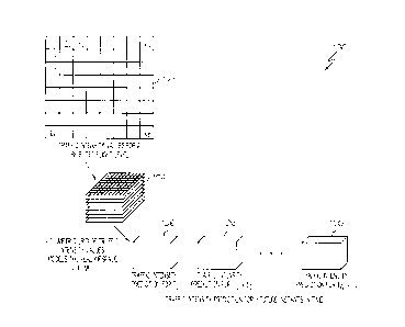
[0013] Turning now to FIG. 1, a diagram 100 is shown of a grid pattern for
defined
airspace volume in accordance with one embodiment. In this example, a square-
shaped
airspace volume is selected to be divided up into cubes. First, an overhead
view 102 of the
airspace volume for a single flight level is shown that is divided up into an
8 x 8 grid. It
should be understood that a real life application will have a significantly
higher number of
squares in a grid. The 8 x 8 grid shown here is a simplified example for ease
of reference.
Each cube in the grid is identified by a specific identification number (I
x,y). In this
example, each cube is identified using a Cartesian coordinate system.
Specifically, the x
variable represents the column number while the y variable represents the row
number.
Consequently, the cube in the upper left-hand corner will have a coordinate's
of "I 1, 1", the
cube directly below it will have a coordinate of "11,2", and the cube directly
to its right will
have a coordinate of "I 2, 1". Next, an additional eight layers of the
airspace volume are
added to create a three-dimensional grid pattern of cubes 104. As with the
example of the
grid pattern, a real life application may utilize more flight levels based on
traffic analysis.
An additional variable (z) is added to cube's coordinates to indicate the
appropriate level of
the cube (I , y, z). In this manner, each cube is readily identifiable in
three dimensional
space. Finally, each cube is given an initial resolution period (To) 106 to
indicate the status
of the traffic intensity within the cube at a specific time. Additional values
in time are
indicated by adding traffic intensity data predicted for future time periods
to the initial value
(To + Ti). Subsequent predicted traffic intensity values for "n" number of
time intervals for
future time periods may be added to this value as desired (To+ Tn).
[0014] In other embodiments, alternative methods may be used to identify
each cube
and time period. For example, a standard numerical designation of a cube may
be used that
numbers each cube sequentially (e.g., 1, 2, 3 ....). The spatial size of the
cubes may also
vary and the sizes are adjustable. These adjustments may be made as required
based on the
4
CA 3034428 2019-02-21
H0062383-CA
performance parameters of the aircraft as well as the resolution requirements
to monitor the
air traffic intensity. In some embodiments, the spatial resolution value of
the entire defined
airspace volume may be between 10-50 nautical miles (NM). In a similar manner
as the
spatial resolution, the time resolution may also be adjusted based on
performance
parameters and precision requirements to monitor air traffic intensity. In
some
embodiments, the time resolution periods may be between 1-30 minutes between
calculations of traffic intensity.
[0015] Turning now to FIG. 2, a flowchart 200 is shown for a method for
generating a
grid map that shows air traffic intensity in accordance with one embodiment.
First, both
position data and an associated flight plan for each aircraft within a defined
airspace volume
is collected 202. The aircraft position data and the associated flight plan
may be available
through various government infrastructures such as the Federal Aviation
Administration's
System Wide Information Management (FAA SWIM) system, the European Union's
System Wide Information Management (EU SWIM) system, or various private
companies
such as Open-Sky Network, Flight Radar 24, Flight Aware, etc. These systems
maintain
databases that are sources of real time aircraft surveillance data which are
often
complemented with flight plan data for each aircraft. The flight plan and the
latest observed
position of the aircraft are used to model a movement trajectory 204 for each
aircraft within
the airspace volume. In alternative embodiments, extrapolation of an
aircraft's current
trajectory may be used to estimate future positions if a flight plan for the
aircraft is not
available from the data source or because a flight plan was not filed.
[0016] The defined airspace volume is then divided into a grid pattern
comprising a
plurality of cubes with each cube having a defined spatial and time resolution
period 206.
Each aircraft is assigned to a specific cube based on the aircraft's modeled
movement over
future time resolution periods 208. A value is calculated that reflects the
number of assigned
aircraft for each cube of the grid over future time resolution periods 210. A
predetermined
air traffic control (ATC) capacity for the airspace volume is retrieved from
an outside data
source 214 and used to calculate a ratio of the number of aircraft assigned
for each cube
with respect to the ATC capacity for the airspace volume over future time
periods. In some
embodiments, the ATC capacity may be continuously updated based on changing
conditions
such as weather, current traffic, or other conditions.
CA 3034428 2019-02-21
H0062383-CA
[0017] The suitability of the defined airspace volume for the planned
aircraft traffic is
determined based on the calculated ratios of the number of assigned aircraft
to the ATC
capacity within the defined airspace volume 214. A traffic intensity map is
generated and
displayed on a visual display device for the aircrew of the aircraft. In some
alternative
embodiments, the traffic intensity map reflects the suitability of the defined
airspace volume
for the planned aircraft traffic for each cube 216. In some embodiments, the
traffic intensity
map may depict the cubes of the gird in a three dimensional (3D) visual format
104 as
shown previously in FIG. 1. The 3D format shows not only the status of each
individual
cube but also the status on other cubes in the area and their proximate
relationship to each
other. This allows a quick visual depiction of areas of air traffic congestion
and the location
of the congestion with respect to the current aircraft's position and its
current flight path. In
some embodiments, an unsuitable aircraft density within a specific cube may
result in an
automatic alert being generated for aircraft, and ATC authorities on the
ground. Such alerts
may be textual, aural and/or visual as depicted on the traffic intensity map.
The visual alerts
may be color coded in various embodiments to allow for quick recognition.
[0018] Turning now to FIG. 3, a block diagram 300 is shown of a system
for generating
a grid map that shows aircraft traffic intensity in accordance with one
embodiment. First, a
series of data providers 302 provides the system with aircraft position
reports 304, approved
= flight plans 306 and airspace capacity limitations 308 for all aircraft
within a defined
airspace volume. The data providers 302 may include such systems as FAA SWIM,
EU
SWIM, Open Sky Network, Flight Radar 24, Flight Aware, or any other databases
that
provide aircraft surveillance data which may be complemented with flight plan
data that are
filed for individual aircraft.
[0019] This data 304, 306 and 308 is provided to a server-based
processor 310 that
merges the data 314 and models the movement of each aircraft based on the
latest observed
position and the flight plan of the aircraft. The defined airspace volume is
divided into a grid
pattern of a plurality of cubes with each cube having a defined spatial and
time resolution.
The processor then assigns each aircraft within the defined airspace volume to
a cube based
on the aircraft's modeled movement over future time resolution periods. The
processor
calculates a value for the number of assigned aircraft for each cube of the
grid over future
time resolution periods. A ratio is calculated of the value of the number of
aircraft assigned
to each cube with respect to the capacity limitations over future time
resolution periods. The
processor determines the suitability of the defined airspace volume for
considered aircraft
6
CA 3034428 2019-02-21
H0062383-CA
traffic based on the calculated ratios. This is part of a suitability
assessment for a new flight
which is the subject of flight-planning or being performed for a flight during
a search for in-
flight rerouting opportunities for trajectory optimization. The suitability is
determined by a
predetermined capacity as determined by an ATC authority. A traffic intensity
map is then
generated reflects the suitability of the defined airspace volume for the
planned aircraft
traffic. The traffic intensity map is provided to both the in-flight aircraft
318 as well as
ground-based ATC authorities 320. In some embodiments, an unsuitable aircraft
density
within a specific cube may result in an automatic alert being generated for
aircraft, and ATC
authorities on the ground.
[0020] Additionally, the above described ratios are stored in a
retrievable electronic
database 312 for later retrieval for historical analysis of aircraft traffic
patterns. When
storing the values in the database 312, the respective values for each cube
maybe averaged
over time in both spatial resolution and time to reduce the quantization noise
caused by the
data. In some embodiments, the historical data as well as the present traffic
intensity map
316 may be provided to an aircrew for use in preflight planning including the
validation of a
flight plan prior to submission. In other embodiments, the traffic intensity
map may be used
by ATC authorities for use in adjusting and optimizing air traffic patterns.
Such adjustments
may be made based on changing weather or air traffic patterns to avoid or
minimize
congestion. In still other embodiments, the traffic intensity map may be used
to provide in-
flight aircraft and ATC authorities situational awareness of ongoing air
traffic intensity. This
allows both the aircrew and the ATC sufficient warning to adjust air traffic
flows to avoid
congestion.
[0021] Those of skill in the art will appreciate that the various
illustrative logical blocks,
modules, circuits, and algorithm steps described in connection with the
embodiments
disclosed herein may be implemented as electronic hardware, computer software,
or
combinations of both. Some of the embodiments and implementations are
described above
in terms of functional and/or logical block components (or modules) and
various processing
steps. However, it should be appreciated that such block components (or
modules) may be
realized by any number of hardware, software, and/or firmware components
configured to
perform the specified functions. To clearly illustrate this interchangeability
of hardware and
software, various illustrative components, blocks, modules, circuits, and
steps have been
described above generally in terms of their functionality. Whether such
functionality is
implemented as hardware or software depends upon the particular application
and design
7
CA 3034428 2019-02-21
H0062383-CA
constraints imposed on the overall system. Skilled artisans may implement the
described
functionality in varying ways for each particular application, but such
implementation
decisions should not be interpreted as causing a departure from the scope of
the present
invention. For example, an embodiment of a system or a component may employ
various
integrated circuit components, e.g., memory elements, digital signal
processing elements,
logic elements, look-up tables, or the like, which may carry out a variety of
functions under
the control of one or more microprocessors or other control devices. In
addition, those
skilled in the art will appreciate that embodiments described herein are
merely exemplary
implementations.
[0022] The various illustrative logical blocks, modules, and circuits
described in
connection with the embodiments disclosed herein may be implemented or
performed with a
general purpose processor, a digital signal processor (DSP), an application
specific
integrated circuit (ASIC), a field programmable gate array (FPGA) or other
programmable
logic device, discrete gate or transistor logic, discrete hardware components,
or any
combination thereof designed to perform the functions described herein. A
general-purpose
processor may be a microprocessor, but in the alternative, the processor may
be any
conventional processor, controller, microcontroller, or state machine. A
processor may also
be implemented as a combination of computing devices, e.g., a combination of a
DSP and a
microprocessor, a plurality of microprocessors, one or more microprocessors in
conjunction
with a DSP core, or any other such configuration.
[0023] The steps of a method or algorithm described in connection with the
embodiments disclosed herein may be embodied directly in hardware, in a
software module
executed by a processor, or in a combination of the two. A software module may
reside in
RAM memory, flash memory, ROM memory, EPROM memory, EEPROM memory,
registers, hard disk, a removable disk, a CD-ROM, or any other form of storage
medium
known in the art. An exemplary storage medium is coupled to the processor such
that the
processor can read information from, and write information to, the storage
medium. In the
alternative, the storage medium may be integral to the processor. The
processor and the
storage medium may reside in an ASIC. The ASIC may reside in a user terminal.
In the
alternative, the processor and the storage medium may reside as discrete
components in a
user terminal
8
CA 3034428 2019-02-21
H0062383-CA
[0024] In this document, relational terms such as first and second, and
the like may be
used solely to distinguish one entity or action from another entity or action
without
necessarily requiring or implying any actual such relationship or order
between such entities
or actions. Numerical ordinals such as "first," "second," "third," etc. simply
denote
different singles of a plurality and do not imply any order or sequence unless
specifically
defined by the claim language. The sequence of the text in any of the claims
does not imply
that process steps must be performed in a temporal or logical order according
to such
sequence unless it is specifically defined by the language of the claim. The
process steps
may be interchanged in any order without departing from the scope of the
invention as long
as such an interchange does not contradict the claim language and is not
logically
nonsensical.
[0025] Furthermore, depending on the context, words such as "connect" or
"coupled to"
used in describing a relationship between different elements do not imply that
a direct
physical connection must be made between these elements. For example, two
elements may
be connected to each other physically, electronically, logically, or in any
other manner,
through one or more additional elements.
[0026] While at least one exemplary embodiment has been presented in the
foregoing
detailed description of the invention, it should be appreciated that a vast
number of
variations exist. It should also be appreciated that the exemplary embodiment
or exemplary
embodiments are only examples, and are not intended to limit the scope,
applicability, or
configuration of the invention in any way. Rather, the foregoing detailed
description will
provide those skilled in the art with a convenient road map for implementing
an exemplary
embodiment of the invention. It being understood that various changes may be
made in the
function and arrangement of elements described in an exemplary embodiment
without
departing from the scope of the invention as set forth in the appended claims.
9
CA 3034428 2019-02-21