Note : Les descriptions sont présentées dans la langue officielle dans laquelle elles ont été soumises.
CA 03055613 2019-08-28
WO 2018/164884 PCT/US2018/019997
COMPUTER PROCESSING OF BOREHOLE TO SURFACE
ELECTROMAGNETIC TRANSMITTER SURVEY DATA
BACKGROUND OF THE INVENTION
I. Field of the Invention
[0001] The present invention relates to an electromagnetic energy source or
transmitter for
borehole to surface electromagnetic surveying and mapping of subsurface
formations.
2. Description of the Related Art
[0002] Electromagnetic methods to obtain data regarding subsurface earth
formations and
their constituent fluid contents have been used for several purposes. Among
these have been
petroleum reservoir characterization and front-tracking in enhanced oil
recovery operations.
[0003] One of these electromagnetic methods has been what is known as the
borehole-surface
or borehole to surface electromagnetic method (BSEM). Two electrodes have been
used in the
borehole-surface electromagnetic energy method. The first electrode has been
in a well borehole
of what is known as the transmitter well, transmitting electromagnetic energy,
and the other,
which may be a ground electrode, has been at the earth's surface along with a
receiver array. The
receiver array has been located at spaced positions on the surface conforming
to the reservoir of
interest to detect the energy field after passage through the earth from the
first or transmitter
electrode.
[0004] In a typical operation, Borehole to Surface Electromagnetic (BSEIVI)
utilized an
electromagnetic source in the borehole and an array (typically 600-2000 or
more) of receivers on
the surface, thus allowing the mapping of the fluid (typically oil and water)
distribution in large
-1-
CA 03055613 2019-08-28
WO 2018/164884 PCT/US2018/019997
areas of the reservoir a few (2-4) kilometers away from the well in which the
transmitter
electrode had been positioned.
[0005] The transmitter electrode located in the well was activated at
depths of interest. The
signal emitted on activation could be a single frequency or multiple
frequencies. The resultant
electromagnetic field which then occurred was sensed in the time and frequency
domains by the
receiver array. Surveys of this type could then be repeated after passage of a
period of time from
the transmitter well to track the subsurface fluid migration.
[0006] An interface in a subsurface formation between solids and liquids
produces induced
polarization and frequency scattering responses to the emitted signals and the
responses were
received and recorded. The recorded data was processed and analyzed to map
boundaries of
subsurface reservoirs of interest and evaluate other nearby formations. The
information obtained
was important in assessing the sweep efficiency, or the percentage of original
oil displaced from
a formation by a flooding fluid, and in locating potential bypassed oil zones,
thus ultimately
increasing oil recovery.
[0007] So far as is known, no provision has been made to obtain a precisely
accurate
measurement of the depth position of the transmitter downhole. An indirect
measurement was
possible only from measurements of the length of cable passing from the cable
reel or drum in
the wireline truck into the well. However, this length measurement did not
take into account
elongation of the cable at increasing depths in the well. This gave rise to an
inability to
accurately determine well depth measurements of formations and correlate
actual depth of the
transmitter emissions of energy with data representative of subsurface
conditions.
-2-
CA 03055613 2019-08-28
WO 2018/164884 PCT/US2018/019997
[0008] During BSEM surveying, other well logging operations with other well
logging tools
present in the well borehole were not, so far as is known, conducted. The
purpose of this was so
that the transmitter electrode could be easily moved to desired depths in the
well. Thus, there
was no capability to monitor downhole well conditions during the B SEM survey.
Thus, so far as
is known, no provision was made to detect incipient abnormal conditions which
might provide
advance notice of one or more of possible problems, such as overheating of the
transmitter
electrode, starting of an ignition in the well, a gas kick, overpressure, or
the like.
SUMMARY OF THE INVENTION
[0009] Briefly, the present invention provides a new and improved
electromagnetic energy
transmitter mounted with a wireline for electromagnetic surveys of subsurface
earth formations
from a well borehole which has a casing installed along its extent into the
earth to a location near
a formation of interest, the casing being formed of lengths of tubular members
connected at end
portions to adjacent tubular members by casing collars. The electromagnetic
energy transmitter
includes an electromagnetic energy source emitting electromagnetic energy in
the form of
electric current when activated, and a control circuit activating the
conductive bar to emit
electromagnetic energy for a selected time and duration. The electromagnetic
energy transmitter
also includes a sonde body housing the control circuit. The sonde body is
adapted to be lowered
by the wireline in the well borehole to the location near the formation of
interest. An upper
connector subassembly is mounted above the sonde body connecting the control
circuit to the
wireline and permits the flow of electrical current to the electromagnetic
energy source. A lower
connector subassembly is mounted below the sonde body and connects the
electromagnetic
energy source to the control circuit. The electromagnetic energy transmitter
also includes a
casing collar locator mounted in the sonde body to provide indications of
movement of the sonde
-3-
body past casing collar in the casing during movement of the transmitter
through the well borehole.
The electromagnetic energy transmitter further includes a fluid pressure
sensor mounted in the
sonde body for measuring fluid pressure in the well borehole at the location
of the sonde body; and
a temperature sensor mounted on the sonde body for measuring temperature in
the well borehole
at the location of the sonde body.
[0010] The present also provides a new and improved method of electromagnetic
surveying
subsurface earth formations from a well bore which has a casing installed
along its extent into the
earth to a location of interest near a formation of interest, the casing being
formed of lengths of
tubular members connected at end portions to adjacent tubular members by
casing collars.
According to the present invention electromagnetic energy source with a sonde
body connected
therewith is lowered to the location of interest in the borehole. A measure is
formed with the casing
collar locator of the number of casing collars past which the source and sonde
body travel during
the step of lowering to determine the depth of the source and sonde body in
the borehole based on
the measured number of casing collars. The casing collar locator is then
deactivated when the
source and the sonde body are at the location of interest. Electromagnetic
energy is then emitted
from the source at the location of interest to travel through the subsurface
formations for
electromagnetic energy surveying of the subsurface earth formations.
[0010A] In a broad aspect, the present invention pertains to a method of
borehole to surface
electromagnetic surveying of subsurface earth formations from a wellbore,
which has a casing
installed along its extent into the earth. The casing is formed of lengths of
tubular members
connected at end portions to adjacent tubular members by casing collars. For
each of the two or
more locations of interest in the borehole below the casing, the method
comprises the steps of
lowering a borehole to surface electromagnetic survey transmitter electric
current source with a
sonde body connected therewith to the location of interest in the borehole
below the casing, locating
a ground electrode at the earth surface, and locating an array of surface
electromagnetic field
receivers at spaced positions over a surface area on the earth surface.
Determination is made, using
a casing collar locator, a number of casing collars past which the source and
sonde body travel
during the lowering of the borehole to surface electromagnetic survey
transmitter electric current
source with the sonde body. Based on the number of casing collars determined,
a depth of the
- 4 -
CA 3055613 2021-04-15
source and sonde body in the borehole is determined, and based on the depth of
the source and
sonde body in the borehole, it is determined that the source and the sonde
body are at the location
of interest. Responsive to determining that the source and the sonde body are
at the location of
interest, the casing collar locator is deactivated, and the borehole to
surface electromagnetic survey
transmitter electric current source is activated to emit electromagnetic
energy by flow of electric
current from the borehole to surface electromagnetic survey transmitter
electric current source at
the location of interest. The emitted electromagnetic energy travels through
the subsurface
formations to the surface and forms an electromagnetic field. Electric current
of the emitted
electromagnetic energy is received by the ground electrode at the earth
surface, and the
electromagnetic field formed from the emitted electromagnetic energy is
detected by the array of
surface receivers. A computer processes the electromagnetic field detected to
determine a measure
of the subsurface earth formations comprising an electromagnetic energy survey
of the subsurface
earth formations. The processing comprises receiving a selection of a set of
receivers of the array
of surface electromagnetic field receivers and, based on time domain or
frequency domain,
processing of the electromagnetic field associated with a depth of the
location of interest,
determination of the processing of the electromagnetic field comprising
multidimensional inversion
or Occam inversion. Based on the electromagnetic fields associated with the
location of interest,
the method comprises a further step of generating an electromagnetic energy
survey of the
subsurface earth formation that comprises a well log, the well log comprising,
for each of the
locations of interest, the electromagnetic field for the depth of the location
of interest and the set of
receivers selected.
BRIEF DESCRIPTION OF THE DRAWINGS
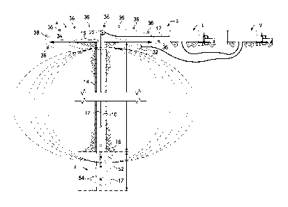
100111 Figure 1 is a schematic diagram, taken partly in cross-section, of a
borehole to surface
electromagnetic survey system disposed in a well borehole to obtain borehole
to surface
electromagnetic survey data according to the present invention.
- 4a -
CA 3055613 2021-04-15
CA 03055613 2019-08-28
WO 2018/164884 PCMJS2018/019997
[0012] Figure 2 is an enlarged view of a portion of the well casing of the
structure illustrated
in Figure 1.
[0013] Figure 3A is a schematic diagram of an upper portion of a borehole
to surface
electromagnetic transmitter according to the present invention.
[0014] Figure 3B is a schematic diagram of an intermediate portion of a
borehole to surface
electromagnetic transmitter according to the present invention.
[0015] Figure 3C is a schematic diagram of a lower portion of a borehole to
surface
electromagnetic transmitter according to the present invention.
[0016] Figure 4 is an example display of well log data from conventional
well logs regarding
subsurface formations as a function of depth in a well borehole.
[0017] Figure 5 is a plot of induced polarization data obtained from
subsurface formations
over a range of depths during borehole to surface electromagnetic surveying
and mapping of
subsurface formations adjacent the well borehole in which the well log data of
Figure 4 was
obtained.
[0018] Figure 6 is a plot of induced polarization data obtained from
subsurface foi in ati on s
over a different range of depths than Figure 5 during borehole to surface
electromagnetic
surveying and mapping of subsurface formations adjacent the well borehole in
which the well
log data of Figure 4 was obtained
[0019] Figure 7 is a schematic diagram of a computer system for processing
of borehole to
surface transmitter data according to the present invention.
-5-
CA 03055613 2019-08-28
WO 2018/164884 PCT/US2018/019997
[0020] Figure 8 is a functional block diagram of a set of data processing
steps performed in
the computer system of Figure 7 during the processing of borehole to surface
transmitter data
according to the present invention.
DETAILED DESCRIPTION OF THE PREFERRED EMBODIMENTS
[0021] In the drawings, a borehole to surface electromagnetic (BSEM) survey
system B is
shown schematically in Fig. 1 in connection with a well borehole 10 which has
been drilled into
the earth through rock in subsurface earth formations F having hydrocarbon
fluids of interest
An electromagnetic energy transmitter T (Figures 3A, 3B and 3C) according to
the present
invention is mounted with a wireline 12 for electromagnetic surveys of the
subsurface earth
formations F from the well borehole 10. As is typical, the well borehole 10
has a casing 14
(Figures 1 and 2) installed along its extent into the earth to a location near
a reservoir. A typical
casing string 14 extends several thousands of feet from wellhead 15 at or
above ground level to a
lowermost casing section or casing shoe 16 within the wellbore 10. Below the
depth of the
casing shoe at 16, the lower portion of the well where no casing is present is
what is known as
open hole 17.
[0022] The casing 14 is formed of lengths of tubular joint members 18
(Figure 2) connected
at upper and lower end portions 18a and 18b to adjacent tubular members 18 by
casing collars
20. The ends of each tubular joint or segment 18 of casing string 14 are
externally threaded, and
the collars 20 are internally threaded to mate with the threaded portion of
the adjacent casing
members 18. As is conventional, where two pieces of casing pipe 18 are joined
with a collar 20,
there may in some wells be a small gap between the adjacent ends of the two
sections of casing
Alternatively, in what is known as "flush joint" casing, no gap is present
between the ends of
adjacent casing member sections which are held in abutting relationship by
collar 20.
-6-
CA 03055613 2019-08-28
WO 2018/164884 PCT/US2018/019997
[0023] In connection with borehole to surface electromagnetic (BSEM)
surveys, the
transmitter T and wireline cable 12 are suitably supported at the wellhead 15
such as by a sheave
wheel 22, which is used to raise and lower the transmitter T in the wellbore
10. During the
borehole-surface or borehole to surface electromagnetic surveys, two
electrodes are used. A first
electrode 30 (Figure 3B) of the transmitter T according to the present
invention is in the well
borehole 10, which serves as the transmitter well to transmit electromagnetic
energy of desired
frequency and amplitude into earth formations around the well borehole for
travel through the
subsurface earth formations F. The other electrode 32 (Figure 1), which may be
a ground
electrode, is at the earth's surface 34 along with a receiver array A
indicated schematically in
Figure 1. The receiver array A is composed of electromagnetic energy receivers
36 located at
spaced positions on the earth over a surface area conforming to dimensions of
a reservoir of
interest. Receivers in the receiver array A detect the transmitted energy
field after passage
through the earth from the transmitter electrode T. A borehole to surface
electromagnetic survey
allows mapping of the fluid (typically oil and water) distribution in large
areas of the reservoir a
few (typically 2-4) kilometers away from the well in which the transmitter
electrode had been
positioned. Parameters of interest in such a survey are resistivity and
induced polarization or IP,
as will be set forth.
[00241 The transmitter electrode T located in the well 10 is activated at
depths of interest.
The resultant electromagnetic field is sensed in the time and frequency
domains by the receiver
array A. Surveys of this type are repeatable at required intervals over a
period of time to track
migration of subsurface fluids.
[0025] The electromagnetic energy transmitter T includes a conductive metal
bar or rod 40 of
copper or other similar conductive material. The conductive electrode energy
source 40 is
-7-
CA 03055613 2019-08-28
WO 2018/164884 PCT/US2018/019997
operatively connected to a control circuit 42 which responds to control
signals sent from the
surface from a transmitter vehicle V at the surface over the wireline 12 and
activates the
conductive electrode 40 to emit electromagnetic energy of the desired
frequency and amplitude
for a selected time and duration during BSEM surveying
[0026] According to the present invention, the borehole depths at which the
BSEM survey
electromagnetic energy is emitted by the transmitter T during surveys are
obtained in a manner
to be set forth. The borehole depth readings are recorded along with the
sensed electromagnetic
fields corresponding to emissions at that depth in a suitable data memory in a
computer or data
processor in a logging vehicle or truck L (Figure 1). Once recorded, the BSEM
data and depth
measurements are transferred as needed into the data processing system or
computer for on-site
processing and analysis and are available tor further processing and analysis
elsewhere. Records
of the time and content of the electromagnetic energy specified by control
signals are also
furnished from the transmitter vehicle V to data recoding computer or
processor equipment in the
logging vehicle or truck L.
[0027] The electromagnetic energy transmitter T also includes a sonde body
44 (Figure 3A
and 3B) connected to the wireline 12 by an upper connector subassembly 46. The
transmitter T
is adapted to be lowered by the wireline 12 in the well borehole 10 to the
various depths
indicated as adjacent or near the formations of interest for BSEM surveying.
The upper
connector subassembly 46 is mounted above the sonde body 44 operatively
coupling the control
circuit 42 to the wireline 12 to provide electrical energy as well as
mechanical connection for the
transmitter T. The upper connector subassembly 46 permits the flow of
electrical current to
provide power for signals emitted by the electromagnetic energy source 40
during surveys and
passage of control signals to the control circuit 42.
-8-
CA 03055613 2019-08-28
WO 2018/164884 PCT/US2018/019997
[0028] With the present invention, the electromagnetic energy transmitter T
is provided with
a casing collar locator 50 mounted within the sonde body 44 and electrically
connected through
connector subassembly 46 and wireline 12 with surface electronics in the
logging vehicle L to
provide indications of movement of the transmitter T and sonde body 44 past
casing collars 20 in
the casing string 14 during movement of the transmitter T through the well
borehole 10. The
casing collar locator 50 may be one of several available types, such as those
available from
Sondex (General Electric Co.) of Hampshire, UK. In the casing collar locator
50, magnetic
sensors detect the presence of casing collars 20 by sensing larger metallic
mass at the location of
the casing collar at the ends of the sections 18 of casing than along the
length of the casing
sections 18.
[0029] Electronic circuitry within the casing collar locator 50 tbrms
electrical signals usually
in the folin of pulses as the locator passes successive casing collars 20
during movement of the
transmitter T through the well borehole 15. The casing collars 20 are located
at defined known
lengths from each other according to the known distance or length of a casing
section 18 between
its ends 18. Thus a count of the number of casing collars 20 passed during
movement of the
transmitter to a target depth such as shown at 52 or 54, for example either in
the open hole region
17 or within the casing string 14 indicates accurately for the purposes of the
present invention the
depth of the transmitter T. The casing collar locator 50 thus measures the
position of the
transmitter T relative to the last casing point or casing shoe at depth 16.
The casing collar
locator 50 is provided with on-off switching capability so that measurements
are not being made
with the locator during the transmission of electromagnetic signals from the
transmitter T. Thus,
the casing collar locator 50 is sensing and transmitting signals indicating
the presence of casing
-9-
CA 03055613 2019-08-28
WO 2018/164884 PCT/US2018/019997
collars only at those times when the locator is passing through the casing
shoe 16 before entering
in the target zone
[0030] The transmitter T of the present invention thus compensates for any
potential bias or
distortion in the accuracy of depth locations at which the transmitter T is
activated which are
induced by the elongation of the wireline cable from surface to the target
depth. This has been
found to be satisfactorily accurate even when the transmitter is located at a
depth in open hole
17. Normally there are only a few feet of open hole section at the end of a
cased well. The
possible elongation of the cable in the last few feet of open-hole has been
found to be negligible
compared to the thousands of feet in the cased section 14.
[0031] The electromagnetic energy transmitter T in accordance with the
present invention is
also provided with a pressure and temperature sensing capability which
includes a fluid pressure
sensor 55 and a temperature sensor 60 mounted in the sonde body 44. The fluid
pressure sensor
55 measures fluid pressure in the well borehole at the location of the sonde
body 44 within the
wellbore 10. The fluid pressure sensor 55 is electrically connected with
surface electronics in the
logging vehicle L to provide indications of fluid pressure at the location of
transmitter T. The
pressure sensor 55 may be one of several available types, such as those
available from Omega
Data Services Limited of Aberdeen, Scotland.
[0032] The temperature sensor 60 measures fluid pressure in the well
borehole at the location
of the sonde body 44 within the wellbore 10. The temperature sensor 60 is
electrically connected
with surface electronics in the logging vehicle L to provide indications of
temperature conditions
at the location of transmitter T. The temperature sensor 60 may be one of
several available
types, such as those available from Omega Data Services Limited of Aberdeen,
Scotland.
-10-
CA 03055613 2019-08-28
WO 2018/164884 PCT/US2018/019997
[0033] According to the present invention, it is now possible to monitor
the downhole
conditions of pressure as well as temperature during BSEM surveys In this
manner, well crews
are able to identify and take steps to prevent a potential problem from
occurring. Examples of
such potential problems are overheating of the transmitter electrode T; an
ignition starting in the
well borehole, a gas kick in the well, an overpressure condition, and the
like. Accordingly,
survey crews and well crews are able to sense and detect conditions which
might give rise to the
risk of blowout or ignition, or might affect the quality of data.
[0034] It has also been found that due to the very low electromagnetic
frequency typically
used in BSEM surveys, energy emitted during the surveys does not affect the
pressure and
temperature measurements sensed by the sensors 55 and 60, respectively. The
electromagnetic
current could, however, affect pressure and temperature conditions downhole.
The present
invention by including pressure sensors and temperature sensors integrated in
the BSEM
transmitter T is able to detect possible anomalous increase of temperature or
pressure, or both,
due to a number of reasons. Examples are overheating of the BSEM transmitter
electrode or
antenna 30, with the risk of melting the transmitter T or wireline cable 12;
an anomalous
hydrocarbon overpressure bubble entering the well; and possible ignition of
gases started
downhole, whether or not triggered by the electromagnetic current emitted. The
pressure and
temperature readings sensed with the present invention are important for
timely preventive
measures to be taken at the surface, such as stopping transmission of the BSEM
signals,
activating the well control procedures, emergency measures as required.
[0035] A lower connector subassembly 70 (Figure 3B) is mounted below the
sonde body 44
and connects the conductive metal bar 40 of electrode 30 source to the control
circuit 42 so that
-11-
CA 03055613 2019-08-28
WO 2018/164884 PCT/US2018/019997
electrical power is provided to the metal bar 40 to emit electromagnetic
energy of the desired
frequency and amplitude for a selected time and duration during BSEM
surveying.
[0036] The conductor bar 40 is a solid bar of requisite thickness for
mechanical strength
formed of copper and is, for example about 0.8m in length. A weight bar
connector 72 is
mounted at a lower end of conductor bar 40 to connect a swivel connector
subassembly 74 with
upper portions of the transmitter T The swivel connector subassembly 74
provides as indicated
schematically at 76 for pivotal movement and connection of a weight bar member
78 of a
suitably heavy material to the upper portions of the transmitter T. The weight
bar member 78
assists as is conventional, in proper orientation and movement of the
transmitter T in the well
borehole 10. Typically, as indicated at 80 a nose plug is mounted below the
weight bar 78 for
facilitating movement of the transmitter '1 through the well borehole 10.
[0037] In the operation of the present invention borehole to surface
electromagnetic surveying
of subsurface earth formations is performed in the well borehole 10 when the
transmitter T with
sonde body 44 are lowered to locations of interest in the borehole in the free
hole zone 17
borehole below the casing 18. A measure is formed, during such movement, with
the casing
collar locator 50 of the number of casing collars 20 past which the
transmitter and sonde body
travel during lowering and the measurements forwarded to the surface over the
wireline 12 and
recorded in the logging truck L. In this manner, the depth of the transmitter
T in the borehole 10
is measured and recorded based on the measured number of casing collars. The
casing collar
locator 50 is then deactivated when transmitter T are at a location of
interest. Electromagnetic
energy is then emitted from the conductive bar 40 at the location of interest
to travel through the
subsurface formations for electromagnetic energy surveying of the subsurface
earth formations.
-12-
CA 03055613 2019-08-28
WO 2018/164884 PCT/US2018/019997
[0038] Figure 4 is a simplified example display of well log data from
conventional well logs
as a function of borehole depth regarding subsurface formations as a function
of depth in the well
borehole 10. The well log or plot in Figure 4 illustrate as a function of
depth over a range of
porosity values from below 5% to about 25% the relative presence of oil as
indicated at 100 and
water as indicated at 102. The measurements from which the data displayed in
Figure 4 were
attained from an example well in an existing reservoir.
[0039] Another measurement of interest in addition to the well logs of
Figure 4 obtainable
from the same subsurface formations is data obtainable from BSEM surveys. One
of the
parameters obtainable from data from BSEM surveys of subsurface earth
formations from a well
borehole is Induced Polarization or IP. Plots or maps of induced polarization
for an investigative
layer in the subsurface formations are utilized in discriminating oil from
water zones in the
formations near or even within a few kilometers from the well borehole. If the
induced
polarization maps obtained from BSEM survey data indicate a high induced
polarization
measure, this indicates that there is a high oil saturation in the
investigated layer. Conversely, if
the induced polarization maps obtained from BSEM survey data indicate a low
induced
polarization measure, this indicates that there is a water saturation in the
investigated layer.
[0040] Figure 5 is a plot or map of induced polarization as a function of
surface area or extent
based on BSEM survey data for a layer indicated as extending from depth Al
through depth A4
in the well which is the subject of the well logs plotted in Figure 4. For
ease of reference and
analysis, the well log plot is also included in Figure 5. The induced
polarization measurements
as determined from BSEM surveys are plotted in the color key 104 for the map
of Figure 5. The
locations or depths so indicated in the well of depths Al and A4 are depicted
in the well log plots
of Figure 4 and 5.
-13-
100411 Figure 6 is a plot or map of induced polarization based on BSEM
survey data for a
layer determined according to the present invention as extending from the
depth Al through
depth A2 in the same well which is the subject of the well logs plotted in
Figure 4. For ease of
reference and analysis, the well log plot is also included in Figure 6. The
depth A2 is also
indicated in the well log plotted in Figure 4 along with depths Al and A4. The
map co-ordinates
are plotted in the margins of Figure 6 As is evident, the areas which are the
subject of Figures 5
and 6 substantially overlap. The induced polarization measurements as
determined from BSEM
surveys are plotted in the color key 104 for the map of Figure 5 which is the
same as that of
Figure 6.
100421 In the induced polarization maps of Figures 5 and 6 the differences
of induced
polarization response are apparent. In the map of Figure 5, the induced
polarization data map
provides indications of oil as indicated by the areas in the upper right
quadrant of the map when
the transmitter is located at the layer between depths Al and A4. Conversely,
the induced
polarization data map of Figure 6 which refers to the layer Al and A2
indicates the presence of
substantially more water in the same general area of the reservoir ,of
interest, with water
indicated in the same reservoir area.
[0043] As illustrated in Fig. 7, a data processing system D according to
the present invention
for processing of borehole to surface transmitter data includes a computer 120
having a processor
122 and memory 124 coupled to the processor 122 to store operating
instructions, control
information and database records therein. The computer 120 may, if desired, be
a multicore
processor with nodes such as those from Intel Corporation or Advanced Micro
Devices (AVID),
or a mainframe computer of any conventional type of suitable processing
capacity such as those
available from International Business Machines (IBM) of Armonk, N.Y. or other
source.
-14-
CA 3055613 2020-07-27
[0044] It should be noted that other digital processors, may be used, such
as personal
computers in the form of a laptop computer, notebook computer or other
suitable programmed or
programmable digital data processing apparatus.
[0045] The computer 120 has a user interface 126 and an output display 128
for displaying
output data or records of processing of processing of borehole to surface
transmitter data and
other logging data measurements performed according to the present invention
to obtain
measures of interest for electromagnetic surveying and mapping of subsurface
formations. The
output display 128 includes components such as a printer and an output display
screen capable of
providing printed output information or visible displays in the form of
graphs, data sheets,
graphical images, data plots and the like as output records or images.
[0046] The user interface 126 of computer 120 also includes a suitable user
input device or
input/output control unit 130 to provide a user access to control or access
information and
database records and operate the computer 120. Data processing system D
further includes a
database 132 stored in memory, which may be internal memory 124, or an
external, networked,
or non-networked memory as indicated at 134 in an associated database server
136.
[0047] The data processing system D includes program code 138 stored in
memory 124 of the
computer 120. The program code. 138, according to the present invention is in
the form of
computer operable instructions causing the data processor 122 to obtain a
measure of
transmissibility of fluid in subsurface formations, as will be set forth.
[0048] It should be noted that program code 138 may be in the form of
microcode, programs,
routines, or symbolic computer operable languages that provide a specific set
of ordered
operations that control the functioning of the data processing system D and
direct its operation.
-15-
CA 3055613 2020-07-27
The instructions of program code 138 may be stored in memory 124 of the
computer
120, or on computer diskette, magnetic tape, conventional hard disk drive,
electronic read-only
memory, optical storage device, or other appropriate data storage device
having a computer
usable medium stored thereon. Program code 138 may also be contained on a data
storage
device such as server 136 as a computer readable medium, as shown.
[0049] A flow chart C of Figure 8 herein illustrates the structure of the
logic of the present
invention as embodied in computer program software. Those skilled in the art
appreciate that the
flow charts illustrate the structures of computer program code elements that
function according
to the present invention. The invention is practiced in its essential
embodiment by computer
components that use the program code instructions in a form that instructs the
digital data
processing system D to perform a sequence of processing steps corresponding to
those shown in
the flow chart C.
[0050] With reference to Figure 8, the flow chart C is a high-level logic
flowchart illustrates a
method according to the present invention of processing of borehole to surface
transmitter data to
obtain measures of interest for electromagnetic surveying and mapping of
subsurface formations.
The method of the present invention performed in the computer 120 can be
implemented
utilizing the computer program steps of Figure 8 stored in memory 124 and
executable by system
processor 122 of computer 120. The survey and logging data resulting from
measurements taken
with the survey system B of Figure I are provided as inputs to the data
processing system D.
[0051] As shown in the flow chart C of Figure 8, a preferred sequence of
steps of a computer
implemented method or process for obtaining measures of interest for
electromagnetic surveying
and mapping of subsurface formations according to the present invention is
illustrated
-16-
CA 3055613 2020-07-27
schematically. During step 200, data is obtained for further processing from
borehole to surface
electromagnetic surveying by electromagnetic signals sent from the borehole
transmitter T and
detected by the receivers in the surface array A in the manner described
above. Additionally,
data regarding the transmitter depths, receiver location positions or co-
ordinates, synchronized
time of transmission, transmission signal parameters (amplitude, phase,
frequency), geological
layer, and topography are assembled during step 200.
[0052] During step 202, the data assembled during step 200 are processed to
determine the
detected electromagnetic field between the borehole source T at the depth or
depths of interest
and selected receivers of the receiver array A. It should be understood that
the entire group of
receivers in the array A may be selected, if desired.
[0053] The processing during step 202 to determine the detected
electromagnetic field can be
performed in the time domain or the frequency domain and can be performed
according to
7/1
several conventional methods. Examples include multidimensional inversion and
Occam
inversion such as "Occam's Inversion: A Practical Algorithm for Generating
Smooth Models
from Electromagnetic Sounding Data, S. Constable, R. Parker, and C. Constable,
Geophysics,
Vol. 52, No. 3 (March 1987): P 289-300". It should be understood that other
suitable
methodologies to determine the detected electromagnetic field can also be used
during
performance of step 202.
100541 The detected electromagnetic fields obtained during processing in
step 202 are
stored in appropriate memory of the data processing system D during step 204
as functions of
depth in the borehole 10. The data stored during step 204 is then available as
electromagnetic
-17-
CA 3055613 2020-07-27
CA 03055613 2019-08-28
WO 2018/164884 PCT/US2018/019997
well logs as functions of borehole depth in the subsurface formation of
interest for further
analysis and study.
[0055] During step 206, the processed data from step 202 are also stored in
memory
according to the particular grouping of receivers selected in the array A. The
data stored during
step 206 is then available as electromagnetic field mapping data regarding the
subsurface
formation of interest for further analysis and study
[0056] During step 208, the assembled data from step 200 and the processed
data from step
202 are processed to determine induced polarization or IP in selected
formations at locations or
depths of interest in subsurface formation F. During step 210, induced
polarization for selected
receivers in the array A are determined and assembled. Again, the entire array
may be selected
as a group if desired.
[0057] Processing during step 208 to determine induced polarization can be
done, for
example, by either inversion or analytically. Examples of such processing are
those described in
the article, "Induced Polarization Interpretation for Sub surface
Characterisation: A Case Study of
Obadore, Lagos State", Alabi, Ogungbe, Adebo, and Lamina, Scholars Research
Library,
Archives of Physics Research, (2010), 1 (3):34-43. The processing during step
208 is performed
to determine variations of apparent resistivity as a function of different
transmitted
electromagnetic frequencies. This dispersion behavior is related to the
relative presence of water
and hydrocarbons, as described in the article, "Carbonate Reservoir Rocks Show
Induced
Polarization Effects, Based on Generalized Effective Medium Theory", Zhdanov,
Burtman, and
Marsala, 75th EAGE Conference & Exhibition, SPE EUROPE 2013, London, UK, (10-
13 June
2013).
-18-
100581 The determined induced polarization in the portions or regions of
interest in the
subsurface formation F resulting from steps 208 and 210 are then stored in
appropriate memory of
the data processing system D during step 212. During step 214, selected ones
from one or more
types of the electromagnetic well log data, electromagnetic field data and
induced polarization
data in subsurface formations of interest resulting from the processing are
made available in
response to user requests in the subsurface formation of interest for further
analysis and study.
100591 Accordingly, with the present invention a more precise measure and
knowledge of the
depth where electromagnetic signal energy is being transmitted is provided. A
more accurate
reading of the depth location of the transmitting antenna or electrode 30 is
available. It can be
seen that if the location of the electromagnetic transmitter antenna 30 is
properly indicated at A2
instead of A4 a markedly different map of fluid distribution is obtained and
measured for the
selected reservoir layer It can also be seen that thus it is now possible to
have an accurate
measurement of the depth position of the BSEM transmitter T downhole
[0060] The invention has been sufficiently described so that a person with
average knowledge
in the matter may reproduce and obtain the results mentioned in the invention
herein
Nonetheless, any skilled person in the field of technique, subject of the
invention herein, may
carry out modifications not described in the request herein, to apply these
modifications to a
determined structure, or in the manufacturing process of the same, requires
the claimed matter in
the following claims; such structures shall be covered within the scope of the
invention.
10061] It should be noted and understood that there can be improvements and
modifications
made of the present invention described in detail above without departing from
the spirit or
scope of the invention as set forth in the accompanying claims.
-19-
CA 3055613 2020-07-27