Note : Les descriptions sont présentées dans la langue officielle dans laquelle elles ont été soumises.
CA 03055718 2019-09-06
WO 2018/190724
PCT/N02018/050094
1
Description
SYSTEM FOR DETERMINING A POSITION ON A GOLF COURSE
The present invention relates to a system for determining a position on a golf
course.
A golf course is an area comprising a series of holes, in which the game of
golf is
played. Typically, a golf course with 18 holes occupies as much as 60 hectares
(approximately 150 acres) of land and has an average of 30 hectares
(approximately 74
acres) of maintained turf. Determining a position on a golf course is useful
in several
circumstances. One example is providing an autonomous vehicle to perform a
maintenance task on the golf course, such as cutting grass, picking up trash,
or
removing dew. The ability to determine the current position allows the
autonomous
vehicle to, for example, process a trajectory, move along an appropriate path
on the golf
course, or decide which movement to perform next. Another example is a golf
player
deciding on how to perform a stroke during a round of golf. When making that
decision,
an important information to consider is the distance from the position of the
ball being
played to the target hole. The distance can be obtained if the player knows
the position
of the hole before-hand and is able to determine his/her position on the golf
course.
However, there are challenges in determining a position with accuracy on the
golf
course. A significant error can sabotage the action that is performed based on
the
determined position. For example, an autonomous lawn mower will require
accurate
positions to be determined when cutting the grass on a putting green,
otherwise the
resulting putting green may differ from the planned design. Or the autonomous
lawn
mower will require accurate positions to be determined when circumventing
hazards,
such as bunkers or water streams, otherwise it may move into a location that
will block it
from moving further or even damage it. Another example, is a player selecting
an
incorrect club when performing a stroke, the selection being performed based
on an
incorrect determination of his/her position, of the position of the ball,
and/or of the
position of a hole on the golf course.
A known solution for determining a position on a golf course is a receiver for
a satellite
navigation system such as the Global Positioning System (GPS), the GLONASS
(GlobeInaya Navigazionnaya Sputnikovaya Sistema), or the Galileo system.
However,
CA 03055718 2019-09-06
WO 2018/190724
PCT/N02018/050094
2
in practice it is observed that the determined position will present an error
approximately
between 5 and 15 meters. With such an error, it is not safe, for example, for
an
autonomous lawn mower to move on a path that is 3 meters wide. A player will
also
determine his/her position with a significant error, which renders this
solution insufficient
in many situations.
The present invention will now be disclosed,
According to an aspect of the present invention there is provided a system for
determining a position on a golf course, the system comprising a master unit
and at
least one slave unit, wherein each of the master unit and the at least one
slave unit
comprises a processing unit, a memory, a receiver for a satellite navigation
system, and
are adapted to communicate through a telecommunications network, wherein the
receiver of the master unit is operable at a fixed position on the golf course
and the
memory of the master unit is configured with the fixed position, wherein the
master unit
is configured to:
- obtain a position determined by the receiver of the master unit;
- process the displacement between the obtained position and the fixed
position; and
- make the processed displacement accessible to the at least one slave unit
through the
telecommunications network, and
wherein a slave unit is configured to:
- obtain the displacement processed by the master unit through the
telecommunications
network;
- obtain a position determined by the receiver of the slave unit;
- filter the obtained position based on the obtained displacement.
By providing a master unit with a receiver for a satellite navigation system
and by
having the receiver to be operable at a known fixed position on the golf
course it
becomes possible to compare the position determined by the receiver against
the fixed
position. This allows to process the displacement of the position determined
by the
receiver, in other words an error. It has been realised that, if the
displacement is made
available to the at least one slave unit, the latter can then make use of it
to improve any
position determined therein. Thus, although the system may process the
displacement
CA 03055718 2019-09-06
WO 2018/190724
PCT/N02018/050094
3
at a fixed location, it still enables the at least one slave unit to improve
the determination
of its position, even if it changes its position on the golf course.
The configured step of the master unit to process the displacement may
comprise
processing the difference of latitude and longitude between the obtained
position and
the fixed position.
The configured step of the slave unit to filter the obtained position based on
the
obtained displacement may comprise correcting the obtained position based on
the
inversion of a difference of latitude and longitude processed by the master
unit.
The system may comprise a server adapted to communicate through the
telecommunications network, the server comprising a database for storing a
displacement processed by the master unit, wherein the configured step of the
master
unit to make the processed displacement accessible to the at least one slave
unit
through the telecommunications network, comprises:
- communicating the processed displacement to the server through the tele-
communications network, and
wherein the configured step of the slave unit to obtain the displacement pro-
cessed by
the master unit through the telecommunications network, comprises:
- communicating with the server through the telecommunications network so as
to
obtain the processed displacement.
The database of the server may also be for storing at least one filtered
position of a
slave unit, wherein the slave unit is further configured to communicate the
filtered
position through the telecommunications network to the server, wherein a
second slave
unit is configured to:
- communicate with the server through the telecommunications network so as to
obtain
the filtered position of the slave unit;
- calculate the distance between the filtered position of the second slave
unit and the
filtered position of the slave unit.
CA 03055718 2019-09-06
WO 2018/190724
PCT/N02018/050094
4
According to another aspect of the present invention there is provided a golf
course
comprising the system described above. At least one hole of the golf course
may
comprise a slave unit.
According to a further aspect of the present invention there is provided a
flag for
marking the position of a hole on a golf course, the flag comprising a slave
unit of the
system as described above.
According to a further aspect of the present invention there is provided a
portable
device for determining a position on a golf course, the portable device
comprising a
slave unit of the system as described above.
According to a further aspect of the present invention there is provided an
autonomous
vehicle operable to move on a golf course, comprising a slave unit of the
system as
described above. The autonomous vehicle may be an autonomous lawn mower.
Embodiments of the invention will now be described by way of example with
reference
to the accompanying drawings in which:
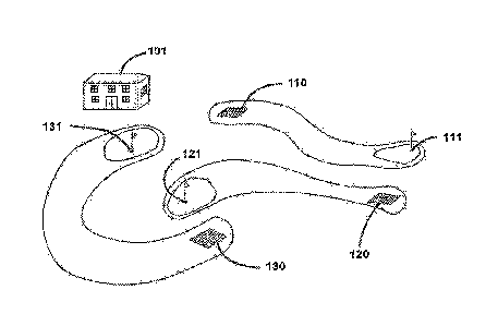
Figure 1 illustrates a golf course;
Figure 2 illustrates an embodiment of a master unit and an embodiment of a
flag
comprising a slave unit;
Figure 3 illustrates how a slave unit may improve its determination of a
position on the
golf course;
Figure 4 illustrates a golf player measuring the distance to a flag.
Figure 1 illustrates a golf course in which there is a clubhouse 101 and three
holes (111,
121, and 131). Notwithstanding that a golf course typically has a number of
holes that is
multiple of 9 (due to a round of golf normally consisting of 9 or 18 holes),
figure 1
includes only three holes for the purpose of simplifying its drawing.
Typically, the
clubhouse 101 of a golf course serves as an entry point and as a meeting
place,
providing facilities such as a locker room, a restaurant, or a pro shop.
Usually, the golf
course is arranged so that the clubhouse 101 is near the start¨in figure 1 the
start is
the teeing ground 110¨and the end¨in figure 1 the end is the hole 131¨of a
CA 03055718 2019-09-06
WO 2018/190724
PCT/N02018/050094
sequence of holes. Also, the clubhouse 101 is normally situated at a location
with a
good visibility to most holes of the golf course.
In the golf course illustrated in figure 1, a round of golf consisting of the
three holes
5 therein (111, 121, and 131) could be played by starting from the teeing
ground 110. A
ball would be played from there with successive strokes until it would be at
rest within
the hole 111. Then, moving to the second teeing ground 120, the ball would be
played
towards the hole 121. And finally, moving to the third teeing ground 130, the
ball would
be played towards the hole 131. The player who finishes the three holes with
the lowest
number of strokes would win.
Figure 2 illustrates general invention embodiments of a master unit 201 and of
a slave
unit 202.
The master unit 201 includes a processing unit, a GPS receiver, and a memory
pre
configured with the fixed coordinates of the GPS receiver. The GPS receiver
could
instead be a receiver for any other satellite navigation system. The operation
of the
master unit 201 requires its memory to be configured with the fixed
coordinates of the
GPS receiver. Afterwards, these coordinates are used as a reference to compare
coordinates determined by the GPS receiver.
The master unit 201 also includes a communication interface for communicating
through the Internet. The connection may be performed by wire, for example via
Ethernet, or wirelessly, for example via WiFi or via a digital cellular
network.
The slave unit 202 is illustrated as being installed on a flag for marking the
position of
the hole 111 on the golf course. This arrangement is useful because it can be
used to
determine the position of the hole 111 with a few changes of the already
existing
elements of on the golf course.
Figure 3 illustrates a system invention embodiment showing how a displacement
301 is
processed by the master unit 201 and propagated to a slave unit 202, which
then uses it
to improve the position determined by the receiver of the slave unit 202.
CA 03055718 2019-09-06
WO 2018/190724
PCT/N02018/050094
6
For this example, the system comprises a server (not shown) remotely
assessible
through the Internet. Initially, the memory of the master unit 201 is
configured with the
fixed position at which the receiver of the master unit 201 is operating. This
may be
done by any prior art method for that purpose, such as by reading the
coordinates of the
fixed position using a map or by collecting position samples from the receiver
of the
master unit 201 during several days and, at the end, processing a statistical
indicator for
representing the fixed position.
After the initial configuration of the memory of the master unit 201, the
following occurs.
The master unit 201 obtains a position determined by its receiver and
processes the
displacement 301 by comparing the obtained position and the fixed position
configured
in its memory. In this respect, the master unit 201 processes the difference
of latitude
and longitude between the obtained position and the fixed position, which is
represented by the arrow 301 in the figure. Once the displacement 301 has been
processed, the master unit 201 may then communicate the processed displacement
301 to the server, for example via a wired connection to Internet. The server
stores the
displacement 301 data in its database. Thus, the master unit 201 makes the
displacement 301 available to the slave unit 202, which can then communicate
with the
server to obtain it.
The slave unit 202 communicates with the server through the Internet, for
example via a
wireless connection, and obtains the displacement 301. Then, the slave unit
202 obtains
a position determined by its receiver. This position is then filtered based on
the obtained
displacement 301. In particular, the slave unit 202 corrects the obtained
position based
on an inversion of the difference of latitude and longitude processed by the
master unit
201, ie the inverted displacement 302. Thus, the slave unit 202 processes a
filtered
position using the inverted displacement 302.
It will be appreciated that the inverted displacement 302 may be processed by
some
other component of the system, for example by the server or by the master unit
201
before communicating it to the server.
This system invention embodiment allows improving the determination of a
position at
the slave unit 202. Thus, the slave unit 202 may be installed on an autonomous
vehicle,
CA 03055718 2019-09-06
WO 2018/190724
PCT/N02018/050094
7
which would use the position determined by the embodiment as an input to its
navigation system. As described for figure 2 and illustrated in figure 4, the
slave unit 202
may also be installed on a flag for marking the position of a hole on a golf
course.
Figure 4 illustrates how a system invention embodiment may be installed and
used on a
golf course, so that a golf player is able to determine the distance from
his/her position
to the hole 111. In this example, the clubhouse 101 is chosen as the location
where the
master unit 201 is installed however any other location in the golf course
could have
been chosen. Further, the example includes two slave units: a slave unit 202
installed
on the flag of the hole 111, as illustrated in figure 2; and another slave
unit 401 being
carried by the golf player.
After the slave unit 202 has processed its filtered position in a similar
manner as
explained for figure 3, it then communicates this result to the server through
the internet,
which stores the result in its database. This arrangement may allow for the
server to
store filtered positions from several slave units in a centralised manner.
After having performed the tee-off stroke, ie the initial stroke performed
from the teeing
ground 110, the golf player now has to perform his/her next stroke from the
fairway, ie
the part of the golf course between the teeing ground 110 and the smooth area
of short
grass surrounding the hole 111 (known as the putting green). An important
information
for the golf player to consider when deciding on how to perform the next
stroke is the
distance from his/her current position to the hole 111.
A stroke is a movement of the club made with the intention of striking at and
moving the
ball. A player may decide on several aspects when performing the stroke. The
following
are a few examples. There are various kinds of clubs (eg wood, iron, or
putter) that the
player can choose from and each kind has different features to consider (eg
the length
of the shaft or the angle of inclination of its face). Another aspect to
decide upon is the
movement to be performed, for example a full swing, a three-quarter swing, or
any other
kind of swing. A further aspect is the position where the ball is struck at.
Any aspect
considered for the stroke will influence the way the golf player transmits
energy to the
ball.
CA 03055718 2019-09-06
WO 2018/190724
PCT/N02018/050094
8
In order to determine the distance, the golf player enables the slave unit 401
to operate
as follows. The slave unit 401 determines its filtered position in a similar
manner as the
slave unit 202 did: obtain the displacement processed by the master unit 101
from the
server; obtain the position determined by its receiver; and filter the obtain
position based
on the obtained displacement. Then, it obtains the filtered position of the
intended
target, which is slave unit 202. In particular, the slave unit 401
communicates with the
server to obtain this information. And then it calculates the distance between
the two
filtered positions.
This solution allows to solve a problem that is observed nowadays. In order to
save the
putting green surrounding a hole, many golf courses are managed so that the
wear due
to the golf player stepping on it is minimised. One strategy in particular, is
to regularly
move the hole and flag on the putting green. This may be achieved by removing
the
components of the hole, typically a cup with the appropriate dimensions,
filling in the
cavity left behind and covering it with pre-grown grass, and then inserting
the
components of the hole in another location of the putting green. This has the
advantage
for the owners of the golf course that the wear of the putting green is spread
throughout
in an homogenous manner. However, this strategy also has the consequence that
the
hole will be changing position regularly within a significant area, typically
with 500
square meters. Consequently, many prior art solutions using a centralised
database
with positions of holes will provide an error of several meters when
estimating the
distance between an initial position on the golf course and a hole,
independently of the
accuracy of the initial position on the golf course. The present invention,
and in
particular the example explained with reference to figure 4, allows solving
this problem.
Invention embodiments may have some or all of the following advantages:
* Although the master unit has to be at a fixed location in order to
process the
displacement, any slave unit may move on the golf course
* A golf player may use the system to measure a distance to a target
without
requiring direct line of sight with the target
* The quality of a measurement of a distance to a target does not depend on
the
reflectivity or any other physical property of the target
CA 03055718 2019-09-06
WO 2018/190724
PCT/N02018/050094
9
= The slave unit being carried by a player does not need to be manoeuvred
steadily; the player's hands may shake and that will not interfere
significantly with
the determination of a position
# The system is used in the same manner to measure the distance to any
target,
independently of the starting position; measuring a distance from the teeing
ground is as easy as measuring a distance from the fairway
= The location of the holes of the golf course may be changed over time
without
requiring additional work to measure their coordinates: a flag, comprising a
slave
unit, may be simply moved to a new location and it will automatically update
its
coordinates
* An overall improvement of the accuracy determining a position in the
vicinity of
the master unit
Generally, the terms used in this description and claims are interpreted
according to
their ordinary meaning the technical field, unless explicitly defined
otherwise.
Notwithstanding, the terms "comprises" and "comprising" and variations thereof
mean
that the specified features, steps or integers are included. These terms are
not
interpreted to exclude the presence of other features, steps or integers.
Furthermore,
the indefinite article "a" or "an" is interpreted openly as introducing at
least one instance
of an entity, unless explicitly stated otherwise. An entity introduced by an
indefinite
article is not excluded from being interpreted as a plurality of the entity.
The features disclosed in the foregoing description, or in the following
claims, or in the
accompanying drawings, expressed in their specific forms or in terms of a
means for
performing the disclosed function, or a method or process for obtaining the
disclosed
results, as appropriate, may, separately, or in any combination of such
features, be
utilised for realising the invention in diverse forms thereof.
While the invention has been described in conjunction with the embodiments
described
above, many equivalent modifications and variations will be apparent to those
skilled in
the art when given this disclosure. Accordingly, the embodiments of the
invention set
forth above are considered to be illustrative and not limiting. Various
changes to the
described embodiments may be made without departing from the spirit and scope
of the
invention.