Note : Les descriptions sont présentées dans la langue officielle dans laquelle elles ont été soumises.
CA 03074570 2020-02-26
SAFE DRIVING ASSISTANCE DEVICE
TECHNICAL FIELD
[0001]
The present invention relates to a safe driving assistance
technique that prevents a rear end collision and a collision of
vehicles in a mine.
BACKGROUND ART
[0002]
In a mine, a construction site, and the like, a heavy haulage
vehicle, such as a dump truck, is used. There is a technique to
detect a shoulder in order to avoid a collision between vehicles
and prevents falling under such an environment. For example,
Patent Literature 1 discloses a technique that "includes shoulder
detecting sections to scan a road surface in front of a vehicle in
the traveling direction of the vehicle to detect a shoulder located
on the road surface and a shoulder measuring device to measure the
orientation of the vehicle relative to the shoulder detected by the
shoulder detecting sections and the distance to the shoulder; and
the two shoulder detecting sections are installed on the traveling
direction side of the vehicle. The two shoulder detecting sections
are installed in a higher position than the upper ends of the front
wheels (excerpt from ABSTRACT)."
[0003]
In a mine, a construction site, and the like, a mound (berm)
1
CA 03074570 2020-6
is formed as a safety facility in order to physically separate a
travel route. In Patent Literature 2, there is disclosed a
technique in which "a control system that includes a communicating
device, a locating device configured to generate a first signal
indicative of a location of a machine, and a sensor configured to
generate a second signal indicative of contact of a machine with a
berm is disclosed. This control system may also have an offboard
controller configured to generate a first set of coordinates of a
dump target, and to assign the first set of coordinates to the
onboard controller for use in controlling the machine. The
offboard controller may also be configured to detect contact of the
machine with the berm based on the second signal during reverse
travel toward the dump target, and to generate a second set of
coordinates of the dump target to correspond with a location of the
machine at a time of contact detection (excerpt from ABSTRACT)."
[0004]
Furthermore, Patent Literature 3 discloses a technique that
"disposes a transmitter and a receiver on each unmanned self
traveling body to confirm a position of a preceding unmanned self
traveling body, and determines whether positional data of another
preceding unmanned self traveling body is within an area where a
collision is possible or not, to prevent the collision."
Specifically, there is disclosed a technique that "disposes a
transmitting device that transmits positional data of itself
calculated with a position detection device and a receiving device
2
CA 03074570 2020-02-26
that receives another piece of positional data transmitted by
another unmanned self traveling body in each unmanned self
traveling body, and is configured to perform an operation following
a planned traveling course by a guide control device while a
collision prevention system calculates an emergency stop area El,
an ordinary stop area E2, a second deceleration area E3, and a
first deceleration area E4 in order from high risk based on the
positional data of itself, and controls the unmanned self traveling
body to an emergency stop, an ordinary stop, a second deceleration,
or a first deceleration to prevent a collision when the above
described received positional data of another unmanned self
traveling body is within the above described area(excerpt from
ABSTRACT)."
CITATION LIST
PATENT LITERATURE
[0005]
PATENT LITERATURE 1: JAPANESE UNEXAMINED PATENT APPLICATION
PUBLICATION NO. 2015-210734
PATENT LITERATURE 2: U52014/0214237A1
PATENT LITERATURE 3: JAPANESE UNEXAMINED PATENT APPLICATION
PUBLICATION NO. H05-127747
3
CA 03074570 2020-6
SUMMARY OF INVENTION
TECHNICAL PROBLEM
[0006]
However, warning by determining a collision risk using only a
positional relationship with detected another vehicle in some cases
generates a warning even though there exists a safety facility,
such as a mound, in between. That is, it is highly possible that
the system is low in reliability with low warning generation
accuracy.
[0007]
The present invention has been made in consideration of the
above described circumstance, and it is an objective of the present
invention to provide a technique that warns a collision risk with
high accuracy to assist safe driving.
SOLUTION TO PROBLEM
[0008]
The present invention provides a safe driving assistance
device that includes a position detecting device, a vehicle speed
sensor and a steering angle sensor, a storage device, an
environment recognition device, a vehicle-to-vehicle communication
device, a region setting section, and a determination section. The
position detecting device obtains current position information of a
vehicle. The vehicle speed sensor and the steering angle sensor
obtain travel data including a traveling direction and a speed.
The storage device stores a vehicle specification including a size
4
CA 03074570 2020-6
of the vehicle. The environment recognition device obtains
environment data including an altitude of a geography. The
vehicle-to-vehicle communication device wirelessly and
communicatively couples the vehicle to another vehicle. The region
setting section sets a collision risk determination region used for
determining presence or absence of a collision risk of a host
vehicle. The determination section sets a host vehicle collision
risk determination region, which is the collision risk
determination region of the host vehicle, based on travel data of
the host vehicle, the vehicle specification of the host vehicle,
and the environment data obtained by the host vehicle, obtaines an
other vehicle collision risk determination region, which is the
collision risk determination region of the other vehicle as a
collision risk determination target with the host vehicle set by
the other vehicle, set by the other vehicle through the vehicle-to-
vehicle communication device, and determines a collision risk
between the host vehicle and the other vehicle using the host
vehicle collision risk determination region, the other vehicle
collision risk determination region, and environment data.
ADVANTAGEOUS EFFECTS OF INVENTION
[0009]
The present invention ensures warning a collision risk with
high accuracy to assist a safe driving. Note that problems,
configurations, and effects other than those described above will
CA 03074570 2020-02-26
be clarified by explanation of embodiments described below.
BRIEF DESCRIPTION OF DRAWINGS
[0010]
[Fig. 1] Fig. lA is an explanatory drawing for explaining a
usage environment of a safe driving assistance system of a first
embodiment, and Fig. 13 is an explanatory drawing for explaining a
berm.
[Fig. 2] Fig. 2A is a block diagram of the safe driving
assistance system of the first embodiment, and Fig. 2B is a block
diagram of a safe driving assistance system of a second embodiment.
[Fig. 3] Fig. 3 is a block diagram of a safe driving
assistance device of the first embodiment.
[Fig. 4] Fig. 4A is an explanatory drawing for explaining an
example of environment information of the first embodiment, and Fig.
4B is an explanatory drawing for explaining an example of other
vehicle traveling information of the first embodiment.
[Fig. 5] Fig. 5 is a function block diagram of a risk
determination section of the first embodiment.
[Fig. 6] Fig. 6A and Fig. 6B are explanatory drawings for
explaining a risk determination region setting method of the first
embodiment.
[Fig. 7] Fig. 7A and Fig. 7B are explanatory drawings for
explaining a determination method for presence or absence of a
collision risk of the first embodiment.
6
CA 03074570 2020-02-26
[Fig. 8] Fig. 8A and Fig. 8B are explanatory drawings for
explaining the determination method for presence or absence of the
collision risk of the first embodiment.
[Fig. 9] Fig. 9A is an explanatory drawing for explaining an
exemplary display screen when a collision risk is present according
to the first embodiment, and Fig. 9B is an explanatory drawing for
explaining an exemplary display screen when no collision risk is
present of the first embodiment.
[Fig. 10] Fig. 10 is a flowchart of a risk determination
process according to the first embodiment.
[Fig. 11] Fig. 11 is an explanatory drawing for explaining a
usage environment of the safe driving assistance system of the
second embodiment.
[Fig. 12] Fig. 12 is a block diagram of a safe driving
assistance device of the second embodiment.
DESCRIPTION OF EMBODIMENTS
[0011]
The following describes embodiments of the present invention
in details with reference to the drawings. Note that, in all the
drawings for explaining the embodiments, those having the same
function are attached by the same reference numerals unless
otherwise stated, and their repeated explanation may be omitted in
some cases.
7
CA 03074570 2020-02-26
[0012]
<<First Embodiment>>
A description will be given of a first embodiment of the
present invention. In this embodiment, not only a positional
relationship between a host vehicle and other vehicles, but, for
example, information on a safety facility near the host vehicle,
such as a mound (berm), and travel data and specifications of the
vehicles are further used for determining a collision risk with the
other vehicles. First, an environment where a safe driving
assistance system 100 of the embodiment is used will be described
by referring to Fig. 1A.
[0013]
The safe driving assistance system 100 of the embodiment is
assumed to be used in a mine. In the mine, for example, a
plurality of large sized heavy machine vehicles 110, 130 and
general vehicles 140a, 140b are mixed and operated. On a road
surface of a travel route 122 on which the large sized heavy
machine vehicles 110, 130 travel, mounds (berms) 120 are formed so
that a shoulder is perceivable.
[0014]
The large sized heavy machine vehicles 110, 130 are, for
example, dump trucks, excavators, and the like. The general
vehicles 140a, 140b are ordinary vehicles that are permitted to
travel on a public road. The general vehicles 140a, 140b are, for
example, used for conveying personnel and conveying maintenance
8
workers to the large sized heavy machine vehicles 110.
[0015]
As illustrated in Fig. 1B, in order to differentiate the
transport path (travel route) 122 and other regions, the berm 120
is basically continuously formed along the travel route 122. The
berms 120 have various heights corresponding to positions. For
example, there are one with a height of approximately 5 m
sufficiently higher than a diameter of a wheel 110w of the large
sized heavy machine vehicles 110, and one with a height of
approximately 1 m that contains a risk of the large sized heavy
machine vehicle 110 going over.
[0016]
As illustrated in Fig. 1A, each of the berms 120 has a
clearance 121 such that the general vehicles 140a, 140b can come in
to and go out of the travel route 122. The clearance 121 is, for
example, disposed to have a width through which general vehicles
140 can pass but the large sized heavy machine vehicles 110 cannot
pass. The clearance 121 has, for example, the same altitude as
that of the travel route 122.
[0017]
Note that Fig. 1A exemplarily illustrates the case where two
large sized heavy machine vehicles 110, 130 and two general
vehicles 140a, 140b exist, and the safe driving assistance system
100 is mounted on the large sized heavy machine vehicles 110, 130.
However, the number of vehicles is not limited to this. The types
9
Date Recue/Date Received 2022-04-28
CA 03074570 2020-02-26
of vehicles are also not limited to this. For example, a wheel
loader, a grader, and the like may be included. The number of
vehicles on which the safe driving assistance system 100 is mounted
is not limited to this. Note that the general vehicles 140a, 140b
are represented as the general vehicles 140 when distinctions are
not specifically necessary hereinafter.
[0018]
Next, the safe driving assistance system 100 mounted on the
large sized heavy machine vehicle (hereinafter, host vehicle) 110
of the embodiment will be described by referring to Fig. 2A. As
illustrated in the drawing, the safe driving assistance system 100
of the embodiment includes a warning device 111, a safe driving
assistance device 112, an environment recognition device 113, a
steering angle sensor 114, and a vehicle speed sensor 115.
[0019]
The environment recognition device 113 includes a sensor that
detects obstacles near the host vehicle 110, and outputs the
detection result to the safe driving assistance device 112. The
sensor included in the environment recognition device 113 is, for
example, a lidar or a millimeter wave sensor, and detects, for
example, the berm 120 and other vehicles as the obstacles.
[0020]
The environment recognition device 113 in the embodiment
periodically senses a peripheral area of the host vehicle using the
sensor, and obtains positions and heights of the obstacles,
CA 03074570 2020-6
including detected other vehicles, as peripheral information. From
the obtained peripheral information, other vehicle traveling
information (other vehicle traveling data) as traveling information
of other vehicles and environment information (environment data) as
information other than the other vehicle traveling information are
generated to be output to the safe driving assistance device 112 as
the detection results.
[0021]
Note that the other vehicle traveling information includes,
for example, identification information (identifier), traveling
data (position information, vehicle speed, traveling direction),
and vehicle specifications (width, length, type of vehicle) of
other vehicles within a visual field range of the environment
recognition device 113. The safe driving assistance system 100 of
the embodiment is used in an environment, such as a mine. In such
a usage condition, types of vehicles that are used are
preliminarily determined in many cases. The environment
recognition device 113 of the embodiment preliminarily holds the
vehicle specifications of the types of vehicles that are planned to
be used, and uses these vehicle specifications and peripheral
information obtained at different times to generate other vehicles'
traveling information for each of other vehicles.
[0022]
The steering angle sensor 114 periodically obtains a steering
angle of the host vehicle 110 and outputs the steering angle to the
11
CA 03074570 2020-02-26
safe driving assistance device 112. The steering angle sensor 114
detects, for example, a rotation (steering angle) of a front wheel
shaft as the steering angle.
[0023]
The vehicle speed sensor 115 periodically obtains a vehicle
speed of the host vehicle 110 and outputs the vehicle speed to the
safe driving assistance device 112. The vehicle speed sensor 115
detects, for example, a rotational speed of a wheel (driven wheel)
as the vehicle speed. Note that the steering angle sensor 114 and
the vehicle speed sensor 115 may be synchronized with the
environment recognition device 113 to obtain the steering angle and
the vehicle speed, respectively, and output the steering angle and
the vehicle speed to the safe driving assistance device 112.
[0024]
The safe driving assistance device 112 is coupled to the
environment recognition device 113, the steering angle sensor 114,
and the vehicle speed sensor 115, and determines presence or
absence of a collision risk based on these outputs. When it is
determined that a collision risk is present, warning data is output
to the warning device 111. Note that the safe driving assistance
device 112 performs a determination every time the safe driving
assistance device 112 receives an output from the environment
recognition device 113, the steering angle sensor 114, and the
vehicle speed sensor 115.
12
CA 03074570 2020-02-26
[0025]
The warning data output by the safe driving assistance device
112 may include the environment information and the other vehicle
traveling information received from the environment recognition
device 113. Displaying these pieces of information on the warning
device 111 helps an operator to easily grasp the situation on the
screen.
[0026]
The warning device 111 is coupled to the safe driving
assistance device 112, and outputs a warning to the operator of the
vehicle upon receiving the warning data from the safe driving
assistance device 112. The warning device 111 includes, for
example, a display and a buzzer to output a warning screen on the
display and output an alarming sound using the buzzer. In the
embodiment, for example, the warning is output while the warning
data is being received. Note that, when the warning data including
the environment information and the other vehicle traveling
information is received from the safe driving assistance device 112,
these pieces of information may also be displayed.
[0027]
In the embodiment, each of these devices coordinate to
determine a collision risk by considering, not only the positional
relationship between other vehicles and the host vehicle 110, but
also the safety facility, such as the berm 120.
13
CA 03074570 2020-6
[0028]
For example, even though the host vehicle 110 and other
vehicles are in colliding relationships in a current traveling
direction, when there is the berm 120 between the vehicles, the
collision risk is determined using the vehicle speed, the height of
this berm 120, and the diameter of the wheel 110w. This ensures
reducing unnecessary warnings and giving a necessary and sufficient
warning to the operator.
[0029]
Next, the safe driving assistance device 112 of the
embodiment will be described.
[0030]
[Hardware Configuration]
The safe driving assistance device 112 includes a CPU 221, a
RAM 222, a FLASH memory 223, a ROM 224, and an interface (I/F) 225,
as illustrated in Fig. 3.
[0031]
The ROM 224 is a nonvolatile memory exclusive for reading.
In the ROM 224, a safe driving assistance program 230 that achieves
functions of the safe driving assistance device 112 is recorded.
Note that the safe driving assistance program 230 is the same
program irrespective of the vehicle that includes the safe driving
assistance device 112.
[0032]
The safe driving assistance program 230 includes, for example,
14
CA 03074570 2020-02-26
an environment information recognition program 231, another vehicle
traveling information recognition program 232, a host vehicle
traveling data recognition program 233, and a risk determination
program 234.
[0033]
The FLASH memory 223 is a rewritable nonvolatile memory. In
the FLASH memory 223, a host vehicle specification 254 as fixed
(static) information of the host vehicle 110 is recorded. The host
vehicle specification 254 is the width and the length, the height
of the wheel, the type of vehicle, and the like, of the host
vehicle, and is preliminarily registered. Note that, the host
vehicle specification 254 recorded in the FLASH memory 223 differs
from each vehicle.
[0034]
The RAM 222 is a writable volatile memory. The RAM 222
includes a region for safe driving assistance program 240 and a
temporary storage region 250.
[0035]
The region for safe driving assistance program 240 is a
region where the safe driving assistance program 230 recorded in
the ROM 224 is extracted after activating the safe driving
assistance device 112.
[0036]
The temporary storage region 250 is a region temporarily
stores and updates information input from an outside via the I/F
CA 03074570 2020-6
225. The temporary storage region 250 holds an environment
information management database (DB) 251, another vehicle traveling
data management DB 252, and a host vehicle traveling data
management DB 253. The temporary storage region 250 temporarily
holds various kinds of data generated during processing.
[0037]
The CPU 221 executes the programs recorded in the ROM 224.
In the embodiment, the CPU 221 extracts the safe driving assistance
program 230 recorded in the ROM 224 in the region for safe driving
assistance program 240 of the RAM 222, and executes the safe
driving assistance program 230 using the data stored in the
temporary storage region 250.
[0038]
Note that functions achieved by the CPU 221 executing
respective programs of each safe driving assistance program 230 are
referred to as an environment information recognition section 241,
another vehicle traveling information recognition section 242, a
host vehicle traveling data recognition section 243, and a risk
determination section 244.
[0039]
The I/F 225 is an interface between the safe driving
assistance device 112 and another device constituting the safe
driving assistance system 100. In the embodiment, signals and data
are transmitted and received between the environment recognition
device 113, the steering angle sensor 114, the vehicle speed sensor
16
CA 03074570 2020-02-26
115, and the warning device 111.
[0040]
In order to achieve this, the I/F 225 includes an environment
information obtaining I/F 201, a traveling data obtaining I/F 202,
and a warning output I/F 203.
[0041]
The environment information obtaining I/F 201 is an interface
with the environment recognition device 113, and obtains the
environment information and the other vehicle traveling information
as the peripheral information of the host vehicle 110 from the
environment recognition device 113. The other vehicle traveling
information is output to the other vehicle traveling information
recognition section 242, and the environment information is output
to the environment information recognition section 241.
[0042]
The traveling data obtaining I/F 202 receives traveling data,
such as the steering angle and the vehicle speed, of the host
vehicle 110 from the steering angle sensor 114 and the vehicle
speed sensor 115, respectively, and outputs the traveling data to
the host vehicle traveling data recognition section 243.
[0043]
The warning output I/F 203 outputs warning data to the
warning device 111 upon receiving the warning data from the risk
determination section 244.
17
CA 03074570 2020-6
[0044]
Next, the functions achieved by the respective safe driving
assistance programs and data held in the temporary storage region
250 will be described.
[0045]
[Environment Information Recognition Section]
The environment information recognition section 241 registers
the environment information input from the environment information
obtaining I/F 201 into the environment information management DB
251. In response to a request from the risk determination section
244, the environment information inside the environment information
management DB 251 is output to the risk determination section 244.
[0046]
Here, an example of environment information 271 managed by
the environment information management DB 251 is illustrated in Fig.
4A. The environment information 271 is information of geography
and relief of a detection region of the sensor included in the
environment recognition device 113. In the embodiment, as the
information of geography and relief, for example, as illustrated in
this drawing, detected altitudes of respective grid regions
separating a projection plane of the detection region are
registered.
[0047]
For the environment information 271, for example, a local
coordinate system with a current position (installation position of
18
CA 03074570 2020-6
environment recognition device 113) of the host vehicle 110 as an
origin 0, and a y axis positive direction as a traveling direction
of the host vehicle 110 is used. On the projection plane of the
detection area, the direction perpendicular to the y axis direction,
that is, a width direction of the host vehicle 110 is an x axial
direction. Note that the other vehicle traveling information is
removed from the environment information 271. Note that the
traveling direction is determined by the steering angle of the host
vehicle information.
[0048]
The size of each grid in the grid region is set corresponding
to a resolution of the environment recognition device 113. In the
example in Fig. 4A, an actual distance corresponding to one side of
the grid is, for example, approximately 5 m. In the embodiment,
for each grid region, an altitude based on the altitude of the
current position of the host vehicle 110 is registered as an
altitude. For example, "0" is set in a grid region 412 that
corresponds to a position with an altitude identical to that of the
current host vehicle 110 position, and a detection altitude ("8" in
example of Fig. 4A) of, for example, the berm 120 is set in a grid
region 414 (obstacle region) corresponding to an obstacle, such as
the berm 120 (hereinafter referred to as the berm 120 or the like).
[0049]
For example, when behind the berm 120 or the like is a cliff,
the environment recognition device 113 cannot detect the height of
19
CA 03074570 2020-6
the corresponding position. Thus, information that means not
detected ("-" in Fig. 4A) is set in a grid region 413 of which
altitude cannot be detected by the environment recognition device
113.
[0050]
The environment information 271 illustrated in Fig. 4A
illustrates an environment where the berm 120 or the like, which is
the berm 120 that has a curve in front of the host vehicle 110,
with an altitude of 8 m exists.
[0051]
Note that, in the embodiment, the environment information 271
illustrated in Fig. 4R is transmitted from the environment
recognition device 113 every time it is obtained by the environment
recognition device 113. The environment information recognition
section 241 replaces the environment information 271 in the
environment information management DB 251 with new environment
information 271 every time the environment information 271 is
obtained from the environment recognition device 113. That is, the
latest environment information 271 is constantly registered in the
environment information management DB 251.
[0052]
The environment information recognition section 241 outputs
the latest environment information 271 registered in the
environment information management DB 251 to the risk determination
section 244 upon receiving the request from the risk determination
CA 03074570 2020-02-26
section 244. At this time, the information necessary for region
setting described below, for example, the actual distance
information corresponding to one side of the grid like region is
also output together.
[0053]
[Other vehicle traveling information Recognition Section]
The other vehicle traveling information recognition section
242 registers the other vehicle traveling information input from
the environment information obtaining I/F 201 to the other vehicle
traveling data management DB 252. In response to the request from
the risk determination section 244, the other vehicle traveling
information in the other vehicle traveling data management DB 252
is output to the risk determination section 244.
[0054]
The other vehicle traveling data management DB 252 manages
the other vehicle traveling information within the visual field
range of the environment recognition device 113. As described
above, the other vehicle traveling information includes the
identification information (identifier), the position information,
the vehicle speed, the traveling direction, the width, the length,
the type of vehicle, and the like. In order to destroy the data
after a predetermined period passes since the obtainment, time
information, such as a registered time, is also held.
[0055]
Fig. 4B is an example of other vehicle traveling information
21
CA 03074570 2020-6
272 managed by the other vehicle traveling data management DB 252.
As illustrated in the drawing, the other vehicle traveling
information 272 includes information of an identifier 421, position
information (x, y, z) 422, a speed (vehicle speed) 425, a traveling
direction 426, a width 427, a length 428, a type of vehicle 429,
and a registered time 430 for each of other vehicles.
[0056]
The identifier 421 is an identifier uniquely assigned for
each of other vehicles operating in a mine as described above.
[0057]
The position information (x, y, z) 422 is relative positions
of the respective other vehicles using the current position of the
host vehicle 110 as a base point. Note that, in the embodiment,
the relative position is indicated by coordinate values (x, y, z)
of a local coordinate system identical to that of the environment
information 271.
[0058]
The speed 425 is speeds of the respective other vehicles.
The traveling direction 426 is values representing angles of the
traveling direction of the respective other vehicles using the
traveling direction 411 of the host vehicle 110 as a start line.
Here, clockwise is a positive direction. For example, in the case
of another vehicle that progresses toward the host vehicle 110 from
the front direction of the host vehicle 110, 180 is set.
22
CA 03074570 2020-02-26
[0059]
The width 427 and the length 428 indicate sizes (widths and
lengths) of the respective other vehicles. The type of vehicle 429
indicates the types of vehicles of the respective other vehicles,
and for example, a dump truck, an excavator, and a light vehicle
are set.
[0060]
The registered time 430 is times at which the other vehicle
traveling information 272 of the respective other vehicles are
registered in the other vehicle traveling data management DB 252.
[0061]
The other vehicle traveling information recognition section
242 replaces the data having the identical identifier 421 with the
latest data every time the other vehicle traveling information is
received from the environment recognition device 113. The other
vehicle traveling information recognition section 242 accesses to
the other vehicle traveling data management DB 252 at predetermined
time intervals to destroy the other vehicle traveling information
whose elapsed time since the registered time 430 is equal to or
more than a preliminarily determined threshold value. This is
because, when no input is made from the environment information
obtaining I/F 201 for a certain period of time, the corresponding
vehicle is determined that it has moved outside the detection range.
Also, when the position information 422 is outside the detection
area of the environment recognition device 113, it may be
23
CA 03074570 2020-02-26
configured to destroy the data.
[0062]
[Host vehicle traveling data recognition section]
The host vehicle traveling data recognition section 243
registers the host vehicle traveling data input from the traveling
data obtaining I/F 202 into the host vehicle traveling data
management DB 253. In response to the request from the risk
determination section 244, the host vehicle traveling data in the
host vehicle traveling data management DB 253 is output to the risk
determination section 244. The host vehicle traveling data
includes the vehicle speed and the steering angle. Note that the
host vehicle traveling data managed by the host vehicle traveling
data management DB 253 is dynamic information that is updated every
time the host vehicle traveling data is received from the traveling
data obtaining I/F 202.
[0063]
[Risk Determination Section]
The risk determination section 244 determines presence or
absence of the collision risk with another vehicle for
determination for each of other vehicles as determination targets
(another vehicle for determination) based on the dynamic host
vehicle traveling data managed by the host vehicle traveling data
management DB 253, the static host vehicle specification set in the
host vehicle specification 254, the other vehicle traveling
information 272 managed by the other vehicle traveling data
24
CA 03074570 2020-02-26
management DB 252, and the environment information 271 managed by
the environment information management DB 251. In the embodiment,
furthermore, presence or absence of the collision risk with the
berm 120 or the like is also determined.
[0064]
In the embodiment, even if there exists another vehicle in
the traveling direction of the host vehicle 110, the collision risk
with the other vehicle is redetermined when the berm 120 or the
like exists between both vehicles.
[0065]
A detailed description will be given of the risk
determination section 244 of the embodiment that achieves such a
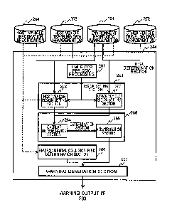
risk determination process by referring to Fig. 5. The risk
determination section 244 of the embodiment includes a timer for
periodic processing 261, a region setting section 269, a
determination section 268, an environmental collision risk
determination section 266, and a warning generation section 267.
[0066]
[Timer for Periodic Processing]
The timer for periodic processing 261 is a timer for
timekeeping. The risk determination section 244 periodically
executes a risk determination process in accordance with the
timekeeping of the timer for periodic processing 261.
[0067]
[Region Setting Section]
CA 03074570 2020-6
The risk determination section 244 in the embodiment
basically determines that the risk of collision is present when
Time To Collision (TTC: window time until collision) between the
host vehicle and another vehicle as a determination target (another
vehicle for determination) is equal to or less than a preliminarily
determined threshold value. In order to simply achieve this, the
region setting section 269 sets a collision risk determination
region (hereinafter, simply referred to as a risk determination
region) for each of the host vehicle 110 and the other vehicle for
determination. These risk determination regions are regions to
which the vehicles possibly proceed within a predetermined time,
and are regions used to determine presence/absence of the collision
risk with other vehicles.
[0068]
The region setting section 269 includes a host vehicle risk
determination region setting section (host vehicle region setting
section) 262 and another vehicle risk determination region setting
section (other vehicle region setting section) 263.
[0069]
The host vehicle region setting section 262 sets the risk
determination region of the host vehicle (host vehicle region) on
the environment information 271 using the host vehicle traveling
data, the host vehicle specification, and the environment
information 271. The host vehicle region is a region to which the
host vehicle 110 possibly proceeds within a predetermined time Ti.
26
CA 03074570 2020-6
Note that the host vehicle traveling data and the host vehicle
specification are hereinafter jointly referred to as host vehicle
information.
[0070]
As illustrated in Fig. 6A, a host vehicle region 511 is set
as a rectangular region with a position of the host vehicle 110 on
the environment information as a bottom side and the traveling
direction as a height direction. The size of the bottom side is,
for example, a width of the host vehicle 110 and the height is a
length corresponding to a vehicle speed.
[0071]
The length corresponding to the vehicle speed is calculated
using the vehicle speed and information on an actual distance
corresponding to one side of the grid like region. For example,
the number of the grid like regions corresponding to the maximum
actual distance reached in the above described predetermined time
Tl.
[0072]
Note that the shape of the host vehicle region 511 is not
limited to the rectangular region. For example, it may be a fan
shape using the traveling direction from the current position (base
point) of the host vehicle as a center line direction and having
the length corresponding to the vehicle speed as a radius.
[0073]
When a geography element (berm 120 or the like) that becomes
27
CA 03074570 2020-02-26
a barrier exists within the host vehicle region 511 set in the
above described method, the region to which the host vehicle 110
possibly proceeds is also set as a second host vehicle region along
the shape of this berm 120 or the like.
[0074]
The setting method of the host vehicle region in this case
will be described by referring to Fig. 6B. This is an example when
there is the berm 120 or the like ahead of the host vehicle 110,
and the travel route 122 curves along the berm 120 or the like.
[0075]
Even in such a case, the host vehicle region setting section
262, first, uses the width, the vehicle speed, and the traveling
direction of the host vehicle 110 and sets the host vehicle region
511 in a method similar to the example in Fig. 6A.
[0076]
At this time, when a berm region 521 corresponding to the
beLm 120 or the like exists within the host vehicle region 511, the
host vehicle 110 is highly likely to proceed along this berm 120 or
the like. In view of this, the traveling direction is changed
along the berm 120 or the like, and approximately the same sized
region of the host vehicle region as a sum of a region overlapping
with the berm 120 or the like and a region ahead with respect to
the berm 120 or the like is set in the traveling direction changed
as a second host vehicle region 512.
28
CA 03074570 2020-02-26
[0077]
The specific setting method is as follows. First, the
rectangular width region is set as the host vehicle region toward
the traveling direction 411 in order from the current host vehicle
110 position. When a part of one end in the width direction of the
host vehicle region overlaps with a region corresponding to the
berm 120 or the like (berm region; obstacle region), the region is
shifted to an opposite side of the berm region by an amount of the
width overlapped with the berm region, and, from this state, the
obtainment of the region is continued in the traveling direction
411. When all the regions in the width direction of the host
vehicle region overlap with the berm region, the traveling
direction is squarely changed in the opposite direction of the one
end that overlaps with the berm region previously, and the setting
of the region is continued.
[0078]
In the case of Fig. 6B, at the point where the host vehicle
region is set for five grid regions (squares) in the traveling
direction 411, one square on the left end overlaps with the berm
region 521. Therefore, the host vehicle region is shifted by one
square to the right side, and the region is continuously set with
the width of four squares (512a, 512b). At the point where the
host vehicle region is set for two more squares in the traveling
direction, all the regions in the width direction overlap with the
berm region 521. Here, the left side already overlaps with the
29
CA 03074570 2020-6
berm region 521. In view of this, the traveling direction 411a is
changed by 90 degrees rightward in the drawing to set the second
host vehicle region 512 with the width of four squares.
[0079]
In this case, both the second host vehicle region 512
corrected considering the berm region 521 and the host vehicle
region 511 first set are output as the host vehicle region of the
host vehicle 110.
[0080]
The other vehicle region setting section 263 sets the risk
determination regions of other vehicles (other vehicle regions) on
the environment information 271 using the environment information
271 and the other vehicle traveling information 272. A setting
method and shapes of the other vehicle regions are basically
similar to the setting method and the shape of the host vehicle
region. However, the other vehicle regions use the positions of
the other vehicles on the environment information 271 as the bottom
side.
[0081]
Furthermore, when there is the berm 120 or the like that has
the clearance 121 along the other vehicle region, the other vehicle
region setting section 263 jointly sets the other vehicle region
when traveling through this clearance 121, in addition to the other
vehicle region that is set in the ordinary method. The details
will be described later.
CA 03074570 2020-02-26
[0082]
Note that, in the embodiment, the region setting section 269
holds the information of the host vehicle region and the other
vehicle region set in the environment information 271, such as the
coordinates of each of apexes of the respective regions in the
temporary storage region 250.
[0083]
[Determination Section]
The determination section 268 is a with-vehicle collision
risk determination section that determines presence or absence of
the collision risks between the host vehicle 110 and other vehicles.
In this embodiment, presence or absence of the collision risk is
determined for each vehicle whose other vehicle traveling
information is detected by the environment recognition device 113.
When the determination result results that the collision risk is
present, an alert signal (other vehicle risk signal) meaning that
the collision risk with another vehicle is present is output to the
warning generation section 267.
[0084]
The determination section 268 determines the collision risk
between the host vehicle 110 and another vehicle for determination
based on an overlapping state of the host vehicle region set by the
host vehicle region setting section 262 and another vehicle region
of the other vehicle for determination set by the other vehicle
region setting section 263, the host vehicle information, and the
31
CA 03074570 2020-6
environment information 271. In order to achieve this, the
determination section 268 includes an overlap determination section
264 and a redetermination section 265.
[0085]
The overlap determination section 264, for example,
determines presence or absence of overlaps between the host vehicle
region and the other vehicle region of the other vehicle for
determination. The determination section 268 basically determines
that the collision risk is present when the overlap determination
section 264 determines that the overlap is present.
[0086]
For example, when the host vehicle region 511 and another
vehicle region 531 of another vehicle for determination are set as
illustrated in Fig. 7A, the overlap determination section 264
determines that the overlap is present. Meanwhile, when it is set
as illustrated in Fig. 7B, it is determined that no overlap is
present.
[0087]
The redetermination section 265 redetermines presence or
absence of the collision risk based on the host vehicle information
and the environment information 271. For example, when the host
vehicle region 511 and the other vehicle region 531 overlap, when
the berm 120 or the like exists between the host vehicle 110 and
the other vehicle for determination, it is redetermined that no
collision risk is present. That is, as illustrated in Fig. 8A,
32
CA 03074570 2020-6
when, on the environment information 271, the berm region 521
exists between the origin 0 and the other vehicle for determination
position on the environment information 271, it is redetermined
that no collision risk is present.
[0088]
At this time, the redetermination section 265 may redetermine
presence or absence of the collision risk using the diameter of the
wheel 110w of the host vehicle 110 and the vehicle speed of the
host vehicle 110. Furthermore, when the berm 120 or the like has
the clearance 121, presence or absence of the collision risk may be
redetermined using the other vehicle traveling information. That
is, when the clearance 121 of the berm 120 or the like exists ahead
in traveling of the host vehicle 110, the collision risk may be
determined considering possibilities that other vehicles coming in
from the clearance 121.
[0089]
For example, even if the host vehicle region and the other
vehicle region of the other vehicle for determination overlap and
the berm 120 or the like exists between the host vehicle 110 and
the other vehicle for determination, the redetermination section
265 determines that the collision risk is present when a height
ratio of the berm 120 or the like to the diameter of the wheel 110w
of the host vehicle 110 is less than a predetermined value. This
is because it is determined that the host vehicle 110 can go over
the berm 120 or the like.
33
CA 03074570 2020-6
[0090]
Specifically, for example, when the height of the berm 120 or
the like is less than half the height of the wheel 110w, that is,
when the above described ratio is less than 0.5, it is determined
to be able to be gone over. Conversely, when the ratio is equal to
or more than 0.5, it is determined not to be able to be gone over.
For example, when the diameter of the wheel 110w is 10 m, since all
the detected berm 120 or the like has the height of 8 m in the
example illustrated in Fig. 8B, it is considered that the risk of
the host vehicle 110 going over this berm 120 or the like is rare.
Therefore, the redetermination section 265 determines that no
collision risk is present with the other vehicle for determination
at a position with this berm 120 or the like interposed in between.
[0091]
Even if the host vehicle region and the other vehicle region
of the other vehicle for determination overlap, the berm 120 or the
like exists between the host vehicle 110 and the other vehicle for
determination, and the height ratio of the berm 120 or the like to
the diameter of the wheel 110w of the host vehicle 110 is less than
the predetermined value, the redetermination section 265 determines
that no collision risk is present when the speed of the host
vehicle 110 is less than the preliminarily determined reference
speed. In this case, it is because, even if the height of the berm
120 or the like is low compared with the diameter of the wheel 110w,
it is determined that the berm 120 cannot be gone over when the
34
CA 03074570 2020-02-26
vehicle speed is slow.
[0092]
Note that, as described above, when the other vehicle region
531 is set along a region corresponding to the berm 120 or the like
having the clearance 121 and when the width of this clearance 121
is wider than the width of the other vehicle for determination, as
illustrated in Fig. 8B, another vehicle region 532 is also set when
this clearance 121 is traveled through. Therefore, in this case,
the host vehicle region 511 and the other vehicle region 532 of the
other vehicle for determination overlap.
[0093]
In the case of the state illustrated in Fig. 8B, both the
regions overlap, but the beLm 120 or the like exists between the
host vehicle 110 and the other vehicle for determination. However,
the clearance 121 equal to or more than the width of the other
vehicle for determination exists in the berm 120 or the like. In
such a case, the redetermination section 265 determines that the
collision risk is present. Note that, as described above, the
clearance 121 is a region that is comparable with the travel route
122 and has an altitude on which the vehicle can pass through.
Therefore, for example, when the region corresponding to the
clearance 121 (clearance region) is in contact with the other
vehicle region 532, and the width of this clearance region is equal
to or more than the width of the other vehicle for determination,
the redetermination section 265 determines that the clearance 121
CA 03074570 2020-6
is present to determine that the collision risk is present.
[0094]
Meanwhile, when the width of this clearance 121 is smaller
than the width of the other vehicle for determination, the other
vehicle region 532 is not set. Therefore, in this case, the host
vehicle region 511 and the other vehicle region 531 do not overlap.
In view of this, the determination section 268 determines that no
collision risk is present.
[0095]
Note that the determination section 268 determines presence
or absence of the collision risk for each of the other vehicle for
determination. Therefore, the above described other vehicle risk
signal may include information to identify the other vehicle for
determination that is determined to have the collision risk.
[0096]
[Environmental Collision Risk Determination Section]
The environmental collision risk determination section 266
determines presence or absence of the collision risk of the host
vehicle 110 and the berm 120 or the like using the host vehicle
information and the environment information 271. When it is
determined that the collision risk with the berm 120 or the like is
present, a berm risk signal is output as the alert signal to the
warning generation section 267.
[0097]
Specifically, the environmental collision risk determination
36
CA 03074570 2020-02-26
section 266 determines that the collision risk is present when
there is the berm 120 or the like having a height equal to or more
than a first threshold value preliminarily determined in the
traveling direction of the host vehicle, and the TTC is equal to or
less than a second threshold value preliminarily determined.
[0098]
The first threshold value is a value with which it is
determinable whether the host vehicle 110 can go over this berm 120
or not. For example, 0.5 times of the diameter of the wheel 110w
of the host vehicle 110. In this case, when the height of the berm
120 or the like is smaller than the half of the diameter of the
wheel 110w of the host vehicle 110, it is possible to go over, and
it is determined that the collision risk is present. The second
threshold value is, for example, determined by the speed and the
like of the host vehicle.
[0099]
[Warning Generation Section]
The warning generation section 267 generates warning data
every time the alert signal is received from the deteLmination
section 268 and the environmental collision risk determination
section 266, and outputs the warning data to the warning output I/F
203.
[0100]
In this embodiment, for example, stylized messages are
preliminarily held in the ROM 224 or the like by being associated
37
CA 03074570 2020-6
with each of the other vehicle risk signal and the berm risk signal.
When each of the alert signals are received, the warning generation
section 267 extracts the corresponding stylized message and outputs
the stylized message as the warning data.
[0101]
Here, a description will be given of examples of the warning
output to the warning device 111 that has received the warning data.
Here, the warning device 111 is a display, and the case where a
warning screen including a message is output as the warning is
exemplarily illustrated.
[0102]
Fig. 9A is an example of a display screen 310a output as the
warning screen on the warning device 111 by the warning data
generated when the other vehicle risk signal is received. When the
other vehicle risk signal is received from the determination
section 268, the warning generation section 267 generates the
warning data using a message 314 preliminarily prepared by being
associated with the other vehicle risk signal. The warning data is,
for example, the message 314 and the like as "beware of collision
with light vehicle" as illustrated in this drawing.
[0103]
Note that when the other vehicle risk signal includes the
environment information and the other vehicle traveling information,
the warning generation section 267 may generate the warning data
such that an icon 311 indicative of the host vehicle 110, an icon
38
CA 03074570 2020-02-26
313 indicative of the other vehicle for determination, and a
graphic 312 indicative of a detected geography (such as the berm
120 or the like) are displayed as illustrated in Fig. 9A, not only
the message 314.
[0104]
Note that, as described above, the determination section 268
and the environmental collision risk determination section 266
receive the environment information 271 at predetermined time
intervals, determine presence or absence of the collision risk, and
only when it is determined that the collision risk is present,
output the warning signal to the warning generation section 267.
Therefore, the warning generation section 267 does not generate the
warning data when the alert signal is not received for the
predetermined time interval or more.
[0105]
However, even if the warning data is not generated, only the
display data of the environment information and the other vehicle
traveling information may be continuously generated to be output to
the warning device 111. In this case, as illustrated in Fig. 9B,
on the display of the warning device 111, only a display by this
display data is made as a display screen 310b.
[0106]
[Risk Determination Process]
Next, a procedure of the risk determination process by the
risk determination section 244 will be described by referring to
39
CA 03074570 2020-02-26
Fig. 10. The risk determination section 244 periodically executes
the risk determination process.
[0107]
First, a time count is started with the timer for periodic
processing 261 (Step S1001).
[0108]
The host vehicle region setting section 262 obtains the
environment information 271 from the environment information
management DB 251 (Step S1002).
[0109]
Next, the host vehicle region setting section 262 obtains the
host vehicle traveling data from the host vehicle traveling data
management DB 253 and the host vehicle specification from the host
vehicle specification 254 as the respective pieces of the host
vehicle information (Step S1003).
[0110]
The host vehicle region setting section 262 sets the host
vehicle region on the environment information 271 obtained at Step
S1002 using the obtained host vehicle information (Step S1004). At
this time, when the berm 120 or the like does not exist ahead, for
example, the host vehicle region 511 illustrated in Fig. 6A is set.
On the other hand, when the berm 120 or the like exists ahead, the
host vehicle region 511 and the second host vehicle region 512
illustrated in Fig. 6B are set.
CA 03074570 2020-02-26
[0111]
Next, the other vehicle region setting section 263 obtains
the other vehicle traveling information 272 from the other vehicle
traveling data management DB 252 (Step S1005). At this point, the
number of the vehicles registered in the other vehicle traveling
data management DB 252 is confirmed (Step S1006). Note that, here,
the recorded number of the other vehicle traveling information 272
registered in the other vehicle traveling data management DB 252 is
the number of the vehicles.
[0112]
When there is no other vehicle at Step S1006, the procedure
proceeds to Step S1014 described later.
[0113]
When there exists even one other vehicle at Step S1006, the
other vehicle region setting section 263 repeats the following
process on each of the registered other vehicles (Step S1007).
[0114]
First, the other vehicle region 531 is set on the environment
information 271 for the other vehicle for determination (Step
S1008). At this time, even for the other vehicle, when the berm
120 or the like are present, the other vehicle region 531 along the
berm 120 or the like as described in Fig. 6B is also set. When
there is the clearance 121 in the berm 120, the other vehicle
region 532 when there is the clearance 121 described in Fig. 8B is
set together for the other vehicle.
41
CA 03074570 2020-6
[0115]
The overlap determination section 264 determines whether the
set other vehicle region 531 overlaps with the host vehicle region
511 or not (Step S1009). Here, as illustrated in Fig. 7B, when
there is no overlap, the procedure proceeds to Step S1013 described
below.
[0116]
On the other hand, when there is an overlap, the
redetermination section 265 determines whether there is the berm
120 or the like between the host vehicle 110 and the other vehicle
for determination or not (Step S1010). Here, it is determined
whether there is data of altitude larger than 0 on the environment
information 271 or not.
[0117]
As illustrated in Fig. 7A, when there is no berm 120 or the
like, the redetermination section 265 determines that the collision
risk is present, and the procedure proceeds to Step S1012 described
later.
[0118]
When there is the berm 120 or the like, the
redetermination section 265 determines whether it is possible for
the host vehicle 110 to go over this berm or the like or not with
the above described method using the information, such as the
vehicle speed of the host vehicle 110 and the diameter of the wheel
110w and the height of the berm 120 or the like in between to
42
CA 03074570 2020-02-26
determine presence or absence of the collision risk (Step S1011).
[0119]
At Step S1011 and Step S1010, when the redetermination
section 265 determines that the collision risk is present, the
determination section 268 sets the other vehicle risk signal as the
alert signal (Step S1012).
[0120]
Note that, when it is determined that no collision risk is
present at Step S1011, the procedure proceeds to Step S1013
described below.
[0121]
The determination section 268 repeats the process of Step
S1007 to S1012 for all the other vehicles detected at Step S1006
(Step S1013).
[0122]
When the above described process is finished for all the
other vehicles, the environmental collision risk determination
section 266 determines the collision possibility between the host
vehicle 110 and the berm 120 or the like. Specifically, the
following process is performed.
[0123]
First, it is determined whether there is the berm 120 or the
like within the host vehicle region or not (Step S1014).
[0124]
When there is the berm 120 or the like, the environmental
43
CA 03074570 2020-02-26
collision risk determination section 266 determines the collision
risk between the berm 120 or the like and the host vehicle 110 with
the above described method using the height of the berm 120 or the
like and the size of the wheel 110w and the vehicle speed of the
host vehicle 110 (Step S1015).
[0125]
When it is determined that the collision risk is present, the
berm risk signal is set as the alert signal (Step S1016).
[0126]
On the other hand, when it is determined that no berm 120 or
the like is present at Step S1014, or when it is determined that no
collision risk is present at S1015, the procedure proceeds to S1017
described below.
[0127]
The warning generation section 267 determines whether the
alert signal is set or not (Step S1017), and when the alert signal
is set, the warning data corresponding to this alert signal is
generated. The generated warning data is output to the warning
device 111 via the warning output I/F 203 (Step S1018). On the
other hand, when it is not set, the process is terminated in this
state.
[0128]
As described above, the safe driving assistance device 112 of
the embodiment includes the region setting section 269, the
determination section 268, and the warning section (the warning
44
CA 03074570 2020-02-26
generation section 267 and the warning device 111). The region
setting section 269 sets a risk determination region of a vehicle
on environment data using travel data including a current position,
a traveling direction, and a speed of the vehicle, a vehicle
specification including a size of the vehicle, and the environment
data including altitudes of a geography. The determination section
268 determines presence or absence of a collision risk between a
host vehicle and another vehicle for determination using a host
vehicle region as the risk determination region of the host vehicle
110, another vehicle region as the risk determination region of the
other vehicle for determination as a determination target other
vehicle, and the environment data. The warning section outputs a
warning when the determination section determines that the
collision risk is present.
[0129]
Thus, the embodiment uses, not only the relative distance and
the TTC between the vehicles, but the environment information of
the berm 120 or the like detected by the environment recognition
device 113, for determining the collision risk. In view of this,
even in a condition where it is determined that the collision risk
is present by using only the relative distance and the TTC, it is
determined that no collision risk is present under a predetermined
condition. For example, it is when there is the berm 120 or the
like of a sufficient height between the host vehicle 110 and the
other vehicle for determination. Therefore, the embodiment ensures
CA 03074570 2020-02-26
determining presence or absence of the collision risk with further
high accuracy. Accordingly, an unnecessary warning can be reduced.
[0130]
In determining presence or absence of the collision risk, the
embodiment may consider, not only the height of the berm 120 or the
like, but a vehicle speed, a diameter of the wheel 110w, and the
like of the host vehicle 110. Presence or absence of the clearance
121 of the berm 120 or the like may also be considered.
Considering these conditions ensures determining presence or
absence of collision with even high accuracy. Therefore, the
unnecessary warning can be further reduced.
[0131]
Thus, the embodiment reduces an unnecessary warning output
for an operator. Therefore, the reliability of the output warning
is enhanced.
[0132]
In particular, a heavy haulage vehicle, such as a dump truck,
is used in a mine, a construction site, and the like. Happenings
of, for example, a collision accident of a heavy haulage vehicle
with a light vehicle conveying luggage and personnel, a collision
accident between heavy haulage vehicles, and a single car accident,
such as falling, largely affect an execution of operation due to
the halt of a mining operation in a mine or a construction work in
a construction site in addition to a direct damage from the
accident. Therefore, it is important to surely preventing the
46
CA 03074570 2020-02-26
collision accident and the single car accident. Meanwhile,
unnecessarily and frequently issuing the warning lowers the
reliability of the warning. With the embodiment, since the
necessity of the warning is determined by considering whether the
collision risk is eliminated by the safety facility, such as the
berm, between the host vehicle and other vehicles even in such an
environment, it is possible to give a necessary and sufficient
warning to ensure obtaining high reliability in the warning.
[0133]
<<Second Embodiment>>
Next, a second embodiment of the present invention will be
described. In this embodiment, a vehicle-to-vehicle communication
is used for detecting means of other vehicles.
[0134]
The safe driving assistance system 100 of the embodiment
basically has a configuration similar to that of the first
embodiment. The following describes the embodiment focusing on the
configuration different from that of the first embodiment.
[0135]
Fig. 11 is a drawing for describing a usage environment of a
safe driving assistance system 100a of the embodiment.
[0136]
The safe driving assistance system 100a of the embodiment is
assumed to be used in a mine, similarly to the first embodiment.
That is, the safe driving assistance system 100a is mounted on the
47
CA 03074570 2020-6
large sized heavy machine vehicle 110, such as a dump truck and an
excavator, that operates in the mine. However, in the embodiment,
each vehicle mutually exchanges and detects each other's location
information by a vehicle-to-vehicle communication 601.
[0137]
A function block of the safe driving assistance system 100a
of the embodiment is illustrated in Fig. 2B. As illustrated in the
drawing, the safe driving assistance system 100a of the embodiment
basically has a configuration similar to that of the first
embodiment. That is, the warning device 111, the environment
recognition device 113, the steering angle sensor 114, and the
vehicle speed sensor 115 are included. However, a safe driving
assistance device 112a is included instead of the safe driving
assistance device 112. The safe driving assistance system 100a of
the embodiment includes a vehicle-to-vehicle communication device
116 and a position detecting device 117.
[0138]
The position detecting device 117 obtains the position
information of a vehicle on which this position detecting device
117 is mounted. The position information is obtained using, for
example, a Global Navigation Satellite System (GNSS) that is a
positioning system using a radio wave of a navigation satellite,
such as a Global Positioning System (GPS) satellite. In this case,
for example, the position information is obtained by latitude,
longitude, and the like. Note that a reference point may be
48
CA 03074570 2020-02-26
disposed in a mine and relative distances from there may be
obtained as the position information.
[0139]
The vehicle-to-vehicle communication device 116 receives
position information data from each of other vehicles. The
received position information data includes information to identify
the other vehicles of the transmission origins (vehicle
identification information) and position information of the other
vehicles.
[0140]
Note that, in the embodiment, each vehicle includes the
position detecting device 117 and the vehicle-to-vehicle
communication device 116. The position information of the vehicle
obtained by the position detecting device 117 is mutually exchanged
with the vehicle-to-vehicle communication via the vehicle-to-
vehicle communication device 116 to detect the other vehicles.
Other system configuration is similar to that of the first
embodiment.
[0141]
The safe driving assistance device 112a of the embodiment
basically has a configuration similar to that of the first
embodiment. However, as illustrated in Fig. 12, the safe driving
assistance device 112a of the embodiment obtains the information on
other vehicles with the vehicle-to-vehicle communication. In view
of this, a vehicle-to-vehicle communication I/F 204 is further
49
CA 03074570 2020-6
included.
[0142]
The vehicle-to-vehicle communication I/F 204 is an interface
with the vehicle-to-vehicle communication device 116. From the
vehicle-to-vehicle communication device 116, the other vehicle
traveling information of other vehicles is obtained.
[0143]
The other vehicle traveling information recognition section
242 receives the other vehicle traveling information from the
environment information obtaining I/F 201 in the first embodiment.
However, in this embodiment, the other vehicle traveling
information is received from the vehicle-to-vehicle communication
I/F 204.
[0144]
Note that the other vehicle traveling information received
via the vehicle-to-vehicle communication I/F 204 is a value of the
coordinate system employed by the position detecting device 117 as
described above. Therefore, the other vehicle traveling
information recognition section 242 of the embodiment converts a
value depending on the coordinate system, such as the position
information and the traveling direction, among the other vehicle
traveling information into a value of a local coordinate system to
register the value in the other vehicle traveling data management
DB 252.
CA 03074570 2020-6
[0145]
At this time, the vehicle identification information obtained
with the vehicle-to-vehicle communication is stored as the
identifier 421. The speed and the traveling direction are
calculated from the position information 422 of the other vehicle.
On the other hand, the width 427, the length 428, and the type of
vehicle 429 are obtained from information preliminarily held for
the types of vehicles that possibly travel in the mine, similarly
to the first embodiment. Note that these pieces of information may
be held being associated with the vehicle identification
information.
[0146]
The host vehicle traveling data recognition section 243
periodically transmits the host vehicle traveling data managed by
the host vehicle traveling data management DB 253 to other vehicles
via the vehicle-to-vehicle communication I/F 204 in addition to the
function of the above described first embodiment.
[0147]
Note that, the risk determination method and the like of the
embodiment is basically similar to that of the first embodiment.
In view of this, it is similar to the first embodiment, thereby
omitting the explanation.
[0148]
As described above, the safe driving assistance device 112 of
the embodiment includes the region setting section 269, the
51
CA 03074570 2020-02-26
determination section 268, and the warning section (the warning
generation section 267 and the warning device 111). The region
setting section 269 sets a risk determination region of a vehicle
on environment data using travel data including a current position,
a traveling direction, and a speed of the vehicle, a vehicle
specification including a size of the vehicle, and the environment
data including altitudes of a geography. The determination section
268 determines presence or absence of a collision risk between a
host vehicle and another vehicle for determination using a host
vehicle region as the risk determination region of the host vehicle
110, another vehicle region as the risk determination region of the
other vehicle for determination as a determination target other
vehicle, and the environment data. The warning section outputs a
warning when the determination section determines that the
collision risk is present. The other vehicle travel data is
obtained with a vehicle-to-vehicle communication.
[0149]
The embodiment ensures reducing generation of warning in
consideration of the obstacles, such as the berm 120 or the like
between the host vehicle 110 and the other vehicle for
determination, similarly to the first embodiment. In view of this,
the warning can be output with further high accuracy, similarly to
the first embodiment.
[0150]
Furthermore, in this embodiment, the position information
52
CA 03074570 2020-6
among the other vehicle information is obtained with the vehicle-
to-vehicle communication. In view of this, the position
information of other vehicles can be obtained with further high
accuracy. Therefore, the warning can be output with further high
accuracy.
[0151]
<Modification>
Note that, while in the above described embodiments, the risk
determination section 244 determines presence or absence of the
collision risk, it is not limited to this. For example, it may be
configured to provide a plurality of levels for the collision risk
and determine the level (warning level). In this case, the risk
determination section 244 generates warning data corresponding to
the warning level and output the warning data to the warning device
111.
[0152]
The warning level is, for example, preliminarily determined
corresponding to a condition of the host vehicle 110, the other
vehicle for determination, and the environment information.
[0153]
For example, the respective different warning levels are
preset to each state, such as a first state in which no overlap is
present between the host vehicle region 511 and the other vehicle
region 531 as illustrated in Fig. 7A, a second state in which an
overlap between the host vehicle region 511 and the other vehicle
53
CA 03074570 2020-02-26
region 531 is present, but the berm 120 or the like is present in
between as illustrated in Fig. 8A, a third state in which no
overlap is present between the host vehicle region 511 and the
other vehicle region 531, but the clearance 121 is present in
between as illustrated in Fig. 83, and a fourth state in which the
host vehicle region 511 and the other vehicle region 531 overlap,
but no berm 120 or the like is present in between as illustrated in
Fig. 7B.
[0154]
A plurality of phases of warning levels may be further set
into the above described second state, in relation with the vehicle
speed, the diameter of the wheel, and the height of the obstacle.
[0155]
When the warning level is thus set for each state, the
determination section 268 outputs the other vehicle risk signal
corresponding to the warning level to the warning generation
section 267. The warning generation section 267 generates the
warning data having a warning degree corresponding to the warning
level. The generated warning data is, for example, preliminarily
held in the ROM 224 or the like for each level.
[0156]
Note that the present invention is not limited to the above
described embodiments, but various modifications are included. For
example, the above described embodiments are described in details
in order to describe the present invention to be easily understood,
54
CA 03074570 2020-02-26
and are not necessarily limited to include all the described
configurations.
LIST OF REFERENCE SIGNS
[0157]
100 safe driving assistance system
100a safe driving assistance system
110 large sized heavy machine vehicle (host vehicle)
110w wheel
111 warning device
112 safe driving assistance device
112a safe driving assistance device
113 environment recognition device
114 steering angle sensor
115 vehicle speed sensor
116 vehicle-to-vehicle communication device
117 position detecting device
120 berm
121 clearance
122 travel route
130 large sized heavy machine vehicle
140 general vehicle
140a general vehicle
140b general vehicle
201 environment information obtaining I/F
CA 03074570 2020-6
202 traveling data obtaining I/F
203 warning output I/F
204 vehicle-to-vehicle communication I/F
221 CPU
222 RAM
223 FLASH memory
224 ROM
225 I/F
230 safe driving assistance program
231 environment information recognition program
232 other vehicle traveling information recognition program
233 host vehicle traveling data recognition program
234 risk determination program
240 region for safe driving assistance program
241 environment information recognition section
242 other vehicle traveling information recognition section
243 host vehicle traveling data recognition section
244 risk determination section
250 temporary storage region
251 environment information management DB
252 other vehicle traveling data management DB
253 host vehicle traveling data management DB
254 host vehicle specification
261 timer for periodic processing
262 host vehicle region setting section
56
CA 03074570 2020-6
263 other vehicle region setting section
264 overlap determination section
265 redetermination section
266 environmental collision risk determination section
267 warning generation section
268 determination section
269 region setting section
271 environment information
272 other vehicle traveling information
310a display screen
310b display screen
311 icon
312 graphic
313 icon
314 message
411 traveling direction
411a traveling direction
412 grid region
413 grid region
414 grid region
421 identifier
422 position information
425 speed
426 traveling direction
429 type of vehicle
57
CA 03074570 2020-02-26
430 registered time
511 host vehicle region
512 second host vehicle region
521 berm region
531 other vehicle region
532 other vehicle region
601 vehicle-to-vehicle communication
58