Note : Les descriptions sont présentées dans la langue officielle dans laquelle elles ont été soumises.
CA 03078254 2020-04-02
WO 2019/068188
PCT/CA2018/051246
METHOD AND SYSTEM FOR TRACKING, PROCESSING, AND
INTEGRATING AIRPORT GROUND VEHICLE POSITION DATA INTO THE
AUTOMATIC DEPENDENT SURVEILLANCE ¨ BROADCAST (ADS-B)
NETWORK INFRASTRUCTURE
FIELD
[0001] This invention relates to a ground vehicle tracking and reporting
system,
and in particular to airport surface management, that is compatible with and
integrates with
Automatic Dependent Surveillance-Broadcast (ADS-B) network.
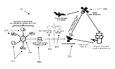
BACKGROUND
[0002] Airports are complex operating environments with vehicular
traffic
comprised of aircraft, and the ground vehicles (e.g., service, food,
passenger, luggage, etc.)
necessary to support and service the airport and aircraft. Every year, there
are incidents
and accidents involving aircraft and vehicles at airports that have
potentially serious
consequences. For example, runway incursions are incidents where an
unauthorized
aircraft, vehicle, or person is on a portion of the airport designated as a
movement area
(e.g. runway, taxiway). This presence creates a safety risk that an airplane
taking off or
landing will collide with the object. Many of these events occur in periods of
reduced
visibility (e.g. fog), which can result in a loss of situational awareness for
flight crews, air
traffic controllers and support personnel working on the airfield.
[0003] Additionally, it is important that different service departments
that operate
within the airport (e.g. baggage handlers, security, maintenance, ground
crews) are able to
track the movement of and locate their vehicles. Fleet management can include
a range of
functions, such as vehicle maintenance, vehicle telematics (e.g. diagnostics,
tracking),
driver management, fuel management, and health & safety management. Proper
fleet
management can minimize the risks associated with vehicle investment, improve
productivity and efficiency, and ensure the safety of the vehicle and other
assets near the
vehicle.
[0004] For at least the above reasons, it is important to be able to
track the locations
of vehicles, airplanes, and other assets at an airport. Historically, Surface
Movement Radar
(SMR) has been used to try and track these locations. SMR detects aircraft and
ground
vehicles on the surface of an airport. SMR uses a rotating antenna, often
mounted on an
airport tower, to scan the area of the airport within range of the antenna.
When SMR senses
1
CA 03078254 2020-04-02
WO 2019/068188
PCT/CA2018/051246
an object the SMR returns a return pulse or 'blip' that identifies the
location of an object(s)
on the airport surface, but the return pulse is insufficient to identify the
object by type,
name, function, or intention. For example, SMR can identify that there is "an"
object on
the airport surface, but provides insufficient detail to determine if the
object is an aircraft
or a ground vehicle, much less if it is supposed to be there or not. SMR is
therefore
typically augmented by visual observation or other data sources and can be
overlaid on a
map view of the airport to provide context and meaning to the SMR 'blip.'
[0005] One type of additional data source is an Automatic Dependent
Surveillance
¨ Broadcast (ADS¨B) system. The ADS-B system is a surveillance system where an
aircraft or ground vehicle determines its own position via navigation
technology and
periodically broadcasts it. The ADS-B system is "automatic" because it does
not rely on a
pilot or external output to broadcast or determine its position. The ADS-B
system is
"dependent" on the aircraft's navigation technology. This navigation
technology can
include radio navigation or GPS navigation techniques. This information is
used to inform
other aircraft and ground stations about location, speed (both horizontally
and vertically),
and intention.
[0006] The ADS-B system generally comprises three main components:
ground
infrastructure, a transmitting structure, and operating procedures. The ground
infrastructure can comprise ADS-B antennas on the ground, a network
infrastructure to
transmit received messages to relevant air traffic controllers (ATC), and
systems to fuse
the surveillance data from ADS-B with surveillance data from existing RADAR
infrastructure. The ground infrastructure can include further structural units
and/or
programming to transmit and receive surveillance data as necessary. The
transmitting
structure functions at the source (e.g. a vehicle or aircraft, and includes
message generation
and transmission functions). The transmitting structure can comprise a
dedicated 978 MHz
universal access transceiver (UAT), a 1090 MHz Mode S "extended squitter"
transponder
paired with a GPS navigation source, or any structure that functions as
necessary. An ADS-
B datalink supports a number of airborne and ground applications. Each
application has
its own operational concepts, algorithms, procedures, standards, and user
training.
[0007] For example, an aircraft with an "ADS-B Out" transmitter
periodically
broadcasts information about the aircraft, such as identification, its
position in space, air
speed, altitude, and air-maneuver information via the datalink. An "ADS-B In"
receiver
receives and interprets ADS-B data on a computer screen. "ADS-B In" receivers
can be
2
CA 03078254 2020-04-02
WO 2019/068188
PCT/CA2018/051246
integrated into the air traffic control system or installed aboard other
aircraft to provide an
accurate depiction of real-time aviation traffic, both in the air and on the
ground.
[0008] ADS-B is becoming one of the most important technologies for air
transportation, but the technology was originally designed for aircraft, and,
although it can
now also be used in many ground vehicles it does not, on a standalone basis,
efficiently
solve the location tracking challenges associated with airport ground vehicles
and mobile
equipment.
[0009] To improve the efficiency and effectiveness of airport surface
movement
management, it is desirable to have ADS-B tracking data for airport ground
vehicles and
mobile equipment. However, it is cost prohibitive to install individual ADS-B
transponders on tens, and in larger airports hundreds, of ground vehicles and
assets for
which ADS-B was not designed. Additionally, as noted by the Federal Aviation
Administration (FAA), Airport Surface Detection Equipment-Model X (ASDE-X) and
Airport Surface Surveillance Capacity (ASSC) are needed to receive the ADS-B
squitter
signals from the ground vehicles for use on ATC displays. A limited number of
airports
have been outfitted with these capabilities.
[0010] The present invention provides a method and system for tracking
airport
ground vehicles and equipment that can be integrated with the ADS-B ground
infrastructure for reporting purposes. The present invention may be beneficial
because it
does not require installing individual ADS-B transponders on the ground
vehicles/assets
themselves.
SUMMARY
[0011] In accordance with one aspect of the present invention, there is
provided a
method for tracking, processing and integrating data from a plurality of
vehicles in an
airport environment. The method including steps of: collecting data from the
plurality of
vehicles, wherein the data includes positional data of each of the plurality
of vehicles;
combining the data from each of the plurality of vehicles into a combined data
stream
having an ADS-B data format; and transmitting the combined data stream to an
ADS-B
network.
BRIEF DESCRIPTION OF THE DRAWINGS
[0012] FIG. 1 shows an embodiment of a portions of system according to
the
present invention; and
3
CA 03078254 2020-04-02
WO 2019/068188
PCT/CA2018/051246
[0013] FIG. 2 shows an embodiment of portions of a method according to
the
present invention.
DETAILED DESCRIPTION
[0014] The method and system disclosed herein determines the identity
of, tracks,
and transmits the location of individual airport ground vehicles and assets.
The method
and system 10 includes a link between a Local Airport Surface Network 100 and
a Global
ADS-B Network 200. The Local Airport Surface Network 100 can comprise tracked
assets
or vehicles 110 via a base receiver 150 further described below. The Global
ADS-B
Network 200 can comprise an ADS-B satellite network and an ADS-B ground-based
telecommunications network further described below. See FIGS. 1.
[0015] The system 10 can use any number of the commercially available
tracking
solutions available on the market or can rely on any type of specially
designed trackers. In
one embodiment, a so-called "Here I Am" tracking method or system is used
where a
tracking unit continually tracks its own location, creates a "here I am" ping,
and transmits
the ping to the base receiver 150. The tracking system is so-called "Here I
Am" because it
is the tracking unit itself that creates the ping that is sent to the base
receiver 150. In one
version, a GPS-based tracking unit mounted in a vehicle 110 is used. In
another version, a
tracking program or service on a cell phone or other cellular-equipped device
is used. In a
further version, specially designed GPS-enabled devices are used. Any type of
tracking
unit can be implemented with the present method as long as these units
continually track
and transmit the location of the asset or vehicle 110 to the base receiver
150. The location
can be transmitted to the base receiver 150 via a cellular network, Wi-Fi
network, or other
suitable network methods.
[0016] In another embodiment, an off-vehicle technology or tracking
method, e.g.,
a so-called "There You Are" tracking method or system is used where the assets
or vehicles
110 are "tagged" by an external source and a scanning device is used to sense
the presence
of and locate a "tagged" asset. The tracking system is so-called "There You
Are" because
a separate sensor determines the location of the "tagged" asset or vehicle
110, creates a
"there you are" location ping, and sends the location ping to the base
receiver 150. In one
version, a Radio Frequency Identification (RFID) tag is used to "tag" the
asset or vehicle
110. The RFID tagged asset or vehicle 110 cannot transmit its own location,
but when a
GPS-enabled device comes within range of the RFID tagged asset or vehicle 110,
the GPS-
enabled device approximates the location of the RFID tagged device and
transmits the
4
CA 03078254 2020-04-02
WO 2019/068188
PCT/CA2018/051246
location to the base receiver 150. The location can be transmitted to the base
receiver 150
via a cellular network, Wi-Fi network, or other suitable network methods. RFID
also
includes identification systems with active radio frequency (RF) transmitters.
In particular,
RFID is not limited to close-range, passive applications, but can be used
(with active,
powered RF transceivers) for identification over long ranges, on the range of
ones or tens
of miles or kilometers. Using one or more triangulation technologies, the
assets or vehicles
110, such as ground vehicles in an airport, determine their own approximate or
exact
locations. For example, the locations of the assets or vehicles 110 may be
determined
within an accuracy of various ranges, such as for example, ten meters, three
meters, one
meter, or ten centimeters.
[0017] The above two examples are presented to illustrate the concept.
It is
contemplated that any "Here I Am" tracking method, "There You Are" tracking
method,
or other suitable location tracking methods may be integrated into the present
system 10.
[0018] Whether the location of the assets or vehicles 110 are determined
using the
"Here I Am" method, the "There You Are" method, or any other suitable tracking
method
the method and system disclosed herein involves each asset or vehicle 110 on
an airport
surface individually transmitting its information to the base receiver 150
using an on-
vehicle communication system such as radio, cell, wi-fl or other
communication. In one
embodiment the base receiver 150 is known as a Local Surface Receiver (LSR).
This
information can include, for example: the vehicle's location, the vehicle's
identification
tag, the current operator of the vehicle 110 , the current diagnostics of the
vehicle 110,
and/or other desired information. The base receiver 150 is configured to
collect and locally
store this information. In one embodiment, a single base receiver is used for
the airport. In
another embodiment, multiple base receivers 150 are situated throughout the
airport. A
single base receiver 150 can be used in situations where the airport is
smaller and more
centralized whereas multiple base receivers 150 may be used in larger
airports. In another
embodiment, a separate base receiver 150 is used for each type of tracked
asset or vehicle
110 throughout the airport. Any number of base receivers 150 and locations of
the base
receivers 150 is contemplated. The base receivers 150 may be installed at a
fixed or
movable location at or near the airport but is in any case within range of the
communication
systems of the assets or vehicles 110.
[0019] A data processor 180 is connected to the base receiver 150. In
one
embodiment, the data processor 180 is a computer identified herein as a Local
Airport
CA 03078254 2020-04-02
WO 2019/068188
PCT/CA2018/051246
Surface Processor (LASP). The data processor 180 can be connected to the base
receiver
150 via a cable network, a cellular network, a Wi-Fi network, and/or any other
suitable
connection means. In one embodiment, a single data processor 180 is connected
to a single
base receiver. 150 In another embodiment, a single data processor 180 is
connected to
multiple base receivers 150. In a yet further embodiment, multiple data
processors 180 are
connected to a single base receiver 150. Any configuration of a base receiver
150 and a
data processor 180 consistent with the desired use is contemplated.
[0020] The data processor 180 is configured to collect at least a
portion of the
individual vehicle information from the base receiver 150. In one embodiment,
the data
processor 180 only collects the location information in the base receiver 150
for each
individual asset or vehicle 110. In another embodiment, the data processor 180
collects all
the information in the base receiver 150 for each individual asset or vehicle
110. Any
amount of information consistent with the desired use is contemplated.
[0021] Referring to FIG. 2, in one embodiment, the data processor 180
may
combine the individual vehicle information, from multiple assets or vehicles
110, into a
single combined data stream. Any suitable method or means of combining the
individual
data points is contemplated. The data processor 180 then converts the combined
data
stream into a single ADS-B compatible data protocol. In another embodiment,
each one of
the separate pieces of the individual vehicle information is converted into a
separate data
packet having a compatible ADS-B data protocol. Once all the separate pieces
or data
packets are converted into ADS-B data format, the separate pieces or data
packets may be
combined into a single combined ADS-B data stream. Any means and method of
combining and converting the individual vehicle information is contemplated.
[0022] Within the boundaries of the established protocol, an ADS-B
message can
be 112 bits long and consist of five parts. The five parts comprise: a
downlink format;
capability; International Civil Aviation Organization (ICAO) vehicle address;
data/type
code; and parity/interrogator ID. The type code helps identify what
information is
contained in an ADS-B message. Type codes signifiers are as follows: 1-4
signify aircraft
identification; 5-8 signify surface position; 9-18 signify airborne position
(w/ barometric
altitude); 19 signifies airborne velocities; 20-22 signify airborne positions
(w/ global
navigation satellite system height); and 23-31 signify other uses.
[0023] During this data conversion, each asset or vehicle 110 within the
Local
Airport Surface Network is assigned a 24-bit ICAO identification and vehicle
6
CA 03078254 2020-04-02
WO 2019/068188
PCT/CA2018/051246
identification code to uniquely identify it within the Global ADS-B Network
200. In one
embodiment, the Global ADS-B Network 200 comprises an Aireon network with at
least
an Aireon Satellite Network and an Aireon ground-based Aireon Teleport
Network,
although it is contemplated that any suitable Global ADS-B Network 200 is
contemplated.
The FAA, in Advisory Circular No. 15/5220-26, has allocated a block of 200
ICAO
identification codes for assets or vehicles 110 to enforce a limit of 200
ground vehicle
ADS-B devices per airport. However, the maximum number of assets or vehicles
110 that
can be incorporated into the single ADS-B data stream of a single ADS-B device
in the
system 10 is only limited by FAA regulation on the number of ICAO
identification codes
allowable per airport. Any number of vehicles or assets 110 can be
incorporated into the
ADS-B data stream.
[0024] The data processor 180 is further connected to an ADS-B
broadcaster 250.
The data processor 180 sends the combined ADS-B data stream to the ADS-B
broadcaster
250. In one embodiment, the data processor 180 is connected to a single ADS-B
broadcaster 250 that is connected to both an ADS-B satellite network and an
ADS-B
ground-based telecommunication network. In another embodiment, the data
processor 180
is connected to a first ADS-B broadcaster 250 connected to an ADS-B satellite
network
and the data processor 180 is further connected to a second ADS-B broadcaster
250
connected to an ADS-B ground-based telecommunication network. The data
processor
180 is connected to any number of ADS-B broadcasters 250 consistent with the
desired
use. The data processor 180 is connected to the ADS-B broadcaster 250 via a
cable
network, a cellular network, a Wi-Fi network, and/or any other suitable
connection means.
[0025] The ADS-B satellite network can comprise a plurality of linked
satellites
290 in orbit around Earth connected to at least one broadcaster 250. The
satellite network
allows communications between remote stations/broadcasters 250 by "uplinking"
and
"downlinking" to at least one of the satellites 290 in the network. The ADS-B
ground-
based telecommunication network can comprise at least one ADS-B broadcast
receiver
connected to the ATC. The ADS-B broadcast receiver can comprise an antenna
connected
to the ADS-B broadcaster 250 via a cable network, a cellular network, a Wi-Fi
network,
and/or any other suitable connection means.
[0026] The ADS-B broadcaster 250 transmits or "broadcasts" the ADS-B
data
stream received from the Local Airport Surface Processor (LASP). The ADS-B
data
stream can be transmitted simultaneously to both the ADS-B satellite network
and the
7
CA 03078254 2020-04-02
WO 2019/068188
PCT/CA2018/051246
ADS-B ground-based telecommunication network. In another embodiment, the ADS-B
data stream can be sent to either the ADS-B satellite network or the ADS-B
ground-based
communication and then to the other of ADS-B satellite network or the ADS-B
ground-
based communication. Any order of transmitting the ADS-B data stream is
considered.
[0027] The purpose of transmitting the ADS-B data stream is for
disseminating the
airport vehicle positional data to airports, aircraft and other users across
the local airport
and across the globe. U.S. Patent 7,961,136 presents an example embodiment of
receiving
and processing ADS-B data. The '136 patent is hereby incorporated herein by
reference.
It is contemplated that any method of receiving and processing the ADS-B data
stream
consistent with the desired use is hereby contemplated. For example, a user at
a remote
location can connect to the ADS-B satellite network by "downlinking" at an ADS-
B
receiver. This will allow a user to monitor the converted information for an
asset or vehicle
110 at a select airport. For example, a user in New York with an ownership
interest in
certain assets or vehicles 110 at the Hartsfield-Jackson Atlanta International
airport can
monitor the location and use of their assets or vehicles 110. In another
embodiment, an
airplane can be outfitted with an "ADS-B In" receiver allowing the airplane to
access the
ADS-B satellite network and determine the location of assets or vehicles 110
at a select
airport before attempting to land at that airport. The "ADS-B In" receiver in
the airplane
enables pilots to see the asset's location on in-cockpit moving maps. It is
further
contemplated that regardless of whether the data is transmitted via an ADS-B
satellite
network and an ADS-B ground-based telecommunication network, the data
processor 180
or other computer receiving data therefrom can be configured to display the
location of
some or all of the tracked assets or vehicles 110 upon a map, either in real
time, at fixed
time intervals, or in a time-delayed manner via aggregated data. In one
example, the map
could be a detailed map of the airport that shows the location of the vehicles
or assets 110.
In another example, the map could be a geographic map of a city, country, or
world
showing the vehicles or assets 110 across a wide area.
[0028] The system and method is further configured to enable the
comparison of
information received from the base receiver 150 and other vehicle positional
data sources
to determine any inconsistencies. In an embodiment where the base receiver 150
receives
at least two discreet sources of location information for a given asset, the
data processor
180 can be further configured to compare that location information. The data
processor
180 could be configured to identify and alert to a user of any inconsistencies
between the
8
CA 03078254 2020-04-02
WO 2019/068188
PCT/CA2018/051246
location data sources. For example, if a "Here I Am" signal places the asset
or vehicle 110
at location X and a "There You Are" signal for the same time places the asset
or vehicle
110 at location Y, the data processor 180 would identify the discrepancy and
flag the asset
or vehicle 110 for further interrogation, analysis or reporting. The
comparison of positional
information from discreet sources can be done by any method or means
consistent with
the desired use.
[0029] It is further contemplated that the information in the ADS-B data
stream
can be compared to the SMR data to check for differences between the data.
Identified
anomalies may be indicative of technical problems with the trackers, security
risks, issues
in transference of the data, and/or another possible issue. In one embodiment,
the data
processor 180 also collects the SMR data and after converting the information
from the
base receiver 150 to the ADS-B data format compares the ADS-B data and the SMR
data
for inconsistencies. In another embodiment, the data processor 180 collects
the SMR data
and compares it directly to the information from the base receiver 150. In a
yet further
embodiment, a user and/or program at the ATC collects SMR data and is
connected to the
ADS-B ground-based telecommunications network to collect the ADS-B data stream
to
compare the SMR data and the ADS-B data stream. Any method of comparing the
collected data is considered that is consistent with the purpose described.
[0030] The following documents are hereby incorporated herein, in their
entirety,
by reference: "FAA-E-3032, Airport Ground Vehicle ADS-B Specification" and
"FAA
Advisory Circular, 150/5220-26, Airport Ground Vehicle Automatic Dependent
Surveillance ¨ Broadcast (ADS-B) Out Squitter Equipment."
9