Note : Les descriptions sont présentées dans la langue officielle dans laquelle elles ont été soumises.
CA 03141760 2021-11-23
WO 2020/243216 PCT/US2020/034779
INTERPRETING SEISMIC FAULTS WITH MACHINE LEARNING TECHNIQUES
Cross-Reference to Related Applications
[0001] This application claims priority to U.S. Provisional Patent Application
having serial no.
62/853,681, which was filed on May 28, 2019 and is incorporated herein by
reference in its
entirety.
Background
[0002] Interpretation of geological structures within seismic datasets can
enable the
exploration, development, and production of resources such as petroleum, among
others. In some
examples, interpreting the seismic datasets can include interpreting or
identifying fault structures
in geological formations. Due to the geological complexities in subsurface
regions and limitations
associated with seismic imaging resolution, interpretation of seismic datasets
can be inefficient,
inaccurate, and require performing a large number of repetitive tasks. For
example, manually
interpreting seismic data can be impractical because manually interpreting
seismic data is labor
intensive and time consuming, particularly with ever increasing quantities of
costly seismic
datasets.
[0003] In some examples, machine learning techniques can be used to
automate fault
interpretation from seismic data. The machine learning techniques can detect
faults along vertical
seismic sections such as inline seismic sections or crossline seismic
sections. In some
embodiments, labeled seismic data can be detected as user input. The labeled
seismic data can
train a machine learning technique, such as a deep neural network, among
others. The trained
machine learning technique can be used to detect faults on a given two-
dimensional (2D) seismic
image corresponding to inline seismic data or crossline seismic data. In some
embodiments, the
machine learning technique can then detect predicted faults for subsequent
seismic data or 2D
seismic images. In some examples, the machine learning techniques can
aggregate predicted faults
from the 2D seismic images to form predicted faults within a three-dimensional
(3D) seismic
volume. However, when using 3D seismic images versus 2D seismic images, the
results include
a high number of false positive noise and often lack coherence in 3D. For
example, machine
learning techniques can generate a high number of false positive values when
the seismic data is
noisy.
1
CA 03141760 2021-11-23
WO 2020/243216 PCT/US2020/034779
Summary
[0004] Embodiments of the disclosure provide a method for interpreting seismic
data. The
method includes receiving seismic data that represents a subterranean volume,
and generating one
or more inline probability values and one or more crossline probability values
using a first machine
learning technique. The first machine learning technique is trained to
identify one or more vertical
fault lines in a seismic volume based on the seismic data. The method also
includes generating a
merged data set by combining the one or more inline probability values and the
one or more
crossline probability values, training a second machine learning technique
based on a subset of
labeled horizontal planes from the merged data set, the second machine
learning technique trained
to identify one or more horizontal fault lines from the seismic volume, and
generating a
representation of the seismic volume based on the second machine learning
technique, the
representation including an indication of a three-dimensional fault structure
within the seismic
volume.
[0005] Embodiments of the disclosure also provide a computing system for
interpreting seismic
data. The computing system includes one or more processors, and a memory
system including
one or more non-transitory computer-readable media storing instructions that,
when executed by
at least one of the one or more processors, cause the computing system to
perform operations. The
operations include receiving seismic data that represents a subterranean
volume, and generating
one or more inline probability values and one or more crossline probability
values using a first
machine learning technique. The first machine learning technique is trained to
identify one or
more vertical fault lines in a seismic volume based on the seismic data. The
operations also include
generating a merged data set by combining the one or more inline probability
values and the one
or more crossline probability values, training a second machine learning
technique based on a
subset of labeled horizontal planes from the merged data set, the second
machine learning
technique trained to identify one or more horizontal fault lines from the
seismic volume, and
generating a representation of the seismic volume based on the second machine
learning technique,
the representation including an indication of a three-dimensional fault
structure within the seismic
volume.
[0006] Embodiments of the disclosure further provide at least one non-
transitory computer-
readable medium for interpreting seismic data, the at least one computer-
readable medium
2
CA 03141760 2021-11-23
WO 2020/243216 PCT/US2020/034779
comprising a plurality of computer-executable instructions that, in response
to execution by a
processor, cause the processor to receive seismic data that represents a
subterranean volume, and
generate one or more inline probability values and one or more crossline
probability values using
a first machine learning technique. The first machine learning technique is
trained to identify one
or more vertical fault lines in a seismic volume based on the seismic data.
The instructions further
cause the processor to generate a merged data set by combining the one or more
inline probability
values and the one or more crossline probability values, train a second
machine learning technique
based on a subset of labeled horizontal planes from the merged data set, the
second machine
learning technique trained to identify one or more horizontal fault lines from
the seismic volume,
and generate a representation of the seismic volume based on the second
machine learning
technique, the representation including an indication of a three-dimensional
fault structure within
the seismic volume.
[0007] Thus, the computing systems and methods disclosed herein are more
effective methods
for processing collected data that may, for example, correspond to a surface
and a subsurface
region. These computing systems and methods increase data processing
effectiveness, efficiency,
and accuracy. Such methods and computing systems may complement or replace
conventional
methods for processing collected data. This summary is provided to introduce a
selection of
concepts that are further described below in the detailed description. This
summary is not intended
to identify key or essential features of the claimed subject matter, nor is it
intended to be used as
an aid in limiting the scope of the claimed subj ect matter.
Brief Description of the Drawings
[0008] The accompanying drawings, which are incorporated in and constitute a
part of this
specification, illustrate embodiments of the present teachings and together
with the description,
serve to explain the principles of the present teachings. In the figures:
[0009] Figures 1A, 1B, 1C, 1D,2, 3A, and 3B illustrate simplified, schematic
views of an oilfield
and its operation, according to an embodiment.
[0010] Figure 4 illustrates a process flow diagram of a method for
interpreting seismic data,
according to an embodiment.
[0011] Figure 5 illustrates a block diagram for interpreting 3D seismic data
with machine
learning techniques, according to an embodiment.
3
CA 03141760 2021-11-23
WO 2020/243216 PCT/US2020/034779
[0012] Figure 6A is an example of a horizontal plane of data from analyzed 3D
seismic data,
according to an embodiment.
[0013] Figure 6B is an example of an interpretation of fault lines within a
horizontal plane of
data from analyzed 3D seismic data, according to an embodiment.
[0014] Figure 7 is an example diagram depicting output from a first machine
learning technique,
according to an embodiment.
[0015] Figure 8 is an example diagram depicting output from a second machine
learning
technique, according to an embodiment.
[0016] Figure 9 illustrates a schematic view of a computing system, according
to an
embodiment.
Description of Embodiments
[0017] Reference will now be made in detail to embodiments, examples of which
are illustrated
in the accompanying drawings and figures. In the following detailed
description, numerous
specific details are set forth in order to provide a thorough understanding of
the invention.
However, it will be apparent to one of ordinary skill in the art that the
invention may be practiced
without these specific details. In other instances, well-known methods,
procedures, components,
circuits and networks have not been described in detail so as not to
unnecessarily obscure aspects
of the embodiments.
[0018] It will also be understood that, although the terms first, second, etc.
may be used herein
to describe various elements, these elements should not be limited by these
terms. These terms
are only used to distinguish one element from another. For example, a first
object could be termed
a second object, and, similarly, a second object could be termed a first
object, without departing
from the scope of the invention. The first object and the second object are
both objects,
respectively, but they are not to be considered the same object.
[0019] The terminology used in the description of the invention herein is for
the purpose of
describing particular embodiments only and is not intended to be limiting of
the invention. As
used in the description of the invention and the appended claims, the singular
forms "a," "an" and
"the" are intended to include the plural forms as well, unless the context
clearly indicates
otherwise. It will also be understood that the term "and/or" as used herein
refers to and
encompasses any possible combinations of one or more of the associated listed
items. It will be
4
CA 03141760 2021-11-23
WO 2020/243216 PCT/US2020/034779
further understood that the terms "includes," "including," "comprises" and/or
"comprising," when
used in this specification, specify the presence of stated features, integers,
steps, operations,
elements, and/or components, but do not preclude the presence or addition of
one or more other
features, integers, steps, operations, elements, components, and/or groups
thereof. Further, as used
herein, the term "if" may be construed to mean "when" or "upon" or "in
response to determining"
or "in response to detecting," depending on the context.
[0020] Attention is now directed to processing procedures, methods, techniques
and workflows
that are in accordance with some embodiments. Some operations in the
processing procedures,
methods, techniques and workflows disclosed herein may be combined and/or the
order of some
operations may be changed.
[0021] Figures 1A-1D illustrate simplified, schematic views of oilfield 100
having subterranean
formation 102 containing reservoir 104 therein in accordance with
implementations of various
technologies and techniques described herein. Figure 1A illustrates a survey
operation being
performed by a survey tool, such as seismic truck 106.1, to measure properties
of the subterranean
formation. The survey operation is a seismic survey operation for producing
sound vibrations. In
Figure 1A, one such sound vibration, e.g., sound vibration 112 generated by
source 110, reflects
off horizons 114 in earth formation 116. A set of sound vibrations is received
by sensors, such as
geophone-receivers 118, situated on the earth's surface. The data received 120
is provided as input
data to a computer 122.1 of a seismic truck 106.1, and responsive to the input
data, computer 122.1
generates seismic data output 124. This seismic data output may be stored,
transmitted or further
processed as desired, for example, by data reduction.
[0022] Figure 1B illustrates a drilling operation being performed by drilling
tools 106.2
suspended by rig 128 and advanced into subterranean formations 102 to form
wellbore 136. Mud
pit 130 is used to draw drilling mud into the drilling tools via flow line 132
for circulating drilling
mud down through the drilling tools, then up wellbore 136 and back to the
surface. The drilling
mud is typically filtered and returned to the mud pit. A circulating system
may be used for storing,
controlling, or filtering the flowing drilling mud. The drilling tools are
advanced into subterranean
formations 102 to reach reservoir 104. Each well may target one or more
reservoirs. The drilling
tools are adapted for measuring downhole properties using logging while
drilling tools. The
logging while drilling tools may also be adapted for taking core sample 133 as
shown.
CA 03141760 2021-11-23
WO 2020/243216 PCT/US2020/034779
[0023] Computer facilities may be positioned at various locations about the
oilfield 100 (e.g.,
the surface unit 134) and/or at remote locations. Surface unit 134 may be used
to communicate
with the drilling tools and/or offsite operations, as well as with other
surface or downhole sensors.
Surface unit 134 is capable of communicating with the drilling tools to send
commands to the
drilling tools, and to receive data therefrom. Surface unit 134 may also
collect data generated
during the drilling operation and produce data output 135, which may then be
stored or transmitted.
[0024] Sensors (S), such as gauges, may be positioned about oilfield 100 to
collect data relating
to various oilfield operations as described previously. As shown, sensor (S)
is positioned in one
or more locations in the drilling tools and/or at rig 128 to measure drilling
parameters, such as
weight on bit, torque on bit, pressures, temperatures, flow rates,
compositions, rotary speed, and/or
other parameters of the field operation. Sensors (S) may also be positioned in
one or more
locations in the circulating system.
[0025] Drilling tools 106.2 may include a bottom hole assembly (BHA) (not
shown), generally
referenced, near the drill bit (e.g., within several drill collar lengths from
the drill bit). The bottom
hole assembly includes capabilities for measuring, processing, and storing
information, as well as
communicating with surface unit 134. The bottom hole assembly further includes
drill collars for
performing various other measurement functions.
[0026] The bottom hole assembly may include a communication subassembly that
communicates with surface unit 134. The communication subassembly is adapted
to send signals
to and receive signals from the surface using a communications channel such as
mud pulse
telemetry, electro-magnetic telemetry, or wired drill pipe communications. The
communication
subassembly may include, for example, a transmitter that generates a signal,
such as an acoustic
or electromagnetic signal, which is representative of the measured drilling
parameters. It will be
appreciated by one of skill in the art that a variety of telemetry systems may
be employed, such as
wired drill pipe, electromagnetic or other known telemetry systems.
[0027] Typically, the wellbore is drilled according to a drilling plan that is
established prior to
drilling. The drilling plan typically sets forth equipment, pressures,
trajectories and/or other
parameters that define the drilling process for the wellsite. The drilling
operation may then be
performed according to the drilling plan. However, as information is gathered,
the drilling
operation may need to deviate from the drilling plan. Additionally, as
drilling or other operations
6
CA 03141760 2021-11-23
WO 2020/243216 PCT/US2020/034779
are performed, the subsurface conditions may change. The earth model may also
need adjustment
as new information is collected.
[0028] The data gathered by sensors (S) may be collected by surface unit 134
and/or other data
collection sources for analysis or other processing. The data collected by
sensors (S) may be used
alone or in combination with other data. The data may be collected in one or
more databases
and/or transmitted on or offsite. The data may be historical data, real time
data, or combinations
thereof The real time data may be used in real time, or stored for later use.
The data may also be
combined with historical data or other inputs for further analysis. The data
may be stored in
separate databases, or combined into a single database.
[0029] Surface unit 134 may include transceiver 137 to allow communications
between surface
unit 134 and various portions of the oilfield 100 or other locations. Surface
unit 134 may also be
provided with or functionally connected to one or more controllers (not shown)
for actuating
mechanisms at oilfield 100. Surface unit 134 may then send command signals to
oilfield 100 in
response to data received. Surface unit 134 may receive commands via
transceiver 137 or may
itself execute commands to the controller. A processor may be provided to
analyze the data
(locally or remotely), make the decisions and/or actuate the controller. In
this manner, oilfield 100
may be selectively adjusted based on the data collected. This technique may be
used to optimize
(or improve) portions of the field operation, such as controlling drilling,
weight on bit, pump rates,
or other parameters. These adjustments may be made automatically based on
computer protocol,
and/or manually by an operator. In some cases, well plans may be adjusted to
select optimum (or
improved) operating conditions, or to avoid problems.
[0030] Figure 1C illustrates a wireline operation being performed by wireline
tool 106.3
suspended by rig 128 and into wellbore 136 of Figure 1B. Wireline tool 106.3
is adapted for
deployment into wellbore 136 for generating well logs, performing downhole
tests and/or
collecting samples. Wireline tool 106.3 may be used to provide another method
and apparatus for
performing a seismic survey operation. Wireline tool 106.3 may, for example,
have an explosive,
radioactive, electrical, or acoustic energy source 144 that sends and/or
receives electrical signals
to surrounding subterranean formations 102 and fluids therein.
[0031] Wireline tool 106.3 may be operatively connected to, for example,
geophones 118 and a
computer 122.1 of a seismic truck 106.1 of Figure 1A. Wireline tool 106.3 may
also provide data
to surface unit 134. Surface unit 134 may collect data generated during the
wireline operation and
7
CA 03141760 2021-11-23
WO 2020/243216 PCT/US2020/034779
may produce data output 135 that may be stored or transmitted. Wireline tool
106.3 may be
positioned at various depths in the wellbore 136 to provide a survey or other
information relating
to the subterranean formation 102.
[0032] Sensors (S), such as gauges, may be positioned about oilfield 100 to
collect data relating
to various field operations as described previously. As shown, sensor S is
positioned in wireline
tool 106.3 to measure downhole parameters which relate to, for example
porosity, permeability,
fluid composition and/or other parameters of the field operation.
[0033] Figure 1D illustrates a production operation being performed by
production tool 106.4
deployed from a production unit or Christmas tree 129 and into completed
wellbore 136 for
drawing fluid from the downhole reservoirs into surface facilities 142. The
fluid flows from
reservoir 104 through perforations in the casing (not shown) and into
production tool 106.4 in
wellbore 136 and to surface facilities 142 via gathering network 146.
[0034] Sensors (S), such as gauges, may be positioned about oilfield 100 to
collect data relating
to various field operations as described previously. As shown, the sensor (S)
may be positioned
in production tool 106.4 or associated equipment, such as Christmas tree 129,
gathering network
146, surface facility 142, and/or the production facility, to measure fluid
parameters, such as fluid
composition, flow rates, pressures, temperatures, and/or other parameters of
the production
operation.
[0035] Production may also include injection wells for added recovery. One or
more gathering
facilities may be operatively connected to one or more of the wellsites for
selectively collecting
downhole fluids from the wellsite(s).
[0036] While Figures 1B-1D illustrate tools used to measure properties of an
oilfield, it will be
appreciated that the tools may be used in connection with non-oilfield
operations, such as gas
fields, mines, aquifers, storage or other subterranean facilities. Also, while
certain data acquisition
tools are depicted, it will be appreciated that various measurement tools
capable of sensing
parameters, such as seismic two-way travel time, density, resistivity,
production rate, etc., of the
subterranean formation and/or its geological formations may be used. Various
sensors (S) may be
located at various positions along the wellbore and/or the monitoring tools to
collect and/or
monitor the desired data. Other sources of data may also be provided from
offsite locations.
[0037] The field configurations of Figures 1A-1D are intended to provide a
brief description of
an example of a field usable with oilfield application frameworks. Part of, or
the entirety, of
8
CA 03141760 2021-11-23
WO 2020/243216 PCT/US2020/034779
oilfield 100 may be on land, water and/or sea. Also, while a single field
measured at a single
location is depicted, oilfield applications may be utilized with any
combination of one or more
oilfields, one or more processing facilities and one or more well sites.
[0038] Figure 2 illustrates a schematic view, partially in cross section of
oilfield 200 having data
acquisition tools 202.1, 202.2, 202.3 and 202.4 positioned at various
locations along oilfield 200
for collecting data of subterranean formation 204 in accordance with
implementations of various
technologies and techniques described herein. Data acquisition tools 202.1-
202.4 may be the same
as data acquisition tools 106.1-106.4 of Figures 1A-1D, respectively, or
others not depicted. As
shown, data acquisition tools 202.1-202.4 generate data plots or measurements
208.1-208.4,
respectively. These data plots are depicted along oilfield 200 to demonstrate
the data generated
by the various operations.
[0039] Data plots 208.1-208.3 are examples of static data plots that may be
generated by data
acquisition tools 202.1-202.3, respectively; however, it should be understood
that data plots 208.1-
208.3 may also be data plots that are updated in real time. These measurements
may be analyzed
to better define the properties of the formation(s) and/or determine the
accuracy of the
measurements and/or for checking for errors. The plots of each of the
respective measurements
may be aligned and scaled for comparison and verification of the properties.
[0040] Static data plot 208.1 is a seismic two-way response over a period of
time. Static plot
208.2 is core sample data measured from a core sample of the formation 204.
The core sample
may be used to provide data, such as a graph of the density, porosity,
permeability, or some other
physical property of the core sample over the length of the core. Tests for
density and viscosity
may be performed on the fluids in the core at varying pressures and
temperatures. Static data plot
208.3 is a logging trace that typically provides a resistivity or other
measurement of the formation
at various depths.
[0041] A production decline curve or graph 208.4 is a dynamic data plot of the
fluid flow rate
over time. The production decline curve typically provides the production rate
as a function of
time. As the fluid flows through the wellbore, measurements are taken of fluid
properties, such as
flow rates, pressures, composition, etc.
[0042] Other data may also be collected, such as historical data, user inputs,
economic
information, and/or other measurement data and other parameters of interest.
As described below,
the static and dynamic measurements may be analyzed and used to generate
models of the
9
CA 03141760 2021-11-23
WO 2020/243216 PCT/US2020/034779
subterranean formation to determine characteristics thereof. Similar
measurements may also be
used to measure changes in formation aspects over time.
[0043] The subterranean structure 204 has a plurality of geological formations
206.1-206.4. As
shown, this structure has several formations or layers, including a shale
layer 206.1, a carbonate
layer 206.2, a shale layer 206.3 and a sand layer 206.4. A fault 207 extends
through the shale layer
206.1 and the carbonate layer 206.2. The static data acquisition tools are
adapted to take
measurements and detect characteristics of the formations.
[0044] While a specific subterranean formation with specific geological
structures is depicted,
it will be appreciated that oilfield 200 may contain a variety of geological
structures and/or
formations, sometimes having extreme complexity. In some locations, typically
below the water
line, fluid may occupy pore spaces of the formations. Each of the measurement
devices may be
used to measure properties of the formations and/or its geological features.
While each acquisition
tool is shown as being in specific locations in oilfield 200, it will be
appreciated that one or more
types of measurement may be taken at one or more locations across one or more
fields or other
locations for comparison and/or analysis.
[0045] The data collected from various sources, such as the data acquisition
tools of Figure 2,
may then be processed and/or evaluated. Typically, seismic data displayed in
static data plot 208.1
from data acquisition tool 202.1 is used by a geophysicist to determine
characteristics of the
subterranean formations and features. The core data shown in static plot 208.2
and/or log data
from well log 208.3 are typically used by a geologist to determine various
characteristics of the
subterranean formation. The production data from graph 208.4 is typically used
by the reservoir
engineer to determine fluid flow reservoir characteristics. The data analyzed
by the geologist,
geophysicist and the reservoir engineer may be analyzed using modeling
techniques.
[0046] Figure 3A illustrates an oilfield 300 for performing production
operations in accordance
with implementations of various technologies and techniques described herein.
As shown, the
oilfield has a plurality of wellsites 302 operatively connected to central
processing facility 354.
The oilfield configuration of Figure 3A is not intended to limit the scope of
the oilfield application
system. Part, or all, of the oilfield may be on land and/or sea. Also, while a
single oilfield with a
single processing facility and a plurality of wellsites is depicted, any
combination of one or more
oilfields, one or more processing facilities and one or more wellsites may be
present.
CA 03141760 2021-11-23
WO 2020/243216 PCT/US2020/034779
[0047] Each wellsite 302 has equipment that forms wellbore 336 into the earth.
The wellbores
extend through subterranean formations 306 including reservoirs 304. These
reservoirs 304
contain fluids, such as hydrocarbons. The wellsites draw fluid from the
reservoirs and pass them
to the processing facilities via surface networks 344. The surface networks
344 have tubing and
control mechanisms for controlling the flow of fluids from the wellsite to
processing facility 354.
[0048] Attention is now directed to Figure 3B, which illustrates a side view
of a marine-based
survey 360 of a subterranean subsurface 362 in accordance with one or more
implementations of
various techniques described herein. Subsurface 362 includes seafloor surface
364. Seismic
sources 366 may include marine sources such as vibroseis or airguns, which may
propagate seismic
waves 368 (e.g., energy signals) into the Earth over an extended period of
time or at a nearly
instantaneous energy provided by impulsive sources. The seismic waves may be
propagated by
marine sources as a frequency sweep signal. For example, marine sources of the
vibroseis type
may initially emit a seismic wave at a low frequency (e.g., 5 Hz) and increase
the seismic wave to
a high frequency (e.g., 80-90Hz) over time.
[0049] The component(s) of the seismic waves 368 may be reflected and
converted by seafloor
surface 364 (i.e., reflector), and seismic wave reflections 370 may be
received by a plurality of
seismic receivers 372. Seismic receivers 372 may be disposed on a plurality of
streamers (i.e.,
streamer array 374). The seismic receivers 372 may generate electrical signals
representative of
the received seismic wave reflections 370. The electrical signals may be
embedded with
information regarding the subsurface 362 and captured as a record of seismic
data.
[0050] In one implementation, each streamer may include streamer steering
devices such as a
bird, a deflector, a tail buoy and the like, which are not illustrated in this
application. The streamer
steering devices may be used to control the position of the streamers in
accordance with the
techniques described herein.
[0051] In one implementation, seismic wave reflections 370 may travel upward
and reach the
water/air interface at the water surface 376, a portion of reflections 370 may
then reflect downward
again (i.e., sea-surface ghost waves 378) and be received by the plurality of
seismic receivers 372.
The sea-surface ghost waves 378 may be referred to as surface multiples. The
point on the water
surface 376 at which the wave is reflected downward is generally referred to
as the downward
reflection point.
11
CA 03141760 2021-11-23
WO 2020/243216 PCT/US2020/034779
[0052] The electrical signals may be transmitted to a vessel 380 via
transmission cables, wireless
communication or the like. The vessel 380 may then transmit the electrical
signals to a data
processing center. Alternatively, the vessel 380 may include an onboard
computer capable of
processing the electrical signals (i.e., seismic data). Those skilled in the
art having the benefit of
this disclosure will appreciate that this illustration is highly idealized.
For instance, surveys may
be of formations deep beneath the surface. The formations may typically
include multiple
reflectors, some of which may include dipping events, and may generate
multiple reflections
(including wave conversion) for receipt by the seismic receivers 372. In one
implementation, the
seismic data may be processed to generate a seismic image of the subsurface
362.
[0053] Marine seismic acquisition systems tow each streamer in streamer array
374 at the same
depth (e.g., 5-10m). However, marine based survey 360 may tow each streamer in
streamer array
374 at different depths such that seismic data may be acquired and processed
in a manner that
avoids the effects of destructive interference due to sea-surface ghost waves.
For instance, marine-
based survey 360 of Figure 3B illustrates eight streamers towed by vessel 380
at eight different
depths. The depth of each streamer may be controlled and maintained using the
birds disposed on
each streamer.
[0054] Figure 4 illustrates a flowchart of a method 400 for interpreting
seismic data, according
to an embodiment. In particular, the method 400 illustrated may be used for
processing 3D seismic
data with multiple machine learning techniques. In some embodiments, the
method 400 can be
implemented with any suitable computing device such as the computing system
901A of Fig. 9,
which is described in greater detail below.
[0055] At block 402, the method 400 can acquire seismic data. The seismic data
may be
acquired by generating and recording seismic waves that are propagated through
a subterranean
domain (e.g., a subterranean volume), or reflected from reflectors (e.g.,
interfaces between
different types of formations). The recording (or traces) can be accomplished
using recording
devices, such as geophones, hydrophones, or the like, as described above.
[0056] In one example, the seismic data may be received from receivers 372 as
shown in Figure
3B. While being towed, the receivers 372 may continuously record the seismic
data received from
reflections 370. The seismic data received by individual receivers 372 can be
characterized
according to a function of time and space. The time can represent the time at
which the seismic
12
CA 03141760 2021-11-23
WO 2020/243216 PCT/US2020/034779
data was received or acquired, and the space can indicate a geographic
location or position where
the seismic data was received or acquired.
[0057] In another example, the seismic data may be received from receivers 118
as shown in
Figure 1A. In this example, sound vibration 112 generated by the source 110
reflects off horizons
114 in earth formation 116. A set of sound vibrations may be received by
sensors, such as
geophone-receivers 118, situated on the earth's surface. The seismic data
received by the receivers
118 may be represented as a function of time and space. The time may represent
the time at which
the seismic data was received or acquired, and the space may indicate a
geographic location or
position where the seismic data was received or acquired. In one example, the
seismic data can be
previously recorded, whether in a marine or land environment, and retrieved
from a storage device.
[0058] In some embodiments, the seismic data can be aggregated into three-
dimensional (3D)
seismic volumes that indicate rock formation characteristics of subterranean
formations within
various geographical areas. For example, the 3D seismic volumes can include
seismic data
indicating discontinuity patterns, which can be interpreted as horizontal
and/or vertical fault lines.
In some embodiments, the 3D seismic volumes can be interpreted with any
suitable number of
machine learning techniques as described in greater detail below in relation
to blocks 404-408.
[0059] At block 404, the method 400 can further include combining inline
probability values
and crossline probability values generated by a first machine learning
technique to form a merged
data set. The inline probability values can indicate a likelihood of a fault
residing in a vertical
plane of seismic data. The vertical plane is parallel to the direction in
which the seismic data was
acquired. The crossline probability values can indicate a likelihood of a
fault residing in a vertical
plane of seismic data. The vertical plane is perpendicular to the direction in
which the seismic
data was acquired. In some embodiments, the inline probability values are
represented as an inline
prediction probability cube in which each data point indicates a probability
that the data point is
associated with a fault line. In some examples, each data point of the inline
prediction probability
cube can correspond to a different area within a three-dimensional region of a
subterranean region.
For example, the inline prediction probability cube can include probability
values that indicate a
likelihood that vertical cross sections of the three-dimensional seismic data
include fault lines. The
inline prediction probability cube can correspond to fault lines that are
parallel to the direction in
which the seismic data was acquired.
13
CA 03141760 2021-11-23
WO 2020/243216 PCT/US2020/034779
[0060] In some embodiments, the crossline probability values are represented
as a crossline
prediction probability cube in which each data point indicates a probability
that the data point is
associated with a fault line. In some embodiments, the crossline prediction
probability cube
corresponds to fault lines that are perpendicular to the direction in which
the seismic data was
acquired.
[0061] In some examples, the merged data set is calculated by applying any
suitable function to
the inline probability values and the crossline probability values. For
example, the merged data
set can be calculated with a maximum function, among others, based on a
comparison of
corresponding data points of the inline probability values and the crossline
probability values. For
example, a maximum function can be applied to data points from the inline
prediction probability
cube and the crossline prediction probability cube that correspond to the same
location in a
subterranean region. The maximum function can generate a combined or merged
probability cube
that is discussed in further detail below in relation to Fig. 7.
[0062] In some examples, at block 404, the first machine learning technique
can be trained to
identify one or more vertical fault lines from a 3D seismic volume. For
example, labeled vertical
planes or slices of three-dimensional seismic data can be provided to the
first machine learning
technique. The labeled vertical planes can indicate data points corresponding
to fault lines and
data points that are false positive values, among others. In some embodiments,
the first machine
learning technique can be a neural network, a classification technique, a
regression-based
technique, a support-vector machine, and the like. In some examples, the first
neural network can
include any suitable number of interconnected layers of neurons in various
layers. For example,
the first neural network can include any number of fully connected layers of
neurons that organize
the seismic data provided as input. The organized data can enable visualizing
a probability of a
fault line within a vertical plane of the seismic data as described in greater
detail below in relation
to Fig. 7.
[0063] The first neural network can employ any suitable convolutional neural
network
techniques, encoding techniques, or clustering techniques such as k-means
clustering, hierarchical
clustering, and the like. In some embodiments, a convolutional neural network
can include any
suitable number of local or global pooling layers that can reduce the
dimensions of the seismic
data by combining output from neuron clusters at one layer into a single
neuron in a subsequent
layer. In some examples, the convolutional neural network can include
computing a maximum
14
CA 03141760 2021-11-23
WO 2020/243216 PCT/US2020/034779
value or an average value, among others, while pooling seismic data. For
example, a maximum
value from a cluster of neurons at a prior layer can be selected and used in a
subsequent layer. In
some examples, an average value from a cluster of neurons can be selected and
used in a
subsequent layer.
[0064] In some embodiments, each seismic data point can initially be placed in
a first cluster,
and the first cluster can be merged with additional clusters using a bottom-up
approach. In another
embodiment, the seismic data points can be included in a first cluster, and
the first cluster can be
split using recursive techniques as the neurons of the neural network move in
a top-down approach.
The seismic data points can be combined or split based on a dissimilarity
value between the seismic
data points. For example, the dissimilarity value can indicate a distance
between two seismic data
points or two sets of seismic data points. The distance can be calculated
using any suitable
technique such as a Euclidean distance, a squared Euclidean distance, a
Manhattan distance, a
Maximum distance, or a Mahalanobis distance, among others. In some
embodiments, the first
neural network can also include linkage criteria that specifies the
dissimilarity of sets of seismic
data as a function of pairwise distances of data points in the sets of seismic
data. For example, the
linkage criteria can be calculated using Maximum or complete-linkage
clustering, Minimum or
single-linkage clustering, unweighted average linkage clustering, weighted
average linkage
clustering, centroid linking clustering, or minimum energy clustering, among
others.
[0065] At block 406, the method 400 can include training a second machine
learning technique
based on a subset of labeled horizontal planes from the merged data set. In
some examples, the
second machine learning technique can be trained to identify one or more
horizontal fault lines
from a 3D seismic volume. The labeled horizontal planes used to train the
second machine
learning technique can indicate data points that correspond to horizontal
fault lines and data points
that are false positive values. In some examples, the false positive values do
not correspond to a
fault line despite a high probability value. In some embodiments, the second
machine learning
technique can be initiated or trained with a subset of horizontal planes of
the combined or merged
probability cube, or merged data set.
[0066] In some embodiments, the second machine learning technique can be a
neural network,
a classification technique, a regression-based technique, a support-vector
machine, or any other
machine learning technique. In some examples, the second machine learning
technique can be
smaller than the first machine learning technique and include fewer layers of
neurons and/or fewer
CA 03141760 2021-11-23
WO 2020/243216 PCT/US2020/034779
neurons per layer. In some embodiments, the neurons of the second machine
learning technique
may or may not be fully connected.
[0067] In some examples, the trained second machine learning technique can
process the
remaining horizontal planes of the merged data set. Furthermore, in some
examples, the second
machine learning technique can be trained with horizontal planes of seismic
data from multiple
seismic volumes. In some embodiments, an initialized or trained second machine
learning
technique can analyze the merged data set without detecting labeled horizontal
planes of seismic
data for the seismic volume being analyzed. For example, the trained second
machine learning
technique can process a merged data set of a seismic volume based on weights
assigned to neurons
in previous training iterations of the machine learning technique. In some
embodiments, the output
of the second machine learning technique can include a modified merged data
set or modified
probability cube that reflects a probability that each point in a vertical
plane or a horizontal plane
of seismic data corresponds to a fault line. In some examples, the output of
the second machine
learning technique can identify and remove false positive data values
previously identified as fault
lines. An example of output from the second machine learning technique is
described below in
relation to Fig. 8.
[0068] At block 408, the method 400 can include generating a three-dimensional
representation
of the seismic volume based on the second machine learning technique. In some
embodiments,
the three-dimensional representation can include an indication of a three-
dimensional fault
structure within the 3D seismic volume. The three-dimensional fault structure,
as discussed herein,
can include any suitable number of vertical faults, horizontal faults, or a
combination thereof. In
some examples, the three-dimensional representation of the seismic volume can
remove false
positives unrelated to fault lines and connect horizontal and vertical fault
lines. In some examples,
the three-dimensional representation of the seismic volume can enable the
selection of drilling
plans for reservoirs corresponding to the seismic data. For example, the three-
dimensional
representation can indicate regions of a subterranean region to be avoided in
conventional drilling
due to likely fault lines. In some examples, the three-dimensional
representation can indicate
regions of a subterranean region to be utilized in unconventional drilling.
For example, the
identified faults can enable removal of additional oil and/or gas from a
reservoir by allowing the
oil and/or gas to travel through the faults and to become trapped in a
reservoir.
16
CA 03141760 2021-11-23
WO 2020/243216 PCT/US2020/034779
[0069] In some embodiments, the three-dimensional representation of the
seismic volume can
be stored on a local computing device or transmitted to an external computing
device for storage.
In some examples, an alert can be generated based on the three-dimensional
representation of the
seismic volume and transmitted to equipment controlling a drill string. For
example, the alert can
indicate a horizontal and/or vertical change in direction of drilling based on
identified horizontal
and/or vertical fault lines.
[0070] The process flow diagram of Fig. 4 is not intended to indicate that the
operations of the
method 400 are to be executed in any particular order, or that all of the
operations of the method
400 are to be included in every case. Additionally, the method 400 can include
any suitable
number of additional operations. For example, the method 400 can include
creating a three-
dimensional subsurface model of subterranean rock associated with an oil and
gas reservoir. The
method 400 can also include selecting an oil and gas production plan based on
the three-
dimensional subsurface model. For example, the three-dimensional subsurface
model can be used
to indicate a location and size of a potential reservoir. Furthermore, the
method 400 can include
transmitting the oil and gas production plan to equipment to cause a retrieval
of a resource from
the oil and gas reservoir.
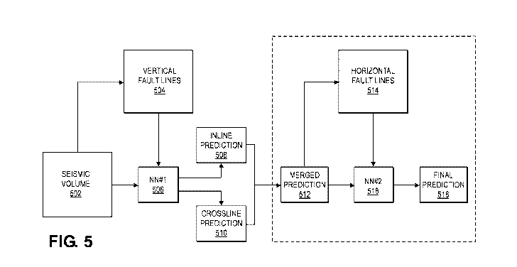
[0071] Figure 5 illustrates a block diagram for interpreting 3D seismic data
with machine
learning techniques, according to embodiments herein. In some examples, a
seismic volume 502
can include any suitable number of three-dimensional seismic data sets. In
some embodiments,
the three-dimensional seismic data sets can include any number of data points
corresponding to
crossline data values and inline data values.
[0072] In some embodiments, vertical fault lines 504 can be labeled within the
seismic volume
502. For example, any suitable subset of vertical planes of data from the
seismic volume 502 can
be labeled for vertical fault lines, false positive values, and the like. In
some embodiments, the
labeled vertical fault lines 504 can be provided to a first neural network
(NN#1) 506. As discussed
above, the first neural network 506 can analyze the remaining vertical planes
of the seismic volume
502 and generate output comprising inline prediction values 508 and crossline
prediction values
510. The inline prediction values 508 can include any suitable representation
of data points
indicating a likelihood or probability of fault lines in the inline vertical
planes of the seismic
volume 502. The inline vertical planes can include a two dimensional vertical
plane of the seismic
volume 502, wherein the inline vertical planes are parallel to the direction
from which the seismic
17
CA 03141760 2021-11-23
WO 2020/243216 PCT/US2020/034779
volume 502 was acquired. The crossline prediction values 510 can include any
suitable
representation of data points indicating a likelihood or probability of fault
lines in the crossline
vertical planes of the seismic volume 502. The crossline vertical planes can
include a two
dimensional vertical plane of the seismic volume 502, wherein the crossline
vertical planes are
perpendicular to the direction from which the seismic volume 502 was acquired.
In some
examples, the inline prediction values 508 and the crossline prediction values
510 can be
represented as three-dimensional probability cubes in which each data point of
the 3D probability
cubes corresponds to a probability of a fault line at that data point.
[0073] In some embodiments, a merged prediction 512 is generated by combining
the inline
prediction values 508 and the crossline prediction values 510. The merged
prediction 512 can be
generated with a maximum function or any other suitable function. For example,
the inline
prediction values 508 and the crossline prediction values 510 can be merged by
creating a merged
three-dimensional probability cube in which each data point is a maximum data
point based on
corresponding data points in the inline prediction 508 and the crossline
prediction 510. In some
examples, the inline prediction values 508 and the crossline prediction values
510 can be merged
with any other suitable function such as a minimum function, an average
function, a mean function,
and the like.
[0074] In some embodiments, a subset of horizontal planes of data 514 from the
merged
prediction 512 can be extracted, labeled, and used to train a second neural
network (NN#2) 516.
In some examples, the number of horizontal planes of labeled data 514 used to
train the second
neural network 516 can be less than the number of vertical planes of labeled
data used to train the
first neural network 506. For example, the second neural network 516 can be
trained with as few
as one or two horizontal planes of labeled data 514 from the merged prediction
512. In some
embodiments, the second neural network 516 can generate output such as the
final prediction 518.
In some embodiments, the final prediction 518 indicates horizontal fault lines
within the merged
prediction 512. In some embodiments, the second neural network 516 can
identify and remove
false positive data values that do not correspond to fault lines. Accordingly,
the final prediction
518 can include fewer false positive data points, which can reduce the noise
of the final prediction
518 to more clearly indicate vertical fault lines and/or horizontal fault
lines.
[0075] In some examples, the final prediction 518 can be any suitable three-
dimensional
representation of data points indicating the probability of horizontal and/or
vertical fault lines. The
18
CA 03141760 2021-11-23
WO 2020/243216 PCT/US2020/034779
final prediction 518 can be displayed within a user interface, transmitted to
an external device,
and/or stored within any suitable computing device. In some embodiments, the
final prediction
518 can be used to modify a drilling plan. The final prediction 518 is
described below in relation
to Fig. 8.
[0076] Figure 6A is an example of a horizontal plane of data from analyzed 3D
seismic data. In
some embodiments, the analyzed 3D seismic data corresponds to a merged
probability cube based
on an inline prediction probability cube and a crossline prediction
probability cube. In some
examples, the first machine learning technique can generate the inline
prediction probability cube
and the crossline prediction probability cube, which can be combined to form
the merged
probability cube based on any suitable function, such as a maximum function,
among others. The
horizontal plane of data 600 of Fig. 6A represents data points along an X axis
and Y axis. The
data points 602 and 604 can represent high probability data values that likely
correspond to
horizontal fault lines. The horizontal fault lines are represented as a
pattern of discontinuity that
can exist in a horizontal direction, a vertical direction, or any combination
thereof In some
examples, the data points 606 and 608 can represent high probability data
values that are likely
false positives for horizontal fault lines because the data points 606 and 608
are isolated.
[0077] Figure 6B is an example of an interpretation of fault lines within a
horizontal plane of
data from analyzed 3D seismic data. In some embodiments, the analyzed 3D
seismic data
corresponds to a merged probability cube based on an inline prediction
probability cube and a
crossline prediction probability cube. In some examples, the first machine
learning technique can
generate the inline prediction probability cube and the crossline prediction
probability cube, which
can be combined to form the merged probability cube based on any suitable
function, such as a
maximum function, among others. In some embodiments, the data points 610 and
612 correspond
to labeled horizontal fault lines. In some examples, the labeled horizontal
fault lines are identified
due to interconnectedness with surrounding high probability data points. For
example, the data
points 610 and 612 belong to a pattern of discontinuity that exists within the
3D seismic data. In
some embodiments, a fault line can be predicted if the pattern of
discontinuity exists within an
area of the 3D seismic data that exceeds a predetermined threshold. In some
embodiments, the
data points 614 and 616 are considered to be false positive values that are
not interconnected with
neighboring high probability data points. Accordingly, in some examples, data
points 614 and 616
are not identified as horizontal fault lines and can be discarded or ignored.
In some embodiments,
19
CA 03141760 2021-11-23
WO 2020/243216 PCT/US2020/034779
the probability values for data points 614 and 616 can be adjusted to a lower
probability value of
neighboring data points.
[0078] Figure 7 is an example diagram depicting output from a first machine
learning technique.
In some embodiments, the output 700 represents a merged representation of a 3D
inline prediction
probability cube and a 3D crossline prediction probability cube. As discussed
above, the output
700 from a first neural network can indicate a probability of vertical fault
lines in a seismic volume.
However, regions 702, 704, and 706, among others, can be noisy and include a
higher percentage
of false positive values. In some examples, regions 702, 704, and 706 can also
lack continuity and
consistency. In some embodiments, the output 700 can be difficult to interpret
due to the
representation of a higher concentration of false positive data values and a
lack of continuity.
[0079] Figure 8 is an example diagram depicting output from a second machine
learning
technique. In some embodiments, the output 800 represents the probability of
vertical fault lines
and horizontal fault lines in a seismic volume. The second neural network can
remove false
positive data points from horizontal planes, which can remove noise from the
output 800. The
second neural network can also improve the continuity and consistency of data
values
corresponding to fault lines. In some embodiments, regions 802, 804, and 806
can include clear
indications of fault structures within a seismic volume. In some embodiments,
the output 800 can
enable the detection of three-dimensional fault structures in a seismic volume
by generating points
within the regions 802, 804, and 806 that indicate a high likelihood of a
horizontal or vertical fault
line at a particular location in a subterranean region.
[0080] In one or more embodiments, the functions described can be implemented
in hardware,
software, firmware, or any combination thereof. For a software implementation,
the techniques
described herein can be implemented with modules (e.g., procedures, functions,
subprograms,
programs, routines, subroutines, modules, software packages, classes, and so
on) that perform the
functions described herein. A module can be coupled to another module or a
hardware circuit by
passing and/or receiving information, data, arguments, parameters, or memory
contents.
Information, arguments, parameters, data, or the like can be passed,
forwarded, or transmitted
using any suitable means including memory sharing, message passing, token
passing, network
transmission, and the like. The software codes can be stored in memory units
and executed by
processors. The memory unit can be implemented within the processor or
external to the processor,
CA 03141760 2021-11-23
WO 2020/243216 PCT/US2020/034779
in which case it can be communicatively coupled to the processor via various
means as is known
in the art.
[0081] In some embodiments, any of the methods of the present disclosure may
be executed by
a computing system. Figure 9 illustrates an example of such a computing system
900, in
accordance with some embodiments. The computing system 900 may include a
computer or
computer system 901A, which may be an individual computer system 901A or an
arrangement of
distributed computer systems. The computer system 901A includes one or more
analysis
module(s) 902 configured to perform various tasks according to some
embodiments, such as one
or more methods disclosed herein. To perform these various tasks, the analysis
module 902
executes independently, or in coordination with, one or more processors 904,
which is (or are)
connected to one or more storage media 906. The processor(s) 904 is (or are)
also connected to a
network interface 907 to allow the computer system 901A to communicate over a
data network
909 with one or more additional computer systems and/or computing systems,
such as 901B, 901C,
and/or 901D (note that computer systems 901B, 901C and/or 901D may or may not
share the same
architecture as computer system 901A, and may be located in different physical
locations, e.g.,
computer systems 901A and 901B may be located in a processing facility, while
in communication
with one or more computer systems such as 901C and/or 901D that are located in
one or more data
centers, and/or located in varying countries on different continents).
[0082] A processor can include a microprocessor, microcontroller, processor
module or
subsystem, programmable integrated circuit, programmable gate array, or
another control or
computing device.
[0083] The storage media 906 can be implemented as one or more non-transitory
computer-
readable or non-transitory machine-readable storage media. Note that while in
the example
embodiment of Figure 9 storage media 906 is depicted as within computer system
901A, in some
embodiments, storage media 906 may be distributed within and/or across
multiple internal and/or
external enclosures of computing system 901A and/or additional computing
systems. Storage
media 906 may include one or more different forms of memory including
semiconductor memory
devices such as dynamic or static random access memories (DRAMs or SRAMs),
erasable and
programmable read-only memories (EPROMs), electrically erasable and
programmable read-only
memories (EEPROMs) and flash memories, magnetic disks such as fixed, floppy
and removable
disks, other magnetic media including tape, optical media such as compact
disks (CDs) or digital
21
CA 03141760 2021-11-23
WO 2020/243216 PCT/US2020/034779
video disks (DVDs), BLURAY disks, or other types of optical storage, or other
types of storage
devices. Note that the instructions discussed above can be provided on one
computer-readable or
machine-readable storage medium, or alternatively, can be provided on multiple
computer-
readable or machine-readable storage media distributed in a large system
having possibly plural
nodes. Such computer-readable or machine-readable storage medium or media is
(are) considered
to be part of an article (or article of manufacture). An article or article of
manufacture can refer to
any manufactured single component or multiple components. The storage medium
or media can
be located either in the machine running the machine-readable instructions, or
located at a remote
site from which machine-readable instructions can be downloaded over a network
for execution.
[0084] In some embodiments, computing system 900 contains one or more
interpretation
module(s) 908. In the example of computing system 900, computer system 901A
includes the
interpretation module 908. In some embodiments, a single interpretation module
908 may be used
to perform some or all aspects of one or more embodiments of the methods. In
alternate
embodiments, a plurality of interpretation modules 908 may be used to perform
some or all aspects
of techniques described herein.
[0085] It should be appreciated that computing system 900 is only one example
of a computing
system, and that computing system 900 may have more or fewer components than
shown, may
combine additional components not depicted in the example embodiment of Figure
9, and/or
computing system 900 may have a different configuration or arrangement of the
components
depicted in Figure 9. The various components shown in Figure 9 may be
implemented in hardware,
software, or a combination of both hardware and software, including one or
more signal processing
and/or application specific integrated circuits.
[0086] Further, the steps in the processing methods described herein may be
implemented by
running one or more functional modules in information processing apparatus
such as general
purpose processors or application specific chips, such as ASICs, FPGAs, PLDs,
or other
appropriate devices. These modules, combinations of these modules, and/or
their combination with
general hardware are all included within the scope of protection of the
invention.
[0087] Geologic interpretations, models and/or other interpretation aids may
be refined in an
iterative fashion; this concept is applicable to embodiments of the present
methods discussed
herein. This can include use of feedback loops executed on an algorithmic
basis, such as at a
computing device (e.g., computing system 900, Figure 9), and/or through manual
control by a user
22
CA 03141760 2021-11-23
WO 2020/243216 PCT/US2020/034779
who may make determinations regarding whether a given step, action, template,
model, or set of
curves has become sufficiently accurate for the evaluation of the subsurface
three-dimensional
geologic formation under consideration.
[0088] The foregoing description, for purpose of explanation, has been
described with reference
to specific embodiments. However, the illustrative discussions above are not
intended to be
exhaustive or to limit the invention to the precise forms disclosed. Many
modifications and
variations are possible in view of the above teachings. Moreover, the order in
which the elements
of the methods are illustrated and described may be re-arranged, and/or two or
more elements may
occur simultaneously. The embodiments were chosen and described in order to
best explain the
principals of the invention and its practical applications, to thereby enable
others skilled in the art
to best utilize the invention and various embodiments with various
modifications as are suited to
the particular use contemplated.
23