Note : Les descriptions sont présentées dans la langue officielle dans laquelle elles ont été soumises.
DEVICE AND METHOD FOR 3D SAMPLING WITH AVIAN RADAR
FIELD OF THE INVENTION
[0001] This invention relates to ground-based radar systems and methods.
The invention
relates more additionally and more specifically to radar target tracking
within a volume and
the derivation of detailed information about the activity at 3D locations
within the volume
over various time scales. The invention is particularly useful in radar
surveillance of birds
and other airborne targets such as general aviation aircraft that fly unknown
patterns.
BACKGROUND OF THE INVENTION
[0002] Avian radars are used to track birds in flight in the vicinity of
airfields, wind
fauns, communications towers, oil and mining operations, and along migration
routes. Birds
are a significant hazard to aviation safety. Applications that require bird
monitoring are the
bird aircraft strike hazard (BASH) management problem and the natural resource
management (NRM) problem. Billions of dollars in damage to aircraft and
significant loss of
life have been recorded due to birds flying into aircraft, particularly during
take-off and
landing in the vicinity of airports.
100031 The danger associated with birds depends on their altitude (among
other factors).
End-users of bird detection and tracking radars need to know the 3D locations
(i.e. latitudes,
longitudes and altitudes) of tracked birds. State-of-the-art avian radars
provide target tracking
only within a slice of the 3D surveillance volume and with high-resolution
localization only
in two dimensions.
[0004] As with any instrumentation that continuously collects data,
digital avian radars
generate large volumes of information. To be beneficial, those data must be
analyzed and
presented in a manner that is relevant to the end-user. The three-dimensional
locations of the
targets are one of the most important pieces of infolination obtained from
avian radar tracks.
The more accurate and precise the data, the more useful they are. Location is
of obvious
importance to accurately track the position of the bird over the terrain.
Altitude is important
for determining whether the bird is at an altitude such that it poses a threat
to aircraft in flight.
Date Recue/Date Received 2022-04-28
[0005] In order to try and assess bird behavior, wildlife managers and
ornithologists
visually monitor birds. They identify and count birds at various locations and
times of day,
and may also note additional information such as the species, flight pattern,
altitude, etc.
Because of limited resources, these counts tend to be sparse in both their
spatial and temporal
aspects. Because of the sparseness, the attempted assessment of general bird
behavior lacks
critical information.
[0006] State-of-the-art avian radars use inexpensive, commercial-off-the-
shelf (COTS)
X-band (or S-band) marine radar transceivers, fitted with slotted-waveguide
array antennas,
as well as parabolic reflector or Cassegrain (dish) antennas. The raw received
baseband
signals are digitized, followed by detection, tracking and display of bird
targets. State-of-the-
art avian radars provide continuous, day or night, all-weather, situational
awareness with
automated detection, localization and warnings of hazards within the small
slice of the 3D
surveillance volume they monitor. They provide high-quality, real-time target
track data with
.. sophisticated criteria to determine potentially dangerous target behavior,
as well as
communication of real-time alerts to end-users who require that information.
They also
minimize operator interaction and in-the-loop requirements.
[0007] State-of-the-art avian radars features include:
= Low-cost, high-performance radar antennas and transceivers mounted on ground-
based
pedestals
= Radar processing that can reliably detect and track small maneuvering
targets in dense
target and clutter environments
= Real-time display of target tracks in a geographic framework
= Automatic hazard detection and alert capability to remote end-users
= The formation of radar networks to provide wide-area coverage
= Low cost of operation
= Low life cycle costs
= Data and analysis support for research and development
[0008] COTS marine radars are very inexpensive. These marine radars
exhibit
surprisingly good hardware specifications. However, as-is, these radars
deliver mediocre
performance for bird targets because of their primitive signal processing,
which is only
required to detect marine vessels and land-masses. Combining a COTS marine
radar with a
- 2 -
Date Recue/Date Received 2022-04-28
digitizer board and a software radar processor that runs on a COTS personal
computer (PC)
and a parabolic dish antenna forms a state-of-the-art avian radar, but one
with a very limited
three-dimensional (3D) localization capability.
[0009] Slotted-waveguide array antennas are used to provide two-dimensional
(2D)
localization (i.e. range and azimuth, which can be translated to latitude and
longitude). These
systems provide good volume coverage due to the typically larger vertical
(elevation)
beamwidth, which is on the order of 20 degrees. Such systems, however, cannot
provide
useful altitude estimates of tracked targets when the radar is spinning
horizontally in its usual
orientation. This is because the beam uncertainty in the 3rd dimension
(elevation), which is on
the order of the beam extent (up to 20 degrees), is too large. For example,
the elevation beam
extent or altitude uncertainty for a target at a distance of just 1 km from
the radar is about
1,000 feet. This means that if both a plane and a bird are being tracked by
the radar at a
distance of 1 km away, the radar cannot tell whether the two targets are 1,000
feet apart (i.e.
one is near the ground and the other is at the upper edge of the vertical
beam, 1,000 feet off
the ground) or whether they are at the same altitude where a collision could
occur. While
some radar configurations orient the slotted-array antenna so that it spins
vertically (rather
than horizontally) to get a measure of altitude, see Nocturnal Bird Migration
over an
Appalachian Ridge at a Proposed Wind Power Project, Mabee et al, Wildlife
Society
Bulletin 34(3), 2006, page 683, they still can only operate as 2D radars. In
order to measure
altitude, radars in this configuration can no longer provide 360-degree
azimuthal coverage
(which a conventional azimuth-rotating radar provides).
[0010] Parabolic reflector or Cassegrain (dish) antennas are used today
to provide a very
limited 3D localization capability. These antennas employ a single beam
(pencil shaped),
fixed in elevation, but rotating in azimuth. The azimuth rotation results in
the usual 2D, 360-
degree coverage with localization in range-azimuth or latitude-longitude.
However, by using
a narrow pencil beam (say between 2 and 4 degrees wide), the altitude
uncertainty reduces
significantly as compared to the 20 deg slotted-array antenna. Using the
previous example,
with targets at a distance of 1 km from the radar and a 4-degree dish antenna,
altitude
estimates with uncertainties on the order of 200 feet are now possible. While
providing useful
altitude information at very short ranges, the altitude estimates are still of
limited use at
further ranges. Also, volume coverage is restricted accordingly with the
narrower pencil
beam.
- 3 -
Date Recue/Date Received 2022-04-28
[0011] Merrill I. Skolnik in his Introduction to Radar Systems, 2nd
Edition, McGraw-Hill
Book Company 1980 and his Radar Handbook, 2" Edition, McGraw-Hill, Inc., 1990,
describes altitude-finding radars that use nodding horizontal fan beams. These
radars are
steered to the bearing where targets have been detected by an independent 2D
air-surveillance
radar. These altitude-finding radars cannot get altitude estimates for more
than 20 or so
targets per minute, and have problems with azimuth-elevation (Az-E1)
ambiguities in dense
target environments. Military airborne and land-based tracking radars provide
altitude
information for a single target only (via closed-loop steering in both
dimensions). They use
monopulse or sequential lobing techniques to obtain the off-boresight error
signals, but like
the altitude-finding radars, are unable to perfoim 3D surveillance. Military
3D surveillance
radars, on the other hand, employ rotating phased array antennas that form
either multiple
receive beams or rapidly electronic-scanning pencil beams. See Radar
Applications, Merrill I.
Skolnik, IEEE Press New York, 1987.
[0012] State-of-the-art weather radars use a helical scanning strategy.
These radars foiin a
3D "image" of the rain intensity in each volume element. Weather radar
resolution
capabilities (in both time and space) are not suitable for tracking birds.
[0013] Weather radar presents density of water in the birds as measured by
reflectivity.
This reflectivity can be quantified into migration traffic rates (see S.A.
Gauthreaux and C. G.
Belser, 1998. "Displays of Bird Movements on the WSR-88D: Patterns and
Quantification",
Weather and Forecasting 13: 453-464). With its most detailed data, weather
radar can give an
overview of the density of migrants taking off on migration from localized
areas which can
be correlated with habitat as described by S. A. Gauthreaux and C. G. Belser,
2005, "Radar
Ornithology and the Conservation of Migratory Birds" USDA Forest Service Gen.
Tech.
Rep. PSW-GTR-191. However, even at its best resolution, it cannot track
individual
migrants.
[0014] Avian radars detect and track individual avian targets. In state-of-
the-art avian
radars, the numbers of targets are estimated based on reflectivity. The
altitudinal distribution
of birds is not achievable with the WSR-88D data without access to the data
from individual
scans. Even with data from individual scans the number of birds is inferred
based on
- 4 -
Date Recue/Date Received 2022-04-28
reflectivity. The avian targets tracked by current avian radars can be
resolved into single birds
or groups based on radar cross-section.
[0015] US Patent No. 7,864,103 entitled "Device and Method for 3D Avian
Height-
Finding Radar" describes azimuth scanning systems with means of varying an
elevation
pointing angle. Those radar systems and methods are 3D surveillance volume
scanning
radars. The systems described in U.S. Patent No. 7,864,103 include radars with
multiple
beams, slow elevation scanners, and multiple radars, and cover a 3D
surveillance volume.
100161 US Patent No. 7,940,206 entitled "Low-Cost, High-Perfounance Radar
Networks"
describes at least one radar with a computer on a network that tracks targets
and sends target
data to a radar data server with a database to store and provide data for real-
time and
historical access and connected to users via an interface. The systems can
include detection,
clutter suppression, MHT/IMM (multiple hypothesis tracking / interacting
multiple models),
PPI (plan position indicator) displays, real-time target displays on
background map, multiple
radars, remote control and operation, unattended monitoring with alerts, user-
applications
that integrate data from the database (e.g. real-time data into a common
operating picture
(COP) tactical display), multi-sensor fusion, low RCS targets including birds
and aircraft,
COTS marine radars, COTS computers, SQL databases, SIMD (serial instruction
multiple
data) programming, software-configurable processors, web servers providing
data to user
client applications for accessing past and live data, and track data including
range, azimuth,
lat, long, altitude, intensity, heading, speed, echo size, date/time.
SUMMARY OF THE INVENTION
100171 The present invention aims to provide effective, affordable, and
continuous 3D
target sampling of airspaces in the vicinity of aerodromes that complement and
fill in the
spatial and temporal gaps in situational awareness associated with visual
observation
methods. More generally, the present invention is directed to improved state-
of-the-art avian
radar systems that extend current 2D target localization capabilities to 3D
ones.
Concomitantly, the present invention aims also to provide means to affordably
upgrade
existing 2D avian radar systems so that they can localize bird targets in 3D.
- 5 -
Date Recue/Date Received 2022-04-28
[0018] The present invention seeks to provide an affordable volume-
scanning avian radar
system capable of localizing bird targets and other targets in three
dimensions (latitude,
longitude, and altitude). More particularly, the present invention
contemplates affordable
cylindrical volume radar coverage and situational awareness of birds in an
airspace of interest
that extends to 10,000' or more above ground level and to 6 nautical miles or
further in range,
360 degrees in all directions.
[0019] The present invention aims in part to maintain or extend all of
the user-friendly
features of 2D avian radars (e.g. real time display, networking and alerting)
to 3D.
Furthermore, the present invention seeks to provide the means of producing
significantly
more accurate target altitude estimates, as compared to conventional 2D avian
radars with
array antennas, while also increasing overall volume coverage.
[0020] The present invention contemplates providing means of producing
significantly
greater volume coverage, as compared to conventional avian radars employing
dish antennas,
while not reducing the accuracy of target altitude estimates.
[0021] The present invention also contemplates providing means for
generating images,
graphs and tables (avian activity reports) of bird abundance and behavior at
various locations
within the surveillance volume. More specifically, the present invention
contemplates
depiction of bird altitudes, sizes, concentrations, speeds and heading
directions.
[0022] The present invention aims to provide means for filtering the data
in order to
produce avian activity reports based on both characteristics of bird behavior
and on time and
place.
[0023] The present invention has the additional aim of depicting bird
abundance and
behavior in a geographic framework.
[0024] In a related matter, the present invention contemplates the
provision of avian
activity reports that clearly and simply present the information needed to
support BASH,
NRM and UAS sense and avoid requirements. The avian activity reports are
preferably
provided in a timely fashion to support BASH, NRM and UAS sense and avoid
requirements.
- 6 -
Date Recue/Date Received 2022-04-28
[0025] The present invention aims in important part to integrate the use
of real-time track
displays and near-term target activity reports to increase situational
awareness of hazardous
activity in the airspace, support a directed response, and serve as a force
multiplier.
[0026] The present invention also aims to provide avian activity reports
for arbitrary user-
specified time intervals in the past, to provide the avian activity reports to
remote network-
accessible end-users, and to provide the avian activity reports as Web pages.
[0027] The present invention contemplates enablement of 3D avian radars
to distribute
their information seamlessly onto radar networks and to remote end-users and
to remote
integrated tactical (COP) displays.
[0028] The present invention aims further to provide information (and
avian activity
reports) suitable for regional, national and continental bird advisory
systems.
[0029] The present invention recognizes the need for avian radars to scan
a 3D
surveillance volume for bird (or other airborne) targets. Avian radars need to
gather the
information from the volume scanning process and present it to avian radar end-
users in
formats that suit their needs. The aim of the current invention is to provide
next-generation
.. avian radars with avian information in a number of useful formats, thereby
overcoming
limitations in the current state of the art. In so doing, the present
invention bridges some of
the information gaps (both spatial and temporal) in existing systems so as to
improve wildlife
managers' ability to evaluate avian activity.
[0030] The end-users of avian radars need the information gathered from
them organized
into formats that they can interpret and act upon. These formats include
descriptions of bird
activity in various subsets of the volume at different times and time-scales.
The present
invention incorporates mechanisms that facilitate the conversion of the
"conventional" radar
data (i.e. the time-evolving target tracks) into more integrated avian
activity reports suitable
.. for wildlife managers.
[0031] For example, visual point counts taken at one end of a runway may
note certain
bird species present over at particular times. Visual point counts at another
location on the
airfield some distance away and at different times may also note birds of the
same species.
- 7 -
Date Recue/Date Received 2022-04-28
However, it is impossible to confirm that these are the same birds without
tagging them.
Avian radar, on the other hand, in accordance with the present invention, can
continuously
monitor the large 3D surveillance volume, track all birds therein, provide 3D
localization for
them, and generate bird activity reports showing their movement patterns and
confirming that
these same birds are moving from one location to the other.
[0032] Wildlife managers need presentation products that depict the avian
activity in a
highly intuitive manner. The simplest forms of graphical presentation are
abundance charts.
Although these can summarize very useful data, they lack the ability to
project the behavior
of the birds onto a geographic framework. The present invention portrays the
information
about bird behavior and abundance as color-coded grids or grids of arrows or
symbols
overlaid onto background maps. Colors and shades best depict scalar quantities
like bird
density, while arrows are used to depict flowing directional quantities like
velocity. With
reports in these formats, end-users can interpret avian activity much more
effectively.
[0033] The end-users of avian radar information are typically not located
near the radar
sensor nor near the computers that process the sensor data. Distribution of
the information
over networks (including the World-Wide Web) is of obvious benefit to remote
end-users.
The present invention is designed to deliver the avian activity reports to
many end-users,
typically via Web pages, in a timely and convenient manner.
[0034] Avian activity reports in accordance with the present invention
exploit high-
resolution bird-track data recorded over a few minutes to several years worth
of data. These
reports allow biologists to investigate the spatial and temporal patterns of
bird abundance,
movements, and deviations from long-term baselines of resident populations,
commuting
birds, and migrants. With these detailed movements referenced to geographical
information
systems (GIS), the data can be imported into tools that are familiar to end-
users (e.g.,
ArcGIS) to further investigate abundance and movement patterns. Altitudinal
distributions
throughout the 3D surveillance volume provide additional information on
hazardous bird
movements around an airfield.
[0035] As will be apparent from the drawings and descriptions herein, the
present
invention, unlike conventional state-of-the-art avian radars, an avian radar
that captures
- 8 -
Date Recue/Date Received 2022-04-28
information on bird activity in the majority of a 3D surveillance volume and
does not leave
significant gaps of situational awareness for wildlife managers.
[0036] Conventional avian radars have a very limited three-dimensional
(3D) localization
capability. The present invention modifies conventional avian radars via
custom antenna
volume scanning and processing, thereby providing for effective 3D scanning
and coverage
of a very large surveillance volume and enabling the production of bird
activity information
about the entire airspace in the vicinity of an aerodrome of interest.
[0037] The present invention seeks to overcome the limitations of fixed-
elevation
azimuth-rotating pencil-beam radars using parabolic or Cassegrain (dish)
antennas by
providing scanning in the third (elevation) dimension. In particular, means
are disclosed
herein to provide both greater volume coverage and estimates of altitude
within the volume,
both of which serve to provide excellent, detailed, bird activity information
never before
available.
[0038] Like certain state-of-the-art radar systems, the present invention
is directed to true
3D surveillance. An antenna in one system in accordance with the present
invention rotates
in azimuth while changing its elevation tilt angle. However, the present
invention is low-cost,
while military 3D radar systems are orders of magnitude more expensive,
because of their
phased array antennas. The present invention does not use expensive phased
arrays but uses
marine radars and PC-based processing to achieve considerable cost reduction,
especially as
compared to military systems.
[0039] The preferred embodiments of present invention do not provide
instantaneous
coverage of the whole 3D surveillance volume. The radar sensor must spend some
time
surveying each different sub-volume, and coverage of the entire volume takes a
few minutes.
In this respect, the present invention is similar to a weather radar. Either a
multitude of
single-beam radar systems or one with a multiple-beam phased array (or the
like) is needed if
one desires to get full volume coverage in seconds. In applications of the
present invention,
full volume coverage in minutes is all that is required to generate hourly
activity reports.
These are frequent enough to provide situational awareness throughout the
airspace in the
vicinity of an aerodrome of interest where managers can understand developing
hazards and
act upon them to improve safety.
- 9 -
Date Recue/Date Received 2022-04-28
[0040] Weather radar resolution capabilities (in both time and space) are
not suitable for
tracking birds. Avian radar applications require a greater resolution and
detail than weather
radars could provide, to discover behavior of individual birds or flocks, for
example,
commuting each morning across an active runway to feed and returning at night,
so that the
resulting hazards can be mitigated. Wildlife managers need to follow tracks
converging to
roosting sites, for example, so that they can remove hazardous birds. The
track interpretation
engine of the present invention allows such spatial/temporal behavior patterns
to be
discovered.
[0041] The preferred systems perform detection and tracking, distribute
tracks to
network, provide real-time displays, and refine target data to user-specific
products such as
statistical summaries and alerts. They store track data to a database. The
differentiators of the
present invention are:
= 3D volume scanning systems and methods are disclosed for 3D data sampling of
a large
3D surveillance volume and include novel scan patterns that support bird
activity
situational awareness
= Effective means for providing coverage of cylindrical surveillance volume
with a
plurality of elevation steps is disclosed
= Novel multi-sensor combinations (e.g. fixed plus agile) are disclosed for
effectively and
affordably providing coverage and awareness throughout a large 3D surveillance
volume
= Avian (or other airborne target) track interpreter is novel and optimally
assesses and
depicts avian activity in 3D
= Preferred database and optimized processor designs are disclosed for
efficiently and
cost-effectively organizing detailed track data for 3D sampling and activity
report
generation
= Novel data products are introduced that derive from the high-resolution,
3D track
information
= Present invention is directed towards providing 3D sampling of a large 3D
surveillance
volume which is complimentary to the real-time monitoring taught in U.S.
Patent No.
7,864,103
- 10 -
Date Recue/Date Received 2022-04-28
= Primary object of U.S. Patent No. 7,864,103 is to provide altitude
information for state-
of-art-avian radars; the primary object of the present invention is 3D
sampling
[0042] As used above, "3D sampling" in accordance with the present
invention means: i.
tracking birds within 3D volumes; ii. assessment of avian activity within 3D
volumes; and Hi.
creation of user-reports that intuitively depict avian activity and behavior
within 3D volumes.
[0043] The present invention may include many features disclosed in
US
Patent No. 7,940,206. The present invention distinguishes over US Patent No.
7,940,206 as
follows:
= 3D volume scanning systems and methods ¨ U.S. Patent 7,940,206 only
considers 2D
surveillance radars including dishes pointed to a fixed elevation angle to
compute
altitude as target_altitude = target range * sin(beam elevation)
= Novel multi-sensor combinations (e.g. fixed plus agile) are disclosed for
effectively and
affordably providing coverage and awareness throughout a large 3D surveillance
volume
= Avian (or other airborne target) track interpreter is novel and optimally
assesses and
depicts avian activity in 3D
= Special-purpose database(s) organized for 3D sampling
= Novel RDS ¨ GDS (Radar Data Server - Geographic Data Server) design
= Novel data products are introduced that derive from the high-resolution,
3D track
information
= Method/System designed to provide 3D sampling as opposed to real-time
monitoring
= Primary objects of U.S. Patent No. 7,940,206 are directed to state-of-the-
art avian radar
networks, organizing radar target information in an RDS to give users network
access
to radar data; the primary object of the present invention is 3D sampling
[0044] It will be obvious to those skilled in the art that the same
improvements described
herein are applicable to low-cost radars used in other applications such as
homeland security.
The focus on 3D sampling of birds in this disclosure is in no way intended to
limit the scope
and application for the invention disclosed herein to birds. Reports on
aircraft (including
general aviation aircraft and ultralights) activity at various times and time-
scales within a
surveillance volume will be of great use to intelligence-driven security
operations. 3D
- 11 -
Date Recue/Date Received 2022-08-22
sampling in accordance with the present invention is also very useful for
ground-based sense
and avoid (GBSAA) systems that would support unmanned aerial system (UAS)
applications.
The UAS operator is interested in situational awareness of both birds and GA
aircraft in the
vicinity of the UAS and the present invention is very well suited to providing
such awareness
throughout the 3D surveillance volume containing the UAS. Any radar with
multiple-target
tracking capability could also use the apparatus and methods described herein
to provide
activity reports in accordance with the present invention. Examples of such
radars are
described in US Patent No. 7,940,206.
100451 With the present invention, volume-scanning techniques are applied
to avian radar
systems in order to provide a means for providing 3D information about
detected bird targets
throughout a surveillance volume. The present invention provides continuous
avian sampling
within an upright cylindrical coverage region with the radar at the bottom
centre. The present
invention not only scans the volume and tracks bird targets within it, but
also provides
detailed summary reports to end-users about the avian activity within the
volume. The
invention uses novel scanning methods and data integration methods to produce
succinct
summaries on the levels of activity of birds within the surveillance volume.
The invention
operates on the following sequence:
1) Repeatedly scan the volume with radar to obtain 3D tracks of bird targets;
2) Store and organize the information contained in these tacks in a relational
database
specially-designed for efficient spatial-temporal activity report queries;
3) Periodically and by request query the track database to obtain filtered
subsets of the
track data; and
4) Process the received data to generate reports that summarize avian activity
100461 In accordance with the present invention, a 3D avian radar
sampling system has
two basic components: a volume scanning radar and an avian track
interpretation engine (or
avian track interpreter). The volume scanning radar preferably rotates its
antenna (via a
scanner) about two axes; this allows the antenna pointing direction to vary in
both azimuth
and elevation. The volume scanning radar preferably includes a state-of-the-
art radar
transmitter and receiver, and a custom digital processor configured for
detecting and
localizing airborne targets in azimuth, elevation and range and preferably
transforming those
to earth coordinates, namely, latitude, longitude and altitude or other earth
coordinates known
to those skilled in the art. The avian track interpretation engine receives
the tracks from the
- 12 -
Date Recue/Date Received 2022-04-28
volume scanning radar, and reorganizes the information contained within them
into avian
activity reports suitable for visualization and interpretation by end-users.
The engine
preferably includes a track database that stores the tracks for subsequent
querying by an
illustrator application or processor, which creates the reports.
[0047] A related method of sampling the abundance and behavior of birds
within a 3D
surveillance volume is to operate a radar system to successively illuminate,
detect and track
the targets within sub-volumes of the complete volume. These sub-volumes are
preferably
slices that can be illuminated by varying a pointing angle of the radar
antenna. While the
volume is being interrogated, the information about the bird targets tracked
within each sub-
volume is collected and organized. At some later time, using this infoimation,
reports are
created that convey the bird abundance and behavior within the 3D volume.
[0048] The first part of the present invention concerns practical
improvements over state-
of-the-art 2D avian radar systems, including improvements in antenna designs
and related
and necessary radar transceiver modifications. The improvements include the
following
features:
= 3D cylindrical volume coverage
= Improved altitude estimation within the covered volume
= Inexpensive and incremental augmentation of current systems
= Low sidelobe response at ground level (zero elevation)
= Narrow-beam azimuth and elevation response
[0049] In accordance with the first part of the present invention, the
following general
radar system designs provide (to varying degrees) the desired features listed
above:
1. A radar system with a pencil beam that slowly scans up and down in
elevation, while
rotating rapidly in azimuth.
2. A radar system with a pencil beam that slowly rotates in azimuth, while
rotating rapidly
in elevation.
3. Two or more 2D azimuth-rotating pencil-beam radar systems operating side-by-
side at
different fixed elevation angles.
4. Two or more 2D elevation-rotating pencil-beam radar systems operating side-
by-side
at different fixed azimuth angles.
- 13 -
Date Recue/Date Received 2022-04-28
5. A radar system with one or more 2D azimuth-rotating pencil-beam radar
systems
operating side-by-side with one or more 2D elevation-rotating pencil-beam
radar
systems.
6. A radar system with two or more vertically-stacked pencil beams that
rotates in
azimuth.
7. A radar system with two or more horizontally-displaced pencil beams that
rotates in
elevation.
8. Any of the above systems with fan beams instead of pencil beams.
[0050] Systems 1 and 2 above (referred to herein as dual-axis scanning
radars) will not
get instantaneous volume coverage, but will get full volume coverage over
time. Systems 3, 4
and 5 above are costlier in terms of hardware and real estate, more difficult
to integrate, and
require more than 2 radars to cover the full cylindrical volume. Systems 6 and
7 are costlier
still, and also need more than 2 beams for full coverage. Systems with fan
beams (8) suffer
from poor spatial resolution in the dimension of their fan extent. System 1 is
preferred
because it matches the coverage volume better than 2, and allows the tracking
of level-flying
birds (and aircraft) with all possible headings.
[0051] A preferred form of the first part of the present invention is
the slow-elevation-
scanning system (1 above). The radar typically samples the volume using a
(quasi) helical
scan, where the antenna rotates rapidly in azimuth while slowly nodding (or
stepping) in
elevation. Nodding is preferably by mechanical means because of lower cost,
but electronic
means (including frequency-scanning and phased-array implementations) are
within the
scope of the present invention. Nodding is slow enough that targets remain
within the beam
for several consecutive scans, long enough to form tracks. The apparatus must
be able to
control nodding while rotating in azimuth. It utilizes a scanning mechanism
that provides the
antenna with two axes of rotation. Elevation coverage is not obtained
instantaneously (i.e.
within the few seconds it takes for one azimuth rotation), but over periods of
a few minutes.
[0052] The slow-elevation-scanning system cannot detect every bird in the
surveillance
volume. Rather, it samples the hourly, daily, or seasonal activity (in this
respect, it is like a
weather radar). This system has some key advantages over other solutions:
- 14 -
Date Recue/Date Received 2022-04-28
= It is more flexible in the choice of coverage region (e.g. could look
between 50 and 100
elevations during day, between 100 and 200 at night).
= It is typically a much simpler increment to currently existing solutions:
= The antenna is a conventional dish, no modifications to the receiver and
A/D system
are required, and
= the changes to the processing are confined to the interpretation of the
track data.
[0053] In order to accurately locate the tracked targets, the processor
needs to be kept
informed of the antenna azimuth (Az) and elevation (El) positions (via signals
from the
scanner). The processor preferably controls elevation according to operator-
set parameters.
[0054] The antenna beam response is preferably that of a pencil beam.
However, the
azimuth beamwidth need not equal the elevation beamwidth, and elliptical beams
or fan
beams may be favored in certain applications. The beam preferably has
reasonably low
largest sidelobes (preferably below ¨20 dB). A preferred embodiment of a
pencil-beam
antenna in accordance with the present invention is a dish reflector antenna
with a central
feed. Either reflectors with offset feed designs or flat-plate antennas may be
preferred for
achieving lower sidelobes (by eliminating feed blockage).
[0055] The antenna preferably rotates continuously 3600 in azimuth at
preferably at-least
24 revolutions per minute (RPM) while transmitting and receiving. It may be
desirable to
have a selectable rotation rate. The rotating antenna is typically mounted
near ground level; it
could be on the roof of a trailer or a small building, or it could have its
own dedicated
structure. Some sites may require the antenna to be raised to 10 feet or so
above ground in
order to clear nearby obstructions. The rotating antenna is usually protected
from (or immune
to) the environment (wind, rain, dirt, etc.); any protective measures (such as
radomes) should
not significantly distort beam patterns nor raise sidelobes above tolerable
levels. The rotating
antenna boresight must be (mostly) unobstructed from mechanical apparatus;
some
applications may tolerate an obstructed azimuth sector.
[0056] The antenna preferably rotates more slowly in elevation so that
different conical
slices (sub-volumes) are illuminated by the radar continuously for many
azimuth rotations.
This allows targets within a given slice to be tracked long enough to achieve
reliable position
- 15 -
Date Recue/Date Received 2022-04-28
and velocity estimates. After one slice has its turn, the antenna moves to
another elevation,
and another slice is illuminated. The whole cylindrical volume (possibly minus
a small cone
directly overhead of the radar) is sampled in the time it takes the antenna to
move in elevation
from its lowest to its highest settings (or vice-versa). Of course a hemi-
spherical volume
.. could be used in place of a cylindrical one.
[0057] The present invention preferably uses a custom-designed elevation
scanning
apparatus preferably fitted to a COTS radar transceiver and (azimuth) scanner
and antenna
(although using a custom-built radar transceiver to facilitate integration
still falls in the spirit
.. of this invention). The elevation scanning apparatus consists of a servo-
controlled motor that
can tilt the antenna to a specified angle and a waveguide joint that peunits
RF energy to
propagate to and from the antenna at different elevation angles. The waveguide
joint can
employ a flexible waveguide. An azimuth rotary joint with a slip ring
connection provides a
path for RF, power for the motor (preferably a high-quality stepper motor),
and elevation
.. control signals while the motor, elevation waveguide joint and antenna
rotate in azimuth. An
elevation feedback signal may also be provided back down to the processor. A
wireless
connection, a battery, and/or some other state-of-the-art schemes, could
alternatively provide
RF, power and/or control to the motor, thereby obviating the need for a
specialized rotary
joint. The antenna is preferably a dish antenna in accordance with the
invention.
[0058] An alternate scanning apparatus could use a COTS radar transceiver
and
(azimuth) scanner operating on its side so its beam scans the vertical plane.
Rather than
adding a second dimension of rotation to the scanner, the entirety can be
placed on a turntable
that rotates in the horizontal plane slowly to provide 360o coverage. The
antennas that could
.. be used include a dish or an array.
[0059] A preferred embodiment is to have the scanning pattern
programmable in software
and changeable by the user according to sampling requirements. Some
applications would
prefer to have the entire volume scanned at a rapid rate (e.g. 15 min or less)
with only short-
.. duration tracks formed at each elevation step. Others would prefer longer-
duration tracks, and
thus tolerate slower volume scanning rates (e.g. up to 2 hours). Non-linear
and non-
monotonic scan patterns are also possible.
- 16 -
Date Recue/Date Received 2022-04-28
[0060] A second form of the first part of the present invention, which is
an alternative to
the dual-axis scanning system described above, involves using two (or more)
independent
avian radar systems operating side-by-side with their respective antennas set
at different fixed
elevation angles. Each avian radar tracks targets within its respective
coverage volume slice,
using its own receiver and processor. Track data from each radar are combined
in the avian
track interpretation engine. The engine may use fusion processing methods know
to those
skilled in the art.
[0061] In accordance with the present invention, the volume-scanning
radars are
preferably customized avian radars and the 3D avian radar sampling systems
preferably
exploit components and architectures associated with avian radar networks.
Avian radars and
networks are known to those skilled in the art, and are described in the
following: Could
Avian Radar have Prevented US Airways Flight 1549's Bird Strike?, Nohara, T J,
2009 Bird
Strike North American Conference, September 14-17, 2009, Victoria, B.C.,
Reducing Bird
Strikes ¨ New Radar Networks can help make Skies Safer, Nohara, T J, Journal
of Air Traffic
Control, Vol 51, No. 3, Summer 2009, pages 25 to 32, Affordable Avian Radar
Surveillance
Systems for Natural Resource Management and BASH Applications, Nohara, T J et
al, 2005
IEEE International Radar Conference, May 9-12, 2005, Arlington, VA, and US,
U.S. Patent
No. 7,940,206 entitled "Low-cost, high-perfoimance radar networks", and U.S.
Patent No.
7,864,103 entitled "Device and method for 3D height finding radar".
[0062] Regardless of the folin of the first part of the present
invention, the radar
processor detects and tracks bird targets. Target tracking preferably uses
state-of-the-art
multi-target tracking algorithms known to those skilled in the art such as
those detection and
tracking algorithms described in US Patent No. 7,940,206 Low-cost, High-
performance
Radar Networks. A multi-target tracker facilitates target track association
and allows for
smoothing and improved estimation of the target position and dynamics.
100631 The second part of the present invention is the avian track
interpretation engine
which concerns the organization and presentation of track data so as to
provide summary
reports of bird activity over various time scales, including hourly, daily,
weekly, monthly and
yearly. Avian activity reports take the form of tables, graphs and images or
any collection of
these that illustrate the bird abundance and behavior during certain time
intervals at certain
locations. In particular, the activity reports summarize statistics about
those birds with user-
- 17 -
Date Recue/Date Received 2022-04-28
specified attributes at these intervals and locations. Both the statistics and
the specified
attributes can include any information that can be derived from the track
data, such as speed,
heading, radar cross-section (RCS), track duration, track density, altitude,
as well as
abundance. An example avian activity report could be an hourly plot of the
number of birds
with cross sections greater than -15 dBm2 within the departure corridor of a
given runway, or
the distribution of such birds across an entire airfield, on a spatial grid of
say 200m by 200m
cells.
[0064] To begin the organization process, the tracks from the avian
radars are preferably
written to a track database as soon as they are created. This database is
queried by an activity
illustrator application or processing engine for specified records whenever an
activity report
is to be generated. Activity reports are generated on regular time intervals,
or upon request
from an operator. The track database is preferably a state-of-the-art
relational, SQL database
which specially designed schemas that organizes the data so that it can be
efficiently queried
at the same time as the new track data are (continually) being stored. The
track database is
preferably a component of a Radar Data Server (RDS), which performs the
functions of
receiving target target data (including track data, detection data, alerts and
meta data) from
various radars, storing the data in the track database, and serving the target
data to various
users and applications.
[0065] The RDS records all processed target track data on a scan-by-scan
basis, that is, it
is organized based on a timestamp that increments on every scan by the radar
antenna's
azimuth rotational period. This creates an organization that is time-based,
which is well
suited for recording, live network distribution of data, and simulated real-
time playback of
target tracks. However, a time-based organization is not well suited to
geographical and
geometric analysis of target tracks. A target track will typically exist for
many scan intervals,
representing a single object in space and time with a number of measureable
attributes (e.g.
velocity, radar cross section, heading, altitude etc.). A geographic
information system (GIS)
database-friendly organization of the data is required in order to be able to
be able to make
efficient queries on a track, rather than purely a time, basis. One example of
a track-object
oriented GIS query is: "How many individual track objects (i.e. birds or
flocks) were present
in a polygonal coverage area over the last 24 hours that had an average
velocity less than 10
m/s and an altitude less than 500 feet AGL?"
- 18 -
Date Recue/Date Received 2022-04-28
[0066] The geographic or geographical data server (GDS), which is also
preferably a
state-of-the-art relational database with GIS extensions/plugins known to
those skilled in the
art) in accordance with the current invention performs a real-time, on-the-
fly, re-organization
of the scan-by-scan track data into GIS-friendly track-oriented entries. Each
track entry that is
created preferably contains a globally unique track ID that identifies the
track over all time
and all radars, a LINESTRING-type GIS object that contains the target's
location in 3D space
and time over the life of the track (i.e. its trajectory), and summary
statistics of the track
attributes computed over the life of the track that give average, median,
minimum, maximum,
and other statistics that in turn make it possible to perform coarse filtering
of tracks
efficiently and rapidly. This organization allows a user to display filtered
track histories or
perform further computations on a track-by-track basis. This also allows users
to combine
GIS track information from multiple radars into a single database for further
analysis.
[0067] Other GIS-enabled tables within the GDS contain information about
the
deployment area coverage, the radar site locations within the deployment area,
and the DRPs
deployed at each site.
[0068] The avian track interpretation engine preferably processes both
regular standard
and occasional user-specific requests for activity reports. Based on the
specifics of a given
request, the interpreter first queries the track database for the appropriate
records. It then
processes the obtained data and creates the graphs, images, tables and text
that constitute the
avian activity report. The activity reports are distributed to end-users via
state-of-the-art
methods, with near-term activity reports preferably generated at least a few
times per hour to
provide increased and on-going situational awareness of the current situation.
One of these
methods is to provide flexible access via Web pages over the Internet,
accessible in the Cloud
by remote computers and mobile devices. The combination of using near-term
activity
reports to highlight developing hazardous situations coupled with real-time
track displays to
locate and direct responses to particular hazardous birds is a novel, tactical
feature of the
present invention. More distant (older) activity reports are used to
investigate whether a
developing hazardous situation is a repeating occurrence or pattern allowing
more strategic
actions to be taken.
[0069] The present invention employs state-of-the-art techniques for
poittaying multi-
dimensional information that are used in other fields. For example, weather
radar services
- 19 -
Date Recue/Date Received 2022-04-28
provide diagrams where color-coded grids are overlaid onto background maps,
the colors
depicting the intensity of precipitation at the overlaid location. For avian
applications, this
form of presentation is useful for depicting scalar quantities like bird
density, as well as
statistics of other quantities such as mean bird altitude, median bird speed,
etc. Contours are
also useful for depicting these same quantities, but are not as intuitive to
many end-users.
Another form of presentation overlays a grid of arrows onto a background map.
This foim is
better for depicting flowing directional quantities like velocity and heading.
The lengths,
thicknesses and colors of the individual arrows encode location-dependent
information such
as mean speed, number of birds, etc. These diagrams depict the moving aspects
of the bird
behavior, e.g. the birds are travelling from this location to that, as opposed
to the more static
aspects, e.g. how many birds of a certain size were at this location.
[0070] 3D sampling and the generation of timely avian activity reports in
accordance
with the present invention compliment real-time track displays to dramatically
increase
situational awareness, giving early warning to operators of developing hazards
that become
persistent for a period of time. Such activity reports can be simply glanced
at to understand
and appreciate that a new hazardous situation has started to develop and is
increasing risk at a
particular location in the surveillance volume. If a bird strike is reported,
for example, a
quick glance at the activity report can indicate whether this was an isolated
incident, or
whether a persistent situation is underway, such as a significant movement of
migrants that is
occurring in the same air space used by active runways. As operators are busy
with many
functions, not having to stare at avian radar displays is a significant force
multiplier. With a
glance, operators can issue warnings to pilots, as well as notify air
operations personnel to
help mitigate the risk, for example by driving out to the location in question
and harassing the
birds to alter their flight path and leave the airspace. Conventional real-
time track displays
can be used by response personnel to locate the birds in need of harassing. A
quick review of
activity reports for the same time-of-day in the recent past (i.e. recent days
or weeks) can
indicate whether a recurring movement is underway and can result in a notice
to airmen
(NOTAM). In subsequent years, the prior activity reports can support strategic
actions such
as planning and development of predictive models for the same activity. Year-
over-year
activity reports provide metrics to managers responsible for enhancing safety.
BRIEF DESCRIPTION OF THE DRAWINGS
- 20 -
Date Recue/Date Received 2022-04-28
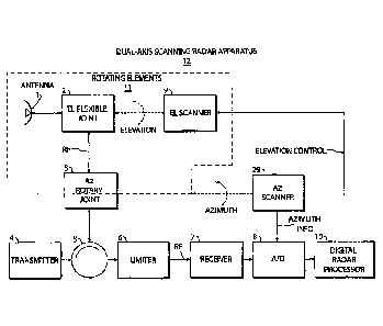
[0071] Figure 1 is a block diagram of a dual-axis scanning avian radar
apparatus in
accordance with the first part of the present invention.
[0072] Figure 2 illustrates a cylindrical volume scanning method and dual-
axis
scanning apparatus in accordance with the present invention.
[0073] Figure 3 is a block diagram of an Avian Track Interpretation
apparatus in
accordance with the second part of the present invention.
[0074] Figure 4 shows a preferred embodiment of the Avian Track
Interpretation
apparatus in accordance with the present invention.
[0075] Figure 5 is a block diagram of a network of 3D Avian Sampling
Radar
Apparatuses (the operatively connected avian radar and track
interpreter systems), along with its connections to the environment and
to end-users.
[0076] Figure 6 is a block diagram of a preferred embodiment of a 3D
Avian Sampling
Radar Network in accordance with the present invention.
[0077] Figure 7 shows an example of the structure of avian activity
report in
accordance with the present invention.
[0078] Figure 8 shows an example of an avian activity report result and
user interface
in accordance with the present invention.
DEFINITIONS
[0079] The terms "volume-scanning radar device," "volume-scanning radar
system," "3D
scanning radar device," and "3D scanning radar system" are used herein to
denote a type of
radar apparatus with a structure and associated scanning protocol that
produces a periodic
sampling of a large volume such as a cylindrical area of 20 kilometers in
diameter and 10,000
feet in altitude. Such a volume-scanning radar apparatus enables, for
instance, the tracking of
significant numbers of birds about an airport, an oil sands area, a
conservation preserve, etc.
- 21 -
Date Recue/Date Received 2022-04-28
A volumetric scan pursuant to the invention may be achieved by executing
multiple scans
along one coordinate direction for each single scan along another coordinate
direction. For
instance, multiple azimuthal scans may be carried out for each single
elevational pass.
[0080] Concomitantly, the twit "3D volume" is used herein to denote volume
on the
order of kilometers or more in diameter or width and thousands of feet or more
in height. A
3D volume typically defines the airspace about a facility of importance, such
as an airport, a
nuclear or other power plant, a dam, an oil field, a marine terminal, etc.
100811 The term "track database" is used herein to denote a database that
stores temporal
and spatial information about detected targets. A track database as that term
is used herein is
a key part of a radar data server and a geographical data server. As used
herein, a radar data
server and a geographic data server may each have their own track database, or
they may
share parts of a common database. The context will indicate whether the term
track database
refers to that specific part of the radar data server or geographic data
server, or the combined
target database.
100821 The term "radar data server" is used herein to denote a server
computer in a
networked radar system that organizes and stores time-ordered track data
pertaining to
multiple target objects in a surveillance volume over an extended period of
time. A radar
data server, as that teitn is
100831 used herein, enables the efficient provision in real-time and for
historical access of
track data pertaining to the multiple target objects in a time-ordered manner.
A radar data
server is preferably connected to a geographical data server and to multiple
users via an
interface and a computer network. A radar data server (RDS) thus performs
functions of
receiving target data (including track data, detection data, alerts and meta
data) from various
radars, storing the data in the track database, and serving the target data to
various users and
applications. A radar data server may be a single device serving an entire
network of 3D-
volume-scanning radars or may each represent a respective plurality of
respective track data
processing devices where each such device serves a particular one or more of
3D-volume-
scanning radars.
- 22 -
Date Recue/Date Received 2022-04-28
[0084] The term "geographical data server" is used herein to denote a
database,
preferably with data processing capability (hence "server"), that processes
radar time-ordered
track data, for instance, from a radar data server, to generate target-object
data which include
trajectory-ordered track data pertaining to respective target objects. The
target-object data is
spatial in that the trajectories extend in space with the time element either
eliminated or
reduced to secondary status, e.g., by indexing. The target-object data
preferably includes
other types of information, such as direction, speed, velocity (direction and
speed), target
cross-section (RCS), altitude, etc., in statistical attiibute format in easy-
to-search indexed or
tabular form. A geographical data server may be a single device serving an
entire network of
3D-volume-scanning radars or may each represent a respective plurality of
respective track
data processing devices where each such device serves a particular one or more
of 3D-
volume-scanning radars.
[0085] One use of the tem' "target" herein is to denote an object of
interest that is capable
of being detected and tracked via a radar tracking system. An alternative use
of the term
"target" denotes an object in the form of a collection of radar data as stored
in memory that
includes all of the location updates of an associated track in a single
structure upon which
geographical calculations can be easily carried out.
[0086] The term "on the fly" as used herein denotes in part a continual
processing of
radar track data to organize and reorganize that data into time-ordered track
data (in a radar
data server) and into spatial-ordered track data (in a geographical data
server). The term "on
the fly" refers to radar data processing operations that occur automatically
and continuously,
rather than sporadically and only in response to user requests. The time-
ordered and spatial-
ordered track data are stored in a track database as the organized and
reorganized data is
generated, thereby making that track data available on a continuing updating
basis to various
individual users and software applications. The organizing of the track data
may extend to
the computing of various statistics pertaining to different target-
characterizing parameters
such as position, altitude, speed, direction, velocity (speed and direction),
radar cross-section
(RCS), etc. The spatially ordered track data includes trajectories, that is,
complete
descriptions of target movement. The organizing of the track data may further
extend to the
computing of various statistics pertaining to target objects and their
associated trajectories.
The on-the-fly processing of radar data acquired during a scan of a radar
volume slice may
occur during the acquisition of radar data from a next volume slice scan.
- 23 -
Date Recue/Date Received 2022-04-28
[0087] The term "target analytics processor" (TAP) as used herein denotes
a processor
configured at least in part to selectively access temporally and spatially
ordered track data
(e.g., in a radar data server and a geographical data server, respectively) in
order to respond to
a query from a user for specialized radar infoimation or alternatively to
further process and
organize the track data, for instance, into statistical measures for
facilitating responses to
future inquiries from users. Thus, the target analytics processor analyzes
accessed track data
to further organize and process that data on the fly or in response to user
requests and to
generate activity reports which may be published on a Web server for Intranet
or Internet
access by users. The TAP may include Web server functions as well. A target
analytics
processor may be a single device serving an entire network of 3D-volume-
scanning radars or
may each represent a respective plurality of respective track data processing
devices where
each such device serves a particular one or more of 3D-volume-scanning radars.
[0088] An "avian activity illustrator" or, more generally, "airborne-target
activity
illustrator" as that temi is used herein refers to a software-configured
computer or processor
that, in response to user requests, accesses a track database and analyzes
track data to create
requested target activity reports. The activity illustrator may include Web
server
functionality for delivering the generated activity reports to the requesting
users, preferably
over a network connection. An activity illustrator may be an included portion
of a target
analytics processor. The latter includes additional functionality, for
instance, for computing
statistical values for target-characterizing parameters, independently of any
specific current
user requests but in anticipation of eventual need.
[0089] The terms "avian track interpretation engine" and "avian track
interpreter" and,
more generally, "airborne-target track interpretation engine" and "airborne-
target track
interpreter" are used herein to refer to the interconnected combination of an
avian or
airborne-target activity illustrator, a track database (including both time-
ordered and spatial-
ordered radar track data), and a user interface and control. The user
interface and control
fields incoming queries and requests for selected radar data from individual
users and user
applications programs. The track database of a track interpretation engine or
track interpreter
may include processing functionality, specifically as part of a radar data
server that generates
temporally ordered track data and a geographical data server that generates
spatially ordered
track data.
- 24 -
Date Recue/Date Received 2022-04-28
[0090] The terms "spatial-ordered data" and "spatially ordered
information" and
variations thereof are used herein to denote the structuring of radar data in
a radar database in
accordance with trajectories of target objects. Thus, information is coded or
organized by
track trajectory or target object so that a spatially ordered database rapidly
yields the
trajectories or cumulative successive locations of individual tracked objects.
This spatially
ordered information facilitates and expedites correlation of tracked objects
or targets with
predefined geographic regions or spatial grid areas. Spatially ordered data
may include time
markers, e.g., via indexing, that facilitate correlation with time-ordered
data in a temporal
database. A geographic data server (GDS) reorganizes scan-by-scan track data
on the fly,
into GIS-friendly track-oriented entries. Each track entry that is created
preferably contains a
globally unique track ID that identifies the track over all time and all
radars, and a
LINESTRING-type GIS object that contains the target's location in 3D space and
time over
the life of the track (i.e. its trajectory).
[0091] The terms "time-ordered data" and "temporally ordered information"
and
variations thereof are used herein to denote the structuring of radar data in
a radar database in
accordance with the times of the collection of the radar data. A temporally
ordered database
thus rapidly yields target parameters (location, speed, direction, velocity,
radar cross-section)
of the group of tracked objects detected together as a function of time. This
temporally
ordered information facilitates and expedites real-time awareness as well as
correlation of
tracked objects or targets with daily and seasonal times. Temporally ordered
data may
include space markers, e.g., via indexing, that facilitate correlation with
spatial-ordered data
in a spatially ordered database. As disclosed herein, a radar data server
records all processed
target track data on a scan-by-scan basis, that is, it is organized based on
timestamps that
increment on every scan by the radar antenna's azimuth rotational period. This
creates a time-
based organization of radar data.
[0092] The word "priority" in a term such as "priority coverage" or
"priority sub-
volume" is used herein to denote a sub-volume of a 3D volume that is
designated as of higher
importance for radar scanning purposes. A priority zone might be, for example,
an airport
take-off and landing corridor, or a known bird migration route over an oil
field or
conservation site. A radar installation capable of monitoring a 3D volume
about a sensitive
- 25 -
Date Recue/Date Received 2022-04-28
facility may be operated to concentrate radar detection on a priority zone
without totally
ignoring other parts of the 3D volume.
DETAILED DESCRIPTION
[0093] A block diagram of a dual-axis scanning avian radar apparatus 12
in accordance
with the first part of the present invention is shown in Figure 1.
Characteristics of each block
are as follows. The dual-axis scanning avian radar apparatus 12 includes a
radar transmitter 4
that can be of the noncoherent or coherent type, and transmits pulses
typically of constant
width at a constant pulse repetition frequency (PRF) at X-band or S-Band (or
other bands).
Radar apparatus 12 has a dual-axis scanning antenna 1. Antenna 1 is typically
mounted near
ground level within (or near) the area to be monitored.
[0094] The Az-scanner 29 and El-scanner 9 move the antenna 1 through its
(typically)
helical scan path using an Az-scan motor and an El-scan motor. The El
(Elevation) flexible
joint 2 and Az (Azimuth) rotary joint 3 allow RF transmission and reception
while scanning
on both axes. The circulator 5, limiter 6 and receiver 7 are conventional
radar components
such as those found in marine radar transceivers. The analog to digital (A/D)
converter 8
digitizes the radar return video signal. The Az-rotary joint 3 which includes
a slip ring
connection provides a path for RF, power and control for the El-scan motor,
while the
antenna 1, El flexible joint 2 and El-scan motor rotate in azimuth. The El
flexible joint could
also be of a rotary joint type.
[0095] A preferred cylindrical volume-scanning method with dual-axis
scanning
apparatus is illustrated in Figure 2, using a dual-axis scanning radar in
accordance with the
current invention. A volume scan is carried out by successively scanning the
beam 33 about
the azimuth axis, while stepping through a number of elevation angles, the
collection of
conical sub-volumes making up the required 3D surveillance volume. The scan
pattern is
repeated after the beam 33 steps through the collection elevation angles that
make up the scan
pattern, so that the entire volume scan repeats continuously. The time taken
to complete a
single volume scan is the volume scan period and volume scan revisit time.
[0096] At each elevation angle 32, the beam 33 covers an elevation swath
34 of width
equal to the antenna's beamwidth 35 centered at the angle 32. By rotating
about the azimuth
- 26 -
Date Recue/Date Received 2022-04-28
axis 36, the antenna illuminates a solid of revolution 37 that is the volume
between two cones
38 and 39. If the antenna is then tilted by the El-scan motor to a lower
elevation angle 40 by
rotation about the elevation axis 41, then the solid of revolution 42 is
illuminated. By
successively illuminating at other elevation angles, 43, the entire cylinder
is eventually
covered by the scan pattern. The cylindrical volume meets typical end-user
requirements for
coverage of airborne targets: from zero to a specified ground range R (e.g.
R=10 km) and
from 0 to a specified altitude H (e.g. H=10,000 ft) AGL.
[0097] With the volume-scanning method shown in Figure 2, illumination at
high
elevation angles (e.g. greater than 60 degrees) is not particularly useful and
can be dispensed
with in preferred embodiments in accordance with this invention. This is
because once the
beam hits the top of the cylinder, the volume of a given solid of revolution
rapidly decreases
with increasing elevation. A beam pointed at 30 degrees illuminates a volume
4.7 times as
large as one at 50 degrees and 16 times as large as one at 70 degrees. Thus
there are rapidly
diminishing returns in coverage volume versus scanning time at higher angles.
Not
illuminating the high elevations allows relatively short volume revisits (e.g.
10 minutes)
while tracking nearly the full complement of birds for use in activity reports
(due to the fact
that the missing volume is a small percentage of the total volume coverage).
It is then
possible to generate hourly volume activity reports that update every 10 or 15
minutes.
Hourly reporting is important for tactical use at airports where wildlife
control personnel can
be dispatched to locations of significant activity in order to disperse birds,
reducing hazards
and increasing safety. A preferred volume scanning method embodiment for
efficient 3D
sampling only scans up to a middle elevation (e.g. 45 degrees), and sacrifices
the small cone
above the radar. The ratio of the volume of this small cone (a 45 deg cone has
a radius r = H,
and volume = pi/3(r2)H) to the entire cylindrical volume (volume = pi(R2)H)
can be shown to
be 1/3(H/R)2. For H=10,000' and R=10km, this translates to leaving out of the
cylinder just
3% of the volume!
[0098] A second reason for not using high-elevation angles is that
horizontally moving
targets such as birds and aircraft do not remain in the (high-elevation) sub-
volume for long
durations, since the horizontal width of the solid of revolution also rapidly
decreases with
increasing elevation. This property is easily seen in Figure 2 where beam 33
which has an
elevation angle equal to 0 deg (i.e. pointed horizontally) has a horizontal
width equal to the
radius of the cylinder. On the other hand, solid of revolution 37 has a much
smaller
- 27 -
Date Recue/Date Received 2022-04-28
horizontal width. When the elevation angle equals 90 deg, the horizontal width
is the
smallest and is simply equal to the physical extent spanned by the antenna
beamwidth 35.
[0099] A preferred embodiment of the present invention allows the volume
scan pattern
to be set in software by the operator, and then directed by the DRP 10.
Feedback may be
provided to the DRP after the antenna 1 has tilted to a requested angle.
Arbitrary volume
scan patterns can be used, including those that step up or down through a
monotonic set of
elevation angles (this minimizes the revisit time for a particular beam
elevation), or up and
down through a set of elevation angles (this minimizes jumps between
successive elevations
to enhance track continuity), before the scan pattern repeats. Any number of
elevation angles
can be specified in the volume scan pattern, with arbitrary spacing between
each elevation,
and an arbitrary amount of time at each elevation, preferably specified in
terms of number of
azimuth scans, spent at each elevation.
[0100] In accordance with a feature of the present invention, scan patterns
can be tailored
for targets of interest by matching the scan pattern to their expected
location and dynamics.
For example, fast targets at shorter ranges approaching the radar will be seen
by the radar to
have a fast increasing elevation rate, whereas the same targets moving away
from the radar
will have a decreasing elevation rate. At further ranges, the elevation rate
decreases. The
.. scan pattern can be matched to the expected targets of interest to ensure
that the 3D sampling
of the specified surveillance volume results in the highest probability of
tracking particular
targets of interest.
[0101] In accordance with another feature of the present invention, the
operator can select
a target track of interest generated by DRP 10, causing the repeating volume
scan pattern to
be interrupted, while the dual-axis scanning radar apparatus 12 points to the
selected target.
The target of interest will then be illuminated by the radar. Illumination of
the target of
interest can be indefinite, or for a finite time, after which the volume scan
pattern resumes. In
addition, since the DRP 10 is tracking the target of interest, a target
follower-mode can be
effected by the DRP 10 providing elevation control to the El scanner 9
directly based on the
estimated elevation angle of the target of interest. Another preferred
embodiment of the
present invention has another source external to the dual-axis scanning radar
apparatus 12
provide the scan pattern elevation angles on-the-fly. For example, in UAS
applications, the
on-board GPS location of the unmanned aerial system is continuously
communicated to the
- 28 -
Date Recue/Date Received 2022-04-28
ground-based pilot/controller who is flying the UAS, so that the UAS location
is always
known. A preferred embodiment of the current invention has the UAS GPS updates
sent to
and used by DRP 10 to provide elevation control to the El Scanner 9. This
allows the dual-
axis scanning radar apparatus 12 to follow the UAS, providing a continuous,
protective
surveillance volume around the UAS itself. All general aviation aircraft and
birds that may
potentially come into conflict with the UAS will be illuminated by the
continuously adjusted
solid of revolution that follows the UAS and hence tracked by the dual-axis
scanning radar
apparatus 12. This UAS-follower mode is affordable and ideal for a ground-
based sense and
avoid capability in support of UAS operations.
101021 DRP 10 preferably tags all detections in real-time with current
elevation angle
information so that detections and tracks can be represented in 3D radar
coordinates (range,
azimuth, elevation) and transfolined to earth coordinates (lat, Ion, altitude
or equivalent).
101031 A block diagram of an Avian Track Interpretation apparatus 16 (also
referred to as
avian track interpreter or interpretation engine) in accordance with the
second part of the
present invention is shown in Figure 3. Characteristics of each block are as
follows. The
Track Database 14 internally stores target track information it receives from
the Volume
Scanning Radar apparatus 30 preferably over a network connection. The Volume
Scanning
Radar apparatus 30 is preferably a dual-axis scanning apparatus 12 but can be
any scanning
apparatus that supports 3D sampling in accordance with the present invention.
Dual-axis
scanning apparatus 12 can be used anywhere for Volume Scanning Radar apparatus
30
herein. The User-Interface and Control module 13 receives and processes User
17 requests
and specifications for avian activity reports. It also converts these requests
into queries for the
Track Database 14 and into commands and specifications for the Avian Activity
Illustrator
15. In response to the queries, the Track Database 14 delivers filtered
subsets of the track data
appropriate for the generation of the specified activity reports. The Avian
Activity Illustrator
15 analyzes the obtained track data and creates the requested reports
according to
specifications provided through the User-Interface and Control module 13 and
delivers them
to the User 17 preferably over a network connection.
[0104] Certain Users 17 may preferably have privileges to request that
the user interface
and Control module 13 set the operational scanning mode of the Radar 30 (or
12), as well as
the operating mode of the Avian Track Interpreter 16. As described earlier,
the Radar 12 can
- 29 -
Date Recue/Date Received 2022-04-28
be set into continuous volume scanning mode whereby it repeats a defined 3D
volume scan
pattern over and over again. Alternatively, it can be commanded to illuminate
a particular
target of interest and even to follow a target of interest by updating its
beam position to keep
the target of interest illuminated. In accordance with the present invention,
the Avian Track
Interpreter 16 can generate an avian activity report in an interactive fashion
by user
command. It can also continuously generate hourly, daily, weekly, monthly, or
yearly
activity reports on-the-fly, preferably publishing the same on a web server
(which preferably
is part of the Avian Activity Illustrator 15) so users can simply click to a
web-page of
interest, and can easily refer back to previously published reports.
101051 Figure 4 shows a GIS-Based Avian Track Interpreter 44 which is a
preferred
embodiment of the Avian Track Interpretation engine 16 and can be used in
place of Avian
Track Interpretation engine 16 herein. The GIS-Based Avian Track Interpreter
44 includes a
radar data server (RDS) 21, a Geographic Data Server (GDS) 22, and a Target
Analytics
Processor (TAP) 23. The DRP 10 of Volume Scanning Radar 12 (or 30) writes to
RDS 21 in
real-time. RDS 21 writes to GDS 22 in real-time, which reorganizes track data
using
Geographical Information System (GIS) constructs to support efficient spatial
queries for
activity reports. The TAP 23 runs various queries (on RDS 21 and GDS 22) and
analytics on
the fly (or in response to User 17 requests) to generate activity reports
which are preferably
published on a Web server for Intranet or Internet access by users. The Web
server itself is
preferably part of the TAP 23.
101061 The GIS-based architecture of the Avian Track Interpreter 44 is
key to being able
to compute efficiently and deliver in a timely manner the avian activity
reports in accordance
with the present invention. Avian radars generate a wealth of target
information, including
track information which grows very quickly. The RDS 21 stores this data
efficiently but the
storage and organization is essentially time-ordered ¨ i.e. rows of tables
increment in time.
This design is necessary to efficiently support real-time access by multiple
users. However,
the present invention requires avian behavior and activity reports which
require a 3D spatial
representation to convey the required information to users. For example, we
are interested in
avian activity in various geographical sub-volumes such as a particular
aircraft take-off or
landing corridor. This requires geographical sorting and 3D intersections of
the bird
trajectories with user-defined sub-volumes. To complicate matters further,
these
computations need to be carried out over a variety of time scales, from
minutes, to hours, to
- 30 -
Date Recue/Date Received 2022-04-28
days, weeks and even months. And once a particular data set is extracted,
various, user-based
filtering (as described below) requires additional computational effort and
must be responsive
to be useful. Unless the data is re-organized to account for both spatial and
temporal aspects
of the problem, and a divide-and-conquer approach is taken by computing
various statistics
on the fly so they are available to support queries when needed, the avian
activity reports in
accordance with this invention will not be practical. The RDS 21 and GDS 22
combination
achieve this at the cost of essentially doubling the storage requirements of
the Track Database
14 and increasing its computational capabilities. The GDS 22 results in a
duplicate of track
data re-organized with additional statistical elements as described earlier
and further below.
Queries in support of avian activity reports are distributed across the RDS 21
and GDS 22 as
appropriate, for efficiency, with temporal aspects preferring the RDS 21 and
spatial aspects
preferring GDS 22. Preferably, both the RDS 21 and GDS 22 are implemented on
high-
transaction rate relational database management systems with GIS extensions
and
functionality exploited in the design of the GDS 22, its track data
reorganizations, and in the
execution of spatial and geographic SQL queries to exploit inherent
computational
efficiencies.
[0107] DRP 10, RDS 21, GDS 22, TAP 23, User-Interface and Control 13 and
User 17
are preferably all part of computer network so they can communicate with each
other. The
computer network can be any combination of local area networks (LAN) and wide-
area
networks (WAN), including private and public networks such as the Internet.
Network
linkages can be wired (e.g. CATS, CAT6, fibre) or wireless (e.g.WiFi,
cellular, microwave
point-to-point, SATCOM) and preferably run open and standard network protocols
including
TCP/IP, HTTP, HTTPS, web services, et cetera.
101081 A block diagram of a 3D Avian Sampling Radar System incorporated
into an
Avian Radar Network 20 in accordance with the present invention is shown in
Figure 5. The
Network 20 comprises one or more Volume Scanning Radars 30 connected to one or
more
Avian Track Interpreters 16. The Radars 30 sense bird targets in the Physical
World 19 via
transmission and reception of RF pulses. The Avian Track Interpreters 16
receive requests for
reports from various Users 17 and deliver them to various entities in the
Information World
18 preferably over a computer or data network. Volume Scanning Radars 30 and
Avian
Track Interpreters 16 are preferably connected over one or more computer
networks as
- 31 -
Date Recue/Date Received 2022-04-28
described earlier. Each Avian Track Interpreter 16 may be dedicated to a
particular Volume
Scanning Radar 30, or it may serve multiple Volume Scanning Radars 30.
[0109] Figure 6 provides an illustration of a preferred embodiment of the
present
invention. A network of one or more dual-axis scanning radars 12 are
integrated into a 3D
Avian Sampling Radar Network 60. Each dual-axis scanning radar 12 consists of
a radar
transceiver 50, that is preferably a marine radar transceiver, a DRP 10, and a
dual-axis
scanning dish antenna 1 whose elevation angle is controlled by the DRP 10.
These volume
scanning radars 12 send their target tracks over a TCP/IP network to an RDS 21
and GDS 22
where they are organized in real-time for subsequent activity report queries
and
computations. A TAP 23 runs queries on the RDS 21 and GDS 22 on-the-fly in
response to
User 17 requests, and generates and publishes avian behavior and activity
reports for use by
operators or users 17. RDS 21, GDS 22 and TAP 23 may be respectively single
devices
serving the entire network of dual-axis scanning radars 12, or they may each
represent a
respective plurality of respective devices where each one of such devices
serves a particular
one or more of the dual-axis scanning radars 12. Operators/users 17 can be
anywhere on the
network and use a computer 51 or mobile device 52 to interact with the 3D
Avian Sampling
Radar Network 60. The network of course includes the Internet.
[0110] The dual-axis radar scanners 12 of Figure 6 may comprise at least
two radar
subsystems proximate to one another. The dual-axis scanning radars 12 may be
operated so
that each radar subsystem 12 illuminates a different sub-volume of a
predetermined 3D target
volume. The dual-axis radar scanners 12 may be operated side-by-side at
different fixed
elevation angles. Alternatively, the dual-axis radar scanners 12 may be
operated side-by-side
at different fixed azimuth angles. In another alternative operating
configuration, one of the
radar scanners 12 is operated as one or more 2D azimuth-rotating single-beam
radar systems,
while the other radar scanner 12 is operated as one or more 2D elevation-
rotating single-beam
radar systems.
[0111] A pictorial representation of a Map-Based Avian Activity Report 75
is shown in
Figure 7. The Background Map Layer 71 displays topographical features
underneath the
surveillance volume. Displayed on top of the Map 71 is the Avian Activity
Layer 72, which
depicts information about bird activity at the respective locations depicted
by the Background
Map Layer 71. The Avian Activity Layer 72 is divided into a grid of preferably
square
- 32 -
Date Recue/Date Received 2022-04-28
Resolution Cells 73, and the information depicted for a given cell comprises
the composite
avian activity in the surveillance volume above the area covered by the cell.
The activity
information is depicted on the Avian Activity Layer 72 by methods known to
those skilled in
the art, including color shading, the overlay of symbols of varying size,
shape and orientation,
etc. The grid size of the Resolution Cells 73 is usually selected for a given
aerodrome to
reflect the size of the aerodrome. For example, a 50 x 50 grid covering a 10
km by 10 km
airfield would result in 200m by 200m grid cells.
[0112] In accordance with the present invention, the bird attributes that
can be presented
in activity reports include, but are not limited to:
1. Geographic Location
2. Altitude
3. Abundance
4. Speed
5. Heading
6. Velocity
7. RCS (radar cross section)
8. Date and Time
9. Track Length or Duration
[0113] Each of these attributes can also be used for filtering
(selecting) the bird tracks
used in creating a given report. For example, only bird tracks with speeds
above a user-
specified minimum speed could be used in a report showing bird abundance or
behavior via
one or more of the other attributes. Typically, statistics of one bird
attribute (e.g. altitude) will
be "plotted" versus another attribute (e.g. location) while being filtered by
still another
attribute (e.g. time). Activity reports can be represented on a grid such as
shown in Figure 7
and Figure 8. In addition to abundance, density can be calculated and
represented along a
particular line, row or column of the spatial grid. Whereas abundance reports
the total
number of birds observed, density reports it in terms of a rate, including
numbers per unit
time or area.
[0114] In accordance with the present invention, the forms of activity
reports include, but
are not limited to, combinations of:
1. Text
- 33 -
Date Recue/Date Received 2022-04-28
2. Charts
3. Graphs
4. Tables
5. Images or Drawings (2D and 3D)
6. Any combination of Colors, Shadings, Patterns, Contours, Lines, Arrows,
Symbols,
Numbers, Text, 3D shapes, all of these possibly varying in size and
orientation, overlaid
on a Background Map
[0115] In accordance with the present invention, the bird attribute
statistics that can be
presented in activity reports include, but are not limited to:
1. Mean
2. Median
3. Maximum
4. Minimum
5. Variance or Standard Deviation
6. Histogram
7. Number (Count)
8. Density
9. Track Trajectories (Histories)
[0116] Figure 8 illustrates a real-activity report generated in
accordance with the present
invention. A User-Interface and Control 13 is shown that runs in a Web browser
and
interacts with a TAP 23. A time interval is specified for the activity report,
and the attribute
to display is selected as altitude. The maximum altitude is the statistic used
to calculate the
altitude spatial distribution over a 20x20 grid which is overlaid onto a local
map. Various
additional filters, settings, tools and information are available/controllable
through the user
interface.
[0117] To illustrate the advantages of our preferred GIS-Based Avian
Track Interpreter
44 and the need for the RDS 21 and GDS 22 combination, consider the following
example.
An hourly activity report (updated every 15 minutes) is desired that displays
abundance
information on a user-defined grid overlaid on the aerodrome. For each grid
cell, the number
of birds that flew over the cell's location in the past hour is computed and
represented as a
color on an image as illustrated in Figure 8. Hot spots around the aerodrome
will be readily
- 34 -
Date Recue/Date Received 2022-04-28
recognized by operators who can direct response personnel when needed. In
addition to the
grid-based, spatial activity report, a total abundance versus time line graph
is also desired,
quantifying the total number of birds tracked over the aerodrome in the last
hour and updated
every 15 minutes. Let's examine the calculations needed to compute these
activity reports.
With an avian radar horizontally rotating at 24 RPM, 1440 scans will occur
each hour. If a
bird is present and tracked for the whole hour (e.g. a turkey vulture riding
on thermals), its
track could have as many as 1440 time updates. If a 50x50 grid is used, 2,500
grid cells are
involved. Now the RDS 21 is time organized, listing for each of the 1440 scans
(or update
times) the track location update for each tracked bird, along with its track-
ID. Imagine 100
birds are being tracked at any given time, and on average, each bird spends 5
minutes in the
surveillance volume around the aerodrome. Assume that each bird is illuminated
for an
average of 1 minute during the volume scanning and hence each track has an
average of 24
updates. As a result, (60/5)*100-1,200 unique birds will be tracked in each
hour on average,
with 28,800 track updates. The GDS 22, on the other hand, is updated on the
fly and
organized by targets with each target represented by a track from the RDS 21.
Targets are
objects that contain all of the location updates of the associated track in a
single structure
upon which geographical calculations can be easily carried out. If the RDS 21
is used to
generate the total abundance versus time line graph, 1440 scans will need to
be searched for
each 1-hour period every 15-minutes to determine the number of unique track-
IDs which
represents the number of unique birds. If any target attribute filtering is
further requested by
the user (e.g. filter the line graph to include only those birds flying higher
than 200' AGL),
then 28,800 track updates will have to tested against the filter and the
number of remaining
unique track-IDs re-determined! In generating the grid-based spatial activity
report, the
computational requirements get completely out of hand if the RDS 21 is used.
Each of the
28,800 track updates would have to be tested against each of the 2,500 grid
cells (72,000,000
tests!) to determine if a given track-update crossed a particular cell. Then,
for each group of
updates crossing a particular cell, the number of unique track-IDs would re-
determined to
provide the abundance count. On the other hand, if the GDS 22 is used for
these activity
reports, the total abundance versus time line graph is easily generated simply
by looking at
the number of track objects generated during that hour. This information is
readily available
to the GDS 22 because it is organized by track objects to which are included
attributes such
as start and end time of the track, along with various other statistic metrics
described earlier.
In addition, once a group of track objects is selected (i.e. all those 1,200
track objects or birds
from the last hour), efficient geographical operations can be applied against
the geographical
- 35 -
Date Recue/Date Received 2022-04-28
grid (using built-in GIS extensions associated with the GDS) to generate the
required matrix
of intersections of track objects and grid cells.
[0118] The frequency-scanning apparatus is an alternative elevation beam
scanning
system that could be used in the volume scanning radar 30, where tuning of the
transceiver
RF scans the beam in elevation, giving continuously selectable beam positions.
The apparatus
employs a flat-panel frequency-scanned phased-array antenna. Such an antenna
delivers
phased-array performance without the need for phase shifters, at much reduced
cost. Lower
sidelobes (than typical reflectors) can be achieved by careful design of the
aperture taper. The
radar transmitter and receiver must be rapidly tunable over a fairly wide
bandwidth, which
prevents the apparatus from using inexpensive COTS marine radars.
[0119] An alternative to a single volume scanning radar 30 consists of
two (or more)
side-by-side avian radars, where one radar subsystem operates at a lower
elevation angle, the
other radar subsystem at higher one. Each radar subsystem has its own
receiver, AID and
processor. Tracks are combined in the avian track interpreter 16, which then
creates the avian
activity reports.
[0120] In complex applications, where both real-time monitoring and 3D
sampling are
required, preferred embodiments of obtaining the 3D surveillance volume in
accordance with
the present invention are as follows:
i) Use one agile, dual-axis scanning radar 12 with dish antenna;
ii) Use a non-agile dish (or array) plus an agile, dual-axis scanning radar 12
with dish
antenna;
iii) Use two agile, dual-axis scanning radars 12 each with dish
[0121] Each of the above volume scanning systems can be mounted on a
trailer for
mobility if needed. The non-agile antenna in (ii) can be used to provide
dedicated, continuous
coverage over a priority zone such as the take-off and landing corridors of a
runway. The
agile antenna, on the other hand, can be used in a multi-function role,
providing, at various
times:
a) cylindrical sampling to increase situational awareness everywhere;
b) additional priority coverage to the non-agile antenna during the day; and
sample other
sub-volumes at night for migration for example;
- 36 -
Date Recue/Date Received 2022-04-28
c) a larger coverage volume than a fixed dish could on its own, and providing
better altitude
estimates and improved RCS estimates by in accordance with US Patent No.
7,864,103 by
scanning through targets in elevation and employing centroiding and
interpolation
techniques;
d) a follower mode on a designated target of interest (requires feedback or
independent
location updates as described earlier herein); in follower mode, we get longer
tracks on
target of interest, additional data such as a full RCS profile; we can provide
protective
search volume around an unmanned aerial system (UAS) detecting general
aviation aircraft
in its vicinity for sense and avoid applications.
101221 When two agile, dual-axis scanning radars 12 are available,
maximum flexibility
is afforded to serve both real-time monitoring and 3D sampling without
compromise. For
example, one agile radar can be set in real-time follower, providing sense and
avoid to protect
a UAS from immediate, hazardous general aviation aircraft and birds; while the
second agile
radar could be set in cylindrical sampling mode to provide tactical activity
reports and
enhanced situational awareness throughout the critical airspace in the
vicinity of the
aerodrome. These near-time activity reports capture persistent hazards or ones
that are
starting to build up - they give an early warning to operators so they can
react before an
immediate hazard is upon them. This combination of real-time tracking with
near-time
activity reports for situational awareness in critical airspaces represents a
significant
improvement in safety over the state-of-the-art.
101231 Other scanning alternatives are possible, but the above are more
suited to avian
radars, where 3600 azimuth coverage is usually required. One could scan
quickly
mechanically up-and-down (or around) in elevation while rotating slower in
azimuth on a
large turntable. One could scan in both dimensions in a back-and-forth raster
mode
(electronic, mechanical, or both). While a phased-array antenna could be
integrated into the
radar sensor of the present invention, it is not a preferred embodiment of the
present
invention due to the significantly higher cost anticipated for such an
antenna.
[0124] Preferably, embodiments of a volume-scanning radar system as
disclosed herein
aim to take advantage of standardized COTS technologies to the maximum extent
possible in
order to keep the system cost low and to provide for low life cycle costs
associated with
maintainability, upgrade ability and training. Preferably, COTS marine radars
are used as the
- 37 -
Date Recue/Date Received 2022-04-28
radar sensor in order to minimize sensor costs. The radar processor 10
incorporates
sophisticated algorithms and software that runs on COTS personal computers
(PC). Preferred
embodiments provide a low-cost, high-perfoimance, land-based radar sensor
designed for
avian radar applications. Preferred embodiments digitize the raw radar video
signal from the
marine radar receiver and use a PC-based radar processor with sophisticated
processing such
as the detection, tracking and display processing described in US Patent No.
7,940,206
entitled "Low-cost, High-performance Radar Networks,".
[0125] The radar processor 10 preferably incorporates a detection
processor and a track
processor. The detection processor performs radar signal processing functions
known to those
skilled in the art such as scan-conversion, clutter suppression through the
use of adaptive
clutter-map processing to remove ground and weather clutter, sector blanking
to suppress
detections and interference in regions that are not of interest, adaptive
thresholding such as
constant false alarm rate (CFAR) processing, and digital sensitivity time
control (STC). The
detection processor declares the presence and location of target plots
preferably on each radar
scan. The infoimation on each plot preferably includes time, range, azimuth,
elevation, and
amplitude. The track processor sorts the scan-to-scan time-series of plots
into either target
tracks or false alarms. The infoimation on each tracked target preferably
includes time and
estimated 3D spatial position, velocity, and RCS. A plot-to-track association
algorithm
provides means to resolve ambiguities produced by multiple targets, missed
detections, false
alarms, and maneuvering targets, whereas a track filtering algorithm provides
high quality
estimates of target dynamics for the association algorithms and for the
activity illustrator. The
track processor preferably uses a sophisticated plot-to-track association
algorithm called
Multiple Hypothesis Tracking (MHT) and preferably uses an advanced track-
filtering
algorithm called Interacting Multiple Model (IMM) filtering as described in US
Patent No.
7,940,206.
[0126] The volume scanning radar 30 provides continuous writing of target
data directly
to the track database 14. The track database 14 can reside locally on the
radar processor
computer, on another computer on the network, or on both. Track data can
easily be stored
continuously, 24/7, without stressing the storage capacity of a COTS PC. The
track database
14 is preferably also used for other foims of post-processing, for interaction
with external
geographical information systems (GIS) systems, for remote radar displays, for
support for
web services, and for further research and development. Track database 14
preferably can
- 38 -
Date Recue/Date Received 2022-04-28
also send real-time target data to display processors, which can display
tracks in real-time on
an operator's monitor or computer display.
[0127] With state-of-the-art avian radars, the target data can be
presented to end-users on
real-time displays. A background map is integrated with the display on which
is overlaid geo-
referenced radar data. With the volume scanning aspects of the current
invention, a preferred
addition to state-of-the-art avian radar real-time displays is to allow the
end-user to display
recent tracks with the altitude and other information encoded. The end-user
can select how
long a "memory" the display has, e.g. the last 30 minutes. This gives a time-
evolving up-to-
the-minute picture of the developing avian activity. Colors, text and/or
symbols can depict
attributes of the individual tracks (e.g. altitude, RCS). The tracks can be
displayed with lines
or arrows depicting their trajectories. Alternatively, user-specified
statistical summaries of
recent avian behavior can be displayed, in the same manner as map-based
activity reports.
The display effectively becomes a real-time version of an avian activity
report.
[0128] The present invention does not always have to be in a 3D volume
scanning mode.
It can be switched under user-control to continuously cover a certain sub-
volume. When
operating in a non-volume scanning mode, all of the displays, alerts and avian
activity reports
can still be available; the information they depict, while still being geo-
referenced in 3D
(latitude, longitude, altitude), will only apply to the sub-volume. In
particular, a system
outfitted with a non-volume-scanning radar can still use the second part of
the present
invention.
[0129] The track data produced by state-of-the-art avian radars contains
detailed (but
compact) behavior information on individual targets. For any given scenario,
these data can
be automatically tested for hazardous activity, in order to generate alerts.
Because the
information is detailed, alerts can reflect complex behavior, such as origins
and destinations
of birds, runway approaches, density, etc. Target detection, tracking and
hazard recognition
algorithms may be customized for specific hazards and scenarios. Alerts can
include an
audible alarm and display indication to an operator, or a transmitted message
to a remote end-
user. The low-bandwidth track and alert information can be easily sent to
central locations,
and directly to end-users, providing economical, effective monitoring.
Automated alerts may
be sent to remote end-users who require them. This enables the avian radar
system to run
unattended with end-users alerted only when necessary. Furthermore, track
displays can be
- 39 -
Date Recue/Date Received 2022-04-28
provided to remote end-users to give them a clear picture of the situation
when alerts arise.
The system can exploit COTS communication technology to provide such remote
alerts and
displays inexpensively. The present invention can preferably provide alerts,
whether it is in
3D volume scanning mode or not. The alerts can be tailored to account for the
3D
components of the track information. Alerts are, in effect, brief real-time
avian activity
reports.
101301 For some avian radar applications, one volume-scanning radar
sensor, or even
several independently operating radars may not be enough to provide a high-
perfounance,
composite picture covering the area of interest. For any single radar, there
are gaps in
coverage due to obstructions, and the area covered may not be a wide enough.
In accordance
with the present invention, one or more volume-scanning radars are preferably
connected to a
network to send their composite information to a common track database, which
can
preferably be accessed at a central monitoring station (CMS). The CMS
preferably has a
fusion processor that integrates and/or fuses the data from the multiple
sources. A common
avian track interpreter preferably creates composite avian activity reports
using data from
either the common track database or the fusion processor.
101311 Many of the aforementioned radar processor features as well as
features not
mentioned above are described in the articles Low-cost Radar Surveillance of
Inland
Waterways for Homeland Security Applications, Weber, P et al., 2004 IEEE Radar
Conference, April 26-29, 2004, Philadelphia, PA, and Affordable Avian Radar
Surveillance
,Vstems for Natural Resource Management and BASH Applications, Nohara, T J et
al, 2005
IEEE International Radar Conference, May 9-12, 2005, Arlington, VA and US
Patent No.
7,940,206.
101321 Particular features of our invention have been described herein.
However, simple
variations and extensions known to those skilled in the art are certainly
within the scope and
spirit of the present invention. This includes variations on integration of
the functional blocks
described herein. For example, the A/D module 8 could be integrated with the
processor 10
forming a single functional unit, without departing from the spirit of the
invention.
- 40 -
Date Recue/Date Received 2022-04-28