Note : Les descriptions sont présentées dans la langue officielle dans laquelle elles ont été soumises.
WO 2021/094740
PCT/GB2020/052860
- 1 -
Maritime Surveillance Radar
Technical Field
The present invention relates to Earth observation, and particularly to a
delay/Doppler
radar for maritime surveillance.
Background of invention
Maritime surveillance is high priority for security and defence agencies all
around the
world. A truly global maritime surveillance network requires the deployment of
a
ro constellation of radar satellites that can efficiently detect ships clay
and night and in all
weather conditions. The main issues with deploying such a constellation are
the overall
costs: payload, platform, launch, and ground segment. These costs are mostly
driven by
the needs of the payload in terms of size, mass, and power consumption.
The problems of carrying out maritime surveillance on a global scale include:
= the immensity of the area to cover - more than 3.6 x 10⁸ km2;
= the necessary low data latency ¨ typically less than i hour; and
= the required satellite revisit time ¨ typically less than 2-3 hours.
For low data latency and high revisit, a low Earth orbit (LEO) constellation
should
typically consist of more than 20 satellites in a polar orbit. Although
different users
may have slightly different needs, these numbers illustrate the challenges of
ocean
monitoring.
Global maritime surveillance is typically addressed by combining information
from
several systems, including optical, Synthetic Aperture Radar (SAR), and
Automatic
Identification System (AIS) spaceborne sensors. On-board MS technology is
typically
constrained to areas of the coast and is limited in range by the Earth's
curvature. SAR is
the most reliable payload for ship detection, offering all-weather day and
night
capabilities and large coverage. However, SAR instruments require big antennas
(at
least 3m) are bulky (typically over 200kg) and have high power consumption (at
least
ikW). These features result in significant costs that are then multiplied by
the required
number of satellites needed for global timeliness and coverage.
NovaSAR-S, for example, can operate for 2-4 minutes per orbit which results in
a duty
cycle of only 5% with >70% of the Earth's surface to be covered with a single
400km
CA 03158356 2022-5-13
WO 2021/094740
PCT/GB2020/052860
- 2 -
swath. In fact, assuming a constellation of 18 NovaSAR-S satellites, the mean
revisit
time would be of around two days. NovaSAR-S weights approximately 500kg, and a
constellation of 18 satellites would probably require no less than four to six
launches,
adding an important overhead to total mission. The revisit time is far away
from the
desired 3 hours of timeliness.
Short revisit times are essential to detect, track, and enable efficient
reaction against
illicit activities happening in short time frames. As a result, ultra-wide
swath coverage,
ideally by a low cost constellation of instruments, is necessary to
effectively monitor the
ro oceans. In order to achieve this, each instrument should be able to
image a wide swath
and be small and compact in size, lightweight and have low power consumption.
Current spaceborne SAR systems are far from meeting these requirements, making
current global maritime surveillance expensive, inefficient and ineffective.
Embodiments of the present invention aim to address these problems via a new
target
technique. The technique is able to measure the distance and angular position
of one or
more marine vessels within the entire illumination footprint from a single
radar pulse.
According to an aspect of the present invention, there is provided a maritime
radar
system comprising a transmitter, a receiver, and one or more processors
arranged to
provide range and azimuth discrimination of a detection area by performing a
delay/Doppler analysis of the echo of a single beam transmitted by the
transmitter and
received by the receiver.
The beam transmitted by the transmitter may comprise a signal modulated with a
pseudo random noise, PRN, sequence, and of a transmission duration which is at
least
as long as the round-trip time of the signal from the transmitter to the
detection area
back to the receiver.
The PRN sequence may be a binary code phase-coded into the transmitted beam,
which
results in a low cross-correlation.
The maritime radar system may be arranged to redirect the transmission beam
after
each transmission to reposition the detection area to enable multiple
observations of
the same target.
CA 03158356 2022-5-13
WO 2021/094740
PCT/GB2020/052860
- 3 -
The transmitter may be arranged to transmit a plurality of beams
simultaneously, to
widen the coverage area.
The maritime radar system may be arranged to identify the position and heading
of one
or more marine vessels in the target area.
The maritime radar system may be arranged to transmit a range-Doppler cell ID
of a
detected marine vessel to a ground station, representing a simplification in
the amount
of information to be communicated in comparison to conventional tracking
systems.
The one or more processors may be arranged to receive marine vessel position
information from an automatic identification system, AIS, used by one or more
marine
vessels, and to use the received position information for a particular marine
vessel to
verify range and azimuth information for a determined by the particular marine
vessel
by the one or more processors.
According to another aspect of the present invention, there is provided a
satellite
payload comprising a maritime radar system according to any one of the
preceding
claims.
Embodiments of the present invention are associated with significantly reduced
DC
power consumption, a reduced requirement on satellite downlink data rates, and
reduced antenna sizes with respect to conventional SAR systems, resulting in a
lightweight and highly efficient instrument.
Brief description of drawings
Embodiments of the present invention will be described by way of example only,
with
reference to the following drawings, of which:
Figure 1 illustrates a system employing a radar according to embodiments of
the
present invention;
Figure 2 illustrates the detection principle for the different target
positions within the
radar footprint of a radar platform of embodiments of the present invention;
Figure 3 illustrates the principle of radar coverage according to an
embodiment of the
present invention;
Figure 4 illustrates a comparison of a Woodward Ambiguity Function for
different
radar signal pulses;
CA 03158356 2022-5-13
WO 2021/094740
PCT/GB2020/052860
- 4 -
Figure 5 illustrates a comparison of ocean surface coverage of a constellation
of 18 LEO
satellites after one day; and
Figure 6 illustrates a radar according to embodiments of the present
invention.
Detailed Description
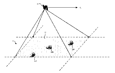
Figure 1 illustrates a system employing a radar according to embodiments of
the
present invention. The radar (not shown) is mounted in a payload 10 attached
to a
vehicle such as an aircraft or spacecraft, such as a drone or a satellite,
which travels
over a body of water such as an ocean ii, and the composite payload/vehicle
structure
io is referred to herein as a "radar platform".
On the surface of the ocean ii are one or more targets 12a-c, such as ships or
other
marine vessels or watercraft, to be detected by the radar. The radar is a
monostatic
system in which detection of a target is achieved based on analysis of a
signal
transmitted from the radar having being reflected back to the same radar as an
echo,
i.e. the transmitter and receiver of the radar are co-located in the
aircraft's payload 10.
The radar transmits a radio frequency (RF) microwave signal towards the ocean.
The
RF signal may be in a frequency band such as X-band, Ku-band or Ka-band. The
transmitted signal extends over a swath which has a coverage area or detection
area 13,
which is referred to herein as the "footprint" of the radar. The radar is able
to detect a
reflection of the transmitted signal by an object within the footprint 13. In
embodiments of the present invention, it is possible to provide range and
azimuth
discrimination of each ship 12a-c in the footprint 13 based on the
transmission of a
single pulse, as will be described below.
Consider the example of a target ship on the ocean surface ii. The radar is
mounted to a
satellite travelling at velocity vi, above the Earth's surface, wherein up is
significantly
greater (for example, of the order of 7km/s) than the speed of motion of the
ship across
the ocean. The radar operates on the Doppler shift principle, by which the
relative
velocity direction of the target affects the frequency of the transmitted
signal, so that
information about the ship's position can be derived from the frequency shift.
The angle of the transmitted signal, relative to the motion of the target,
affects the
frequency shift which is achieved. Generally, the Doppler frequency shift,fd,
of the
centroid of a reflection of a signal transmitted from a radar of wavelength 2
from
CA 03158356 2022-5-13
WO 2021/094740
PCT/GB2020/052860
- 5 -
a target having relative velocity v at angle Owith respect to the radar
transmission (the
direction of slant range) is given byfl = -(2v Pk.)* cosO.
Figure 2 illustrates the detection principle for the different target
positions within the
radar footprint of a radar platform of embodiments of the present invention.
A first target 21 is shown at a position which is below the radar platform 20,
such that
an incident signal reaches the target 21 in a direction perpendicular to the
relative
travel direction of the target 21. If the radar platform 20 travels with
velocity +vp, the
io target 21 can be considered to have a relative velocity of-vu, and an
angle of 0=900
relative to the transmission direction of the radar signal. Consequently,
there is zero
Doppler shift associated with the returned signal, in the absence of a
relative target
velocity component vt in the direction towards the radar platform 20.
A second target 22 is shown at a position "ahead" of the projection of the
radar
platform's position onto the ocean's surface. The target velocity vt is shown
towards the
radar platform 20, and vt = cos O. There is therefore a Doppler
shift of
fd = -(- 2z.7õ/2 cos 01, a positive shift since cos 9 is positive for oo < 9<
goo.
A third target 23 is shown at a position "behind" the projection of the radar
platform's
position onto the ocean's surface. The target velocity vt is shown towards the
radar
platform 20, having velocity -vp cos a. There is therefore a Doppler shift of
fd = -(-2vp/2 cos a), which is a negative shift since cos a is negative for
goo < a < 1800.
Accordingly, it is possible to determine the azimuth, 0, of the target
relative to the radar
platform 20 based on discrimination of the Doppler shift of a returned signal,
in
embodiments of the present invention.
The distance or "range" of the target from the radar platform 20 is determined
based on
measurement of the time delay between transmission of a signal by the radar
and
receipt of a reflected signal by the radar, since the signal velocity is
known.
The radar of embodiments of the present invention is thus able to employ what
is
referred to herein as a "delay/Doppler" method to determine both range and
azimuth
information for targets within the footprint 1,3.
CA 03158356 2022-5-13
WO 2021/094740
PCT/GB2020/052860
- 6 -
The radar of embodiments of the present invention has an advantage in that it
is
possible to determine range and azimuth information for all targets within the
footprint
13 of a single signal. This is made possible by the nature of the transmission
signal. The
radar of embodiments of the present invention transmits a single, long, pulse-
modulated signal with a Pseudo Random Noise (PRN) sequence or waveform. The
PRN
waveform has a small cross-correlation and may, in some embodiments, be a
binary
sequence known as a Gold code.
io In embodiments of the present invention, the "ones" and "zeros" of the
binary sequence
modulated a microwave carrier signal using binary phase shift keying (BPSK),
such that
the sequence is phase-coded into the carrier frequency.
Such a small cross-correlation makes it possible to discriminate easily
between
reflections of the signal by different targets. Frequency shifts associated
with azimuthal
measurements will lead to receipt of frequency-shifted versions of the
transmitted PRN
waveform which have no correlation with each other. The reflected signal, in
the
frequency domain, will have discrete peaks at different Doppler frequencies,
representing the azimuth of multiple targets.
In contrast, a SAR system is based on collection of signals from a number of
different
echoes as the radar moves over the area of interest, in order to increase the
effective
size of the radar. In order to do this, the transmission pulse is typically
short, in order
to increase the bandwidth of the radar, employing chirping techniques as known
in the
art. This improves distance resolution, but at the cost of poor Doppler
resolution.
Azimuth resolution is then achieved by combination of the different gathered
echoes.
In one embodiment, assuming LEO operation, where the radar platform 20 is at
an
altitude of the order of sookm, the radar transmits a pulse in the Ku-band for
approximately sms, and then receives for another sins. Depending of the
elevation
angle of the radar platform from the ocean surface ti, this will enable a
swath of a width
of approximately 25-45km to be covered, with azimuthal scanning range of
approximately tokm being covered as the radar platform moves in its orbit
above the
ocean surface it.
CA 03158356 2022-5-13
WO 2021/094740
PCT/GB2020/052860
- 7 -
In the context of the dimensions of the example above, in terms of the size of
the radar
footprint 13, the size of a target is negligible, and the target can be
regarded as a "point
scatterer", in which the reflected signal is modelled as reflection from a
single point of
no physical size.
After the loms period has passed, the operation is repeated with a new radar
beam,
which points to a different coverage area, such as an area is adjacent, in the
direction
substantially perpendicular to the direction of travel of the radar platform,
to that
covered by the previous signal. In one embodiment, 15 beams can be covered,
leading
io to a coverage area of up to 675krn.
In some embodiments, the radar platform is configured such that it is possible
to
perform both left-sided and right-sided looks, relative to the radar platform,
and
multiple looks can be performed for each radar beam. In the embodiment above,
30
beams can be covered where both left-sided and right-sided looks are used,
with more
than four looks per target in each case. This will then provide a total
combined swath of
more than 1000 km.
Figure 3 illustrates the principle of radar coverage according to an
embodiment of the
present invention. The radar is illustrated as mounted to a vehicle 30 which
is travelling
in the downward direction in the figure. The radar beam position moves from
the right
to the left of the figure, and as it does so, it illuminates a first
succession of coverage n
areas 31a, 31b, 31c,..., 31n via a sequence of transmission beams illustrated
with a slant
from upper right to lower left, before returning to the right most edge and
repeating the
scan from the updated position of the radar platform in a second pass,
illuminating a
second succession of n coverage areas 32a, 32b, 32c,..., 32n. As shown in
Figure 3, there
is overlap between the coverage areas of the first and second successions,
such that a
target in the overlap region can be observed twice as the radar platform
travels
overhead, improving detection capabilities.
In some embodiments, the duration of the transmission pulse may be
substantially
equal to the round-trip duration of the signal from the radar platform to the
target area
(the surface of the Earth, for example, the sea) and back to the transmitter.
In such
embodiments, the receiver and transmitter of the radar can be arranged as an
integrated transceiver, which switches mode from a transmitter to a receiver
at the end
of the duration of the transmission signal. This ensures that the full extent
of the
CA 03158356 2022-5-13
WO 2021/094740
PCT/GB2020/052860
- 8 -
transmission window is used of the transceiver, which maximises range and
azimuthal
resolution. In alternative embodiments, range and azimuthal resolution may be
increased yet further by employing a separate transmitter and a receiver in
the radar
platform, which allows longer transmission pulses to be used. The longer the
transmission pulse which is used, the smaller the antenna size that is
required, as the
size of the per-signal coverage area is increased.
The use of a PRN code enables high compression gains and good discrimination
of both
range and azimuth. Doppler discrimination capabilities are similar to those of
Jo unmodulated pulses, but in contrast, a rectangular unmodulated pulse,
for example,
offers very poor range resolution, for example mokm for a 5ms pulse. Chirp
waveforms, by contrast, offer excellent range resolution (for example, a im
slant range
for a 150MHz signal), but do not provide Doppler discrimination, as a time
shift is
introduced into the radar impulse response, and all targets of the antenna
footprint are
compressed with a single chirp replica, regardless of its Doppler properties.
Figure 4 illustrates the Woodward Ambiguity Function for a 5ms duration pulse
with
no modulation 40, chirp modulation 41, and PRN modulation 42 according to
embodiments of the present invention, which illustrates the principles above.
Embodiments of the present invention are not associated with range/azimuth
ambiguities since they operate on the basis of a single pulse
In embodiments of the present invention, the signal transmitted from the radar
platform has a frequency response represented by a main lobe centred on the
transmission frequency, with a number of smaller sidelobes symmetrically
positioned
either side of the main lobe in the frequency domain, with nulls between each
lobe. This
frequency response is typically of most antenna systems. The sidelobes can be
reduced
in relative size in embodiments of the present invention through the use of a
longer
PRN code pulse, but the optimisation of the side-lobe structure of the antenna
pattern
in elevation and azimuth is relaxed as the swath width is only limited by the
antenna
footprint and not by the diamond plot or the range/azimuth ambiguities
typically
constrained by the SAR pulse repetition frequency (PRF). This follows as
embodiments
of the present invention do not suffer from range/azimuth ambiguities since
they
operate on a single pulse basis. The specific PRN code to be used is
independent of the
transmission frequency of the signal.
CA 03158356 2022-5-13
WO 2021/094740
PCT/GB2020/052860
- 9 -
In some embodiments, it is possible to synchronise the output of the radar
platform of
embodiments of the present invention with an AIS. The information provided via
MS
may act as a means of verifying the accuracy of the output of embodiments of
the
present invention, from which a configuration or calibration routine, for
example, could
be performed. In such embodiments, the constraints on the resolution of the
radar can
be reduced, due to the availability of the supplementary information. In
addition, it is
possible to supplement the position and azimuthal output of the radar platform
with
information such as a vessel's ID or callsign, in order to enhance the
tracking
information provided.
Example configuration
An example of a satellite-based radar system according to an embodiment of the
present invention is specified by the parameters below (Table 1).
Parameter Value Parameter Value
Satellite Antenna
560 km 1 m
Height Length
Carrier Antenna
9.2 GHz m
Frequency Height
Chirp Azimuth
<50o MHz lo km
Bandwidth Coverage
Tx Peak Power 320 W Number of
beams
Pulse Duration 5 ms Losses 2 dB
Noise Figure 4 dB Ship RCS 29 dBm2
Table 1: Example specification of radar system
These system parameters provide up to four independent observations of a
single target
that have been multi-looked together and reported in the performance
estimation.
It will be appreciated that modifications to the parameters may be made in
dependence
on a required detection probability, and false alarm rate, at a particular
signal to noise
ratio (SNR) and signal to clutter ratio (SCR), in addition to resource
availability such as
power budget, transmission rates, constellation launch restrictions, and so
on.
Embodiments of the present invention are associated with at least the
following
advantages, in relation to reduced data latency, antenna size and power
consumption.
CA 03158356 2022-5-13
WO 2021/094740
PCT/GB2020/052860
- 10 -
Low Data Latency
Considering a spaceborne LEO scenario, the maximum pulse duration, assuming a
monostatic compact system, is limited by the pulse round-trip time. This is of
the order
of 5ms, and thus translates into a Doppler resolution cell of 200 Hz. The
Doppler
resolution can be then translated into ground resolution cell multiplying the
slant range
to the ship by the instantaneous azimuth beam-width which results, for the
200Hz
case, in approximately 300-400m.
With this in mind, the data processing can be done on-board by using a
technique
io similar to that used for delay-Doppler Map (DDM) generation in bistatic
Reflected
Global Navigation Satellite Systems (GNSS-R). The DDM's matched filter bank
can be
implemented in a Field-Programmable Gate Array and produce results in near
real-
time.
A ship detection algorithm is applied in some embodiments to the DDM,
reporting to
the ground only the cells with a positive detection. Only a few bytes per ship
will be sent
to the ground which will reduce the data to be downlinked quite significantly
with
respect to, e.g., SAR systems. All this makes possible a beyond line-of-sight
capability in
terms of sending data down to ground, and allowing for timeliness and
efficient data
provision to the end user.
Small Antenna Size
It is anticipated that the proposed radar antenna dimensions would be smaller
than im
x im. This is a significant reduction in the antenna area compared to the
smallest
antenna ever proposed for any spaceborne SAR mission; for comparison, the
NovaSAR-
S antenna measures 3m x im. There are two main factors contributing to this
miniaturisation: the single-pulse operation and the long transmitted pulses.
Transmitting/receiving a single pulse avoids range and azimuth ambiguities ¨
an
important problem related to antenna dimensions in SAR systems. In SAR, the
antenna
length is related to the range/azimuth ambiguities. The shorter the antenna,
the higher
the pulse repetition frequency (PRF) is needed to avoid aliasing of the
Doppler
spectrum. However, setting a high PRF results in an increase of the range
ambiguities
and reduces the attainable swath width. On the other hand, falling short of
PRF results
in an increase of the azimuth ambiguities.
CA 03158356 2022-5-13
WO 2021/094740
PCT/GB2020/052860
- 11 -
With the proposed radar single pulse operation, this problem does not apply
any more.
Small antennas are desired to increase the covered ground antenna footprint,
with the
power budget the only limitation for further shrinking the antenna size. Long
pulses
compensate for the loss in antenna directivity, balancing the power budget, as
below.
Lower Power consumption
The use of long pulses and the need of a single echo for ship detection
mapping result in
an extremely power-efficient instrument.
io The following assumptions have been considered when computing an
indicative DC
power consumption budget for a radar according to an embodiment of the present
invention:
= Radar Tx peak power = 320 W -> DC power consumption =4 x 320W = 1280W;
= 15 beams covered, revisiting each beam at least 4 times instrument duty
cycle
= 25%;
= Oceans cover the 70% of the Earth surface mean operational duty cycle;
= The radar back-end electronics (+RF elements) = woW.
This results in a preliminary average power budget of (128oW+ 100W) x 0.25 X
0.7 =
240W.
Table 2 presents an indicative power budget comparison between NovaSAR-S and
embodiments of the present invention. The antenna size and the wavelength are
quadratic contributions, the Radar Cross Section (RCS) of the ships are based
on actual
airborne campaign data at S-Band up-scaled to X-Band, and the number of
"Independent Observations" refer to the pulses integrated for azimuth focusing
in the
NovaSAR-S case and to the independent available observations using embodiments
of
the present invention. It will be appreciated that the final power difference
could be
optimised yet further by improving instrument losses, made possible because it
has a
simpler RF architecture, and considering that shorter slant ranges of
operation
compared to NovaSAR-S maritime mode.
CA 03158356 2022-5-13
WO 2021/094740
PCT/GB2020/052860
- 12 -
Parameter:
NovsSAR-S Embodiments Power
-
ot-õiremailit
DifferenceJor
Peak Tx Power 1.8 kW 320 W
-7.5 dB
Antenna Size 3m x im im x im
-9.5 dB
Wavelength 9 cm 3 cm
+9.5 dB
Ship RCS 20 dBM2 29.5 dBM2
+9.5 dB
Pulse Duration 0.2 MS 5 ms
+14 dB
Independent Observations 300 4 -19
clB
Total -3 dB
Table 2: Power budget comparison
Reduction of instrument data rate
As follows from the disclosure above, the radar of embodiments of the present
invention is not an imaging radar, but is a ship detection radar. As such, it
looks for
point targets over the oceans and, after detection of a ship, sends the
position to the
ground station(s). The amount of information to be downloaded can be
significantly
reduced if a simple cell ID identification number (related to a particular
range-Doppler
lo cell) is sent to the ground, together with the GPS time and the
satellite velocity and
position (PVT) when a ship(s) is detected_
In some embodiments, the on-board pre-processing consists in the generation of
Delay-
Doppler Maps (DDM) similar to GNSS-R and covering the whole antenna footprint.
Then, a ship detection algorithm will identify the cells in the DDM, e.g.,
above a
particular threshold (this is a simple approach just for illustration
purposes). Finally,
the detected cell IDs together with the time and position data can be
downloaded. The
actual position of the ships can be computed on-the-ground from the satellite
PVT and
cell ID information.
This technique allows a significant reduction in data rate. A NovaSAR-S
maritime
image (400 km x 400 km) requires a data volume of 13.7Gbits and produces a
data
throughput of 225Mbit/s. Assuming that in such area 200 ships are detected and
each
cell ID is coded with 32 bits, in comparison, a radar according to an
embodiment of the
present invention would have produced a data volume of 200 X 32 bits =
6.4kbits in
addition to the satellite position, velocity and time information.
Radars according to embodiments of the present invention are a wide-swath fit-
per-
purpose maritime surveillance radars that will be able to operate continuously
over the
CA 03158356 2022-5-13
WO 2021/094740
PCT/GB2020/052860
- 13 -
oceans with an estimated transmit peak power of only 320W and an antenna area
of
less than 1m2. The latter has an important impact on the instrument size/mass,
allowing for payload compactness and miniaturisation making it feasible to
operate on
micro-platforms such as OneWeb. Embodiments of the present invention enable a
payload mass of less than 50kg and average DC power consumption of less than
350W,
as set out above. Therefore, assuming a single-sided swath width of 500km, a
constellation of 18 payloads comprising radars according to embodiments of the
present invention could, for example, be packed in a single Soyuz launch and
offer a
mean revisit time better than 3h globally.
Comparison with other systems
In table 3 below, the performance of a LEO constellation consisting of 1.8
satellites is
presented based on three different payloads: Sentinel-i., NovaSAR-S, and
embodiments
of the present invention. The benefits of the proposed payload in terms of
coverage,
data downlink, and power together with a qualitative cost estimate are
presented.
. . .......... ........ .. ... ... .
SentineL-i NovaSAR-S of
present
......
Mode
Extra Wide
Maritime Mode Single Sided
, , , 400 km 400 km 500 km
. ... xxxxx.-
min/orbit 2-5 min/orbit
66.5 min/orbit
Peak Pkiikret : ' ' 4 kW 1.8 kW
320W
PRF l000 - 3000
Hz l000 - 1800 Hz <50 Hz
Iuise Duration <0.05 ms <0.2 MS
5 MS
,
, Mean Revisit Time <ioh 2 days <3h
LownIrnk : : : : = :::
520 mbit/s 500 Mbit/s Few
bytes/ship
Cost..... ::::::::::
Table 3: Performance comparison
20 Figure 5 shows the ocean surface coverage of a constellation of 18 LEO
satellites after
one day. In image 5o, NovaSAR-S payloads with current specifications are
considered,
i.e. 400km swath. In image 51, the equivalent case achieved with payloads
according to
embodiments of the present invention and 500km swaths are shown. There is a
significant increase in operational duty cycle from 5% to 70%. With
embodiments of the
25 present invention, the oceans are seen at least five to six times a day
around the
CA 03158356 2022- 5- 13
WO 2021/094740
PCT/GB2020/052860
- 14 -
Equator and more than 10 times at European latitudes. In the NovaSAR-S case
ocean
areas are not even imaged once a day.
Besides the advantages in terms of coverage, the payload according to
embodiments of
the present invention offer on-board pre-processing (Delay-Doppler Maps
generation)
and ship detection capabilities that will reduce the data downlink needs
orders of
magnitude compared to conventional SAR system. This is accomplished by the use
of
long pulses that avoid the conventional SAR azimuth focusing. Embodiments of
the
present invention only downloads a few bytes of information if a ship is
detected, in
ro contrast with SAR payloads that require wide-band downlinks, typically
¨500Mbps, to
provide raw data to the ground SAR processor. The latter introduces a
significant data
latency to conventional maritime SAR products.
Figure 6 illustrates a schematic of a radar 60 according to embodiments of the
present
invention.
The radar 60 comprises a central controller 61 which controls a
transmit/receive
(Tx/Rx) module 62 to transmit a signal to a coverage area 63, as described
above. The
transmit/receive module 62 may be part of an integrated transceiver, or may be
implemented as two embodiments. The transmitter and receiver components may be
implemented as a phased array antenna, operating under the control of a
beamformer
(not shown), and comprising analogue to digital circuitry, amplification and
noise
reduction circuitry (not shown).
The Tx module 62a operates to modulate a local oscillator signal at a
predetermined
microwave frequency with a PRN sequence stored in a memory (not shown). The Rx
module 62b operates to downconvert a received signal into an intermediate
frequency
for processing.
The downconverted signal is passed to a delay/Doppler Map analysis module 64
which
identifies targets within the coverage area on the basis of the Doppler shift
and range
analysis associated with the reflected signal at the receiver 62b. As
described above, the
DDM analysis module 64 may operate to generate a Delay-Doppler Map, as is
known in
the art. The DDM analysis module 64 is controlled by the central controller
62.
CA 03158356 2022-5-13
WO 2021/094740
PCT/GB2020/052860
-15 -
The output of the DDM analysis module 64 is a range and an azimuth in
measurement
for a target, plotted on a two-dimensional frame of reference. The output is
passed to a
correlator module 65 which correlates the output from the DDM analysis with
real-
world positions. For example, the correlator module 65 may receive mapping
information from a ground station link 66, which may be stored in radar
memory, such
that the two-dimensional range/azimuth data is correlated to geographical
position
information. The position determined in this manner is communicated to a
ground
station (which may or may not be the same ground station as that which
provided
mapping information) via the ground station link 66 to be processed by a user,
under
io the control of the controller 61.
In alternative embodiments, the correlator module 65 can be bypassed, and the
DDM
analysis module 64 can output a cell ID associated with the position of a
target, as
described above, and the correlation between the cell ID and the position can
be
performed at the ground station, based on position information associated with
the
radar 60. The radar position information may be determined by the radar
itself, or may
be provided to the controller 61 by the vehicle to which the radar 60 is
mounted, e.g.
the on-board controller of a satellite.
Any or each of the modules illustrated in Figure 6 may be implemented in
hardware, or
software, or a combination of the two, and components may be integrated as a
single
module, or separated into distinct modules.
It will be appreciated that a number of modifications to the described
technology, in
terms of the duration of a transmission signal, the nature of its low-
autocorrelation, the
nature of the transmitter and receiver arrays, and the specific nature of the
information
provided to the ground link as an output, in dependence on the intended
coverage area
and applications, provided the ability to provide range and azimuthal
distinction
resolution from single signal is preserved. For example, a satellite-based
radar platform
intended for continuous use may be configured differently from an aircraft-
based radar
platform intended to cover a more specifically-defined region for a particular
period of
time.
CA 03158356 2022-5-13