Note : Les descriptions sont présentées dans la langue officielle dans laquelle elles ont été soumises.
COMBINE HARVESTER OPERATION BASED ON WINDROW DATA STREAM
CROSS REFERENCE TO RELATED APPLICATIONS
This application claims the priority benefit of U.S. Provisional Patent
Application No.
63/277,779, filed November 10, 2021, entitled "COMBINE HARVESTER OPERATION
BASED ON WINDROW DATA STREAM," the entire contents of which are hereby
incorporated herein by reference.
BACKGROUND
[0001] A windrower (or a "swather") is a machine that cuts crops in a field
and forms
them into a windrow (or "swath"). The windrowed crops are then collected from
the field by
a combine harvester or other farm machine.
SUMMARY
[0003] In one embodiment, the invention provides a system for providing
machine
guidance to a combine harvester for a harvesting operation. The system
includes an electronic
controller configured to receive an input data stream from a windrower
including a
chronologically ordered series of location points each indicative of a
location of the
windrower at different times during the performance of a windrowing operation
in a field. A
plurality of data points from the input data stream are identified as
corresponding to a first
swath of crops cut by the windrower and left in the field during the
windrowing operation and
a centerline of the first swath is determined based on the plurality of data
points. Guidance
information to be used by the combine harvester during the harvesting
operation is then
generated based at least in part on the determined centerline of the first
swath. In some
implementations, the input data stream includes other operation data of the
windrower during
the windrowing operation including, for example, a chronologically ordered
series of ground
speed values, cutter bar lift values, and cutter bar speed values of the
windrower.
[0004] In some implementations, the guidance information is generated in
the form of a
path plan to be followed by the combine harvester while harvesting the crops
in the first swath.
1
Date Recue/Date Received 2022-09-09
In some implementations, the guidance information is used to assist an
operator of the
combine harvester during manual operation of the combine harvester. In some
implementations, the guidance information is used to facilitate autonomous or
semi-
autonomous operation of the combine harvester.
[0005] In another embodiment the invention provides a method of providing
machine
guidance to a combine harvester for a harvesting operation. An input data
stream is received
by an electronic controller from a windrower. The input data stream includes a
chronologically ordered series of location points each indicative of a
location of the
windrower at different times during the performance of a windrowing operation
in a field. A
plurality of data points from the input data stream are identified as
corresponding to a first
swath of crops cut by the windrower and left in the field during the
windrowing operation and
a centerline of the first swath is determined based on the plurality of data
points. Guidance
information to be used by the combine harvester during the harvesting
operation is then
generated based at least in part on the determined centerline of the first
swath.
[0006] Other aspects of the invention will become apparent by consideration
of the
detailed description and accompanying drawings.
BRIEF DESCRIPTION OF THE DRAWINGS
[0007] Fig. 1 is a perspective view of a windrower.
[0008] Fig. 2 is a block diagram of a control system for the windrower of
Fig. 1 in
communication with a control system for a combine harvester.
[0009] Fig. 3 is a perspective view of a field including multiple swaths of
crop cut by the
windrower of Fig. 1.
[0010] Fig. 4 is a flowchart of a method for recording operating data using
the control
system of Fig. 2 while operating the windrower of Fig. 1.
[0011] Fig. 5 is a flowchart of a method for converting stored operational
data from the
method of Fig. 4 into harvester path plan data useable by a combine harvester.
2
Date Recue/Date Received 2022-09-09
[0012] Fig. 6 is a flowchart of a method for providing operator assistance
to an operator
of a combine harvester based on the harvester path plan data generated by the
method of Fig. 5.
[0013] Fig. 7 is a flowchart of a method for autonomously operating a
combine harvester
based on the harvester path plan data generated by the method of Fig. 5.
[0014] Fig. 8 is a flowchart of a method for semi-autonomous operation of a
combine
harvester based on the harvester path plan data generated by the method of
Fig. 5.
DETAILED DESCRIPTION
[0015] Before any embodiments of the invention are explained in detail, it
is to be
understood that the invention is not limited in its application to the details
of construction and
the arrangement of components set forth in the following description or
illustrated in the
following drawings. The invention is capable of other embodiments and of being
practiced
or of being carried out in various ways.
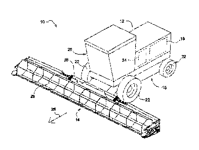
[0016] Fig. 1 illustrates an example of a self-propelled windrower 10. The
windrower 10
includes a tractor 12 and a work implement such as, for example, a header 14
coupled to the
tractor 12. In the example of Fig. 1, the header 14 is configured to cut crops
in a field (e.g.,
hay, small grain crops, etc.) and to leave the cut crop in swaths (or
"windrows") in the field
to dry. The tractor 12 includes a chassis 16, a prime mover 18, and a control
system 24. The
prime mover 18 is configured to move the tractor 12 in a direction of travel
25 via the ground
engaging devices 22. In the example of Fig. 1, the ground engaging devices 22
are wheels,
but tracks or other suitable ground engaging devices can be utilized in other
implementations.
The chassis 16 supports the prime mover 18 and the control system 24. The
prime mover 18
can include an engine (e.g., a diesel combustion engine) and the control
system 24 can include
a vehicle control unit (VCU).
[0017] The windrower 10 also includes an operator cab 20 positioned on the
tractor 12.
In some implementations, an operator of the windrower 10 sits within the
operator cab 20
while operating the windrower 10. Accordingly, in some implementations,
operator controls
(not pictured) are positioned within the operator cab 20 and may include, for
example, one or
3
Date Recue/Date Received 2022-09-09
more of a steering wheel, control levers, joysticks, control pedals, control
buttons, and other
input devices. The operator controls are configured to allow the operator to
control or alter
the operation of the windrower 10 (e.g., to control movement of the tractor 12
and/or operation
of the different components of the header 14) by actuating or adjusting one or
more of the
operator controls. One or more output devices may also be positioned within
the operator cab
20 for communicating information to the operator of the windrower 10 and may
include, for
example, one or more of a display screen, indicator lights, and audio
indicators.
[0018] In the example of Fig. 1, the header 14 includes a frame 26 and a
cutter bar 28
coupled to the frame 26 and operably coupled to the prime mover 18. The prime
mover 18
powers the cutter bar 28 to perform a cutting operation to cut crops in the
field (e.g., hay,
small grain crops, etc.). The header 14 is moveably connected to the chassis
16 by one or
more arms that are each pivotably coupled to the chassis 16 and/or pivotably
coupled to the
header 14. The header 14 is further coupled to the chassis 16 by a plurality
of actuators (not
pictured). The actuators are controllably operated to adjust a position and
orientation of the
header 14 relative to the chassis 16. In some implementations, the actuators
may include, for
example, hydraulic cylinders, pneumatic cylinders, electric motorized
actuators, mechanical
spring assemblies, and/or other actuators. In some implementations, the
actuators of the
windrower 10 includes a tilt cylinder actuator, one or more float cylinder
actuators, and a lift
cylinder actuator.
[0019] In some implementations, the tilt cylinder is configured as a single
double-acting
hydraulic tilt cylinder that extends or retracts to adjust a tilt angle of the
cutter bar 28 relative
to a ground surface on which the windrower 10 is positioned (e.g., the ground
surface of a
field). By controllably adjusting the tilt cylinder, the windrower 10 makes
refinements in a
cut height of the crop being cut. Specifically, actuation of the tilt cylinder
causes the cutter
bar 28 to pivot relative to the arms coupling the header 14 to the tractor 12
thereby raising or
lowering the height of the cutter bar 28.
[0020] In some implementations, the float cylinders are configured as
single-acting
hydraulic float cylinders that connect the chassis 16 of the tractor 12 to the
arms (i.e., the arms
coupling the header 14 to the tractor 12). The float cylinders at least
partially support a weight
4
Date Recue/Date Received 2022-09-09
of the header 14 and actuation of the float cylinders cause the arms to pivot
relative to the
chassis 16. By operating the float cylinders, the windrower 10 causes the
header 14 to follow
the ground surface over changing terrain. In some implementations, the lift
cylinder is a
separate component from the float cylinders and is configured to extend and/or
retract to lower
or raise the header 14 relative to the ground surface.
[0021] As the windrower 10 is operated in a field, the steering of the
tractor 12 may be
controllably adjusted to navigate the field. Also, the ground speed of the
tractor 12 may be
controllably adjusted to navigate the field and, in some implementations, the
adjust for
variations in crop density. For example, an operator may reduce the ground
speed of the
tractor 12 in areas with a high density of crops to ensure that the crops are
properly cut and,
conversely, may increase the grounds speed of the tractor 12 in areas with a
relatively low
density of crops. The actuators may also be operated (either automatically by
the control
system or manually by the operator of the windrower) to adjust the position
and/or orientation
of the cutter bar 28.
[0022] As the windrower 10 moves through the field, the cut crops are
deposited in rows
or swaths (called "windrows") in the field (see, e.g., Fig. 3 below). Each
swatch generally
follows a path travelled by the windrower 10 and, in some implementation, the
position of the
swath (i.e., a centerline of the swath) generally aligns with a known position
relative the
windrower 10. For example, in some implementations, the centerline of the
swath of crops
generally aligns with a centerline of the header 14. In some implementations,
the cut crops
are left to dry in the field before they are collected by a combine harvester
(not pictured). In
some implementations, the combine harvester collects the crops by generally
following each
swath (e.g., so that a center point of the path followed by the combine
harvester generally
aligns with a centerline of each swath).
[0023] Additionally, in some implementations, the combine harvester may
perform better
if the crops are fed into the combine harvester in a preferred direction. In
some
implementations, the direction travelled by the windrower 10 while cutting the
crop impacts
the direction/orientation in which the cut crops lay in the field and,
therefore, in some
implementations, it is preferable for the combine harvester to move in a
particular direction
Date Recue/Date Received 2022-09-09
relative to the forward direction 25 of the windrower 10. For example, in some
situations/implementations it may be preferable for the forward direction of
the combine
harvester to be same as the forward direction 25 of the windrower 10; in other
situations/implementations, it may be preferable for the forward direction of
the combine
harvester to be opposite the forward direction 25 of the windrower 10; and, in
still other
situations/implementations, it may be preferable for the forward direction of
the combine
harvester to be at an angle (e.g., perpendicular) to the forward direction 25
of the
windrower 10.
[0024] Fig. 2 illustrates an example of a control system for a windrower
(e.g., control
system 24 of the windrower 10) and a control system for a combine harvester. A
windrower
controller 201 includes an electronic processor 203 and a non-transitory
computer-readable
memory 205. The memory 205 is communicatively coupled to the electronic
processor 203
and is configured to store instructions that are accessed & executed by the
electronic processor
203 to provide the functionality of the windrower controller 201 including,
for example, the
functionality described herein. The windrower controller 201 is
communicatively coupled to
various actuators and sensors of the windrower including, for example, a
steering system 207,
one or more cutter lift actuators/sensors 209, a tractor vehicle speed sensor
211, and a cutter
speed sensor 213. The windrower controller 201 is also communicatively coupled
to a
positioning system 215 such as, for example, a GPS configured to determine a
position of the
windrower.
[0025] Similarly, a combine harvester controller 221 also includes an
electronic processor
223 and a non-transitory computer-readable memory 225. The memory 225 is
communicatively coupled to the electronic processor 223 and is configured to
store
instructions that are accessed & executed by the electronic processor 203 to
provide the
functionality of the combine harvester controller 221 including, for example,
the functionality
described herein. The combine harvester controller 221 is communicatively
coupled to
various actuators and sensors of the combine harvester including, for example,
a steering
system 227, one or more belt pick-up actuators 229 (e.g., for moving collected
crop along a
belt to a collection receptacle), and one or more drive train/vehicle speed
actuators 231 (e.g.,
6
Date Recue/Date Received 2022-09-09
for controlling and adjusting a ground speed of the combine harvester). The
combine
harvester controller 221 is also communicatively coupled to a positioning
system 233 such as,
for example, a GPS configured to determine a position of the combine
harvester.
[0026] In various implementations, the windrower controller 201 may be
configured to
operate the windrower by generating control signals to the various actuators
of the windrower
in response to operator inputs received by the windrower controller 201 (e.g.,
from the
operator controls positioned within the operator cab 20). Similarly, the
combine harvester
controller 221 may be configured to operate the combine harvester by
generating control
signals to the various actuators of the combine harvester based on operator
inputs received by
the combine harvester controller 221. In some implementations, the windrower
controller 201
and/or the combine harvester controller 221 may also be configured to provide
autonomous
and/or semi-autonomous operation of the windrower/combine harvester instead of
or in
addition to the manual operation. In some implementations, the windrower
controller 201
and/or the combine harvester controller 221 may be configured to provide
autonomous and/or
semi-autonomous operation in response to output data received from one or more
sensors,
image data captured by a camera system (not pictured), radar data from a radar
system of the
machine (not pictured), and/or a pre-determined path plan for moving the
windrower/combine
harvester through the field.
[0027] Additionally, in some implementations (as discussed further in the
example
below), the combine harvester controller 221 may be configured to receive data
indicative of
the operation of the windrower and to use that received data to provide
autonomous/semi-
autonomous operation of the combine harvester and/or to provide
guidance/assistance to an
operator of the combine harvester. Accordingly, in some implementations
(particularly
implementations configured manual or semi-autonomous operation of the combine
harvester),
the combine harvester controller 221 is communicatively coupled to one or more
operator
controls 237 such as, for example, a steering wheel, control levers,
joysticks, control pedals,
control buttons, and/or other input devices and is configured to generate
control signals to one
or more of the actuators in response to inputs received from the operator
controls. Similarly,
in some implementations, the combine harvester controller 221 is also
communicatively
7
Date Recue/Date Received 2022-09-09
coupled to a display screen 239 and is configured to display information such
as, for example,
information regarding the current harvesting operation, a path plan for the
harvesting
operation, and/or information regarding the windrowing operation performed
previously in
the same field.
[0028] In the example of Fig. 2, the windrower controller 201 is
communicative coupled
to a transceiver 217 of the windrower and the combine harvester controller 221
is
communicatively coupled to a transceiver 235 of the combine harvester. In some
implementations, the windrower controller 201 is configured to communicate
directly with
the combine harvester controller 221 by transmitting data from the transceiver
217 to the
transceiver 235 (e.g., through a wireless or wired communication mechanism).
In other
implementations, the windrower controller 201 is configured to transmit
collected data via the
transceiver 217 to a remote server 241 and the data is then transmitted from
the remote server
241 to the transceiver 235 of the combine harvester.
[0029] In some implementations, the windrower controller 201 is configured
to
periodically determine a position of the windrower and to collect other
information indicative
of the operation of the windrower as it moves through the field. For example,
in some
implementations, the windrower controller 201 is configured to periodically
collect a GPS
position, a ground speed, a cutter bar height, and a cutter bar speed at each
sampling interval
and to store the collected data to the memory 205. For example, Fig. 3
illustrates a field with
three swaths 301, 303, 305 of crop cut by a windrower. As discussed above, the
windrower
controller 201 periodically determined the GPS position of the windrower as it
moved through
the field and has stored at least 3 GPS positions 307, 309, 311 in the first
swath 301. Based
on this series of GPS position data, the windrower controller 201, the remote
server 241,
and/or the combine harvester controller 221 can estimate a centerline 313 of
the first swath.
Additionally, because the series of GPS position data points are acquired and
stored
sequentially, the windrower controller 201, the remote server 241, and/or the
combine
harvester controller 221 can also determine a direction travelled by the
windrower while
cutting each swath. For example, as illustrated in Fig. 3, it can be
determined that the
8
Date Recue/Date Received 2022-09-09
windrower was moving in a first direction 315 when cutting the second swath
303 and was
moving in an opposite direction 317 when cutting the third swath 305.
[0030] Accordingly, the operating data collected and stored by the
windrower controller
201 is transformed into a data format that is usable by the combine harvester.
As discussed
further in the examples below, in some implementations, the operating data
from the
windrower is used, for example, to generate a path plan (defining a route to
be followed by
the combine harvester when collecting the cut crops from the field), and/or a
windrow map
(defining the location and orientation of each swath in the field). In some
implementation,
the windrower controller 201 is configured to perform this data processing and
to transmit a
data stream that is already in a format usable by the combine harvester. In
other
implementations, the windrower controller 201 is configured to transmit a data
stream of raw
data to the combine harvester controller 221 (either directly or through the
remote server 241)
and the combine harvester controller 221 is configured to process the stream
of raw data in
order to generate the usable data for guiding the operation of the combine
harvester. In still
other implementations, the remote server 241 is be configured to receive the
raw data from
the windrower controller 201, transform the raw data stream into a data format
usable by the
combine harvester, and then transmit the transformed data to the combine
harvester
controller 221.
[0031] Although the example of Fig. 2 illustrate either direct
communication between the
windrower controller 201 & the combine harvester controller 221 (via
transceivers 217, 235)
or indirect communication through a remote server 241, in some implementations
other
mechanism may be utilized for facilitating the transfer of data and/or for
transforming the raw
windrower data stream into the data format usable by the combine harvester.
For example, in
some implementations, the windrower controller 201 may be configured to
transmit either the
raw data stream or the transformed data format to a cloud-computing system
where it is then
later accessed by the combine harvester controller 221. Alternatively or
additionally, in some
implementations, the remote server 241 in Fig. 2 may be replaced by a personal
computing
device (e.g., a laptop computer, a smart phone, or a tablet computer)
configured to transfer
data between the windrower controller 201 & the combine harvester controller
221 and/or to
9
Date Recue/Date Received 2022-09-09
transform the stream of raw data from the windrower controller 201 into the
data format usable
by the combine harvester controller 221. In still other implementations, the
windrower
controller 201 and the combine harvester controller 221 may each be configured
to be
communicatively coupled with a storage device (e.g. a thumb drive) that is
first coupled to the
windrower controller 201 to receive the data and is then coupled to the
combine harvester
controller 221 to transfer the data.
[0032] Fig. 4 illustrates an example of a method performed by the windrower
controller
201 for generating the data stream described above. After the windrowing
operation begins
(step 401), the windrower controller 201 monitors a periodic timer (step 403)
and, at a defined
sampling frequency, records the current GPS position of the windrower (step
405) and records
other operation data (step 407) (e.g., the ground speed of the windrower, the
height of the
cutter bar, and/or the cutter bar speed). The recorded data is stored to the
memory 205 of the
windrower controller 201 and, as the windrowing operation continues (step
411), new updated
data is recorded at the sampling frequency upon each expiration of the
periodic timer (step
403). In the example of Fig. 4, when the windrowing operation is complete
(step 409), the
stored recorded data is then transmitted to the remote server 241 or to the
combine harvester
controller 221 (step 413). However, as noted above, in other implementations,
the windrower
controller 201 may be configured to process and transform the recorded data
stream into a
data format usable by the combine harvester before transmitting the new
transformed data to
the remote server 241 or the combine harvester controller 221. Although, in
the example of
Fig. 4 the windrower controller 201 is configured to transmit the recorded
data after
completing the windrowing operation, in some implementations, the windrower
controller
201 is configured to transmit the recorded data throughout the windrowing
operation. For
example, in some implementations, the windrower controller 201 may be
configured to
periodically transmit new raw data each time a new GPS position and other
operation data is
recorded.
[0033] Fig. 5 illustrates an example of a method for transforming the raw
data collected
by the windrower controller 201 into a data format usable by the combine
harvester. In the
example of Fig. 5, the recorded windrow operation data is accessed (step 501)
and a harvester
Date Recue/Date Received 2022-09-09
path plan is automatically generated (step 503). A harvester path plan
includes a defined route
to be travelled by the combine harvester while harvesting the windrowed crops.
As also
discussed above, in some implementations, the harvester path plan is generated
by first
determining a location/centerline and windrower heading for each swath (e.g.,
as illustrated
in Fig. 3) and then determining a path plan for the combine harvester that
causes the combine
harvester to follow each swath in a preferred direction. Based on the raw data
collected by
the windrower, the path plan may also define, in some implementations,
variations in ground
speed, cutter bar height, and cutter bar speed to be applied at different
times and/or locations
as the combine harvester follows the route defined by the path plan.
[0034] As discussed above in reference to Fig. 2, in various different
implementations,
the data transformation performed in the method of Fig. 5 may be performed by
various
different computing systems and/or devices. For example, in some
implementations, be
performed by a remote computer server 241 that is configured to receive raw
data from the
windrower controller 201 and to then transmit the path plan data to the
combine harvester
controller 221. In other implementations, the windrower controller 201 itself
might be
configured to implement the method of Fig. 5 to generate the path plan data
for a combine
harvester before transmitting any data to the remote server 241 or to the
combine harvester
controller 221. Finally, in still other implementations, the combine harvester
controller 221
may be configured to receive the raw windrower data and to automatically
generate the path
plan according to the method of Fig. 5.
[0035] As also discussed above, the systems illustrated in Fig. 2 may be
configured to
facilitate manual operation of the combine harvester, autonomous operation of
the combine
harvester, and/or semi-autonomous operation of the combine harvester. Figs. 6
through 8
illustrate different examples of methods implemented by the combine harvester
controller 221
for manual operation (Fig. 6), autonomous operation (Fig. 7), and semi-
autonomous operation
(Fig. 8). These are only three examples and the specific methods for operating
the combine
harvester and/or for providing guidance and assistance to an operator of the
combine harvester
based on the raw data stream collected by the windrower may vary in other
implementations.
For example, in some implementations, certain steps described above in
reference to manual
11
Date Recue/Date Received 2022-09-09
operation of the combine harvester may be included in mechanisms for
autonomous or semi-
autonomous operation of the combiner harvester.
[0036] In the example of Fig. 6, the combine harvester controller 221 is
configured to use
the data collected by the windrower (or, for example, the harvester path plan
generated in the
example of Fig. 5) to provide guidance and assistance to a manual operator of
the combine
harvester. The combine harvester controller 221 accesses the harvester path
plan data (e.g.,
from the memory 225, from the remote server 241, and/or from the windrower
controller 201)
(step 601) and displays information associated with the path plan on an
operator interface
screen within an operator cab of the combine harvester (step 603). In some
implementations,
the information displayed on the operator interface screen may include data
similar to the
example of Fig. 3 in which the centerline for each of a plurality of swaths
are displayed along
with an indication of the direction to be followed by the combine harvester
along each swath.
[0037] The combine harvester controller 221 then continues to monitor the
operation of
the combine harvester (step 605) including, for example, periodically
monitoring the GPS
position, heading, and ground speed of the combine harvester as well as other
actuator settings
in order to determine whether the operator of the combine harvester is
following the defined
path plan (step 607). When the combine harvester controller 221 determines
that the
operator's manual operation of the combine harvester has deviated from the
defined path plan
(step 607), the combine harvester controller 221 updates the path plan (step
609) based, for
example, on the current position of the combine harvester and the previous
operation (e.g.,
route, speed, heading, & actuator settings) used by the combine harvester
during the current
harvesting operation. In this way, the path plan is updated to recommend an
optimized path
plan for completing the current harvesting operation.
[0038] Although, in the example of Fig. 6, the combiner harvester
controller 221 is
configured to update the path plan, in some implementations, the combine
harvester controller
221 may instead be configured to transmit a stream of raw data indicative of
the operation of
the combine harvester to the remote computer server 241 and the remote
computer server 241
is configured to update the path plan for the combine harvester based on the
raw data stream
12
Date Recue/Date Received 2022-09-09
from the combine harvester controller 221 and transmit the updated path plan
back to the
combiner harvester controller 221.
[0039] In the example of Fig. 7, the combine harvester controller 221 is
configured to
perform the harvesting operation completely autonomously based on the path
plan generated
by the method of Fig. 5. The combine harvester controller 221 accesses the
path plan data
(step 701) and autonomously controls the operation of the combine harvester
based on the
path plan including adjusting the steering, ground speed control, and other
actuator settings of
the combine harvester (step 705). In some implementations, the combine
harvester controller
221 may be configured to display path plan information and progress of the
combine harvester
in performing the harvesting operation on a display screen during the
harvesting operation. In
some implementations, the graphical information is displayed on a display
screen located
within an operator cab of the combine harvester and, in some implementations,
the graphical
information is displayed on a remotely located display screen (e.g., located
at a facility where
an operator monitors one or more autonomous machines).
[0040] In the example of Fig. 8, the combine harvester controller 221 is
configured to
provide semi-autonomous operation of the combine harvester during a harvesting
operation.
In particular, in this example, the operator of the combine harvester controls
the
driving/movement of the combine harvester from one swath to another and, once
the combine
harvester begins operating along a particular swath, the combine harvester
controller 221
provides auto-steering assistance to ensure that a combine harvester follows
the centerline of
each swath (within a defined tolerance) and also provides auto-adjustments to
other actuator
settings including, for example, ground speed and front-end equipment
actuators. Before
beginning the harvesting operation (step 803), the combine harvester
controller 221 receives
the harvester guidance data generated based on the raw data stream from the
windrower (e.g.,
the path plan generated in the example of Fig. 5) (step 801). The combine
harvester controller
221 then determines a current position and heading of the combine harvester
(step 805) while
displaying harvester assistance information (e.g., the windrow map and/or path
plan as
illustrated in the example of Fig. 3) on a display screen within the operator
cab of the combine
harvester (step 807).
13
Date Recue/Date Received 2022-09-09
[0041] Based on the path plan data and the determined current
position/heading of the
combine harvester, the combine harvester controller 221 determines whether the
combine
harvester is currently collecting crop by following a swath (step 809). If the
combine harvester
controller 221 determines that the combine harvester is not already operating
along a swath,
then the combine harvester controller 221 displays guidance to the operator
(e.g., graphically
on the display screen in the operator cab) instructing the operator to move
towards a
recommended swath to be collected next (step 811). In some implementations,
the combine
harvester controller 221 is configured to determine a recommended swath by
identifying the
swath that can be collected in the preferred collection heading with a
starting point nearest to
the current GPS position of the combine harvester. In some implementations,
the guidance
displayed on the screen may include a visual identification of the recommend
swath and
instructions (e.g., step-by-step driving directions) for moving the combine
harvester to the
starting point (e.g., an end of the swath) from the current GPS position of
the combine
harvester.
[0042] Once the combine harvester controller 221 determines that the
combine harvester
is operating along a swath, the combine harvester controller 221 compares a
current position
GPS position of the combine harvester to the position of the centerline of the
current swath
(step 813) and provides automatic steering adjustments (step 815) to ensure
that the travel of
the combine harvester is properly centered along the centerline of the swath
as determined by
the raw data collected by the windrower. Additionally, as noted above, the
windrower may
be operated to decrease its ground speed when the density of crops increases
and to increase
its ground speed in sections with a lower crop density. Accordingly, the path
plan (and thereby
the combine harvester controller 221) can estimate a density of cut crops at
locations along
each swath based in part on the recorded ground speed of the windrower at
those locations.
Therefore, in the example of Fig. 8, the combine harvester controller 221 is
configured to
identify deviations in windrower speed (step 817) and to automatically adjust
the ground
speed of the combine harvester and/or the front end equipment actuators in
order to more
appropriately collect larger/small relative densities of crops in the current
swath.
14
Date Recue/Date Received 2022-09-09
[0043] When the combine harvester finishes harvesting a particular swath,
the combine
harvester controller 221 determines that the combine harvester is no longer
operating along a
swath (step 809) and displays guidance directing the operator of the combine
harvester to the
next recommend swath. This is repeated until all of the cut crops in the field
have been
collected by the combine harvester.
[0044] In some implementations, the systems and methods described in the
examples
above are configured to collect and store data from a windrowing operating
that will then
serve as input data for a combine harvester. The collected data may include,
for example, a
windrow centerline (e.g., determined based on GPS position), a windrower
heading during the
cutting operation (used to determine the direction of the material as it lies
in the swath (e.g.,
swath orientation)), windrower speed, and lift position of the windrower
header. This
collected data is then passed to the combine harvester to be used as a
technology feature to
assist an operator of the combine harvester and/or to provide the ability for
the combine
harvester to operate autonomously (or semi-autonomously) when harvesting the
windrows.
In some implementations, this mechanism enables harvester autonomy for
windrowed crop
when an operator is not present in the operator cab of the combine harvester.
In some
implementations, this mechanism increases harvester productivity by providing
the machine
an optimized field traverse path that ensures the windrowed swath is always
being fed into the
machine in the preferred direction and feeding becomes more consistent as
centerline
guidance enables autosteer (as discussed further below) to ensure feeding is
always centered
on the belt pick-up ("BPU"). In some implementations, this mechanism creates
an additional
data stream between work operations in the small grain production system for
the customer
and the equipment manufacturer to use to make operational decisions. Finally,
without this
mechanism, an operator of the combine harvester may be required to visually
determine the
crop orientation in each swath and plan a field path (i.e., a path plan)
accordingly to keep the
combine harvester feeding in the desired direction. The operator must also be
vigilant in
making steering adjustments to keep the belt pick-up ("BPU") of the combine
harvester
centered on the middle of the swath to ensure even feeding. This requires an
experienced
operator with a sharp skillset to maximize productivity of the combine
harvester operation.
Accordingly, in some implementations, this mechanism ensures that a harvesting
operation
Date Recue/Date Received 2022-09-09
can be completed with greater precision and predictability even when the
combine harvester
is operated by a less experienced/skilled operator.
[0045]
Additionally, although the examples described above focus specifically on
using
operational data collected by a windrower to guide the later operation of a
combine harvester,
in some implementations, the systems and methods described above may be
adapted to other
combinations of machinery where data collected indicating the operation of one
machine is
then transformed into data usable by the other machine.
16
Date Recue/Date Received 2022-09-09