Note : Les descriptions sont présentées dans la langue officielle dans laquelle elles ont été soumises.
WO 2022/005298
PCT/N02021/050157
- 1 -
RESERVOIR FLUID MAPPING IN MATURE FIELDS
The present invention relates to the identification of viable hydrocarbon
reservoirs, particularly within mature fields.
Today, about two-thirds of the world's oil production comes from mature
fields. Whilst the term "mature field" has no single definition, it is
commonly
understood to refer to fields in which production has reached its peak and has
now
started to decline. Sometimes, a "mature field" is defined as one in which the
cumulative production has exceeded 50% of the initial 2P (proved plus
probable)
resources.
Often, highly deviated and horizontal production wells are used to extract oil
from mature reservoirs as the remaining oil reserves become difficult to
access
using vertical wells. Such wells can extract oil from a large area at
comparatively
low cost and can extend long distances horizontally, sometimes up to 10km, and
will pass through regions of the reservoir containing gases, such as gaseous
hydrocarbons or injection gas, as well as regions of the reservoir containing
liquid
hydrocarbons.
Although a good understanding of the initial reservoir fluid distribution is
obtained from early discovery and appraisal wells, the remaining oil
distribution in a
mature field is complicated after many years of production with measures like
depletion, gas and water injection. The remaining oils are often segmented and
comparatively expensive to recover. The key to production success in a mature
field is to accurately identify oil targets that can be recovered using cheap
wells,
whilst avoiding free gas.
4D seismic analysis is used widely in mature fields. This is a form of time-
lapse seismic analysis that comprises capturing 3D seismic survey data from a
field
at time-spaced intervals, often 6-month intervals, and examining changes in
the
data with time. Typically after the field has been in production for two or
more
years, sufficient seismic survey data will have been collected to allow for
useful 4D
seismic analysis to be carried out in order to track the changes in the
reservoir fluid
during production.
The use of multiple, time-spaced data sets also allows for a 3D model of the
fluid distribution within the reservoir to be produced by updating the initial
reservoir
fluid distribution model to account for changes over time. However, 4D seismic
interpretation does not provide quantitative reservoir fluid properties data,
but rather
CA 03184573 2022- 12- 29
WO 2022/005298
PCT/N02021/050157
- 2 -
a qualitative indication of fluid changes, caused by any one or more of
pressure
changes, density changes and saturation changes. Many assumptions must be
made to interpret what these changes mean (e.g. gas displacing oil, or water
displacing oil).
Furthermore, the practical vertical resolution of 4D seismic data is about 20-
30 meters. Where oil reserves are highly segmented, this resolution can bring
high
uncertainties, especially for vertically thin layers.
Petrophysical logs are used extensively to identify reservoir fluid types.
Density-neutron separation data presented in petrophysical logs can be
utilized to
distinguish oil and gas. However, density-neutron logs are responsive to both
lithology and reservoir fluids and therefore, there are uncertainties related
to the
interpretation from petrophysical logs based on such data.
Techniques such as sampling while drilling, downhole fluid sampling, and
downhole fluid analyser are not well suited to the horizontal production
wells, due to
the length of the wells and the fact that the wells are not oriented
vertically.
When the 4D seismic data shows "brightening" in an area, it usually
indicates a gas oil ratio (GOR) increase of reservoir fluids, assuming that
pressure
change is ruled out. However, due to the limitation of the 4D seismic
technology, it
has not previously been possible to accurately determine reservoir fluid
property
(e.g. GOR) in a particular reservoir layer.
It is undesirable to produce large quantities of free gas from an oil
reservoir,
such as solution gas or injection gas, because the unwanted production gas
will
typically be compressed and re-injected into the reservoir, which adds
significant
cost to the operation and leads to significant CO2 emission. Consequently,
"brightening" areas are often avoided when drilling new production wells.
Furthermore, even if a production well has been drilled in or near such a
"brightening" area, it is usually desirable to perforate only the oil zones so
that the
well can be completed at low cost.
Due to the limitations of current technology, it has been necessary to take a
conservative approach with reduced oil production and profitability in order
to
minimise the risk of a large gas breakthrough which might cost of the entire
production well.
A need exists for a new technology to more accurately identify the remaining
oil targets within a mature reservoir.
CA 03184573 2022- 12- 29
WO 2022/005298
PCT/N02021/050157
- 3 -
Viewed from a first aspect, the present invention provides a method
comprising:
identifying a region of interest within a hydrocarbon field based on a first
model of the field produced using 4D seismic data;
drilling a plurality of production wells through the region of interest,
wherein
mud-gas data is collected as each production well is drilled;
generating a refined model of at least the region of interest based on the 4D
seismic data and the mud-gas data, the refined model having less uncertain
reservoir fluid mapping and/or greater vertical resolution at the region of
interest
than the first model of the field.
Mud-gas logging is a technique in which hydrocarbon gas is released from
drilling mud at the surface and then examined. When drilling into the
reservoir, a
small quantity of the reservoir fluid will be carried in the drilling mud to
the surface.
At the surface, the drilling mud is processed to release a mixture of gases,
known
as "mud gas", which is then examined to estimate certain properties of the
reservoir.
At reservoir conditions, the reservoir fluid can be reservoir gas or reservoir
oil. Mud gas is principally comprises of light, gaseous fractions, which are
usually
from Ci to C5. Mud gas does not contain extensive information of oil
components,
which are usually 07 to C35+, and mud-gas data typically only comprises data
relating to composition of Ci to C5 hydrocarbons.
Mud-gas logging is commonly used when drilling exploration wells in new
fields in order to identify when a reservoir has been reached, for example to
determine the origin of reservoir fluids. Its use is less common when drilling
production wells in mature fields where the structure and the characteristics
of the
field is much better known from extensive data acquisition of early discovery
and
appraisal wells, 4D seismic survey, and production history from production
wells.
Recent developments in mud-gas analysis mean that it is now possible to
predict various reservoir fluid properties, such as gas-oil ratio, with a high
degree of
confidence based only on the Ci to C5 mud gas composition. This advantageously
allows for a substantially continuous logs of the reservoir fluid properties
to be
generated along the length of a well, but without the need to interrupt the
drilling
process, as might be required for sampling while drilling.
Mud-gas logging can produce a resolution of about 1 meter, which is much
greater than can be achieved using 4D seismic analysis, which typically has a
CA 03184573 2022- 12- 29
WO 2022/005298
PCT/N02021/050157
- 4 -
resolution of about 20-30 meters. Thus, by combining the fluid properties from
this
log through the region of interest with the 40 seismic data, it is possible to
improve
the resolution of the fluid mapping within the region of interest.
Additionally, the
mud-gas data can be used to refine the assumptions made when interpreting the
4D seismic data to provide a more accurate map of the reservoir fluid.
The hydrocarbon field may be a mature hydrocarbon field. The hydrocarbon
field may have undergone production for six or more months, optionally two or
more
years, and further optionally five or more years. The cumulative production of
the
hydrocarbon field may have exceeded 50% of the initial combined proven and
probable oil reserves within the hydrocarbon field.
The hydrocarbon field may have undergone gas injection. The region of
interest may comprise at least one gas-flooded reservoir.
The plurality of production wells may comprise at least one highly deviated
or horizontal production well. A highly deviated well may comprise at least
one
section oriented at an angle greater than 60 with respect to vertical. A
horizontal
well may comprise at least one section oriented at an angle greater than 80
with
respect to vertical, and preferably oriented substantially horizontally.
Highly
deviated and horizontal wells can be particularly important for mature wells
in which
the remaining oil reserves may become difficult to access using vertical
wells.
The fluid type within the region of interest may be uncertain based on the
first model. For example, the first model may indicate the probable presence
of free
gas within the region of interest, e.g. more likely than not or greater than
50%
certainty that free gas is present. However, it may also indicate the possible
presence of an oil reservoir, and preferably a viable oil reservoir. The
precise
degree of certainty that an oil reservoir is present required to justify
drilling a
production well is difficult to quantity, and is dictated by commercial
factors. For
example, the cost of drilling a production well compared to the potential
revenue
from exploiting the reservoir.
Whilst a single well mud-gas log will help to improve the fluid description
along the well, depending on the reservoir complexity, several wells (e.g. at
least
four or five wells) throughout the region of interest are required to provide
sufficient
confidence as to the fluid mapping within region of interest.
The first model and/or the refined model may provide an estimated fluid type
at each location within the field or region of interest. This may simply be an
indication of whether there is liquid or gas present, or may provide a
quantitative
CA 03184573 2022- 12- 29
WO 2022/005298
PCT/N02021/050157
- 5 -
estimation of a fluid property (e.g. gas-oil ratio) at a particular location
within the
region of interest. Gas-oil ratio is particularly useful for identifying the
viability of an
oil reservoir as it is desirable to produce hydrocarbons only from reservoirs
having a
low gas-oil ratio.
It will be understood that a gas-oil ratio refers to a ratio between the
quantity
of gaseous hydrocarbon and the quantity of liquid hydrocarbon at surface
conditions. The gas-oil ratio is preferably a volume ratio. The gas-oil ratio
may be a
single-flash gas-oil measurement. However, any suitable gas-oil measurement
may
be used.
Whilst, in theory, any mud-gas data could be used to improve the resolution
of the model, the latest developments have been made using advanced mud-gas
data. Thus, the mud-gas data preferably comprises advanced mud-gas data.
Advanced mud-gas data is a term of the art which refers to a mud-gas data
collected and processed in a specific manner. Specifically, a recycling
correction
and an extraction efficiency correction have been applied to the data.
The recycling correction accounts for gases present within the drilling mud
before injection into the well, such as from previous circulations of the
drilling mud.
This is usually measured by a second apparatus.
The extraction efficiency correction accounts for the different solubility of
each of the gases within the particular drilling mud used, such that the
compositions
of the advanced mud-gas data correspond closely to the corresponding
compositions of the reservoir fluid.
The method preferably comprises generating a reservoir fluid property log
along a length of the well, for example comprising estimating a reservoir
fluid
property at a plurality of sample locations along the length of the well. The
reservoir
fluid property is preferably estimated using the mud-gas data. The refined
model is
preferably generated using the reservoir fluid property log. The estimation of
the
reservoir fluid property may use a computer model, and preferably a machine
learning model. The reservoir fluid property may be a gas-oil ratio, a fluid
density, or
others which can be estimated from mud gas data.
The method may comprise completing one or more of the production wells
in a comparatively low-cost manner. Optionally, the completion may comprise
installing no inflow control devices. Inflow control devices are component
installed
as part of a well completion to help optimize production by equalizing
reservoir
inflow along the length of the wellbore.
CA 03184573 2022- 12- 29
WO 2022/005298
PCT/N02021/050157
- 6 -
This is possible because the refined model permits more accurate
understanding of the reservoir composition. The possibility of using a low-
cost
completion may make reservoirs viable that otherwise would not be. For
example,
often multiple inflow control devices are installed along the reservoir
section of the
well, with each device employing a specific setting to partially choke flow.
Inflow
control devices are important where there is a risk of gas breakthrough.
However,
using the technique described above, they may no longer be required on certain
wells in view of the additional knowledge gained.
The method may comprise determining one or more perforation locations
within at least one of the production wells based on the refined model. That
is to
say, one or more locations where a casing of the production well is perforated
to
permit inflow of reservoir fluid. The perforation locations may be located in
a
horizontal section of the at least one of the production wells. By using the
refined
model, the reservoir fluid property of individual layers can be identified
much more
accurately, thereby allowing precise perforation of the layers comprising oil,
whist
avoiding perforation of layers comprising free gas. For example, the
determining the
one or more perforation locations may comprise determining that a gas-oil
ratio at
the location is below a predetermined threshold value based on the refined
model.
The method may comprise determining one or more future production well
locations based on the refined model. Optionally, the method may comprise
drilling
a production well at a location determined based on the refined model.
The method is preferably a computer-implemented method. Generating the
refined model may comprise use of a machine learning algorithm and/or a
machine
learning model. For example, a machine-learning model may be used to interpret
the mud-gas data, such as to generate a log of a particular fluid property.
Thus, viewed from a second aspect, the present invention also provides a
computer program or a tangible computer-readable medium storing a computer
program, wherein the computer program comprises computer-readable instructions
that when executed will cause a computer to perform a process comprising:
identifying a region of interest within a hydrocarbon field based on a first
model of the field produced using 4D seismic data;
receiving mud-gas data collected whilst drilling a plurality of production
wells
through the region of interest; and
generating a refined model of at least the region of interest based on the 4D
seismic data and the mud gas data, the refined model having less uncertain
CA 03184573 2022- 12- 29
WO 2022/005298
PCT/N02021/050157
- 7 -
reservoir fluid mapping and/or greater vertical resolution at the region of
interest
than the first model of the field.
The process of the computer program may comprise any of the steps
described above.
Certain preferred embodiments of the present disclosure will now be
described in greater detail, by way of example only and with reference to the
accompanying drawings, in which:
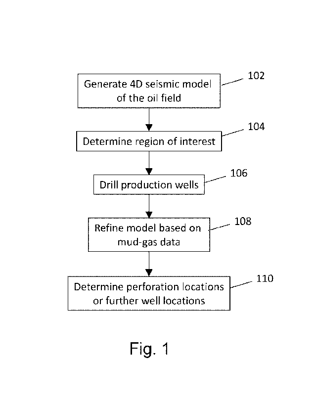
Figure 1 shows a method according to an embodiment of the present
disclosure;
Figure 2 shows a slice through a 4D seismic model of an oil field with a
region of interest highlighted; and
Figure 3 shows a system for generating a gas-oil ratio log from measured
mud-gas data.
A method in accordance with an embodiment of the disclosure is shown in
Figure 1, and will be described in greater detail with reference to Figures 2
and 3.
The method seeks to determine the location of remaining oil reserves within an
oil
field, and particularly a mature oil field having segmented oil reserves.
First, at step 102, a 3D model of the oil field is generated based on all data
available. The 3D model is determined using an initial reservoir fluid
distribution
model, which is then updated based on 4D seismic data collected over the
lifetime
of the oil field.
This 4D seismic data may be generated by acquisition and later analysis of
sequentially acquired seismic surveys of the oil field. The seismic surveys
may for
example be acquired every 6 months. However, it will be appreciated that more
or
less frequent surveys may be carried out, as desired by the field operator.
After the
field has been in production for two or more years, sufficient seismic survey
data
will usually have been collected to allow for useful 4D seismic analysis to be
carried
out and to track the changes in the reservoir fluid during production. The
time lapse
acquisition of seismic data and the 4D seismic analysis can continue for as
long as
necessary in order to analyse the oil field over its lifetime.
Time-lapse seismic modelling of mature oil fields is commonplace, and it is
expected that a 4D seismic model of the oil field will be readily available.
The 4D
seismic model is a three-dimensional model that preferably provides an
estimated
fluid type (gas, oil, and water) for each location within of three-dimensional
space of
at least part the oil field.
CA 03184573 2022- 12- 29
WO 2022/005298
PCT/N02021/050157
- 8 -
Figure 2 illustrates an exemplary, horizontal slice 200 from a 4D seismic
analysis of the oil field. This analysis shows changes in the composition
within the
oil-field over its lifetime. These changes can be caused by pressure changes,
density changes or saturation changes, and certain assumptions are made in
order
to interpret what these changes mean.
In this example, dark regions indicate areas where the seismic amplitude
has increased, suggesting that water has displaced oil, whilst light regions
indicate
areas where the seismic amplitude has decreased, suggesting that free gas has
displaced oil. These areas of free gas are sometimes described as "gas
brightening".
As can be seen, there are some areas of significant gas brightening within
the oil field due to long time gas injection. Other areas, such as area 202,
contain a
smaller degree of gas brightening, but may potentially also contain viable oil
reserves.
Conventional practice is to avoid any areas showing gas brightening when
drilling new production wells. This is because they typically indicate the
presence of
free gas within the reservoir. Such free gas could be either solution gas, or
injection
gas. These areas are avoided because this unwanted free gas is typically
compressed and re-injected into the reservoir, which adds additional
operational
costs and significant CO2 emissions when producing from the well.
However, the 4D seismic model typically has a practical resolution of about
20-30 meters. In a heavily segmented oil field, reservoirs can form as thin
layers
having a thickness smaller than this resolution. Thus, a thin, oil-filled
reservoir may
be indistinguishable from an adjacent gas-filled space.
Furthermore, the seismic data relies on many assumptions, and so
brightening may not necessarily indicate free gas where one or more of these
assumptions is incorrect.
It is desirable to improve the accuracy and resolution of the model in order
to identify viable oil reserves. For some reservoir zones, it is very
challenging when
4D seismic interpretation indicates oil filling while the petrophysical logs
give the
opposite interpretation. It is highly desirable to have a source of data
providing a
ground truth answer for a decision on drilling and production.
At step 104, a region of interest 202 is identified based on the reservoir
model and the 4D seismic data 200 where the reservoir fluid distribution at
the
location are uncertain. That is to say, where it is uncertain whether the
region
CA 03184573 2022- 12- 29
WO 2022/005298
PCT/N02021/050157
- 9 -
comprises reservoirs containing mainly free gas or one or more reservoir
layers
containing oil.
Next, at step 106, a plurality of production wells are drilled into the region
of
interest. In a mature oil field, the production wells will often be highly
deviated or
horizontal wells. Thus, sections of the production well may be oriented at an
angle
of at least 60 degrees to vertical. Whilst these production wells are being
drilled,
mud-gas data is collected.
Mud-gas logging entails gathering data from hydrocarbon gas detectors that
record the levels of gases brought up to the surface in the drilling mud
during a bore
drilling operation. The composition of the gas may be examined for example
with a
gas chromatograph. The detection of the composition of the mud gas described
below is sometimes referred to as "advanced mud-gas logging".
The composition of the mud gas can be examined in order to provide
predictions of the C1 to C5 concentrations within the reservoir fluid.
The measured mud-gas data is usually referred to as "raw" mud-gas data
and is not comparable to the actual composition of the reservoir, since the
mud gas
contains gases that do not originate from the reservoir (e.g. gases present in
the
drilling mud or remaining from previous injection when recycling the drilling
mud)
and also because lighter hydrocarbon (e.g. Ci) are carried more easily by the
drilling mud than heavier hydrocarbons (e.g. 02 to 05).
Firstly, a recycling correction is made to eliminate contamination of the gas
by gases originating from previous injections of the drilling mud. This
correction is
applied based on a separate mud-gas measurement that was taken before the
drilling mud was injected into the drilling string.
Secondly, an extraction efficiency correction step is applied to increase the
concentration of intermediate components (from 02 to 05), such that the mud-
gas
data after this step closely resembles a corresponding reservoir fluid sample
composition.
The mud-gas data after recycling correction and extraction efficiency
correction is usually referred to as "fully corrected" or "advanced" mud-gas
data.
Referring to Figure 3, mud-gas data 302 can be collected substantially
continuously during drilling so as to generate a substantially continuous log,
and
importantly does not require interruption of the drilling process. The log
typically
comprises a concentration of each of the C1 to C5 components of the mud-gas at
each depth.
CA 03184573 2022- 12- 29
WO 2022/005298
PCT/N02021/050157
- 10 -
By using an advanced machine learning model 304 it is possible to predict
various properties from the measured mud-gas data. In particular, the present
inventor has developed a technique whereby fluid properties of reservoir fluid
can
be estimated with a high degree of accuracy, even where those properties are
dependent upon the oil part (C7+) of the fluid which is not measured by the
mud-gas
data.
Details of how the machine learning model may be trained to determine a
gas-oil ratio of the reservoir fluid based on the measured mud-gas data can be
found in the paper Tao Yang et. al. (2019), "A Machine Learning Approach to
Predict Gas Oil Ratio Based on Advanced Mud Gas Data". Society of Petroleum
Engineers. doi:10.2118/195459-MS.
By applying the machine learning model 304 to the mud-gas data 302, it is
possible to generate a substantially continuous gas-oil ratio log 306. This
would
often have a resolution of about 1 meter, which is significantly higher than
the 20-
30m resolution of the 4D seismic data.
Gas-oil ratio logs 306 will be generated from mud-gas data 302 collected
during the drilling of each of a plurality of production wells within the
region of
interest 202. Based on these gas-oil ratio logs 306 it is possible to refine
the
assumptions made when interpreting the 4D seismic data 200 and to better
understand what is being shown with greater precision, thereby allowing
generation
of a refined model covering at least the region of interest 202 that provides
greater
accuracy and a greater resolution, and in particular is sufficiently granular
to identify
oil reservoirs within the region of interest 202.
This new, refined model can be used for many purposes. However, the two
primary purposes it may be used for are, as shown at step 110, to determine
the
locations for new wells, and to determine where to perforate the plurality of
production wells discussed above.
Whilst the production wells may drill through the region of interest 200,
hydrocarbons will only be produced where the casing of the well is perforated.
The
refined model can be used to determine with a high degree of confidence
whether
remaining oil is present within the region of interest 200, and precisely
where it is
located.
If viable oil reserves are identified by the refined model with a high degree
of
confidence, then the casing will be perforated at those locations to produce
the oil.
If no oil reserves are identified, or if a degree of confidence remains too
low, then
CA 03184573 2022- 12- 29
WO 2022/005298
PCT/N02021/050157
- 11 -
no perforations will be made to avoid the risk of a gas breakthrough. This
represents a significant cost saving, as the completion of the well typically
accounts
for a greater proportion of the costs than the drilling of the well.
Advantageously, the refined model provides a much greater degree of
confidence as to the reservoir fluid property in a new reservoir within a
mature oil
field. Thus, it may be possible to omit certain protective measures, e.g.
inflow
control devices, which would otherwise need to be included in view of the risk
of
breaching a reservoir containing free gas.
A second use of the refined model may be to determine locations for future
production wells. Where a plurality of wells are drilled, it is possible to
interpolate
between the logs for each of the existing production wells to determine
further
regions where oil reserves are likely. It has been found that this may be
possible
after about several production wells have been drilled depending on the
complexity
of the reservoirs, although the accuracy of the model improves as more wells
are
drilled.
It will be appreciated that mud-gas data may be logged when drilling these
further production wells to generate a further refined model of the area of
interest,
as well as to determine where to perforate those further production wells.
Whilst preferred embodiments have been described above, it will be
appreciated that these have been provided by way of example only, and the
scope
of the invention is to be limited only by the following claims.
CA 03184573 2022- 12- 29