Note : Les descriptions sont présentées dans la langue officielle dans laquelle elles ont été soumises.
VEHICLE CONTROL SYSTEM
BACKGROUND
Technical Field.
[0001] The subject matter described herein relates to systems that control
operation of
vehicles.
Discussion of Art.
[0002] Many vehicles rely on tracking or knowing locations of the vehicles in
controlling
movement of the vehicles. For example, many vehicles and different types of
vehicles (e.g.,
automobiles, rail vehicles, buses, trucks, mining vehicles, manned or unmanned
aircraft,
agricultural vehicles, marine vessels, etc.) may use navigation systems to
control when,
where, and how the vehicles move along routes between locations.
[0003] As one example of such a navigation system, some rail vehicles may use
vehicle
control systems to control where, when, and/or how the rail vehicles may move
to avoid
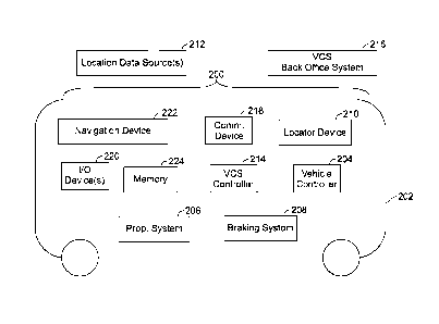
collisions between the vehicles, to avoid moving in unsafe manners (e.g., too
fast through
curves or through areas where maintenance crews are present, etc.), and the
like. One
example of such a navigation system is a Positive Train Control (PTC) system.
The PTC
system includes both off-board and onboard components. Vehicles report
positions,
speeds, etc. to the off-board component of the PTC system. The off-board
component
monitors the movements of many vehicles based on these reports, and sends
instructions
(e.g., movement authorities) that inform the onboard components of which
segments of
routes that the vehicles can safely enter into, how fast the vehicles can move
in different
segments of the routes, etc., to prevent collisions and/or ensure the vehicles
are otherwise
moving in safe ways.
[0004] For these control systems to be able to operate, the control systems
may require that
an initial or starting location of a vehicle be known. For example, the PTC
system may
need to know which track a rail vehicle is starting a trip. Currently, the
control systems
may require that a global navigation satellite system (GNSS) signal be
received to
1
Date Recue/Date Received 2023-06-26
determine the possible starting location of the vehicle. The GNSS signal can
be a signal
that includes or represents a geographic position (latitude, longitude, and/or
altitude) of the
vehicle, and can be obtained by a GNSS receiver (e.g., a Global Positioning
System, or
GPS, receiver) onboard the vehicle that receives signals from off-board GNSS
components
(e.g., GNSS satellites).
[0005] One issue with requiring and relying on GNSS signals to determine a
vehicle
location is that there may be locations where GNSS signals are not available.
For example,
a vehicle may not be able to determine or report a GNSS-based location while
the vehicle
is located in or below structures such as underground stations, platforms with
metal
awnings, stations under buildings, parking lots, underpasses, trenches,
tunnels, etc. Some
control systems may be able to rely on the last known location of the
vehicles, such as the
last reported location of a vehicle when the vehicle ended the prior trip.
There are, however,
are limitations on when the last known location can be stored and used for a
new trip,
including the lack of a quality wheel tachometer and movement of the vehicle
since the
prior trip. Additionally, there may be times when the vehicle is a multi-
vehicle system
formed from several vehicles, and control of the multi-vehicle system may
switch from
one vehicle (e.g., a locomotive at one end of a train) to another vehicle
(e.g., a locomotive
at the opposite end of the train). As these controlling vehicles are
necessarily in different
locations, the last known location of the prior controlling vehicle may not be
useful for
initiating control by the control system when the next trip begins.
[0006] While some known control systems may rely on the addition of sensors,
new signals
and/or sources of those signals to determine locations of vehicles in GNSS
dark areas (areas
where GNSS signals cannot be received from the off-board sources), these other
known
control systems may increase the cost and complexity of operating the
vehicles. It may be
desirable to have a vehicle control system and method that differs from those
that are
currently available.
2
Date Recue/Date Received 2023-06-26
BRIEF DESCRIPTION
[0007] In one example, a method (e.g., for initializing a vehicle for movement
under or
with the protection of a vehicle control system) is provided. The method may
include
determining a sensed location of a vehicle based off one or more location
signals received
from an off-board source, and calculating a calculated location of the vehicle
responsive to
the vehicle moving into a blocking structure where the vehicle does not
determine the
sensed location of the vehicle based off the one or more location signals. The
calculated
location of the vehicle may be calculated using one or more sensor outputs.
The method
also may include selecting a route from among several routes within the
blocking structure
based on the calculated location, communicating the route that is selected to
a back-office
system, and controlling movement of the vehicle using one or more control
signals received
from the back-office system that are based on the route that is selected.
[0008] In one example, a system (e.g., a vehicle control system) is provided.
The system
may include one or more controllers that may determine a sensed location of a
vehicle
based off one or more location signals received from an off-board source. The
one or more
controllers may calculate a calculated location of the vehicle responsive to
the vehicle
moving into a blocking structure where the vehicle does not determine the
sensed location
of the vehicle based off the one or more location signals. The calculated
location of the
vehicle may be calculated using one or more sensor outputs. The one or more
controllers
may select a route from among several routes within the blocking structure
based on the
calculated location and to communicate the route that is selected to a back
office system,
and may control movement of the vehicle using one or more control signals
received from
the back office system that are based on the route that is selected.
[0009] In one example, a method may include determining sensed locations of a
vehicle
while the vehicle receives GNSS signals, sensing movement of the vehicle using
one or
more inertial measurement sensors, calculating one or more calculated
locations of the
vehicle based on at least one of the sensed locations and the movement of the
vehicle that
is sensed using the one or more inertial measurement sensors and responsive to
no longer
receiving the GNSS signals, selecting a route from several different routes as
a beginning
3
Date Recue/Date Received 2023-06-26
route for a trip of the vehicle (where the beginning route is selected based
on the one or
more calculated locations), initializing the vehicle for the trip by
communicating the
beginning route of the vehicle to an off-board system of a positive control
system, and
controlling movement of the vehicle based on one or more control signals
received from
the off-board system responsive to initializing the vehicle for the trip.
BRIEF DESCRIPTION OF THE DRAWINGS
[0010] The subject matter may be understood from reading the following
description of
non-limiting embodiments, with reference to the attached drawings, wherein
below:
[0011] Figure 1 illustrates one example of a network of routes extending into
and/or
through a blocking structure;
[0012] Figure 2 illustrates one example of a vehicle control system;
[0013] Figure 3 illustrates one example of route selection for reporting to an
off-board
component of a positive (or negative) control system during or for trip
initialization;
[0014] Figure 4 illustrates another example of route selection for reporting
to the off-board
component of the positive (or negative) control system during or for trip
initialization;
[0015] Figure 5 illustrates another example of route selection for reporting
to the off-board
component of the positive (or negative) control system during or for trip
initialization; and
[0016] Figure 6 illustrates a flowchart of one example of a method for
determining
locations of vehicles.
DETAILED DESCRIPTION
[0017] Embodiments of the subject matter described herein relate to vehicle
control
systems and methods that determine locations of vehicles. This may occur in
areas where
the vehicles may be unable to accurately (e.g., correctly) and/or precisely
(e.g., with an
acceptable range of error) determine the locations of the vehicles. These
determined
locations may then be used by the vehicle control systems to assist the
vehicles in safe
movement, such as by instructing onboard components of the vehicle control
systems
when, where, and/or how the vehicles can safely travel through or on different
segments of
4
Date Recue/Date Received 2023-06-26
routes. In one embodiment, the vehicle control system and method may rely on
existing
components already onboard a vehicle to determine locations (e.g., initial
locations before
a trip is begun) without having to add more components, rely on additional
signals from an
off-board source, etc.
[0018] As one example, existing navigation devices may operate in conjunction
with
GNSS receivers to determine locations of vehicles in the absence of GNSS
signals. For
example, an inertial measurement unit (IMU, such as the WABTEC GoLINC precise
navigation module, or PNM) can determine a geographic position of a vehicle in
the
absence of receiving GNSS signals from off-board sources (e.g., GNSS
satellites). This
geographic position or location can be determined based on the inertial data
output by the
IMU and a previously determined (e.g., the last known) GNSS geographic
position or
location. For example, the navigation device can measure the heading and speed
of the
vehicle. Based on this heading and speed at which the vehicle moves from the
last known
GNSS-derived location, the current or new location of the vehicle (e.g., in or
within an area
where GNSS signals cannot be received) can be determined. This location can be
reported
to the vehicle control system and used to begin monitoring the movement of the
vehicle
(for creating movement authorities or other restrictions that ensure that safe
movement of
that vehicle and other vehicles).
[0019] In situations where the vehicle control system is starting or
initializing for a new
trip, the vehicle control system may use the geographic location of the
vehicle that is
determined from the navigation device in the absence of GNSS signal reception
to
determine the possible route locations where the vehicle might be located.
Optionally, the
navigation device can calculate a position error (e.g., a standard deviation
or other error
calculation) that indicates several possible locations (e.g., an area) where
the vehicle may
be located based on the last known GNSS location and the information measured
by the
navigation device (e.g., heading and moving speed since the last known GNSS
location
was determined). This error may extend over or encompass one or more routes.
For
example, the error may be represented by a circle, sphere, or other shape that
overlaps with
one or more routes (e.g., on a two-dimensional or three-dimensional map).
Depending on
Date Recue/Date Received 2023-06-26
the number of routes that the error overlaps, the off-board and/or onboard
components of
the vehicle control system may automatically identify the route on which the
vehicle is
located, may select a set of routes for presentation to one or more onboard
operators for
selection of which route the vehicle is located on, or may determine that the
component(s)
are unable to automatically identify or select a set of routes for
presentation to the
operator(s). For example, if the error bounds (e.g., the circle, sphere, or
other shape)
overlaps a single route, the system may automatically select the route on
which the vehicle
is located (as that single route). If the error bounds overlap multiple routes
(e.g., two or
more neighboring parallel tracks, lanes of a road, parallel roads, etc.), then
the system may
present a list or map of these routes that overlap with the error bounds for
presentation and
selection by the operator(s). In one example, if the error bounds overlap many
routes (e.g.,
more than a threshold number, such as three in one embodiment), then the
system may
determine that the system is unable to identify the route on which the vehicle
is located.
Alternatively, if the error bounds overlap many routes (e.g., more than the
threshold
number), then the system may still present these routes that overlap the error
bounds for
presentation and selection by the operator(s). With the route on which the
vehicle is located
being selected, the off-board components of the vehicle control system may
begin tracking
movements of the vehicle. This allows the vehicle control system to warn or
restrict
movements of other vehicles based on movements of the vehicle having the
selected route,
as described herein.
[0020] Figure 1 illustrates one example of a network 100 of routes 102
extending into
and/or through a blocking structure 104. The routes can represent roads,
tracks, lanes of
the same or neighboring roads, paths, waterways, or other vehicle routes on
which vehicle
systems 106, 108, 110 may travel. The vehicle systems can represent a single
vehicle 112
(e.g., the vehicle system 110) or multi-vehicle systems (e.g., the vehicle
system 106 and/or
108) formed from multiple vehicles. The vehicles in the multi-vehicle system
can be
mechanically coupled with each other or may remain separate but coordinate
movements
so that the vehicles in the vehicle system move together (e.g., in a platoon,
convoy, swarm,
etc.). The vehicles can be propulsion-generating vehicles (e.g., automobiles,
trucks,
6
Date Recue/Date Received 2023-06-26
locomotives, etc.). In the multi-vehicle systems, one or more (but fewer than
all) of the
vehicles can represent non-propulsion-generating vehicles (e.g., trailers,
railcars, etc.). The
structure can represent any man-made or natural object that can interfere
with, or block
reception of location signals sent by off-board sources (e.g., GNSS
satellites). For example,
the structure can represent a building, parking lot, canopy, tunnel, ravine,
valley, mountain,
trees, etc. that partially or entirely block transmission of GNSS satellites
to GNSS receivers
onboard the vehicle systems. As another example, the blocking structure can
represent a
non-physical blocking or impedance to transmission of the GNSS signals. For
example,
GNSS signals may be blocked through GNSS jamming where other signals are
intentionally or unintentionally transmitted and jam or otherwise interfere
with
transmission of the GNSS signals. The vehicles may be unable to receive the
GNSS signals
while the vehicle systems are beneath or within the structure (e.g., or within
an area where
other signals are jamming or interfering with the GNSS signals).
[0021] With continued reference to the vehicle systems and structure shown in
Figure 1,
Figure 2 illustrates one example of a vehicle control system 200. The vehicle
control
system may be off-board and/or onboard a vehicle 202, such as a propulsion-
generating
vehicle. The vehicle shown in Figure 2 can represent one or more of the
vehicles in the
vehicle systems shown in Figure 1. One or more components of the vehicle
control system
may be off board the vehicle while one or more other components of the vehicle
control
system may be onboard the vehicle. Alternatively, all components of the
vehicle control
system may be onboard the vehicle.
[0022] A vehicle controller 204 controls the operation (e.g., movement) of the
vehicle. The
vehicle controller can represent hardware circuitry that includes and/or is
connected with
one or more processors (e.g., microprocessors, integrated circuits, field
programmable gate
arrays, etc.) that perform the operations described in connection with the
vehicle controller.
For example, the vehicle controller can communicate with a propulsion system
206 ("Prop.
System" in Figure 2, such as one or more engines, motors, or the like) to
control propulsion
of the vehicle and vehicle system, and/or a braking system 208 (e.g., one or
more friction
brakes, air brakes, or the like) to slow or stop movement of the vehicle and
vehicle system.
7
Date Recue/Date Received 2023-06-26
[0023] A locator device 210 may determine the geographic locations of the
vehicle. In one
embodiment, the locator device communicates with one or more location data
sources 212
that are off board the vehicle to determine the locations of the vehicle. For
example, the
location data sources can represent GNSS satellites or beacons that broadcast
signals that
are received by the locator device (e.g., a GNSS or GPS receiver). The locator
device can
determine the location, heading, speed, etc. of the vehicle based on these
signals.
Alternatively, the locator device can include a sensor that detects one or
more
characteristics to determine the locations of the vehicle. For example, the
locator device
can represent a radio frequency identification (RFID) reader that reads an
RFID tag
associated with a known location to determine the vehicle location. As another
example,
the locator device can represent an optical sensor, such as a camera, that
optically reads
where the vehicle is located (e.g., from one or more signs, such as waypoints,
road signs,
etc.). In one example, the locator device (and/or the vehicle controller) can
apply one or
more filters to the signals received from the location data source(s), such as
a Kalman filter.
[0024] A vehicle control system controller 214 ("VCS Controller" in Figure 2)
represents
an onboard component of the vehicle control system. The VCS controller can
communicate
with an off-board component of the vehicle control system, such as a vehicle
control system
back-office system 216 ("VCS Back Office System" in Figure 2). The VCS
controller and
the back-office system can communicate with each other via a communication
device 218
("Comm. Device" in Figure 2), which can represent hardware transceiving
circuitry, such
as a transceiver, modem, antenna, and the like. The back-office system also
can include a
communication device 218 to allow for communication with the vehicles. The VCS
controller can represent hardware circuity that includes and/or is connected
with one or
more processors. The VCS controller can communicate with the back-office
system to
report locations of the vehicle, moving speeds of the vehicle, headings or
directions of
movement of the vehicle, etc. The VCS controller also can receive directive
signals from
the back-office system. These signals can include movement restrictions, such
as
movement authorities that dictate where, when, and/or how the vehicle can
move. The
back-office system can determine whether to allow different vehicles to enter
into different
8
Date Recue/Date Received 2023-06-26
route segments and/or how the vehicles can move in those segments based on
reported
locations, speeds, and/or headings of the vehicles, as well as reported areas
of the routes
undergoing repair, maintenance, etc.
[0025] For example, the back-office system and the VCS controller can be
components of
a positive control system that sends movement authorities to vehicles to
inform the vehicles
whether the vehicles can travel into an upcoming segment of a route, how fast
the vehicles
can move in the upcoming segment of the route, etc. If the VCS controller
receives a
permissive movement authority from the back office system indicating that the
vehicle can
enter into the upcoming segment, then the VCS controller can inform the
operator (e.g.,
via an input and/or output device 220, or "I/O Device" in Figure 2) of whether
the vehicle
can move into the upcoming segment (and optionally how fast the vehicle can
move in the
upcoming segment). Optionally, the VCS controller can allow the vehicle to
move into the
upcoming segment responsive to receiving the movement authority. But if the
VCS
controller does not receive the movement authority, then the VCS controller
may inform
the operator of the vehicle and/or generate signals to automatically control
the propulsion
system and/or braking system to prevent the vehicle from entering into the
upcoming
segment of the route and/or to prevent the vehicle from moving in the upcoming
segment
of the route in a way that violates the movement authority (e.g., moving
faster than the
movement authority dictates).
[0026] As another example, the back-office system and the VCS controller can
be
components of a negative control system that sends movement authorities to
vehicles to
inform the vehicles where the vehicles cannot travel. If the VCS controller
receives a
movement authority from the back-office system indicating that the vehicle
cannot enter
into the upcoming segment, then the VCS controller can inform the operator
and/or
automatically control the propulsion system and/or braking system to prevent
disallowed
movement of the vehicle in the upcoming segment. If the VCS controller does
not receive
the movement authority from the back-office system indicating that the vehicle
cannot
enter into the upcoming segment, then the VCS controller can inform the
operator and/or
allow movement of the vehicle in the upcoming segment.
9
Date Recue/Date Received 2023-06-26
[0027] A navigation device 222 can determine locations of the vehicle based
off
information other than or in addition to the off-board signals received from
the location
data source(s). For example, the navigation device can include or represent
one or more
sensors that detect movement of the vehicle. These sensors can include one or
more IMUs,
accelerometers, magnetometers, tachometers (e.g., wheel and/or other
tachometers), etc.
The navigation device optionally can include one or more processors that
examine the
information sensed by the sensors to determine the movement and/or change in
location of
the vehicle. Alternatively, the navigation device may include the sensor(s)
but may send
the output from the sensor(s) to the VCS controller and/or the vehicle
controller to calculate
the location of the vehicle based on the sensor output. The navigation device
and/or the
vehicle controller can apply one or more filters, such as a Kalman filter, to
the output of
the sensor(s). In one embodiment, the navigation device (or the controller(s))
can employ
a dead reckoning calculation, a wireless triangulation calculation, or the
like, to monitor or
determine the location(s) of the vehicle in locations and/or during times when
the locator
device is unable to do so and/or the locator device is unable to receive the
signals from the
location data source(s).
[0028] The I/0 device referred to above can represent a display screen, a
touchscreen, a
speaker, or the like, which is used to communicate information with an
operator onboard
the vehicle. A tangible and computer-readable storage medium (e.g., a computer
hard drive,
disc, removable memory, etc.), or memory 224, optionally can be onboard the
vehicle. This
memory can store information determined by the navigation device,
controller(s), and/or
locator device, such as a last-known location determined from the off-board
signals
received from the location data source(s), the location determined by the
navigation device
or controller(s) based on the output from the navigation device (e.g., the
dead-reckoning
determined location), or the like. The memory optionally can store route
layouts, such as a
map or other information on the locations, curves, paths, etc. of various
routes on which
the vehicle may or will travel.
[0029] In operation, the control system can initiate a trip of the vehicle (or
a multi-vehicle
system that includes the vehicle) by obtaining one or more off-board signals
from the
Date Recue/Date Received 2023-06-26
location data source(s) and determine the geographic location of the vehicle.
The VCS
controller can examine this location and the route layouts (e.g., as obtained
from the
memory and/or received from a communication from the back-office system) to
determine
which route the vehicle is located. For example, the VCS controller can
determine whether
the geographic location of the vehicle as determined by the locator device is
on or near a
route (e.g., within a threshold distance, such as three meters or a distance
between
neighboring routes). The VCS controller can identify this route as the route
currently
occupied by the vehicle and on which the vehicle will begin the trip. The VCS
controller
can communicate this identified route to the back-office system so the back-
office system
can determine where the vehicle is located to determine which route segments
that the
vehicle can enter into, how fast the vehicle can move through the route
segments, and the
like.
[0030] During movement of the vehicle, the vehicle may enter the blocking
structure
described above. This can impede or prevent the locator device from being able
to receive
signals from the location data source(s) and, therefore, determine the
location of the
vehicle. If the vehicle is pausing or ending a trip in the blocking structure,
then the locator
device may be unable to determine the location of the vehicle when the next
trip begins.
This can prevent the VCS controller from reporting the location of the vehicle
to the back-
office system, which can result in the back-office system being unable to
determine where
the vehicle is located, and which route the vehicle is beginning a trip on.
Consequently, the
back-office system may not be able to inform the VCS controller of which route
segments
to travel on and/or how fast to move. In short, the back-office system may not
be able to
provide the protection that the back-office system would be able to if the
starting location
of the vehicle was known.
[0031] To prevent this from occurring, the navigation device, VCS controller,
and/or
vehicle controller can determine a last-known location of the vehicle from the
locator
device before the locator device is unable to determine the location of the
vehicle. For
example, prior to entering the blocking structure, the locator device may
provide a
geographic location of the vehicle outside of the blocking structure. This
last-known
11
Date Recue/Date Received 2023-06-26
location may be a location that is just outside the blocking structure (e.g.,
within ten meters
of an exterior of the blocking structure) or farther from the blocking
structure.
[0032] The navigation device, VCS controller, and/or vehicle controller can
use this last-
known location, as well as the speed and/or heading of the vehicle (as
determined by the
navigation device), to calculate one or more additional locations of the
vehicle within the
blocking structure. The navigation device, VCS controller, and/or vehicle
controller can
use dead-reckoning calculations to approximate the location of the vehicle
within the
blocking structure. The location of the vehicle determined from the locator
device can be
referred to as the sensed location due to the location being determined based
off signals
sensed (e.g., received) from off-board or external locations, such as the
location data
source(s). The location(s) of the vehicle that is or are determined from the
output from the
navigation device (e.g., the location(s) determined using dead reckoning) may
be referred
to as calculated locations as these locations are calculated by the vehicle
(based off of
output from a device onboard the vehicle, such as the navigation device). The
VCS
controller, navigation device, and/or vehicle controller can calculate the
calculated
locations until the vehicle stops within the blocking structure or can
calculate the calculated
location once the vehicle has stopped within the blocking structure.
[0033] This calculated location (or the last calculated location) can then be
used to initialize
the VCS controller for controlling movement of the vehicle during a subsequent
trip. For
example, prior to the vehicle or vehicle system beginning another trip
starting inside the
blocking structure, the vehicle or vehicle system may need to communicate the
starting
location and/or identification of the route on which the vehicle or vehicle
system is located.
This information is received by the back-office system, and the back-office
system can
send a confirmatory signal to the VCS controller to notify that controller
that the location
and movement of the vehicle or vehicle system is being tracked by the back-
office system.
This confirms that the back-office system can continue to issue signals to the
vehicle to
ensure the safe movement of the vehicle (or vehicle system that includes the
vehicle).
[0034] In one embodiment, the memory may store route locations and layouts,
including
those routes inside a blocking structure. The VCS controller, vehicle
controller, and/or
12
Date Recue/Date Received 2023-06-26
navigation device can automatically select the route on which the vehicle (or
vehicle
system) is located based on the calculated location of the vehicle (e.g., that
is determined
after the vehicle has stopped). For example, the VCS controller can select the
route from
among several routes based on which route the calculated location is disposed.
Optionally,
one or more routes may be recommended for selection by an operator (and for
reporting to
the back-office system during trip initialization) based on the calculated
location that is
determined. For example, the VCS controller can identify one or more routes
that are near
(e.g., within a threshold distance, such as an error bound or standard
deviation) of the
calculated location. These routes may be potential routes for selection, and
can be presented
to an operator (e.g., via the I/0 device) for selection.
[0035] Figures 3 through 5 illustrate different examples of route selection
for reporting to
the back-office system during or for trip initialization. In each of these
examples, there are
several nearby routes that may be within the blocking structure. A circle 326,
426, 526 in
each of Figures 3 through 5 indicates the error range of the location of the
vehicle that is
calculated using the last known sensed location, along with the output from
the navigation
device. For example, these circles can represent the standard deviation or
designated
number of standard deviations (e.g., two or three standard deviations) of the
calculated
location based on the dead reckoning calculation used to calculate the
stopping location of
the vehicle. The circle in Figure 3 is smaller than the circle in each of
Figure 4 and Figure
5, while the circle in Figure 5 is the largest of the circles in Figures 3
through 5. This can
indicate that the estimated amount of error of the calculated location is
greatest in the
example of Figure 3 and the lowest in the example of Figure 5.
[0036] There can be different error ranges for different calculated locations
due to a variety
of factors. One example of a factor is the speed at which the vehicle was
moving after the
last known sensed location was determined (with the size of the error
increasing for faster
speeds and decreasing for slower speeds). Another example of a factor is the
number or
magnitude of accelerations or decelerations of the vehicle after the last
known location was
determined (with the size of the error increasing for greater and/or more
frequent
accelerations or decelerations and decreasing for smaller and/or fewer
accelerations or
13
Date Recue/Date Received 2023-06-26
decelerations). Another example of a factor is the number or magnitude of
turns of the
vehicle after the last known location was determined (with the size of the
error increasing
for more turns and/or sharper turns and decreasing for fewer and/or less sharp
turns).
[0037] In the example of Figure 3, the VCS controller, the vehicle controller,
and/or the
navigation device can determine that the vehicle (or vehicle system) is
located on a selected
route 102A of the routes. This route is selected as the error bounds (e.g.,
the circle in Figure
3) extends over only a single route. This route may be automatically selected
by the
controller(s) and/or navigation device, and reported to the back-office
system, without
operator intervention in one example. Optionally, this route may be
automatically selected
by the controller(s) and/or navigation device, presented to the operator, and
reported to the
back-office system once the operator confirms the selected route (e.g., via
the I/O device).
[0038] In the example of Figure 4, the VCS controller, the vehicle controller,
and/or the
navigation device can determine that the vehicle (or vehicle system) is
located on one of
several potential routes 102B, 102C. These routes may be selected as potential
routes due
to the error bounds (e.g., the circle in Figure 4) extending over these two
routes. These
routes may be presented to the operator, and the operator can select the route
102B or 102C
from these presented routes for reporting to the back-office system. This can
reduce the
potential for human error by requesting that the operator select the route
from a thinned
down or reduced list of potential routes based on the calculated location and
the error
bounds extending around the calculated location.
[0039] In the example of Figure 5, the VCS controller, the vehicle controller,
and/or the
navigation device can determine that the vehicle (or vehicle system) is
located on one of
several potential routes 102D, 102E, 102F, 102G. These routes may be selected
as potential
routes due to the error bounds (e.g., the circle in Figure 5) extending over
these two routes.
These routes may be presented to the operator, and the operator can select the
route 102D,
102E, 102F, or 102G from these presented routes for reporting to the back-
office system.
This can reduce the potential for human error by requesting that the operator
select the
route from a thinned down or reduced list of potential routes based on the
calculated
location and the error bounds extending around the calculated location.
14
Date Recue/Date Received 2023-06-26
[0040] The vehicle controller and the VCS controller can then begin a new trip
with the
vehicle or vehicle system identified as starting on the automatically selected
route, or the
route selected by an operator from an automatically selected list of routes.
While one
embodiment described herein relates to using the calculated location (and
error bounds) for
establishing protection by the back-office system (such as a PTC system), not
all
embodiments are limited to back-office system operation, PTC systems, rail
vehicles, or
the like. For example, the inventive subject matter described herein may be
used in
connection with other vehicles (e.g., automobiles), trucks, mining vehicles,
marine vessels,
or the like, to calculate potential locations of the vehicles using both
sensed and calculated
locations (e.g., in areas where the signals from the location data sources are
not available).
[0041] In one embodiment, the control system may have a local data collection
system
deployed that may use machine learning to enable derivation-based learning
outcomes. The
controller(s) may learn from and make decisions on a set of data (including
data provided
by the various sensors), by making data-driven predictions and adapting
according to the
set of data. In embodiments, machine learning may involve performing a
plurality of
machine learning tasks by machine learning systems, such as supervised
learning,
unsupervised learning, and reinforcement learning. Supervised learning may
include
presenting a set of example inputs and desired outputs to the machine learning
systems.
Unsupervised learning may include the learning algorithm structuring its input
by methods
such as pattern detection and/or feature learning. Reinforcement learning may
include the
machine learning systems performing in a dynamic environment and then
providing
feedback about correct and incorrect decisions. In examples, machine learning
may include
a plurality of other tasks based on an output of the machine learning system.
In examples,
the tasks may be machine learning problems such as classification, regression,
clustering,
density estimation, dimensionality reduction, anomaly detection, and the like.
In examples,
machine learning may include a plurality of mathematical and statistical
techniques. In
examples, the many types of machine learning algorithms may include decision
tree based
learning, association rule learning, deep learning, artificial neural
networks, genetic
learning algorithms, inductive logic programming, support vector machines
(SVMs),
Date Recue/Date Received 2023-06-26
Bayesian network, reinforcement learning, representation learning, rule-based
machine
learning, sparse dictionary learning, similarity and metric learning, learning
classifier
systems (LCS), logistic regression, random forest, K-Means, gradient boost, K-
nearest
neighbors (KNN), a priori algorithms, and the like. In embodiments, certain
machine
learning algorithms may be used (e.g., for solving both constrained and
unconstrained
optimization problems that may be based on natural selection). In an example,
the
algorithm may be used to address problems of mixed integer programming, where
some
components restricted to being integer valued. Algorithms and machine learning
techniques and systems may be used in computational intelligence systems,
computer
vision, Natural Language Processing (NLP), recommender systems, reinforcement
learning, building graphical models, and the like. In an example, machine
learning may be
used for vehicle performance and behavior analytics, and the like.
[0042] In one embodiment, the controller(s) may include a policy engine that
may apply
to one or more policies. These policies may be based at least in part on
characteristics of a
given item of equipment or environment. With respect to control policies, a
neural network
can receive input of a number of environmental and task-related parameters.
These
parameters may include an identification of a determined trip plan for a
vehicle group, data
from various sensors, and location and/or position data. The neural network
can be trained
to generate an output based on these inputs, with the output representing an
action or
sequence of actions that the vehicle group should take to accomplish the trip
plan. During
operation of one embodiment, a determination can occur by processing the
inputs through
the parameters of the neural network to generate a value at the output node
designating that
action as the desired action. This action may translate into a signal that
causes the vehicle
to operate. This may be accomplished via back-propagation, feed forward
processes, closed
loop feedback, or open loop feedback. Alternatively, rather than using
backpropagation,
the machine learning system of the controller may use evolution strategies
techniques to
tune various parameters of the artificial neural network. The controller may
use neural
network architectures with functions that may not always be solvable using
backpropagation, for example functions that are non-convex. In one embodiment,
the
16
Date Recue/Date Received 2023-06-26
neural network has a set of parameters representing weights of its node
connections. A
number of copies of this network are generated and then different adjustments
to the
parameters are made, and simulations are done. Once the outputs from the
various models
are obtained, they may be evaluated on their performance using a determined
success
metric. The best model is selected, and the vehicle controller executes that
plan to achieve
the desired input data to minor the predicted best outcome scenario.
Additionally, the
success metric may be a combination of optimized outcomes, which may be
weighed
relative to each other.
[0043] The controller(s) can use this artificial intelligence or machine
learning to receive
input (e.g., a sensed location, moving speed of the vehicle, heading and/or
change in
heading of the vehicle, etc.), use a model that associates inputs or
combinations of inputs
with different calculated locations, different error bounds, and/or different
routes within a
blocking structure to select a calculated location, error bound, and/or route,
and then
provide an output (e.g., the calculated location, error bound, and/or route
selected using the
model). The controller(s) may receive additional input or feedback, such as an
actual error
or difference between the calculated location and actual location of the
vehicle, the actual
route on which the vehicle is located, etc. Based on this additional input,
the controller(s)
can change the model, such as by changing which calculated location, error
bound, and/or
route would be selected when a similar or identical input is provided the next
time or
iteration. The controller(s) can then use the changed or updated model again
to calculate
the calculated location, calculate an error bound, select a route, etc.,
receive feedback on
the selected location/error/route, change or update the model again, etc., in
additional
iterations to repeatedly improve or change the model using artificial
intelligence or
machine learning.
[0044] Figure 6 illustrates a flowchart of one example of a method 628 for
determining
locations of vehicles. The method can represent operations performed by the
control system
shown in Figure 2 to determine locations of vehicles while the vehicles are in
locations
where external signals (e.g., GNSS signals from the location data sources) may
not be
available or received. At step 630, one or more sensed locations of the
vehicle are
17
Date Recue/Date Received 2023-06-26
determined. These locations can be determined (e.g., calculated) using signals
received
from off-board sources, such as satellite signals. Alternatively, these
locations may be
sensed using one or more sensors such as cameras (e.g., reaching or optically
detecting
location), RFID devices, etc.
[0045] At step 632, a determination is made as to whether the vehicle is
unable to determine
locations of the vehicle from the off-board sources. For example, a decision
may be made
as to whether the vehicle can continue to sense or determine locations based
on signals
received from the off-board sources (e.g., satellites). If the vehicle can no
longer determine
its location from the signals sent by off-board sources (or by sensing objects
outside of the
vehicle), then the vehicle may no longer be able to determine its sensed
location. As a
result, flow of the method can proceed toward step 634. If the vehicle can
still determine
its location from the signals sent by the off-board sources, then the vehicle
can continue to
determine its location from the signals sent by the off-board sources. As a
result, flow of
the method can return toward step 630 or may terminate.
[0046] At step 634, locations of the vehicle are determined based on output
from one or
more sensors (e.g., a navigation device). For example, one or more locations
of the vehicle
may be determined by sensing the speed, heading, vibration, etc. of the
vehicle and using
a dead reckoning calculation. This can allow for the locations of the vehicle
to be
determined even though the signals from the off-board sources may not be able
to be used
for determining the vehicle location. For example, the vehicle can use one or
more inertial
measurement sensors or units for tracking movements of the vehicle and can
calculate
locations of the vehicle using dead reckoning.
[0047] At step 636, the vehicle may determine the final or stopping location
of the vehicle
from a completed trip. For example, the VCS controller, vehicle controller,
and/or
navigation device can determine whether the vehicle has stopped and can
calculate the
stopped location of the vehicle using the information determined at step 634.
[0048] At step 638, a location is reported from the vehicle to an off-board
system, such as
the back-office system, for protective monitoring of the vehicle. For example,
the route on
18
Date Recue/Date Received 2023-06-26
which the vehicle is located may be reported to the back-office system. This
route can be
selected based on the calculated location of the vehicle (e.g., determined at
step 636), as
described above. Optionally, several routes may be presented for selection to
an operator
of the vehicle based on the location determined at step 636, as described
above. The
selected route may represent the location of the vehicle or vehicle system.
[0049] At step 640, movement of the vehicle or vehicle system is controlled
based on
signals received from the back-office system (that are, in turn, based on the
location
reported at step 638). For example, the VCS controller may automatically slow
or stop
movement of the vehicle, may control steering of the vehicle, or the like,
based on signals
received from the back-office system, as described above. Flow of the method
may return
to one or more operations or may terminate.
[0050] While one or more embodiments are described in connection with a rail
vehicle
system, not all embodiments are limited to rail vehicle systems. Unless
expressly
disclaimed or stated otherwise, the subject matter described herein extends to
other types
of vehicle systems, such as automobiles, trucks (with or without trailers),
buses, marine
vessels, aircraft, mining vehicles, agricultural vehicles, or other off-
highway vehicles. The
vehicle systems described herein (rail vehicle systems or other vehicle
systems that do not
travel on rails or tracks) may be formed from a single vehicle or multiple
vehicles. With
respect to multi-vehicle systems, the vehicles may be mechanically coupled
with each other
(e.g., by couplers) or logically coupled but not mechanically coupled. For
example,
vehicles may be logically but not mechanically coupled when the separate
vehicles
communicate with each other to coordinate movements of the vehicles with each
other so
that the vehicles travel together (e.g., as a convoy),In one example, a method
(e.g., for
initializing a vehicle for movement under or with the protection of a vehicle
control system)
is provided. The method may include determining a sensed location of a vehicle
based off
one or more location signals received from an off-board source, and
calculating a
calculated location of the vehicle responsive to the vehicle moving into a
blocking structure
where the vehicle does not determine the sensed location of the vehicle based
off the one
or more location signals. The calculated location of the vehicle may be
calculated using
19
Date Recue/Date Received 2023-06-26
one or more sensor outputs. The method also may include selecting a route from
among
several routes within the blocking structure based on the calculated location,
communicating the route that is selected to a back-office system, and
controlling movement
of the vehicle using one or more control signals received from the back-office
system that
are based on the route that is selected.
[0051] The one or more location signals may be GNSS signals received from one
or more
GNSS satellites as the off-board source. The calculated location may be
calculated using a
dead reckoning calculation. The calculated location may be calculated using
one or more
of vehicle speeds, vehicle vibrations, and/or vehicle headings as the one or
more sensor
outputs. Optionally, the method also may include sensing movement of the
vehicle using
an onboard inertial measurement unit to obtain the one or more sensor outputs.
[0052] The vehicle may be unable to receive the one or more location signals
while the
vehicle is in the blocking structure. The calculated location may be
calculated as the
stopping location of the vehicle from a first trip and as a starting location
for a subsequent
second trip. The route that is selected may be selected by identifying the
several routes that
are within an error range around the calculated location.
[0053] The route that is selected may be automatically selected based on the
calculated
location. The method optionally may include presenting the several routes to
an operator
of the vehicle and receiving a selection of the route that is selected based
on the several
routes being presented.
[0054] In one example, a system (e.g., a vehicle control system) is provided.
The system
may include one or more controllers that may determine a sensed location of a
vehicle
based off one or more location signals received from an off-board source. The
one or more
controllers may calculate a calculated location of the vehicle responsive to
the vehicle
moving into a blocking structure where the vehicle does not determine the
sensed location
of the vehicle based off the one or more location signals. The calculated
location of the
vehicle may be calculated using one or more sensor outputs. The one or more
controllers
may select a route from among several routes within the blocking structure
based on the
Date Recue/Date Received 2023-06-26
calculated location and to communicate the route that is selected to a back
office system
and may control movement of the vehicle using one or more control signals
received from
the back office system that are based on the route that is selected.
[0055] Optionally, the one or more controllers may receive the one or more
location signals
as GNSS signals received from one or more GNSS satellites as the off-board
source. The
one or more controllers may calculate the calculated location using a dead
reckoning
calculation. The one or more controllers may calculate the calculated location
using one or
more of vehicle speeds, vehicle vibrations, and/or vehicle headings as the one
or more
sensor outputs.
[0056] The system optionally may include an onboard inertial measurement unit
that may
output sensed movement of the vehicle as the one or more sensor outputs and/or
a locator
device that may receive the one or more location signals while the vehicle is
outside the
blocking structure but unable to receive the one or more location signals
while the vehicle
is in the blocking structure.
[0057] The one or more controllers may calculate the calculated location as a
stopping
location of the vehicle from a first trip and as a starting location for a
subsequent second
trip. The one or more controllers may select the route by identifying the
several routes that
are within an error range around the calculated location. The one or more
controllers may
automatically select the route that is selected based on the calculated
location. The one or
more controllers may direct presentation of the several routes to an operator
of the vehicle
and may receive a selection of the route that is selected based on the several
routes being
presented.
[0058] In one example, a method may include determining sensed locations of a
vehicle
while the vehicle receives GNSS signals, sensing movement of the vehicle using
one or
more inertial measurement sensors, calculating one or more calculated
locations of the
vehicle based on at least one of the sensed locations and the movement of the
vehicle that
is sensed using the one or more inertial measurement sensors and responsive to
no longer
receiving the GNSS signals, selecting a route from several different routes as
a beginning
21
Date Recue/Date Received 2023-06-26
route for a trip of the vehicle (where the beginning route is selected based
on the one or
more calculated locations), initializing the vehicle for the trip by
communicating the
beginning route of the vehicle to an off-board system of a positive control
system, and
controlling movement of the vehicle based on one or more control signals
received from
the off-board system responsive to initializing the vehicle for the trip.
[0059] In one embodiment, the controllers or systems described herein may have
a local
data collection system deployed and may use machine learning to enable
derivation-based
learning outcomes. The controllers may learn from and make decisions on a set
of data
(including data provided by the various sensors), by making data-driven
predictions and
adapting according to the set of data. In embodiments, machine learning may
involve
performing a plurality of machine learning tasks by machine learning systems,
such as
supervised learning, unsupervised learning, and reinforcement learning.
Supervised
learning may include presenting a set of example inputs and desired outputs to
the machine
learning systems. Unsupervised learning may include the learning algorithm
structuring its
input by methods such as pattern detection and/or feature learning.
Reinforcement learning
may include the machine learning systems performing in a dynamic environment
and then
providing feedback about correct and incorrect decisions. In examples, machine
learning
may include a plurality of other tasks based on an output of the machine
learning system.
In examples, the tasks may be machine learning problems such as
classification, regression,
clustering, density estimation, dimensionality reduction, anomaly detection,
and the like.
In examples, machine learning may include a plurality of mathematical and
statistical
techniques. In examples, the many types of machine learning algorithms may
include
decision tree based learning, association rule learning, deep learning,
artificial neural
networks, genetic learning algorithms, inductive logic programming, support
vector
machines (SVMs), Bayesian network, reinforcement learning, representation
learning,
rule-based machine learning, sparse dictionary learning, similarity and metric
learning,
learning classifier systems (LCS), logistic regression, random forest, K-
Means, gradient
boost, K-nearest neighbors (KNN), a priori algorithms, and the like. In
embodiments,
certain machine learning algorithms may be used (e.g., for solving both
constrained and
22
Date Recue/Date Received 2023-06-26
unconstrained optimization problems that may be based on natural selection).
In an
example, the algorithm may be used to address problems of mixed integer
programming,
where some components restricted to being integer-valued. Algorithms and
machine
learning techniques and systems may be used in computational intelligence
systems,
computer vision, Natural Language Processing (NLP), recommender systems,
reinforcement learning, building graphical models, and the like. In an
example, machine
learning may be used making determinations, calculations, comparisons and
behavior
analytics, and the like.
[0060] In one embodiment, the controllers may include a policy engine that may
apply
one or more policies. These policies may be based at least in part on
characteristics of a
given item of equipment or environment. With respect to control policies, a
neural network
can receive input of a number of environmental and task-related parameters.
These
parameters may include, for example, operational input regarding operating
equipment,
data from various sensors, location and/or position data, and the like. The
neural network
can be trained to generate an output based on these inputs, with the output
representing an
action or sequence of actions that the equipment or system should take to
accomplish the
goal of the operation. During operation of one embodiment, a determination or
calculation
can occur by processing the inputs through the parameters of the neural
network to generate
a value at the output node designating that action as the desired action. This
action may
translate into a signal that causes the vehicle to operate. This may be
accomplished via
back-propagation, feed forward processes, closed loop feedback, or open loop
feedback.
Alternatively, rather than using backpropagation, the machine learning system
of the
controller may use evolution strategies techniques to tune various parameters
of the
artificial neural network. The controller may use neural network architectures
with
functions that may not always be solvable using backpropagation, for example
functions
that are non-convex. In one embodiment, the neural network has a set of
parameters
representing weights of its node connections. A number of copies of this
network are
generated and then different adjustments to the parameters are made, and
simulations are
done. Once the output from the various models is obtained, it may be evaluated
on its
23
Date Recue/Date Received 2023-06-26
performance using a determined success metric. The best model is selected, and
the vehicle
controller executes that plan to achieve the desired input data to minor the
predicted best
outcome scenario. Additionally, the success metric may be a combination of the
optimized
outcomes, which may be weighed relative to each other.
[0061] Use of phrases such as "one or more of... and," "one or more of... or,"
"at least
one of ...and," and "at least one of... or" are meant to encompass including
only a single
one of the items used in connection with the phrase, at least one of each one
of the items
used in connection with the phrase, or multiple ones of any or each of the
items used in
connection with the phrase. For example, "one or more of A, B, and C," "one or
more of
A, B, or C," "at least one of A, B, and C," and "at least one of A, B, or C"
each can mean
(1) at least one A, (2) at least one B, (3) at least one C, (4) at least one A
and at least one
B, (5) at least one A, at least one B, and at least one C, (6) at least one B
and at least one
C, or (7) at least one A and at least one C.
[0062] This written description uses examples to disclose several embodiments
of the
subject matter, including the best mode, and to enable one of ordinary skill
in the art to
practice the embodiments of subject matter, including making and using any
devices or
systems and performing any incorporated methods. The patentable scope of the
subject
matter is defined by the claims, and may include other examples that occur to
one of
ordinary skill in the art. Such other examples are intended to be within the
scope of the
claims if they have structural elements that do not differ from the literal
language of the
claims, or if they include equivalent structural elements with insubstantial
differences from
the literal languages of the claims.
24
Date Recue/Date Received 2023-06-26