Note : Les descriptions sont présentées dans la langue officielle dans laquelle elles ont été soumises.
METHOD CAPABLE OF REDUCING FREQUENCY INTERFERENCE, AND
COMMUNICATION SATELLITE SYSTEM
This application claims priority to Chinese patent application No.
202110220776.4, filed on
February 26, 2021, titled "Method Capable of Reducing Frequency Interference,
and
Communication Satellite System", the entire contents of which are incorporated
by reference in
this application.
TECHNICAL FIELD
The disclosure relates to a method capable of reducing frequency interference
and a
communication satellite system, and belongs to the field of aerospace
engineering communication
satellite technology.
BACKGROUND
Communication satellite has become one of key applications of the space
technology, which
is used to receive radio signals from the surface of the Earth and transmit
radio signals. With the
development and the explosion of demand of the satellite communication
technology, radio
spectrum has become a very valuable commodity.
A Geostationary Earth Orbits (GEO) satellite is a typical communications
satellite, which
orbits the Earth in a plane intersecting with the Earth's equator (i.e.,
equatorial plane), and is
distanced from the Earth about 36,000 km (about six times the radius of the
Earth). The orbital
period is exactly one sidereal day. The GEO satellite orbits the Earth at
exactly the same angular
velocity as the angular velocity at which the Earth rotates around its axis,
and thus the satellite is
relatively stationary with respect to an observer on the ground. The great
distance between the
GEO satellite and the Earth's surface allows for wide area coverage, requires
a higher transmitting
signal power and causes a larger communication delay. Also, the capacity of a
single satellite is
limited and the cost is very high.
In recent years, the emerging commercial space companies represented by SpaceX
and
OneWeb have accelerated the construction of low-orbit communication satellite
systems to
provide satellite Internet access services. The International
Telecommunication Union (ITU) has
proposed a "first come, first served" principle for frequency applications,
and systems that are
1
BI0E2305341PCA
Date Recue/Date Received 2023-08-25
applied later need to coordinate their frequencies with systems that have
priority and shall not
interfere with systems that need to be protected, especially the GEO
satellite. How to reduce
frequency interference between a low-orbit communication satellite system and
the GEO satellite
for the frequency bands of Ku and Ka, which are widely used by the GEO
satellite, is the most
urgent task of constructing the low-orbit communication satellite system.
LINDSAY Michael, WYLER Gregory Thane, et al. of OneWeb, Inc. proposed the
patent
titled "Communication-Satellite System That Causes Reduced Interference (WO
2016/083894
A2)", and Feng Li, Fenglong Hou, et al. of China Academy of Space Technology
proposed the
patent titled "Method For Sharing Radio Spectrum On Basis Of Beam Constant
Offset, And Low-
Orbit Communication Satellite System (No. 201910630504.4)", these two patents
are based on
the method of "progressive beam bias, bias inversion near the equator" and the
method of "beam
constant bias, beam bias inversion in the polar region and near the equator",
respectively, to
realize the solution of sharing radio spectrum between the low-orbit
communication satellite
system and the GEO satellite. These two patents generally require a relatively
small half-angle of
user beam coverage for a single satellite, and the beam can still satisfy a
minimum communication
elevation angle after beam biasing according to preset rules.
When constructing the low-orbit communication satellite systems in batches, it
is particularly
important to quickly develop a capability to provide continuous and
uninterrupted services to
users in any region within worldwide or a certain latitude range, while
allowing for the expansion
of the communication satellite system as needed. In this case, in order to
reduce the number of
satellites required to complete a basic mission at the beginning of
construction, antennas of a Low
Earth Orbit (LEO) satellite use a larger half-angle of beam coverage to expand
the service range,
and generally are selected according to a minimum acceptable beam
communication elevation
angle. In this case, the method of using beam bias to reduce frequency
interference between the
LEO satellite and the GEO satellite is no longer be applicable.
SUMMARY
Compared to the related art, the disclosure aims to provide a method capable
of reducing
frequency interference and a communication satellite system. The system is
capable of providing
continuous and uninterrupted services to users in any region within worldwide
or a certain latitude
range, while reducing frequency interference between an LEO satellite and all
GEO satellites
2
BI0E2305341PCA
Date Recue/Date Received 2023-08-25
within the system and reducing frequency interference between the LEO
satellites within the
system. An antenna beam service range of the LEO satellite can be selected
according to a
minimum acceptable communication elevation angle.
To solve the above technical problems, the disclosure provides a method
capable of reducing
frequency interference between a communication satellite system and a GEO
satellite and
reducing frequency interference within the communication satellite system. The
method includes:
(1) configuring the communication satellite system containing multiple LEO
satellites, each
LEO satellite is provided with a transmitting user antenna for providing a
downlink business beam
service for users and a receiving user antenna for providing an uplink
business beam service for
the users, in which the transmitting user antenna and the receiving user
antenna each includes
multiple movable spot beams, each movable spot beam is configured as a sub-
beam assigned with
a different sub-frequency as needed, and the movable spot beams is configured
to realize a sub-
satellite user gazing or tracking function of the LEO satellite by dynamically
adjusting a service
area;
(2) determining, based on a current location of each LEO satellite, a first
range of areas in
which a spatial isolation angle between the LEO satellite and the GEO
satellite does not satisfy a
minimum spatial isolation angle within service areas of the movable spot beams
of the
transmitting and receiving user antennas, enabling the movable spot beams of
the transmitting
and receiving user antennas to not enter the areas in which the minimum
spatial isolation angle is
not satisfied, to reduce frequency interference between the movable spot beams
of the transmitting
and receiving user antennas of the LEO satellite and the GEO satellite;
when the movable spot beams of the transmitting and receiving user antennas of
multiple
adjacent LEO satellites provide services to a same area, calculating a spatial
isolation angle
between the movable spot beams of the transmitting user antennas of any two
adjacent LEO
satellites and a spatial isolation angle between the movable spot beams of the
receiving user
antennas of the any two adjacent LEO satellites, and in response to the
spatial isolation angle not
satisfying a minimum acceptable spatial isolation angle in the communication
satellite system,
assigning different sub-frequencies to the movable spot beams that do not
satisfy the minimum
acceptable spatial isolation angle required in the communication satellite
system, to reduce the
frequency interference within the communication satellite system.
Optionally, in step 2), the spatial isolation angle is an angle between two
lines respectively
3
BI0E2305341PCA
Date Recue/Date Received 2023-08-25
connecting two satellites with a same sub-satellite location of an LEO
satellite when both the two
satellites provide services to the same sub-satellite location, the two
satellites including 1 LEO
satellite and 1 GEO satellite or including 2 adjacent LEO satellites in a
constellation, and in
response to the spatial isolation angle being greater than a preset angle, it
is determined that
frequency interference between the two satellites can be reduced to an
acceptable degree.
Optionally, in step 2), in order to obtain the first range of areas in which
the spatial isolation
angle between the current LEO satellite and the GEO satellite does not satisfy
the minimum spatial
isolation angle within a service area of the current LEO satellite, it is
required to perform
combination traversing on a beam service area of the LEO satellite at the
current location and
each GEO satellite with frequency interference.
Optionally, perform combination traversing on each GEO satellite with the
frequency
interference and the beam service area of the LEO satellite at the current
location includes:
assuming that a GEO satellite on an orbit with a certain inclination angle at
any longitude location
above the equator interferes with the LEO satellite, for an LEO satellite on a
certain circular orbit,
the areas in which the spatial isolation angle between the LEO satellite and
each GEO satellite
does not satisfy the minimum spatial isolation angle are not related to a
longitude of the LEO
satellite, but to a latitude, an orbit altitude and a beam coverage area of
the LEO satellite, and
after determining the orbit altitude and the beam coverage area of the LEO
satellite, the areas in
which the spatial isolation angle does not satisfy the minimum spatial
isolation angle are only
related to the latitude of the LEO satellite, but not to the longitude of the
LEO satellite.
Optionally, in step 1), in addition to the movable spot beams of the
transmitting user antenna
and the receiving user antenna, each LEO satellite is provided with a
transmitting signaling
antenna for providing a downlink signaling beam service for the users and a
receiving signaling
antenna for providing an uplink signaling beam service for the users, the
transmitting signaling
antenna and the receiving signaling antenna each has a signaling beam
consisted of multiple
signaling sub-beams, each signaling sub-beam is assigned with a different sub-
frequency as
needed, these signaling sub-beams further form a series of beam positions by
means of time
division service, the series of beam positions can realize spliced coverage of
a sub-satellite service
area of the LEO satellite, and sub-frequency isolation is carried out for
different beam positions.
Optionally, after configuring the transmitting signaling antenna and the
receiving signaling
antenna for each LEO satellite, a second range of areas in which the spatial
isolation angle
4
BI0E2305341PCA
Date Recue/Date Received 2023-08-25
between the LEO satellite and the GEO satellite does not satisfy the minimum
spatial isolation
angle is determined within a service area of the signaling beam of the LEO
satellite, and signaling
sub-beams corresponding to the second range of areas are turned off in time,
to reduce frequency
interference between the signaling beam of the LEO satellite and the GEO
satellite.
Optionally, the transmitting signaling antenna and the receiving signaling
antenna adopt a
fine beam position division, to precisely determine a second range of areas in
which the signaling
sub-beams are to be turned off to reduce frequency interference with the GEO
satellite within an
entire sub-satellite coverage area corresponding to signaling beam of the LEO
satellite, which is
conducive to achieving more than one coverage of the ground globally or within
a certain latitude
range by splicing available beam positions in the signaling beams of adjacent
LEO satellites.
Optionally, the signaling beam of the LEO satellite adopts a frequency
spreading mechanism,
and the signaling beams of different LEO satellites are assigned with
different frequency
spreading codes to reduce frequency interference when the signaling beams of
the different LEO
satellites form multi-coverage.
Optionally, constellation parameters of the communication satellite system are
configured,
including an LEO satellite orbital altitude, an LEO satellite orbital
inclination angle, a beam range
of the transmitting and receiving user antennas, a beam range of the
transmitting and receiving
signaling antennas, a number of constellation orbital planes, and a number of
satellites in a
constellation orbital plane, in which based on a multi-coverage characteristic
of a constellation,
when a sub-beam of a certain LEO satellite cannot provide services due to
frequency interference
with the GEO satellite, a sub-beam of an adjacent LEO satellite that does not
have frequency
interference with the GEO satellite will provide services, and the
communication satellite system
has an ability to provide continuous and uninterrupted services to the users
in any region within
worldwide or a certain latitude range.
Optionally, the beam range of each of the transmitting and receiving user
antennas and the
transmitting and receiving signaling antennas is selected according to a
minimum acceptable beam
communication elevation angle, which is conducive to completing initial
construction of the
communication satellite system using a minimum number of LEO satellites.
Optionally, a communication satellite system is provided, including multiple
LEO satellites
each provided with a transmitting user antenna for providing a downlink
business beam service
for users and a receiving user antenna for providing an uplink business beam
service for the users.
BI0E2305341PCA
Date Recue/Date Received 2023-08-25
The transmitting user antenna and the receiving user antenna each includes
multiple movable spot
beams, each of the movable spot beams is configured as a sub-beam assigned
with a different sub-
frequency as needed, and the movable spot beam is configured to realize a sub-
satellite user gazing
or tracking function of the LEO satellite by dynamically adjusting a service
area.
Based on a current location of each LEO satellite, a first range of areas in
which a spatial
isolation angle between the LEO satellite and the GEO satellite does not
satisfy a minimum spatial
isolation angle are determined within service areas of the movable spot beams
of the transmitting
and receiving user antennas, the movable spot beams of the transmitting and
receiving user
antennas are enabled to not enter (i.e., not cover or not radiate) the areas
in which the minimum
spatial isolation angle is not satisfied, to reduce frequency interference
between the movable spot
beams of the transmitting and receiving user antennas of the LEO satellite and
the GEO satellite.
When the movable spot beams of the transmitting and receiving user antennas of
multiple
adjacent LEO satellites provide services to a same area, a spatial isolation
angle between the
movable spot beams of the transmitting user antennas of any two adjacent LEO
satellites and a
spatial isolation angle between the movable spot beams of the receiving user
antennas of the any
two adjacent LEO satellites are calculated, and in response to the spatial
isolation angle not
satisfying a minimum acceptable spatial isolation angle required in the
communication satellite
system, different sub-frequencies are assigned to the movable spot beams that
do not satisfy the
minimum acceptable spatial isolation angle required in the communication
satellite system, to
reduce the frequency interference within the communication satellite system.
Optionally, the spatial isolation angle refers to an angle between two lines
respectively
connecting two satellites with a same sub-satellite location of an LEO
satellite when both the two
satellites provide services to the same sub-satellite location. The two
satellites are 1 LEO satellite
and 1 GEO satellite or are 2 adjacent LEO satellites in a constellation, and
in response to the
spatial isolation angle being greater than a preset angle, it is determined
that frequency
interference between the two satellites can be reduced to an acceptable
degree.
Optionally, in order to obtain the first range of areas in which the spatial
isolation angle
between the current LEO satellite and the GEO satellite does not satisfy the
minimum spatial
isolation angle within a service area of the current LEO satellite, it is
required to perform
combination traversing on each GEO satellite with frequency interference and a
beam service area
of the LEO satellite at the current location.
6
BI0E2305341PCA
Date Recue/Date Received 2023-08-25
Optionally, perform the combination traversing on each GEO satellite with the
frequency
interference and the beam service area of the LEO satellite at the current
location includes:
assuming that a GEO satellite on an orbit with a certain inclination angle at
any longitude location
above the equator interferes with the LEO satellite, for an LEO satellite on a
certain circular orbit,
the areas in which the spatial isolation angle between the LEO satellite and
the GEO satellite does
not satisfy the minimum spatial isolation angle are not related to a longitude
of the LEO satellite,
but to a latitude, an orbit altitude and a beam coverage area of the LEO
satellite, and after
determining the orbit altitude and the beam coverage area of the LEO
satellite, the areas in which
the spatial isolation angle does not satisfy the minimum spatial isolation
angle are only related to
the latitude of the LEO satellite, but not to the longitude of the LEO
satellite.
Optionally, in addition to the movable spot beams of the transmitting user
antenna and the
receiving user antenna, each LEO satellite is provided with a transmitting
signaling antenna for
providing a downlink signaling beam service for the users and a receiving
signaling antenna for
providing an uplink signaling beam service for the users, the transmitting
signaling antenna and
the receiving signaling antenna each has a signaling beam consisted of
multiple signaling sub-
beams, each signaling sub-beam is assigned with a different sub-frequency as
needed, these
signaling sub-beams further form a series of beam positions by means of time
division service,
the series of beam positions can realize spliced coverage of a sub-satellite
service area of the LEO
satellite, and sub-frequency isolation is carried out for different beam
positions.
Optionally, after configuring the transmitting signaling antenna and the
receiving signaling
antenna for each LEO satellite, a second range of areas in which the spatial
isolation angle
between the LEO satellite and the GEO satellite does not satisfy the minimum
spatial isolation
angle is determined within a service area of the signaling beam of the LEO
satellite, and signaling
sub-beams corresponding to the second range of areas are turned off in time,
to reduce the
frequency interference between the signaling beams of the LEO satellite and
the GEO satellite.
Optionally, the transmitting signaling antenna and the receiving signaling
antenna adopt a
fine beam position division, to precisely determine a second range of areas in
which the signaling
sub-beams are to be turned off to reduce frequency interference with the GEO
satellite within an
entire sub-satellite coverage area corresponding to the signaling beams of the
LEO satellite, which
is conducive to achieving more than one coverage of the ground globally or
within a certain
latitude range by splicing available beam positions in the signaling beams of
adjacent LEO
7
BI0E2305341PCA
Date Recue/Date Received 2023-08-25
satellites.
Optionally, the signaling beams of the LEO satellite adopts a frequency
spreading
mechanism, and the signaling beams of different LEO satellites are assigned
with different
frequency spreading codes to reduce frequency interference when the signaling
beams of the LEO
satellites form multi-coverage.
Optionally, constellation parameters of the communication satellite system are
configured,
including an LEO satellite orbital altitude, an LEO satellite orbital
inclination angle, a beam range
of the transmitting and receiving user antennas, a beam range of the
transmitting and receiving
signaling antennas, a number of constellation orbital planes, and a number of
satellites in a
constellation orbital plane, in which based on a multi-coverage characteristic
of a constellation,
when a sub-beam of a certain LEO satellite cannot provide services due to
frequency interference
with the GEO satellite, a sub-beam of an adjacent LEO satellite that does not
have frequency
interference with the GEO satellite will provide services, and the
communication satellite system
has an ability to provide continuous and uninterrupted services to the users
worldwide or in any
region within a certain latitude range.
Optionally, the beam range of each of the transmitting and receiving user
antennas and the
transmitting and receiving signaling antennas is selected according to a
minimum acceptable beam
communication elevation angle, which is conducive to completing initial
construction of the
communication satellite system using a minimum number of LEO satellites.
Optionally, after adding LEO satellites to the communication satellite system
to increase a
number of coverage layers to expand the system, it is expanded into a low-
orbit communication
satellite system with a same orbital inclination angle and altitude or a multi-
layer low-orbit
communication satellite system with different orbital inclination angles and
altitudes, the
expanded system can still achieve an effect of reducing the frequency
interference between the
LEO satellite and the GEO satellite, while continuing to achieve an effect of
reducing the
frequency interference between the LEO satellites in the communication
satellite system.
Optionally, the transmitting and receiving user antennas adopt a phased array
technology,
and the movable spot beams of the transmitting and receiving user antennas
provide services to
the users by time-division beam hopping.
Optionally, the transmitting and receiving signaling antennas adopt a phased
array
technology, and the sub-beams of the transmitting and receiving signaling
antennas form multiple
8
BI0E2305341PCA
Date Recue/Date Received 2023-08-25
beam positions by time division.
Optionally, dynamic information of the users within the service area is
obtained in real time
by beams of the transmitting and receiving signaling antennas, and available
beams of the
transmitting and receiving user antennas of the LEO satellites are deployed
according to user
needs for providing services.
Optionally, an inter-satellite link antenna and an earth-satellite feeding
antenna are
configured for the LEO satellites in the communication satellite system to
form a communication
satellite system with complete performance.
The advantages of the disclosure over the related art are described as
follows.
1) The disclosure provides a method capable of reducing frequency interference
between a
communication satellite system and a GEO satellite and reducing frequency
interference within
the communication satellite system.
2) The beam service range of the antenna of the LEO satellite of the
disclosure can be selected
according to the minimum acceptable communication elevation angle, which is
conducive to the
use of a minimum number of satellites to provide continuous and uninterrupted
services for the
users any region within worldwide or in a certain latitude range.
3) The disclosure is suitable for stepwise construction and gradual increase
of capacity of
the communication satellite system.
BRIEF DESCRIPTION OF THE DRAWINGS
FIG. 1 is a schematic diagram of constellation configuration of a
communication satellite
system according to an embodiment of the disclosure.
FIG. 2 is a schematic diagram of a serviceable beam coverage area of sub-
satellite points of
a transmitting user antenna and a receiving user antenna of a single LEO
satellite in a
communication satellite system according to an embodiment of the disclosure.
FIG. 3 is a schematic diagram of isolation of beam positions and sub-
frequencies of a
transmitting signaling antenna and a receiving signaling antenna according to
an embodiment of
the disclosure, in which the transmitting signaling antenna and the receiving
signaling antenna
use a same beam position division.
FIG. 4 is a schematic diagram of a spatial isolation angle between an LEO
satellite and a
GEO satellite.
9
BI0E2305341PCA
Date Recue/Date Received 2023-08-25
FIG. 5 is a schematic diagram of areas where frequency interference with a GEO
satellite
exists within coverage area of transmitting and receiving beams of user and
signaling antennas of
an LEO satellite at a latitude of 00 according to an embodiment of the
disclosure.
FIG. 6 is a schematic diagram of areas where frequency interference with a GEO
satellite
exists within coverage areas of transmitting and receiving beams of user and
signaling antennas
of an LEO satellite at a latitude of 5 according to an embodiment of the
disclosure, in which
the shaded area in the left picture is the area where frequency interference
with the GEO satellite
exists when the LEO satellite is at the north latitude 5 (i.e., +5 ), and the
shaded area in the right
picture is the area where frequency interference with the GEO satellite exists
when the LEO
satellite is at the south latitude 50 (i.e., -5 ).
FIG. 7 is a schematic diagram of areas where frequency interference with a GEO
satellite
exists within coverage areas of transmitting and receiving beams of user and
signaling antennas
of an LEO satellite at a latitude of 10 according to an embodiment of the
disclosure, in which
the shaded area in the left picture is the area where frequency interference
with the GEO satellite
exists when the LEO satellite is at the north latitude 10 (i.e., +10 ), and
the shaded area in the
right picture is the area where frequency interference with the GEO satellite
exists when the LEO
satellite is at the south latitude 10 (i.e., -10').
FIG. 8 is a schematic diagram of areas where frequency interference with a GEO
satellite
exists within coverage areas of transmitting and receiving beams of user and
signaling antennas
of an LEO satellite at a latitude of 15 according to an embodiment of the
disclosure, in which
the shaded area in the left picture is the area where frequency interference
with the GEO satellite
exists when the LEO satellite is at north the latitude 15 (i.e., +15 ), and
the shaded area in the
right picture is the area where frequency interference with the GEO satellite
exists when the LEO
satellite is at the south latitude 15 (i.e., -15').
FIG. 9 is a schematic diagram of areas where frequency interference with a GEO
satellite
exists within coverage areas of transmitting and receiving beams of user and
signaling antennas
of an LEO satellite at a latitude of 20 according to an embodiment of the
disclosure, in which
the shaded area in the left picture is the area where frequency interference
with the GEO satellite
exists when the LEO satellite is at the north latitude 20 (i.e., +20 ), and
the shaded area in the
right picture is the area where frequency interference with the GEO satellite
exists when the LEO
satellite is at the south latitude 20 (i.e., -20').
BI0E2305341PCA
Date Recue/Date Received 2023-08-25
FIG. 10 is a schematic diagram of areas where frequency interference with a
GEO satellite
exists within coverage areas of transmitting and receiving beams of user and
signaling antennas
of an LEO satellite at a latitude of 25 according to an embodiment of the
disclosure, in which
the shaded area in the left picture is the area where frequency interference
with the GEO satellite
exists when the LEO satellite is at the north latitude 25 (i.e., +25 ), and
the shaded area in the
right picture is the area where frequency interference with the GEO satellite
exists when the LEO
satellite is at the south latitude 25 (i.e., -25').
FIG. 11 is a schematic diagram of areas where frequency interference with a
GEO satellite
exists within coverage areas of transmitting and receiving beams of user and
signaling antennas
of an LEO satellite at a latitude of 30 according to an embodiment of the
disclosure, in which
the shaded area in the left picture is the area where frequency interference
with the GEO satellite
exists when the LEO satellite is at the north latitude 30 (i.e., +30 ), and
the shaded area in the
right picture is the area where frequency interference with the GEO satellite
exists when the LEO
satellite is at the south latitude 30 (i.e., -30').
FIG. 12 is a schematic diagram of areas where frequency interference with a
GEO satellite
exists within coverage areas of transmitting and receiving beams of user and
signaling antennas
of an LEO satellite at a latitude of 35 according to an embodiment of the
disclosure, in which
the shaded area in the left picture is the area where frequency interference
with the GEO satellite
exists when the LEO satellite is at the north latitude 35 (i.e., +35 ), and
the shaded area in the
right picture is the area where frequency interference with the GEO satellite
exists when the LEO
satellite is at the south latitude 35 (i.e., -35').
FIG. 13 is a schematic diagram of areas where frequency interference with a
GEO satellite
exists within coverage areas of transmitting and receiving beams of user and
signaling antennas
of an LEO satellite at a latitude of 40 according to an embodiment of the
disclosure, in which
the shaded area in the left picture is the area where frequency interference
with the GEO satellite
exists when the LEO satellite is at the north latitude 40 (i.e., +40 ), and
the shaded area in the
right picture is the area where frequency interference with the GEO satellite
exists when the LEO
satellite is at the south latitude 40 (i.e., -40').
FIG. 14 is a schematic diagram of areas where frequency interference with a
GEO satellite
exists within coverage areas of transmitting and receiving beams of user and
signaling antennas
of an LEO satellite at a latitude of 45 according to an embodiment of the
disclosure, in which
11
BI0E2305341PCA
Date Recue/Date Received 2023-08-25
the shaded area in the left picture is the area where frequency interference
with the GEO satellite
exists when the LEO satellite is at the north latitude 45 (i.e., +45 ), and
the shaded area in the
right picture is the area where frequency interference with the GEO satellite
exists when the LEO
satellite is at the south latitude 45 (i.e., -45 ).
FIG. 15 is a schematic diagram of areas where frequency interference with a
GEO satellite
exists within coverage areas of transmitting and receiving beams of user and
signaling antennas
of an LEO satellite at a latitude of 500 according to an embodiment of the
disclosure, in which
the shaded area in the left picture is the area where frequency interference
with the GEO satellite
exists when the LEO satellite is at the north latitude 50 (i.e., +50 ), and
the shaded area in the
right picture is the area where frequency interference with the GEO satellite
exists when the LEO
satellite is at the south latitude 50 (i.e., -50 ).
FIG. 16 is a schematic diagram of areas where frequency interference with a
GEO satellite
exists within coverage areas of transmitting and receiving beams of user and
signaling antennas
of an LEO satellite at a latitude of 550 according to an embodiment of the
disclosure, in which
the shaded area in the left picture is the area where frequency interference
with the GEO satellite
exists when the LEO satellite is at the north latitude 550 (i.e., +550), and
the shaded area in the
right picture is the area where frequency interference with the GEO satellite
exists when the LEO
satellite is at the south latitude 550 (i.e., -550).
FIG. 17 is a schematic diagram of areas where frequency interference with a
GEO satellite
exists within coverage areas of transmitting and receiving beams of user and
signaling antennas
of an LEO satellite at a latitude of 60 according to an embodiment of the
disclosure, in which
the shaded area in the left picture is the area where frequency interference
with the GEO satellite
exists when the LEO satellite is at the north latitude 60 (i.e., +60 ), and
the shaded area in the
right picture is the area where frequency interference with the GEO satellite
exists when the LEO
satellite is at the south latitude 60 (i.e., -60 ).
FIG. 18 is a schematic diagram of multi-coverage of beam positions of
transmitting and
receiving signaling antenna beams of four LEO satellites adjacent in the
direction from front to
back and the direction from left to right near the equator when the beam
positions of the
transmitting and receiving signaling antenna beams are all turned on without
considering
frequency interference between the LEO satellite and the GEO satellite
according to an
embodiment of the disclosure.
12
BI0E2305341PCA
Date Recue/Date Received 2023-08-25
FIG. 19 is a schematic diagram of multi-coverage of beam positions of
transmitting and
receiving signaling antenna beams of four LEO satellites adjacent in the
direction from front to
back and the direction from left to right near the equator after part of the
beam positions of the
transmitting and receiving signaling antenna beams are turned off for reducing
frequency
interference between the LEO satellite and the GEO satellite according to an
embodiment of the
disclosure.
FIG. 20 shows a complete coverage of signaling beams near sub-satellite points
of satellites
1, 2, 3, and 4 after part of the beam positions of transmitting and receiving
signaling antennas are
turned off in order to reduce frequency interference between the LEO satellite
and the GEO
satellite according to an embodiment of the disclosure, it is on the basis of
FIG. 19 and
supplemented with available beam positions of transmitting and receiving
signaling antennas of
other LEO satellites adjacent in the direction from front to back within the
same orbital plane as
satellites 3 and 4, such that after removing unavailable beam positions due to
the frequency
interference, it is still possible to achieve more than one coverage.
DETAILED DESCRIPTION
The disclosure is described in detail below in combination with the
accompanying drawings
and specific embodiments.
The current low-orbit communication satellite system is in a vigorous
developing stage, and
the ITU has proposed that the systems which are applied later need to
coordinate their frequencies
with the systems that have priority. For low-orbit communication satellite
systems dedicated to
providing continuous and uninterrupted services to users in any region within
worldwide or a
certain latitude range, it is extremely difficult to apply for dedicated
spectrum in the frequency
bands of Ku and Ka worldwide. Therefore, in order to share valuable frequency
resources in the
frequency bands of Ku and Ka with the GEO satellite, it is necessary to find
an effective way to
reduce frequency interference between the LEO satellites in the communication
satellite system
and a series of GEO satellites operating on the equator.
In order to use fewer LEO satellites to quickly develop an ability of
providing continuous
and uninterrupted services to the users in any region within worldwide or a
certain latitude range,
at a given satellite orbit altitude, transmitting and receiving antennas of
the LEO satellites will
use a beam half-angle of a larger beam coverage area to increase service
range. The beam half-
13
BI0E2305341PCA
Date Recue/Date Received 2023-08-25
angle is generally selected according to a minimum acceptable beam
communication elevation
angle. In this case, the beam bias based method for reducing frequency
interference between the
LEO and GEO satellites proposed in the patent applications "Communication-
Satellite System
That Causes Reduced Interference (WO 2016/083894 A2)" and "Method For Sharing
Radio
Spectrum On Basis Of Beam Constant Offset, And Low-Orbit Communication
Satellite System
(No. 201910630504.4)" will not be applicable, because beams of the antennas
are already selected
according to the minimum acceptable communication elevation angle, and beam
bias will make
the beam communication function of the antennas abnormal.
The solution of the disclosure can reduce the frequency interference between
the LEO
satellite and the GEO satellite and the frequency interference within the
communication satellite
system. Meanwhile, transmitting and receiving user antennas and transmitting
and receiving
signaling antennas can select a beam half-angle of the maximum beam coverage
area according
to the minimum acceptable communication elevation angle, to support the use of
fewer LEO
satellites to rapidly develop the ability of providing the continuous and
uninterrupted services to
the users in any region within worldwide or a certain latitude range. In
addition, after initial
construction is completed, the current communication satellite system can be
further expanded by
adding a series of LEO satellites. The expansion solution can be flexibly
chosen, for example, it
can be expanded into a low-orbit communication satellite system with a same
orbital inclination
angle and altitude, or into a multi-layer low-orbit communication satellite
system with different
orbital inclination angles and altitudes. The expanded system according to the
solution of the
disclosure can still achieve an effect of reducing the frequency interference
between the LEO
satellite and the GEO satellite, and can also continue to achieve an effect of
reducing the frequency
interference among LEO satellites within the communication satellite system.
The preferred embodiment of the disclosure is a polar circular-orbit
communication satellite
system consisting of 144 LEO satellites, with an orbital altitude of 1200 km
and an inclination
angle of 85 , including 12 orbital planes each having 12 satellites located
thereon. A phase
difference between adjacent LEO satellites on the same orbital plane is 30 ,
and a phase angle
difference between LEO satellites on different and adjacent orbital planes is
15 . The schematic
diagram of constellation configuration of a low-orbit communication satellite
system is shown in
FIG. 1.
Each LEO satellite is equipped with a transmitting user antenna and a
receiving user antennas
14
BI0E2305341PCA
Date Recue/Date Received 2023-08-25
based on a phased array antenna technology, and transmitting and receiving of
the user antenna
are separated. The transmitting user antenna provides a downlink business beam
service to the
user and has 8 movable spot beams supporting a wide scanning angle, and the
receiving user
antenna provides an uplink business beam service to the user and has 8 movable
spot beams
supporting the wide scanning angle. Each movable spot beam is configured as a
sub-beam
assigned with a different sub-frequency as needed. The movable spot beam can
realize a sub-
satellite user gazing or tracking function of the LEO satellite by dynamically
adjusting a service
area. When area gazing is performed, each movable spot beam of the
transmitting or receiving
user antenna can achieve real-time directional coverage of a certain area
(e.g., 200km*200km
area) within a sub-satellite spot beam coverage area. When performing gazing
or dynamic tracking
for a specific terminal, a narrower beam can be used to provide the uplink and
downlink services
to the users. When serving the same user, the movable spot beams of the
transmitting user antenna
and the receiving user antenna have the same coverage area of the ground and
can be adjusted
simultaneously. Each sub-beam of the transmitting user antenna and the
receiving user antenna
further forms 4 beam positions by time-division beam hopping to serve more
users, and a single
LEO satellite can serve users in up to 32 different sub-satellite areas.
The serviceable beam coverage area of the sub-satellite points of the
transmitting and
receiving user antennas of a single LEO satellite is shown in FIG. 2. The
serviceable beam
coverage area of the transmitting and receiving user antennas is selected
according to a minimum
beam communication elevation angle of 15 . For a low-orbit constellation
communication satellite
system with an orbital altitude of 1200km, a beam half-angle of a conical
service area of the
transmitting and receiving user antennas is 54.3870 . The 8 movable spot beams
of the
transmitting user antenna and the 8 movable spot beams of the receiving user
antenna can perform
dynamic scanning in this conical area. In an initial construction stage of the
constellation, a poor
communication elevation angle is selected, and an average communication
elevation angle of the
system will be further optimized after subsequent expansion of the
communication satellite system
by adding LEO satellites.
In order to provide good service to dynamic mobile users, each LEO satellite
is equipped
with a transmitting signaling antenna and a receiving signaling antenna based
on the phased array
antenna technology, the signaling antenna is a receiving and transmitting
shared antenna. The
transmitting signaling antenna is used to provide a downlink signaling beam
service for the users,
15
BI0E2305341PCA
Date Recue/Date Received 2023-08-25
and the receiving signaling antenna is used to provide an uplink signaling
beam service for the
users. The beams of the transmitting and receiving signaling antennas are used
to obtain dynamic
information of the users within the service area in real time, and then the
available beams of the
transmitting and receiving user antennas of the LEO satellite are deployed for
providing services
according to user requirements.
The size of the beam coverage area of the sub-satellite points of the
transmitting and
receiving signaling antennas is the same as that of the beam coverage area of
the transmitting and
receiving user antennas, and the beam half-angle of the conical beam coverage
area is 54.3870 .
The transmitting and receiving beams of the transmitting and receiving
signaling antennas each
includes 4 signaling sub-beams, and each signaling sub-beam can be assigned
with a different
sub-frequency as needed. The 4 signaling transmitting sub-beams of the
transmitting signaling
antenna and the 4 signaling receiving sub-beams of the receiving signaling
antenna both form a
relatively large number of 127 beam positions by time division, and these beam
positions can
complete spliced coverage of the sub-satellite area within the half-cone angle
of 54.3870 . The
transmitting and receiving signaling sub-beams corresponding to the beam
positions in the center
area have a full angle of 11.4183 and a half angle of 5.7092 . The
transmitting signaling antenna
and the receiving signaling antenna adopt the same beam position division,
isolation of the beam
positions and sub-frequencies of the transmitting signaling antenna and the
receiving signaling
antenna is shown in FIG. 3. When the sub-beams of adjacent beam positions work
simultaneously,
4-color frequency isolation is used between different beam positions, and the
numbers 1 to 4
within different beam positions indicate the corresponding sub-frequency
serial numbers. The
coverage area of each beam position of the transmitting and receiving
signaling antennas is
relatively fixed, which can complete the spliced coverage of the sub-satellite
service area, while
the corresponding sub-beam of each beam position can be flexibly controlled by
a switch. The
transmitting and receiving signaling antennas are divided into a relatively
large number of fine
beam positions, which is conducive to finely determining areas where the
signaling sub-beams
must be turned off to reduce frequency interference with the GEO satellite
within all the sub-
satellite coverage areas of the signaling beams of the LEO satellite, to
achieve more than one
coverage of the ground worldwide or within a certain latitude range by
splicing available beam
positions in the signaling beams of adjacent LEO satellites.
The spatial isolation angle refers to an angle between two lines respectively
connecting two
16
BI0E2305341PCA
Date Recue/Date Received 2023-08-25
satellites with a same sub-satellite location of an LEO satellite when both
the two satellites
provide services to the same sub-satellite location. The two satellites may be
1 LEO satellite and
1 GEO satellite or may be 2 adjacent LEO satellites in a constellation.
For the common frequency bands of Ku and Ka, the beams of the receiving and
transmitting
antennas have excellent spatial angle selectivity, and the antennas can
accomplish interference
signal suppression within a spatial isolation angle less than a few degrees.
When the spatial
isolation angle is greater than a preset angle, it is determined that the
frequency interference
between two satellites can be reduced to an acceptable degree. For a specific
communication
satellite system, in order to reduce the frequency interference between the
beams of the LEO
satellite and the GEO satellite and reduce the frequency interference between
the beams of
different LEO satellites within the system, the minimum acceptable spatial
isolation angle
between the LEO satellite and the GEO satellite and the minimum acceptable
spatial isolation
angle between LEO satellites within the system need to be selected through
detailed simulation
analysis. These two minimum spatial isolation angles can be selected as the
same angle or
different angles as needed, the selection range is generally 8 to 15 . The
larger the angle, the
better it is to reduce frequency interference, meanwhile the greater the cost
when constructing the
communication satellite system.
To be conservative, in order to better reduce the frequency interference
between the LEO
satellite and the GEO satellite in the specific embodiment of the disclosure,
the minimum
acceptable spatial isolation angle between the LEO satellite and the GEO
satellite is taken as 15 ,
and when the spatial isolation angle is greater than 15 , it is determined
that the frequency
interference between the LEO satellite and the GEO satellite can be reduced to
an acceptable
degree.
The following contents are in combination with FIG. 4 to illustrate how to
quickly calculate
the spatial isolation angle with knowledge of latitude and longitude location
parameters of two
satellites when the beams of two satellites provide services to a certain
location on the ground at
the same time. For example, the spatial isolation angle /DAE between an LEO
satellite orbiting
to point D and a GEO satellite orbiting to point E for a location A on the
ground.
1) The LEO satellite is orbiting to point D, and the location of its sub-
satellite point is B.
The GEO satellite is orbiting to point E, and the location of its sub-
satellite point is C. P is the
South Pole or the North Pole of the Earth. 0 is the Earth's core. For the
location A that can be
17
BI0E2305341PCA
Date Recue/Date Received 2023-08-25
serviced by the LEO satellite, the spatial isolation angle between the LEO
satellite and the GEO
satellite is /DAE .
2) For three points A, B and C on the Earth's surface, their latitude and
longitude information
are known, geocentric angles ZAOP , ZBOP and ZCOP corresponding to 3 great arc
AP,
BP and CP , and angles ZAPB , ZAPC and ZBPC between three great circles are
all
known. If two sides of a spherical triangle and an angle are known, the
geocentric angles ZA0B ,
ZA0C and ZBOC corresponding to AB, AC and BC can be obtained according to the
spherical
triangle cosine theorem equation, where the size of ZAOD is the same as that
of ZA0B , the
size of ZAOE is the same as that of Z140C , and the size of ZDOE is the same
as that of
ZBOC .
3) On this basis, the radius of the Earth R (i.e., the distance between points
A, B, C and
the core 0 of the Earth), the altitude LoD of the LEO satellite to the core of
the Earth (the
distance between D where the LEO satellite is located and 0), and the altitude
LoE of the GEO
satellite to the core of the Earth (the distance between E where the GEO
satellite is located and
0) are all known parameters. If two sides and an angle of a plane triangle are
known, according
to the plane triangle cosine theorem equation, the distance LDA between D
where the LEO
satellite is located and A, the distance LEA between E where the GEO satellite
is located and A,
and the distance LDE between D where the LEO satellite is located and E where
the GEO satellite
is located can be obtained. If three sides of a plane triangle are known,
according to the plane
triangle cosine theorem equation, the spatial isolation angle /DAE between the
LEO satellite and
the GEO satellite can be obtained.
The spherical triangle cosine theorem equation and the plane triangle cosine
theorem
equation mentioned in the above descriptions can be consulted in the relevant
mathematical
manuals, and will not be repeated in the description of specific embodiments
of the disclosure.
Assuming that a GEO satellite on an orbit with a certain small inclination
angle near any
longitude location above the equator may have frequency interference with an
LEO satellite
orbiting to a certain latitude and longitude, in order to take the maximum
envelope, for the LEO
satellite at a certain latitude, all the GEO satellites above the equator are
traversed and locations
for which the spatial isolation angles between the LEO satellite and all the
GEO satellites do not
satisfy the minimum allowed spatial isolation angle are determined within the
sub-satellite
serviceable area of the LEO satellite at the current latitude and longitude,
which will be described
18
BI0E2305341PCA
Date Recue/Date Received 2023-08-25
as follows.
Discretization is performed on the beam coverage area of the sub-satellite
point of the LEO
satellite orbiting to a certain latitude and longitude, and discretization is
performed on a circular
strip latitude and longitude area of a GEO satellite on an orbit with a
certain small inclination
angle above the equator. A central point of the discretized sub-area of the
beam coverage area of
the sub-satellite point of the LEO satellite is selected, and a spatial
isolation angle between the
central point and each of central points of all discretized sub-areas of the
circular strip latitude
and longitude area above the equator (assuming that a GEO satellite exists at
each of the central
points of the discretized sub-areas of the circular strip latitude and
longitude area above the
equator) is calculated. If the smallest spatial isolation angle among these
spatial isolation angles
is greater than a preset minimum acceptable spatial isolation angle between
the LEO satellite and
the GEO satellite, the corresponding sub-area is determined as belonging to a
range of areas that
satisfy the minimum acceptable spatial isolation angle, otherwise, the
corresponding sub-area is
determined as not belonging to the range of areas that satisfy the minimum
acceptable spatial
isolation angle. The previous calculation process is repeated and the
discretized sub-areas of the
beam service area of the sub-satellite point of the LEO satellite are
traversed, to obtain the range
of areas in which the spatial isolation angle between the LEO satellite
orbiting to the certain
latitude and longitude and all the GEO satellites does not satisfy the minimum
acceptable spatial
isolation angle within the beam coverage area the sub-satellite point of the
LEO satellite.
Based on the above assumptions and analyses, for a certain circular-orbit LEO
satellite, the
areas in which the spatial isolation angles between it and all the GEO
satellites do not satisfy the
minimum spatial isolation angle are not related to a longitude of the LEO
satellite, but to a latitude,
an orbit altitude and a beam coverage area of the LEO satellite, and after
determining the orbit
altitude and the beam coverage area of the LEO satellite, the areas in which
the spatial isolation
angles do not satisfy the minimum spatial isolation angle are only related to
the latitude of the
LEO satellite, but not to the longitude of the LEO satellite.
In an embodiment of the disclosure, the LEO orbit is 1200km from the ground,
the conical
beam service range of the transmitting and receiving user antennas and the
conical beam service
range of the transmitting and receiving signaling antennas are identical, and
their half-cone angles
are all 54.38700, the minimum acceptable spatial isolation angle is selected
to be 15 , and the
maximum orbital inclination angle of the GEO satellite is selected to be 0.1 .
By adopting the
19
BI0E2305341PCA
Date Recue/Date Received 2023-08-25
aforementioned method for determining the areas in which the spatial isolation
angles between
the LEO satellite orbiting to a certain latitude and longitude and all GEO
satellites do not satisfy
the minimum acceptable spatial isolation angle within the beam coverage area
of the sub-satellite
point of the LEO satellite, the potential area in which frequency interference
with all the GEO
satellites exists when the LEO satellite is located at different latitudes is
dynamically changing.
The south latitude and north latitude show a north-south symmetric change
rule, which has nothing
to do with the longitude location where the LEO satellite is located. After
moving to a certain
high latitude, the frequency interference with the GEO satellite no longer
exists at any location
within the beam service area of the LEO satellite. The specific situation is
shown in FIGS. 5 to
17.
FIG. 5 is a schematic diagram of areas where frequency interference with the
GEO satellite
exists within the coverage area of the transmitting and receiving beams of
user and signaling
antennas of an LEO satellite at a latitude of 00 according to an embodiment of
the disclosure.
FIG. 6 is a schematic diagram of areas where frequency interference with a GEO
satellite
exists within coverage areas of transmitting and receiving beams of user and
signaling antennas
of an LEO satellite at a latitude of 50 according to an embodiment of the
disclosure, in which
the shaded area in the left picture is the area where frequency interference
with the GEO satellite
exists when the LEO satellite is at the north latitude 50 (i.e., +5 ), and the
shaded area in the right
picture is the area where frequency interference with the GEO satellite exists
when the LEO
satellite is at the south latitude 50 (i.e., -5 ).
FIG. 7 is a schematic diagram of areas where frequency interference with a GEO
satellite
exists within coverage areas of transmitting and receiving beams of user and
signaling antennas
of an LEO satellite at a latitude of 100 according to an embodiment of the
disclosure, in which
the shaded area in the left picture is the area where frequency interference
with the GEO satellite
exists when the LEO satellite is at the north latitude 10 (i.e., +10 ), and
the shaded area in the
right picture is the area where frequency interference with the GEO satellite
exists when the LEO
satellite is at the south latitude 10 (i.e., -10 ).
FIG. 8 is a schematic diagram of areas where frequency interference with a GEO
satellite
exists within coverage areas of transmitting and receiving beams of user and
signaling antennas
of an LEO satellite at a latitude of 15 according to an embodiment of the
disclosure, in which
the shaded area in the left picture is the area where frequency interference
with the GEO satellite
20
BI0E2305341PCA
Date Recue/Date Received 2023-08-25
exists when the LEO satellite is at north the latitude 15 (i.e., +15 ), and
the shaded area in the
right picture is the area where frequency interference with the GEO satellite
exists when the LEO
satellite is at the south latitude 15 (i.e., -15 ).
FIG. 9 is a schematic diagram of areas where frequency interference with a GEO
satellite
exists within coverage areas of transmitting and receiving beams of user and
signaling antennas
of an LEO satellite at a latitude of 200 according to an embodiment of the
disclosure, in which
the shaded area in the left picture is the area where frequency interference
with the GEO satellite
exists when the LEO satellite is at the north latitude 20 (i.e., +20 ), and
the shaded area in the
right picture is the area where frequency interference with the GEO satellite
exists when the LEO
satellite is at the south latitude 20 (i.e., -20 ).
FIG. 10 is a schematic diagram of areas where frequency interference with a
GEO satellite
exists within coverage areas of transmitting and receiving beams of user and
signaling antennas
of an LEO satellite at a latitude of 25 according to an embodiment of the
disclosure, in which
the shaded area in the left picture is the area where frequency interference
with the GEO satellite
exists when the LEO satellite is at the north latitude 25 (i.e., +25 ), and
the shaded area in the
right picture is the area where frequency interference with the GEO satellite
exists when the LEO
satellite is at the south latitude 25 (i.e., -25 ).
FIG. 11 is a schematic diagram of areas where frequency interference with a
GEO satellite
exists within coverage areas of transmitting and receiving beams of user and
signaling antennas
of an LEO satellite at a latitude of 30 according to an embodiment of the
disclosure, in which
the shaded area in the left picture is the area where frequency interference
with the GEO satellite
exists when the LEO satellite is at the north latitude 30 (i.e., +30 ), and
the shaded area in the
right picture is the area where frequency interference with the GEO satellite
exists when the LEO
satellite is at the south latitude 30 (i.e., -30 ).
FIG. 12 is a schematic diagram of areas where frequency interference with a
GEO satellite
exists within coverage areas of transmitting and receiving beams of user and
signaling antennas
of an LEO satellite at a latitude of 35 according to an embodiment of the
disclosure, in which
the shaded area in the left picture is the area where frequency interference
with the GEO satellite
exists when the LEO satellite is at the north latitude 35 (i.e., +35 ), and
the shaded area in the
right picture is the area where frequency interference with the GEO satellite
exists when the LEO
satellite is at the south latitude 35 (i.e., -35 ).
21
BI0E2305341PCA
Date Recue/Date Received 2023-08-25
FIG. 13 is a schematic diagram of areas where frequency interference with a
GEO satellite
exists within coverage areas of transmitting and receiving beams of user and
signaling antennas
of an LEO satellite at a latitude of 400 according to an embodiment of the
disclosure, in which
the shaded area in the left picture is the area where frequency interference
with the GEO satellite
exists when the LEO satellite is at the north latitude 40 (i.e., +40 ), and
the shaded area in the
right picture is the area where frequency interference with the GEO satellite
exists when the LEO
satellite is at the south latitude 40 (i.e., -400).
FIG. 14 is a schematic diagram of areas where frequency interference with a
GEO satellite
exists within coverage areas of transmitting and receiving beams of user and
signaling antennas
of an LEO satellite at a latitude of 45 according to an embodiment of the
disclosure, in which
the shaded area in the left picture is the area where frequency interference
with the GEO satellite
exists when the LEO satellite is at the north latitude 45 (i.e., +45 ), and
the shaded area in the
right picture is the area where frequency interference with the GEO satellite
exists when the LEO
satellite is at the south latitude 45 (i.e., -45 ).
FIG. 15 is a schematic diagram of areas where frequency interference with a
GEO satellite
exists within coverage areas of transmitting and receiving beams of user and
signaling antennas
of an LEO satellite at a latitude of 50 according to an embodiment of the
disclosure, in which
the shaded area in the left picture is the area where frequency interference
with the GEO satellite
exists when the LEO satellite is at the north latitude 50 (i.e., +50 ), and
the shaded area in the
right picture is the area where frequency interference with the GEO satellite
exists when the LEO
satellite is at the south latitude 50 (i.e., -50 ).
FIG. 16 is a schematic diagram of areas where frequency interference with a
GEO satellite
exists within coverage areas of transmitting and receiving beams of user and
signaling antennas
of an LEO satellite at a latitude of 55 according to an embodiment of the
disclosure, in which
the shaded area in the left picture is the area where frequency interference
with the GEO satellite
exists when the LEO satellite is at the north latitude 55 (i.e., +55 ), and
the shaded area in the
right picture is the area where frequency interference with the GEO satellite
exists when the LEO
satellite is at the south latitude 55 (i.e., -55 ).
FIG. 17 is a schematic diagram of areas where frequency interference with a
GEO satellite
exists within coverage areas of transmitting and receiving beams of user and
signaling antennas
of an LEO satellite at a latitude of 60 according to an embodiment of the
disclosure, in which
22
BI0E2305341PCA
Date Recue/Date Received 2023-08-25
the shaded area in the left picture is the area where frequency interference
with the GEO satellite
exists when the LEO satellite is at the north latitude 600 (i.e., +60 ), and
the shaded area in the
right picture is the area where frequency interference with the GEO satellite
exists when the LEO
satellite is at the south latitude 60 (i.e., -600).
The above calculation process can be processed in advance to facilitate
subsequent use by
means of querying the latitude of the LEO satellite.
In the embodiment of the disclosure, the communication satellite system has a
characteristic
of multi-coverage of the ground, at least two or even more than four coverage,
when the beams
of the transmitting and receiving user antennas and the beams of the
transmitting and receiving
signaling antennas between adjacent LEO satellites on the same orbit and on
different orbits can
be used normally without considering the limitation of frequency interference
with the GEO
satellite.
When the LEO satellite is orbiting to a different latitude, if the specific
potential area where
the frequency interference with the GEO satellite exists within the beam
coverage area of the
transmitting and receiving user antennas and the transmitting and receiving
signaling antennas is
known, the movable spot beams of the transmitting and receiving user antennas
and the sub-beams
of the transmitting and receiving signaling antennas within the area where the
frequency
interference with the GEO satellite exists can be turned off in advance, to
ensure that the frequency
interference with the GEO satellite can be reduced to an acceptable degree.
Meanwhile, the
reasonable design and utilization of the characteristic of the multiple-
coverage of the ground
within the constellation of the communications satellite system may ensure
that when the current
LEO satellite is unable to provide user beam service and signaling beam
service to a certain area,
the user beams and signaling beams of more than one adjacent LEO satellite are
available in that
area.
For the communication satellite system in the embodiment of the disclosure,
taking the
beams of the transmitting and receiving signaling antennas as an example, FIG.
18 shows the
multi-coverage of beam positions of signaling beams of 4 LEO satellites
(Satellite 1 to Satellite
4) adjacent in the direction from front to back and the direction from left to
right near the equator
without considering the limitation of frequency interference with the GEO
satellite.
If a certain beam position of the transmitting and receiving signaling
antennas of the LEO
satellite has an intersection with the area where frequency interference with
the GEO satellite
23
BI0E2305341PCA
Date Recue/Date Received 2023-08-25
exists, the transmitting and receiving signaling sub-beams corresponding to
the current beam
position must be turned off. For the 4 adjacent LEO satellites (Satellite 1 to
Satellite 4) adjacent
in the direction from front to back and the direction from left to right near
the equator, the
coverage of the signaling beams in the event that part of the beam positions
is unavailable is
shown in FIG. 19.
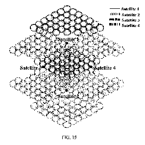
On the basis of FIG. 19, after supplementing the available beam positions of
the transmitting
and receiving signaling beams of other 4 adjacent LEO satellites adjacent in
the direction from
front to back on the same orbit as satellites 3 and 4, the complete coverage
of the signaling beams
in the vicinity of sub-satellite points of the satellites 1, 2, 3 and 4 is
shown in FIG. 20. After
calibration, the unavailable beam positions of the transmitting and receiving
signaling antennas
located in the area where the frequency interference with the GEO satellite
exists are turned off,
the available beam positions of the transmitting and receiving signaling
antennas of all 144 LEO
satellites in the embodiments of the disclosure are superimposed to have more
than one coverage
of the ground.
The dynamic information of the users in the service area is acquired in real
time through the
signaling beams of the transmitting and receiving signaling antennas, and
subsequently the
available movable spot beams of the transmitting and receiving user antennas
of the LEO satellite
are deployed for providing services according to the user demand. After
calibration, the movable
spot beams of the transmitting and receiving user antennas located in the area
where the frequency
interference with the GEO satellite exists are turned off, the available areas
of the movable spot
beams of the transmitting and receiving user antennas of all 144 LEO
satellites in the embodiments
of the disclosure are superimposed to have more than one coverage of the
ground.
When a sub-beam of an LEO satellite is unable to provide service due to
frequency
interference with the GEO satellite, service is provided by a sub-beam of an
adjacent LEO satellite
that does not have frequency interference with the GEO satellite, and the
communication satellite
system of the embodiment of the disclosure thus has the ability of providing
continuous and
uninterrupted services to the users in any region within worldwide or a
certain latitude range.
The beams of the transmitting and receiving signaling antennas of the LEO
satellite all adopt
a frequency spreading mechanism, and different LEO satellites are assigned
with different
frequency spreading codes. This frequency spreading mechanism can solve the
frequency
interference problem when the signaling beams of multiple LEO satellites
provide services to one
24
BI0E2305341PCA
Date Recue/Date Received 2023-08-25
area at the same time.
When the movable spot beams of the transmitting and receiving user antennas of
several
adjacent LEO satellites are required to provide services to the users in the
same area, if the spatial
isolation angle between two sub-beams of the transmitting user antenna and the
receiving user
antenna does not satisfy the minimum acceptable spatial isolation angle
between different LEO
satellites within the communication satellite system (considering that various
influencing factors
in the system are relatively controllable, the minimum acceptable spatial
isolation angle between
different LEO satellites in the communication satellite system can be
relatively small, which is
80 in the embodiment of the disclosure), the frequency interference problem
between different
LEO satellites in the communication satellite system is solved by assigning
different sub-
frequencies to the user sub-beams.
In the embodiment, the communication satellite system can be further expanded,
for example,
a series of LEO satellites at other orbital altitudes and with a smaller
orbital inclination angle can
be further added on the basis of the original system, which can be expanded
into a multi-layer
constellation system in which the number of coverage layers are greatly
increased for low latitude
areas. The expanded system can still solve the frequency interference problem
between i) the
movable spot beams of the transmitting and receiving user antennas and the sub-
beams of the
transmitting and receiving signaling antennas of the LEO satellite and ii) the
GEO satellite by
using the aforementioned method, meanwhile there is of frequency interference
problem between
the movable spot beams of the transmitting and receiving user antennas and the
sub-beams of the
transmitting and receiving signaling antennas of the LEO satellite in the
original system as well
as in the newly expanded system.
After the communication satellite system is expanded, the number of LEO
satellites available
at the same moment is further increased for the ground users, and the LEO
satellite with a larger
communication elevation angle can be used preferably to provide services, and
the average
communication elevation angle of the system will be significantly optimized.
In the embodiments of the disclosure, the LEO satellite in the communication
satellite system
can be further configured with an inter-satellite link antenna and an earth-
satellite feeding antenna
to form a communication satellite system with more complete performance.
The transmitting and receiving user antennas and the transmitting and
receiving signaling
antennas of the LEO satellite in the embodiments of the disclosure can share
valuable frequency
25
BI0E2305341PCA
Date Recue/Date Received 2023-08-25
resources (such as the frequency bands of Ku and Ka) with the GEO satellite.
The disclosure gives only one illustrative embodiment, and numerous variations
of the
invention can be designed by those skilled in the art with ease, and the scope
of the disclosure is
limited by the appended claims.
26
BI0E2305341PCA
Date Recue/Date Received 2023-08-25